Photograph shows the northeast corner of 10th Street and Princess Avenue. OK Used Cars - Western Motors Ltds - used car lot and a building containing The Specialty Shop and another business are pictured. The exposed wall of the Brown Block has been painted over.
Photographs have been glued to a backing board that has warped over time
Scope and Content
Photograph shows street view of north side of Rosser Avenue, primarily the 700 block, along which sewer pipe is being laid. Visible buildings and businesses include: The Fleming Block with Lowes Brothers Clothing and Manitoba Farmers Hedge and Wire Fence Company, the Beaubier Block and its Empire Hotel, A.M. Percival (a grocer), the Brandon Hardware Company (600 block), and the Arlington Hotel (500 block) are visible along the north side of the avenue. The Bank of Hamilton Building is on the southeast corner of 8th Street and Rosser Avenue.
Notes
Writing on the front of the photograph matting reads: 290. Page appears to be from a photo album.
View is west to McDiarmid Drive from approximately 16th Street between Princess and Louise Avenues. Photograph shows: Brandon College, Fleming School, Coronation Park, and West End Community Centre.
Image shows the Brandon College campus from 17th Street looking southwest. The photo was taken after the completion of the original Music Building in 1963, but construction of the Education Building. Also visible are a number of properties on the 200 block of 18th Street and the 200 block of 20th Street.
View is east from approximatley 22nd Street between Lorne and Louise Avenues. Photograph shows: Darrach Hall, Flora Cowan Hall and the Citizens' Science Building, as well as a number of homes in the area.
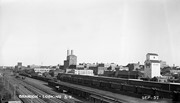
Postcard shows an aerial view of 9th Street facing south in Brandon, Manitoba. Visible businesses and landmarks include: Beaubier Hotel, YMCA/police station, the original CKX Radio station towers on 8th Street (est. 1928 - moved 1940), the old City Hall, Prince Edward Hotel, and the original Manitoba Power commission smokestack on 10th Street.
Notes
Writing on the front of the photograph reads: Brandon, Man., Jerrett Photo. This photograph shows a rare view of the 800-block between Rosser and Princess Avenues.
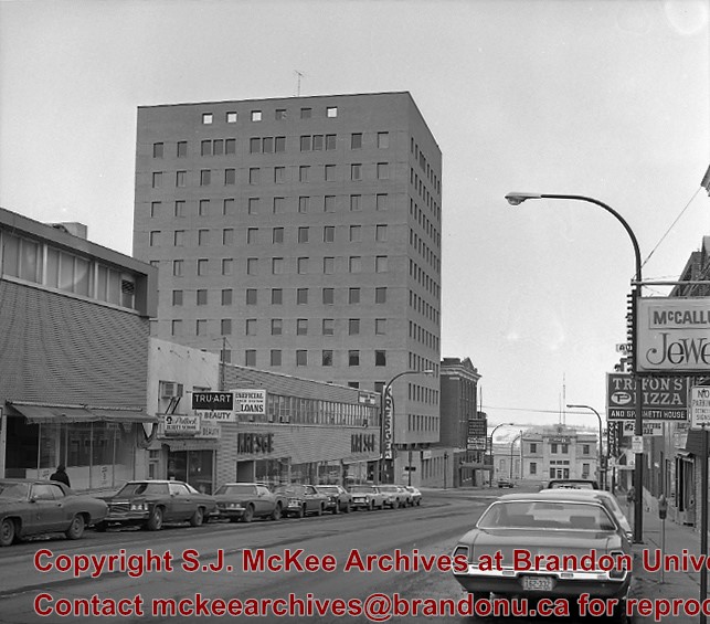
Photograph is looking north northwest along 10th Street to Pacific Avenue. Visible are: Pollock Beauty School, Tru-Art for Beauty, Beneficial Financial Systems Loans, Kresge's, Scotia Towers, Cecil Hotel, CPR Station, and the signs for Stylerite, Trifon's Pizza and Spaghetti House, and McCallum's Jewellers.
Repro Restriction
The McKee Archives is the copyright holder for the Stuckey materials.
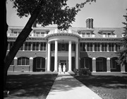
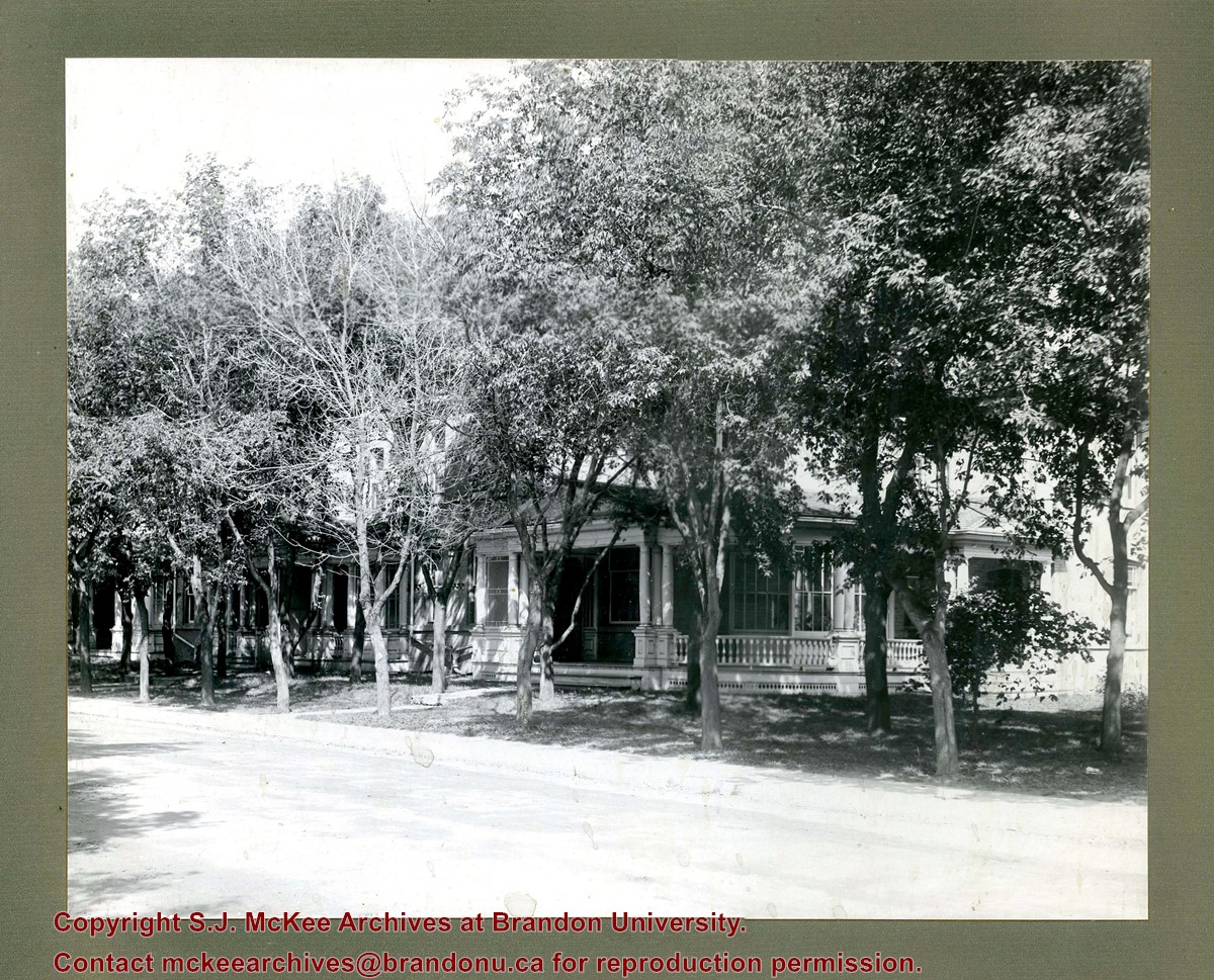
Photograph is looking northwest from approximately the south entrance of the driveway and shows the Citizens' Science Building, the Brandon College Building and part of Clark Hall, as well as the drive way and part of the front lawn.
View is northwest from approximately the corner of 18th Street and Louise Avenue. Photograph shows the Brandon College campus after the completion of Flora Cowan Hall.
Notes
BUPC 2.1.20 is a larger version of this photograph.
The Brandon Daily Sun (26 May 1924, 16) reported the annual church parade of Brandon Lodge 173 Sons of England was held on Sunday, May 25, 1924. The Brandon City Band lead the parade with H.J. Barter, P.P., serving as parade marshal. Over 100 members paraded to St. Mary's Church. Representatives from a variety of lodges participated, including Alexander, Neepawa, Souris, Wawanesa, and Lodge Carpenter Juveniles.
Scope and Content
Photograph shows a parade travelling southwards on 10th Street between Rosser and Princess Avenues. A mounted rider wearing white appears to be leading the parade. A car draped with American and British flags follows. A band follows the vehicle. Individuals wearing white hats walk up the street.
Business visible on the west side (100-block) of 10th Street include: Doig, Rankin, & Robertson, Limited; Bowling Alley, Billiards; Olympia Cafe Candies. The second storey on the Hughes Building has not been erected. The Alexandra Block, Strathcona Block, Olympia Block are visible. A large Union Jack flys from the Canadian Pacific Station. Vehicles are diagonally parked on both sides of 10th Street.
Notes
Back of photograph is stamped: Hughes & Co. Ltd., 1009 Princess Ave., Brandon, Man. Date for photograph obtained from licence plates.
See fonds level description of the Alf Fowler collection for custodial history.
Scope and Content
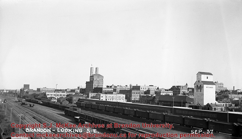
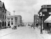
Photo was taken from the 100 block of 10th Street looking north. At the bottom of 10th Street is the CPR Station. Also visible are the Canadian Bank of Commerce, the Cecil Hotel, The Sun, the Royal Bank of Canada and the awning on Davidson & Gowen.
Notes
An 11.75" x 8" (b/w) print of this photograph is located with the orignal at 6-1999.2. A digital scan of the photograph is available on a CD located in the Archives' office.
Storage Range
RG 5 Western Manitoba Manuscript collection - photograph storage drawer
Image is looking east northeast from approximately the 300 block of 23rd Street between Lorne and Louise Avenues. Photograph shows the Brandon College campus after the opening of the original Music Building in 1963, but before the construction of the Education Building in 1966. A number of house on the 300 blocks of 22nd and 21st Streets are visible in the foreground, with the A.E. McKenzie Seed Co., the Prince Edward Hotel and various grain elevators on the horizon.
See fonds level of the CKX records for custodial history.
Scope and Content
Image consists of an aerial view looking southeast at the intersection of Highways 1 and 10 and shows the British American dealer located at the intersection.
See fonds level of the CKX records for custodial history.
Scope and Content
Image consists of an aerial view looking northeast at the intersection of Highways 1 and 10 and shows the British American dealer located at the intersection.


/12-2004_6.jpg?width=1200&404=no-img.jpg&watermark=wmk)
/12-2004_6.jpg?width=180&404=no-img.jpg)


)
%2f12-2004_6.jpg%3fmaxheight%3d1000%26maxwidth%3d1000%26watermark%3dwmk&description=Baldur%2c+MB+from+south)