Photograph is looking east northeast from the southwest corner of the intersection. Visible are: Brandon Hotel, public parking lot and a service station.
Repro Restriction
The McKee Archives is the copyright holder for the Stuckey materials.
Photograph mat is bent. Emulsion problems with image.
Scope and Content
Photograph shows Rosser Avenue in its incipient stages. Canvas tents are mixed amongst wooden structures. The James Smart Hardware store, Winter & O'Neail Groceries & Provisions, and the law office of F.G.A. Henderson in the Molesworth Block can be seen on the north side of Rosser Avenue. A street sign designating 6th Street can be seen below the Winter & O'Neail sign. A horse and buggie is traveling down the dirt track that is Rosser Avenue. Groups of men can be seen congregating outside some of the local businesses.
Notes
Front of photograph reads: Rosser Avenue, Brandon 1882-1883, from east of Six Street. Back of photograph is stamped: I. Bennetto & Co., Photographers, Opposite Post-Office, Winnipeg, Man.
Photographs have been glued to a backing board that has warped over time
Scope and Content
Photograph shows street view of north side of Rosser Avenue, primarily the 700 block. The Fleming Block, Beaubier Block and its Empire Hotel, A.M. Percival (a grocer), the Brandon Hardware Company (600 block), and the Arlington Hotel (500 block) are visible along the north side of the avenue. The Bank of Hamilton Building on the southeast corner of 8th Street and Rosser appears to be under construction. A sign in the second storey window above the main entrance reads: law office. The streets are muddy and a horse and buggy is traveling west on Rosser Avenue.
Notes
Writing on the front of the photograph matting reads: mud November 12, 1906, 339. The photograph appears to be taken from the interior of a builing on the southwest corner of 8th Street and Rosser Avenue. Page appears to be from a photo album.
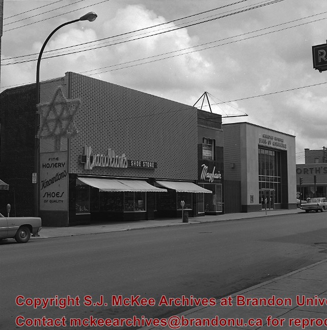
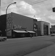
Photograph of west side of 10th Street, Brandon, Manitoba, facing northwest. Visible businesses in the Alexandra Block include Doig's, Box Brothers Hardware and Allied Hardware Stores, followed by Simpsons-Sears and Barry Neill Men's Wear in the Strathcona Block. The Johnny Smith Block is visible in the background.
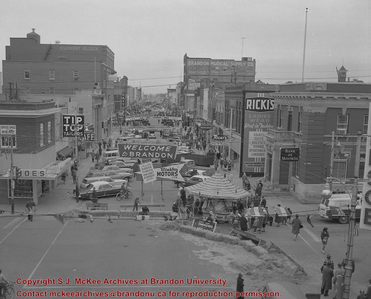
Photograph of 10th Street facing north from Princess Avenue. Vehicles are parallel parked on both sides of the street. The Welcome Brandon sign can be seen at the Rosser Avenue intersection.
Visible businesses on the west side of 10th Street include: Doig's, Box Brothers Hardware and Allied Hardware Stores in the Alexandra Block; followed by Simpsons-Sears in the Strathcona Block. Barry Neill Men's Wear, Kresge's and the Cecil Hotel are also visible. The Johnny Smith Block is visible in the background.
Visible businesses on the east side of 10th Street include: Ollies Steaks and Chops, Elna Sewing Centre, Carlton Cafe, Chop Suey. At the base of the hill the Canadian Pacific train station is visible at the base of the hill.
Notes
Writing on the front of the postcard reads: Tenth St. Brandon, Man.
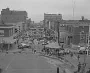
Photograph shows Princess Avenue facing east from 10th Street. On the north side of Princess Avenue, a B/A Service Station, Princess Cafe, Lindenberg Seeds, and the Central Fire Station are visible. Old City Hall with the war memorial and the Prince Edward Hotel are visible on the south side of Princess Avenue. Traffic is travelling one-way on Princess Avenue.
See fonds level description of the Alf Fowler collection for custodial history.
Scope and Content
Photo was taken of 10th Street from Pacific Avenue looking sourth. Visible businesses include: the Cecil Hotel; the Canadian Bank of Commerce; Campbell and Campbell; and the Bank of British North America
Storage Range
RG 5 Western Manitoba Manuscript collection - photograph storage drawer
See fonds level description of the Alf Fowler collection for custodial history.
Scope and Content
Photo was taken of Rosser Avenue from 7th Street looking west. Visible businesses include: ? and Ball; Vincent & MacPherson; W.N. Finlay; Christie's; J. Burchill; the Empire Hotel; and Fleming's Drug Store. A number of people and vehicles are visible on both sides of the street.
Notes
A digital scan of the photograph is available on a CD located in the Archives' office.
Storage Range
RG 5 Western Manitoba Manuscript collection - photograph storage drawer
See fonds level description of the Alf Fowler collection for custodial history.
Scope and Content
Photo was taken of Rosser Avenue, looking east from 11th Street. Visible in the photo are the Merchant's Bank of Canada, A. Smith, and the Union Bank of Canada. A number of people and vehicles are also visible.
Storage Range
RG 5 Western Manitoba Manuscript collection - photograph storage drawer
Photograph shows the southeast corner of 10th Street and Rosser Avenue, Brandon, Manitoba. The Bank of Montreal is situated on the corner. Visible businesses along the east side of 10th Street include: Barclay's Shoe Store, Carlton Cafe, and Ted Heming Jewellers.
Photograph shows the 700-block of Rosser Avenue facing west. Visible businesses on the north side of Rosser Avenue include: Burchill's Music Store, E.W. Woolworth Co. Ltd. 5-10 and 15 Cent Store in the E.E. Evans Block, Empire Hotel, and W.A. Paterson Drugs. Automobiles are parked on both sides of the avenue and at the time the photograph was taken, Rosser Avenue was a two-way street.
Notes
Part of "Souvenir of Brandon, Manitoba, Canada [viewbook], Printed by Photogelatine Engraving Co. Limited, Ottawa." Dates obtained from the Burchill's Music Store Henderson's Brandon City Directory listings (1927-1929). Writing on the front of the photograph reads: Rosser St. [sic.] - Brandon, Man.
Photograph shows seven men posing in front of a wood-framed shack on 10th Street. The men are wearing three-piece suits or vests and long-sleeved shirts. One man can be seen holding an axe another a saw. A double ox-team wagon is in front of the structure.
Notes
Writing on the back of the photograph reads: 10th St. May 1882, Brandon. Photograph is stamped Public Archives Canada.
Photographs have been glued to a backing board that has warped over time
Custodial History
On 16 November 1906, Manitoba was hit by a severe winter storm that began that Thursday evening and extended through the weekend. The Brandon Daily Sun ("Storm Extends Over a Large Territory," 17 Nov. 1906, 1) reported that rail and telegraph services had been disrupted, country roads were impassable, and business in town was at a stand still. Following the weekend, the daily reported the blizzard was one of the greatest in recent memory. CPR trains had been caught in drifts by Carberry and an express car had caught fire and was destroyed ("Worst Storm in Many Years," Brandon Daily Sun, 19 Nov. 1906, 1).
Scope and Content
Photograph shows street view of north side of Rosser Avenue, primarily the 700 block. The Fleming Block, Beaubier Block and its Empire Hotel, A.M. Percival (a grocer), the Brandon Hardware Company (600 block), and the Arlington Hotel (500 block) are visible along the north side of the avenue. The Bank of Hamilton Building on the southeast corner of 8th Street and Rosser appears to be under construction. The streets are muddy and a horse and buggy is traveling west on Rosser Avenue.
Notes
Writing on the front of the photograph matting reads: during the great storm of November 16 1906, 341. The photograph appears to be taken from the interior of a builing on the southwest corner of 7th Street and Rosser Avenue. Page appears to be from a photo album.
Photograph shows the 800 block of Rosser Avenue facing west. On the south side of Rosser Avenue the Nation Block, Christie's Bookstore, and Reesor's Clock can be seen. A number of horse and buggies/carriages are travelling along Rosser Avenue.
Photograph shows a sketch of the intersection at 10th Street and Princess Avenue, Brandon, Manitoba facing northeast. A proposed two-storey bowling alley is situated on the northeast corner of 10th Street and Princess Avenue.


)