Photograph is looking northwest from approximately the south entrance of the driveway and shows the Citizens' Science Building, the Brandon College Building and part of Clark Hall, as well as the drive way and part of the front lawn.
View is west to McDiarmid Drive from approximately 16th Street between Princess and Louise Avenues. Photograph shows: Brandon College, Fleming School, Coronation Park, and West End Community Centre.
View is east from approximatley 22nd Street between Lorne and Louise Avenues. Photograph shows: Darrach Hall, Flora Cowan Hall and the Citizens' Science Building, as well as a number of homes in the area.
View is northwest from approximately the corner of 18th Street and Louise Avenue. Photograph shows the Brandon College campus after the completion of Flora Cowan Hall.
Notes
BUPC 2.1.20 is a larger version of this photograph.
For biographical information on Sarah Persis Darrach see RG 1 Brandon College fonds, Series 9: Clark Hall women's residence.
Custodial History
See collection level description of the Maureen Johnson collection (10-2009) for custodial history.
Scope and Content
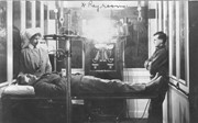
Photograph shows a soldier (?) laying on the x-ray table with Sarah Persis (Johnson) Darrach standing at the head of the table. Their is another man leaning against the opposite wall.
Notes
Writing on the back of the photograph states that Darrach had to stand still for 10 minutes while the photograph was taken.
View is southwest from the north side of Princess Avenue. Photograph shows the north driveway entrance on campus. The original Music Building, the A.E. McKenzie Building, Clark Hall and part of the Brandon College Building are visible.
View is north, taken from approximatley 19th Street and Rosser Avenue. Photograph shows: Clark Hall, the A.E. McKenzie Building, the J.R.C. Evans Lecture Theatre, H-Huts, Darrach Hall and Flora Cowan Hall, as well as a number of homes in the area.
Photograph of 10th Street facing north from Princess Avenue. Vehicles are parallel parked on both sides of the street. The Welcome Brandon sign can be seen at the Rosser Avenue intersection.
Visible businesses on the west side of 10th Street include: Doig's, Box Brothers Hardware and Allied Hardware Stores in the Alexandra Block; followed by Simpsons-Sears in the Strathcona Block. Barry Neill Men's Wear, Kresge's and the Cecil Hotel are also visible. The Johnny Smith Block is visible in the background.
Visible businesses on the east side of 10th Street include: Ollies Steaks and Chops, Elna Sewing Centre, Carlton Cafe, Chop Suey. At the base of the hill the Canadian Pacific train station is visible at the base of the hill.
Notes
Writing on the front of the postcard reads: Tenth St. Brandon, Man.
Photograph of an east side of 10th Street facing north from Princess Avenue. Visible businesses include: Thunderbird Bowl, Canadian Pacific Telegraphs, Pittsburgh Paint & Glass, Strand Theatre, Trans Canada Credit Loans, Ted Heming Jewellers, Carlton Cafe, McKenzie Seeds, Clement Block, Mitrou's Cafe and Tea Room, and Brandon Musical Supply Ltd. Vehicles parked on 10th Street are facing north.
Notes
Photograph dated from "Tara's Bulba," the movie playing at the Strand Theatre and similiar vehicles captured in the photograph.
Doig's, originally located on Rosser Avenue, moved to the 10th Street location in 1921.
Scope and Content
Photograph of west side of 10th Street, Brandon, Manitoba, facing northwest. Visible businesses in the Alexander Block include Doig's, Box Brothers Hardware and Allied Hardware Stores, followed by Simpsons-Sears and Barry Neill Men's Wear in the Strathcona Block. The Johnny Smith Block is visible in the background.
Photograph shows the Red Indian (Gasoline) Station on the north side Princess Avenue between 9th and 10th Streets, Brandon. Attached to the west side of the gas station is another shop which contains Hutchings' Drug Store. The Alexandra Block on 10th Street is visible in the background.


+north+side+Princess+Avenue+between+9th+Street+and+10th+Street%2c+Brandon%2c+Manitoba)