Situated in the R.M. of Whitehead on the Little Saskatchewan River, the 10 Mile Dam was a 14 kilometer transmission line that supplied the city of Brandon with power. The Brandon Electric Light Company built the dam in 1900 and it is considered Manitoba's first hydroelectic power generating station. The dam spanned approximately 80 meters and was constructed from timber and reinforced with clay and stone. The station was decommissioned in 1924.
Scope and Content
Photograph shows 10 Mile Dam, also known as the Brandon Dam or Minnedosa River Hydro Plant.
Notes
Writing on the back of the photograph reads: "10 mile dam". Biographical information obtained from Manitoba Historical Society.
Situated in the R.M. of Whitehead on the Little Saskatchewan River, the 10 Mile Dam was a 14 kilometer transmission line that supplied the city of Brandon with power. The Brandon Electric Light Company built the dam in 1900 and it is considered Manitoba's first hydroelectic power generating station. The dam spanned approximately 80 meters and was constructed from timber and reinforced with clay and stone. The station was decommissioned in 1924.
Scope and Content
Photograph shows 10 Mile Dam, also known as the Brandon Dam or Minnedosa River Hydro Plant. The dam's timber construction is quite evident in the picture.
Notes
Writing on the back of the photograph reads: McGuinness (Manitoba Hydro), on Little Saskatchewan.
Situated in the R.M. of Whitehead on the Little Saskatchewan River, the 10 Mile Dam was a 14 kilometer transmission line that supplied the city of Brandon with power. The Brandon Electric Light Company built the dam in 1900 and it is considered Manitoba's first hydroelectic power generating station. The dam spanned approximately 80 meters and was constructed from timber and reinforced with clay and stone. The station was decommissioned in 1924.
Alonzo Archibald Rowe (b. 1862, London, ON; d. 22 Oct 1951, Brandon). The Rowes were considered Brandon area pioneers. Alonzo’s father, Alonzo L. Rowe, came to Brandon with his family in 1881, where the family had a furniture and undertaker business on the west side of 10th Street between Rosser and Princess Avenues. In 1885, the family began farming west of Brandon and Alonzo Archibald served as a councilor and then a reeve in the R.M. of Whitehead. He returned to Brandon in 1907 and served with the Brandon Police Department until 1910, when he returned to farming, this time in Arrow River. A.A. Rowe returned to Brandon in 1915 to work as a Provincial Licenses Inspector, a position he held until 1938. (Source: Obituary, Brandon Daily Sun 22 Oct 1951)
Custodial History
Photograph was in possession of Mrs. Ruby Miles, who passed the image on to Fred McGuinness. McGuinness makes reference to Mrs. Miles and this photograph in his Sunbeams column (Source: F.A. Rosser, "Another interesting chat with a daughter of the plains," Brandon Sun 18 Aug 1981).
Scope and Content
Photograph shows four fishermen at 10 Mile Dam, also known as the Brandon Dam or Minnedosa River Hydro Plant. The fishermen in the photo are identified as George H. Rowe and his father A.A. Rowe, Dr. Wilfred Bigelow, and Al Collins.
Notes
Writing on the back of the photograph reads: at Brandon Dam, [right to left] son and father - George H. ROWE, Mr. A.A. ROWE, Dr. BIGELOW, Al COLLINS (dam?, 1906?, George born March 1897); Jerrett's Photo-Services, May 7 1938.
The Medicine Hat Exhibition and Stampede Parade Day was held on Thursday, July 19, 1962, at 9:30 a.m. The local newspaper reported that approximately 24,000 people were in attendance to see parade marshall Rod Ashburner leading 175 entries consisting of 90 floats, 75 horses, and 10 bands. There were 19 parade categories eligible for $12,000 in prize money and included: junior and senior cowboys and cowgirls; fancy and Shetland ponies; sulky class open; comic, commercial, industrial and organizational floats; decorated cars; special ranch class; 4-H Clubs; and a non-competitive class.
The parade route started at Second St. and Allowance Ave., from Second St. to Ash Ave., north on Ash to First St. SE., from First St. S.E. to Fourth Ave., south to Second St. to South Railway St., south on South Railway St. to Third St., with a finish at McLeod Trail. A route map was published in the Medicine Hat News the day before the parade.
Aerial photographs of the parade were taken by Medicine Hat News photographer Howard Heid (1930-2005) from the private helicopter of John Bourn. Bourn was a pilot from Woodville, Wisconsin, who chartered his four-seater helicopter for sight-seers at exhibitions and stampedes across the county.
(Sources: Pat Currie, "Let 'Er Go!," Medicine Hat News, 19 July 1962,1; Harald Gunderson, "'Eye in the Sky' Best Parade View," Medicine Hat News, 19 July 1962,1; "Parade Starts at 9:30 Sharp," 18 July 1962)
Scope and Content
Photograph shows an aerial view of the Medicine Hat Exhibition and Stampede Parade route with a focus west of the railway allowance, showing First Street SE, Second Street SE, and Third Street SE.
Notes
This photograph shows the neighbourhood before rezoning and commercial development.
Photograph shows the train station at the port of Mulgrave, Nova Scotia. Possibly the site where the HMCS Alachasse was docked when Fred McGuinness was a telegraphers in the Canadian Navy.
Notes
Writing on the back of the postcard reads: AZO post card
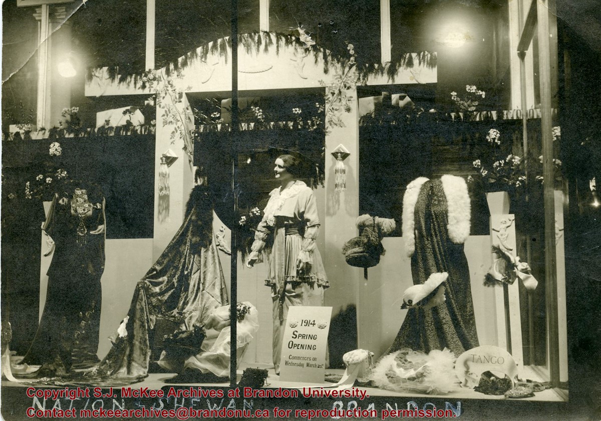
Erected in 1889, on the southeast corner of Rosser Avenue and 7th Street at 806 Rosser Avenue, this block was designed by Brandon architect W.H. Shillinglaw. At the time of its construction the structure housed the Nation & Shewan Department Store, one of Brandon’s largest and most successful drygoods businesses, owned and operated by Fred Nation and Alexander Shewan.
Major improvements were made to the store and an annex was added in 1910. Some of the renovation additions included, but were not limited to, an updated frontage with new copper sash windows and prismatic glass tops, plate glass windows, new fixtures and carpet. With the renovations the floor space of the business was to be almost doubled. The stock of the business also increased, with the Brandon Weekly Sun reporting that when finished, Nation & Shewan would be a “store of which the citizens of Brandon will be justly proud.” The drygoods firm operated until Nation’s death 1926, when it became known as A. Shewan Limited. From 1933 to 1944, the business was known as Shewan and Son. Shortly thereafter, the Metroplitan Stores Ltd began operating out of the Nation & Shewan Block.
In 2000, the Town Centre prepared to knock down the Red Apple Building, formerly the Nation & Shewan Block. The demolition was to make way for the new atrium and entrance for the mall, and begin a new period of redevelopment at the downtown shopping centre.
[History/Bio written by Christy Henry (SJ McKee Archives) and Eileen Trott (Daly House Museum), researched by Morganna Maylon, for 2015 photographic exhibition "Gowen's Brandon: Then and Now".]
Custodial History
Photograph was given to Fred McGuinness by Linda Bilkoski (nee Lepard) of Lac du Bonnet, MB.
Scope and Content
Photograph shows a display of women's clothing and accessories in the window at Nation & Shewan. A sign reads: 1914 Spring Opening commences on Wednesday March 25th.
Notes
Writing on the back of the photograph reads: Mrs. E. Harden, 33-10th St., City. According to the Henderson's Brandon City Directories, Catharine "Kate" Harden (nee Chalmers) worked as a cashier at Nation & Shewan from 1913 to 1914.
Brient was a point along the Algoma Central Railway line that connected the Helen Mine to the Michipicoten Harbour. It is located southwest of Wawa, Ontario.
Scope and Content
Photograph shows ore box cars in a railway yard.
Notes
Writing beneath the photograph in the album reads: yard at Brient
Trembley was a point along the Algoma Central Railway line that connected the Helen Mine to the Michipicoten Harbour. It is located southwest of Wawa, Ontario.
Scope and Content
Photograph shows railroad tracks. A line of ore cars stretch along one track. Writing on the side of one of the cars (#3017) reads: Algoma Central Railway Co.
Notes
Writing beneath the photograph in the album reads: Trembley - Ore Cars
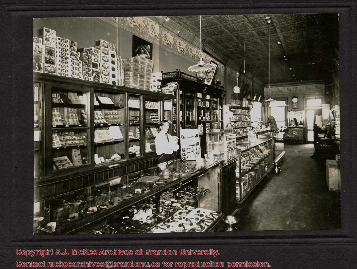
The decorative ceiling and border are consistent with another photograph in the McGuinness collection (see 20-2009.78) in which Gordon Irwin is identified. According to Henderson's 1909 Brandon City Directory, Gordon Irwin - a barber - and tobacconist J.S. Rosby shared at storefront at 919 Rosser Avenue. This address is situated on the north side of Rosser Avenue, adjacent to a laneway. It is possible that the back of the shop overlooks the Grand Union Hotel on the corner of Pacific Avenue and 10th Street.
Scope and Content
Photograph shows the interior of a store primarily selling pipes and cigars. An ornate tin ceiling and wallpaper border are evident. A barber shop area can be seen in the back of the shop near the exit.
Notes
Writing on the back reads: Harold Tackaberry says may have been Jory's or Waldron's, now part of Knowlton's. The handwriting is Fred McGuinness'.
Photograph is stained and water damaged. A newspaper clipping about William (Billy) Muir is glued to the top left hand corner of the mat. The image is exfoliated in the right hand corner. The negative has been reverse printed.
History / Biographical
Coombs & Stewart opened the first general store in Brandon in 1881, which was located on 6th Street and Pacific Avenue. According to G.F. Barker (Brandon: A City, 1977, 291), William (Billy) Muir worked at the store until he opened his own grocery store in 1888.
Custodial History
Donated to Fred McGuinness by Allena Strath (nee Coombs).
Scope and Content
Photograph shows the Coombs & Stewart general store located on the corner of Pacific Avenue and 6th Street. A group of men pose in front of the wood-framed store.
Notes
Back of photograph reads: One of first stores in Brandon, Coombs...[?]
Brient was a point along the Algoma Central Railway line that connected the Helen Mine to the Michipicoten Harbour. It is located southwest of Wawa, Ontario.
Scope and Content
Photograph shows several men standing on railway tracks before a wood-framed train station in the winter. A sign attached to the station reads: British American Express Co. The man in the foreground appears to have a mailbag over on his back and several newspapers tucked beneath his arm.
Notes
Writing beneath the photograph in the album reads: station at Brient
In 1901, American entrepreneur Francis Hector Clergue (1856-1939) obtained the charter for the Ontario, Hudson Bay and Western Railway. Following his purchase, he reincoporated the Algoma Central Railway to the Algoma Central and Hudson's Bay Railway. (Source: Sault St. Mairie Public Library, "Transportation - Algoma Central Railway," Sault History Online, 2008)
Scope and Content
Photograph shows railroad tracks cutting through the Canadian Shield.
Notes
Writing beneath the photograph in the album reads: Algoma Central & Hundson Bay Ry.
The Lake Talbot tresle was a point along the Algoma Central Railway line that connected the Helen Mine to the Michipicoten Harbour. It is located north of Wawa and southwest of the Helen Mine.
Scope and Content
Photograph shows several men walking a railway line. Before them is a tresle bridge.
Notes
Writing beneath the photograph in the album reads: Lake Talbott Tresle [sic.]
Corners of photograph mat are bent. Picture is cracked.
Scope and Content
Photograph shows an early view of Brandon's 6th Street in the 1880s. The Winter & O'Neail Groceries & Provisions and James Smart Hardware storefronts have been photographed. A street sign designating 6th Street can be seen below the Winter & O'Neail sign. A horse and cart is parked in front of the grocery store. A number of men wearing hats and jackets are standing along the boardwalk while posing for the picture. Lumber/timber saws are displayed in teh windows of the hardware store.
Notes
Front of photograph reads: 6th Street, Brandon, Manitoba, 1881-1882, Entrance [to Winter & O'Neail] corner of Rosser Ave & 6th Street.
These records were produced between 1986 and 1987, the researching and writing period for the book Manitoba: The Province & The People. Published in 1987 by Hurtig Publishers (Edmonton), Manitoba is a 203-page hard cover book, containing 2 maps, and 58 images.
BU faculty members Dr. Kenneth “Ken” Stephen Coates, Assistant Professor of History, and Mr. Fred McGuinness, Lecturer in Journalism, authored the book. Assisting the writers was a research team of three BU history students: Diane Fowler, Rob McGarva, and Bruce Stadfeld. All three students were former research assistants for The Pride of the Land monograph.
The authors cover 117 years of Manitoba social history, starting with the Red River Settlement and the Dominion of Canada expansion in the 1870s, followed by the war years, and the emergence of modern, contemporary Manitoba.
Custodial History
Records were collected and created by McGuinness, Coates, and the research students during the creation of the book, Manitoba: The Province & The People. The materials were donated to the McKee Archives by the Estate of Fred McGuinness circa 2011. The Archives accessioned the records in 2015.
Scope and Content
The subseries consists of textual records, created and collected during the production of the monograph Manitoba: The Province & The People. It includes copies of newspaper articles from newspapers (such as the Brandon Sun, Brandon Daily Sun, Winnipeg Free Press, and Saturday Night), copies of journal articles about the Red River Valley, Government of Manitoba industrial publications, photocopies and a few original photographs used in the publication, and drafts for chapter “brites.”
Notes
Information in the history/biography was taken from the “Manitoba: The Province & The People’s” acknowledgments section
Accruals
Closed
Language Note
Fred McGuinness often uses journalistic jargon to label his files. A
“brite” refers to a short, amusing story. McGuinness often organized his ideas and research materials by potential brite topic
Finding Aid
A file level inventory is available
Storage Location
2015 accessions
Related Material
Original copies of the July 10, 1899 and July 12, 1899 editions of the Brandon Daily Sun containing articles about the Hilda Blake trial are available in the oversize drawers in the Reading Room
See McG 1.2 Box 3 File 48 for correspondence pertaining to royalties for this monograph
Arrangement
Arrangement was artificially created by the Archives. Files in this subseries have been arranged according to the order in which brites first appear in the book
Original file titles, where available, have been recorded in square brackets after the file title assigned by the Archives
For this subseries, the original photographs have been relocated to the McGuinness collection photograph series (McG 9)
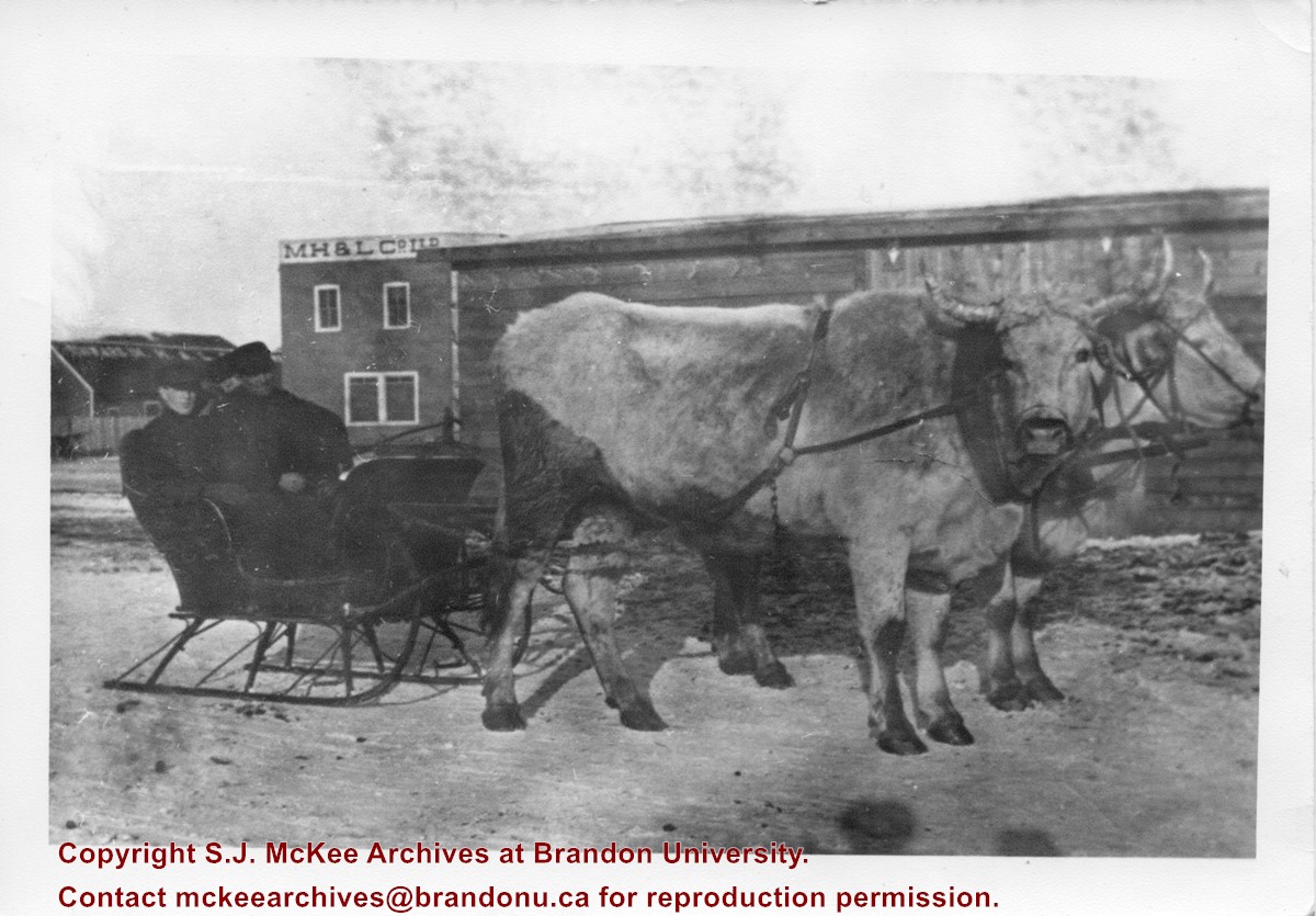
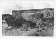
Given to Fred McGuinness by George Creighton, 1980?
Scope and Content
Photograph shows two men seated in a sleigh pulled by two oxen. Behind the men is a wooden building with a M.H. & L Co. Ltd. sign on its side.
Notes
Writing on the front of the photograph reads: 7.3.80. file family letters. picture of dad's store at Hamiota. M.H.& L. > Manitoba Hardware & Lumber Co. George Creighton gave me this. McG.


