Skip header and navigation

Revise Search

20 records – page 1 of 1.

Part Of
Fred McGuinness collection
Description Level
Item
GMD
graphic
Date Range
[19--]
Accession Number
20-2009
Other Title Info
Formerly called "bridge over Souris River?"
Part Of
Fred McGuinness collection
Description Level
Item
Series Number
McG 9
Item Number
20-2009.100
Accession Number
20-2009
GMD
graphic
Date Range
[19--]
Physical Description
10" x 8" (b/w)
History / Biographical
Kirkham's Bridge was built in 1906, to replace an earlier wooden bridge. The bridge was used until 1981, when it was purchased by the Town of Birtle and moved to a newsite. A former railway pridge was installed in its place.
Scope and Content
Photograph shows Kirkham's Bridge, a steel truss bridge that spanned the Little Saskatchewan River in the Municipality of Riverdale.
Notes
Identification of the bridge provided by Ken Storie (2023). Additional information taken from the Manitoba Historical Society website.
Subject Access
bridges
Rivers
Storage Location
RG 5 photograph storage drawer 2 (hanging photos)
Images
Show Less

Steel bridge, Souris

http://archives.brandonu.ca/en/permalink/descriptions13686
Part Of
Fred McGuinness collection
Description Level
Item
GMD
graphic
Date Range
1903
Accession Number
6-2008
Part Of
Fred McGuinness collection
Creator
Photographer(?): JBK
Description Level
Item
Series Number
McG 9
Item Number
6-2008.1
Accession Number
6-2008
GMD
graphic
Date Range
1903
Physical Description
6" x 4.5" (b/w)
Material Details
On matting
Physical Condition
Some damage to matting, especially on the back. Photograph is good. There are two brads in the matting (one on the left edge, one on the right edge). The brads are connected to a (broken) red ribbon likely used to hang the photograph.
Custodial History
Kay Sullivan gave the photograph to Fred McGuinness in August 2007.
Scope and Content
Photograph was taken from the riverbank and shows the steel bridge in Souris, MB. A second wooden bridge is visible behind the steel bridge. The residence of Dr. W.A. Sherrin can be seen to the right of the bridges.
Notes
Dr. Sherrin's residence was identified using the Illustrated Souvenir of Souris, Manitoba (p. 38).
Name Access
Souris, MB
W.A. Sherrin
Souris River
Subject Access
bridges
Storage Location
RG 5 photograph storage drawer 2 (hanging photos)
Images
Show Less

Suspension foot-bridge, Souris, Man.

http://archives.brandonu.ca/en/permalink/descriptions13687
Part Of
Fred McGuinness collection
Description Level
Item
GMD
graphic
Date Range
[1903?]
Accession Number
6-2008
Part Of
Fred McGuinness collection
Creator
Photographer(?): JBK(?)
Description Level
Item
Series Number
McG 9
Item Number
6-2008.2
Accession Number
6-2008
GMD
graphic
Date Range
[1903?]
Physical Description
6.75" x 4.5" (b/w)
Material Details
On matting
Physical Condition
Some damage to matting, especially on the back. There is also significant water damage to the image. There are two brads in the matting (one on the left edge, one on the right edge). The brads are connected to a red ribbon likely used to hang the photograph.
Custodial History
Kay Sullivan gave the photograph to Fred McGuinness in August 2007.
Scope and Content
Photograph was taken from the riverbank and shows the suspension foot-bridge in Souris, MB. A number of buildings, both commerial and possibly residential, can be seen on the far side of the river.
Name Access
Souris, MB
Souris River
Swinging Bridge
Subject Access
bridges
swinging bridge
Storage Location
RG 5 photograph storage drawer 2 (hanging photos)
Images
Show Less

Morning reflection of Brandon's skyline on the Assiniboine River

http://archives.brandonu.ca/en/permalink/descriptions13781
Part Of
Fred McGuinness collection
Description Level
Item
GMD
graphic
Date Range
[1980s]
Accession Number
20-2009
Part Of
Fred McGuinness collection
Creator
Photographer: Sandy Black
Description Level
Item
Series Number
McG 9
Item Number
20-2009.92
Accession Number
20-2009
GMD
graphic
Date Range
[1980s]
Physical Description
5.5" x 3.5" (colour)
Material Details
postcard
Scope and Content
Postcard shows the 100 block of 10th Street facing north. The CPR train station can be seen at the end of 10th Street. The sign for the Rex Cafe is visible on the west side of 10th Street. On the east side of 10th Street, billboards for Campbell & Campbell furniture are visible as well as signs for Pianos and the Orpheum Theatre. Motorists and cyclists share the road. Street car tracks run the length of 10th Street.
Notes
Back of postcard reads: Morning reflection of Brandon's skyline on the Assiniboine River, photo by Sandy Black, printed in Brandno, Manitoba, Canada by Leech Printing Ltd.
Name Access
Assiniboine River
McKenzie Seeds
Scotia Towers
Subject Access
Rivers
downtown
Storage Location
RG 5 photograph storage drawer 2 (hanging photos)
Images
Show Less

Building fire near rail yard

http://archives.brandonu.ca/en/permalink/descriptions14127
Part Of
Fred McGuinness collection
Description Level
Item
GMD
graphic
Date Range
[1960-1965]
Accession Number
1-2015
Part Of
Fred McGuinness collection
Description Level
Item
Series Number
McG 9
Item Number
1-2015.196
Accession Number
1-2015
GMD
graphic
Date Range
[1960-1965]
Physical Description
3" x 3" (b/w)
Scope and Content
Photograph shows a dark cloud of smoke emerging from a building or warehouse near a train yard.
Subject Access
fires
trains
railways
Storage Location
RG 5 photograph storage drawer 2 (hanging photos)
Arrangement
BR #3 Family photos
Images
Show Less

Building fire near rail yard

http://archives.brandonu.ca/en/permalink/descriptions14128
Part Of
Fred McGuinness collection
Description Level
Item
GMD
graphic
Date Range
[1960-1965]
Accession Number
1-2015
Part Of
Fred McGuinness collection
Description Level
Item
Series Number
McG 9
Item Number
1-2015.197
Accession Number
1-2015
GMD
graphic
Date Range
[1960-1965]
Physical Description
3" x 3" (b/w)
Scope and Content
Photograph shows a dark cloud of smoke emerging from a building or warehouse near a train yard.
Subject Access
fires
trains
railways
Storage Location
RG 5 photograph storage drawer 2 (hanging photos)
Arrangement
BR #3 Family photos
Images
Show Less

Fishing at 10 Mile Dam

http://archives.brandonu.ca/en/permalink/descriptions13731
Part Of
Fred McGuinness collection
Description Level
Item
GMD
graphic
Date Range
1906?
Accession Number
20-2009
Part Of
Fred McGuinness collection
Description Level
Item
Series Number
McG 9
Item Number
20-2009.41
Accession Number
20-2009
GMD
graphic
Date Range
1906?
Physical Description
6.5" x 4.75" (b/w)
Material Details
reproduction
History / Biographical
Situated in the R.M. of Whitehead on the Little Saskatchewan River, the 10 Mile Dam was a 14 kilometer transmission line that supplied the city of Brandon with power. The Brandon Electric Light Company built the dam in 1900 and it is considered Manitoba's first hydroelectic power generating station. The dam spanned approximately 80 meters and was constructed from timber and reinforced with clay and stone. The station was decommissioned in 1924. Alonzo Archibald Rowe (b. 1862, London, ON; d. 22 Oct 1951, Brandon). The Rowes were considered Brandon area pioneers. Alonzo’s father, Alonzo L. Rowe, came to Brandon with his family in 1881, where the family had a furniture and undertaker business on the west side of 10th Street between Rosser and Princess Avenues. In 1885, the family began farming west of Brandon and Alonzo Archibald served as a councilor and then a reeve in the R.M. of Whitehead. He returned to Brandon in 1907 and served with the Brandon Police Department until 1910, when he returned to farming, this time in Arrow River. A.A. Rowe returned to Brandon in 1915 to work as a Provincial Licenses Inspector, a position he held until 1938. (Source: Obituary, Brandon Daily Sun 22 Oct 1951)
Custodial History
Photograph was in possession of Mrs. Ruby Miles, who passed the image on to Fred McGuinness. McGuinness makes reference to Mrs. Miles and this photograph in his Sunbeams column (Source: F.A. Rosser, "Another interesting chat with a daughter of the plains," Brandon Sun 18 Aug 1981).
Scope and Content
Photograph shows four fishermen at 10 Mile Dam, also known as the Brandon Dam or Minnedosa River Hydro Plant. The fishermen in the photo are identified as George H. Rowe and his father A.A. Rowe, Dr. Wilfred Bigelow, and Al Collins.
Notes
Writing on the back of the photograph reads: at Brandon Dam, [right to left] son and father - George H. ROWE, Mr. A.A. ROWE, Dr. BIGELOW, Al COLLINS (dam?, 1906?, George born March 1897); Jerrett's Photo-Services, May 7 1938.
Name Access
10 Mile Dam
Ten Mile Dam
Brandon Dam
Minnedosa River Hydro Plant
Brandon Electric Light Company
Little Saskatchewan River
George H. Rowe
A.A. Rowe
Dr. Bigelow
Al Collins
Subject Access
dams
Rivers
fishing
Storage Location
RG 5 photograph storage drawer 2 (hanging photos)
Related Material
Ruby Miles collection 14-2003
Images
Show Less

Mulgrave, N.S. train station postcard

http://archives.brandonu.ca/en/permalink/descriptions13938
Part Of
Fred McGuinness collection
Description Level
Item
GMD
graphic
Date Range
1940s
Accession Number
1-2015
Part Of
Fred McGuinness collection
Creator
Photograph by: Fad Foto
Description Level
Item
Series Number
McG 9
Item Number
1-2015.10
Accession Number
1-2015
GMD
graphic
Date Range
1940s
Physical Description
5.5" x 3.5" (b/w)
Material Details
postcard
Scope and Content
Photograph shows the train station at the port of Mulgrave, Nova Scotia. Possibly the site where the HMCS Alachasse was docked when Fred McGuinness was a telegraphers in the Canadian Navy.
Notes
Writing on the back of the postcard reads: AZO post card
Name Access
Mulgrave, Nova Scotia
Subject Access
train stations
railways
Storage Location
RG 5 photograph storage drawer 2 (hanging photos)
Arrangement
Loose photos in funny trunk
Images
Show Less
Part Of
Fred McGuinness collection
Description Level
Item
GMD
graphic
Date Range
1900-1924
Part Of
Fred McGuinness collection
Description Level
Item
Series Number
McG 9
Item Number
20-2009.26
GMD
graphic
Date Range
1900-1924
Physical Description
4.25" x 2.5" (b/w)
History / Biographical
Situated in the R.M. of Whitehead on the Little Saskatchewan River, the 10 Mile Dam was a 14 kilometer transmission line that supplied the city of Brandon with power. The Brandon Electric Light Company built the dam in 1900 and it is considered Manitoba's first hydroelectic power generating station. The dam spanned approximately 80 meters and was constructed from timber and reinforced with clay and stone. The station was decommissioned in 1924.
Scope and Content
Photograph shows 10 Mile Dam, also known as the Brandon Dam or Minnedosa River Hydro Plant.
Notes
Writing on the back of the photograph reads: "10 mile dam". Biographical information obtained from Manitoba Historical Society.
Name Access
10 Mile Dam
Ten Mile Dam
Brandon Dam
Minnedosa River Hydro Plant
Brandon Electric Light Company
Little Saskatchewan River
Subject Access
dams
Rivers
hydroelectric dams
hydroelectric generation
Storage Location
RG 5 photograph storage drawer 2 (hanging photos)
Images
Show Less
Part Of
Fred McGuinness collection
Description Level
Item
GMD
graphic
Date Range
1900-1924
Accession Number
20-2009
Part Of
Fred McGuinness collection
Description Level
Item
Series Number
McG 9
Item Number
20-2009.95
Accession Number
20-2009
GMD
graphic
Date Range
1900-1924
Physical Description
4.25" x 2.5" (b/w)
History / Biographical
Situated in the R.M. of Whitehead on the Little Saskatchewan River, the 10 Mile Dam was a 14 kilometer transmission line that supplied the city of Brandon with power. The Brandon Electric Light Company built the dam in 1900 and it is considered Manitoba's first hydroelectic power generating station. The dam spanned approximately 80 meters and was constructed from timber and reinforced with clay and stone. The station was decommissioned in 1924.
Scope and Content
Photograph shows 10 Mile Dam, also known as the Brandon Dam or Minnedosa River Hydro Plant. The dam's timber construction is quite evident in the picture.
Notes
Writing on the back of the photograph reads: McGuinness (Manitoba Hydro), on Little Saskatchewan.
Name Access
10 Mile Dam
Ten Mile Dam
Brandon Dam
Minnedosa River Hydro Plant
Brandon Electric Light Company
Little Saskatchewan River
Subject Access
dams
Rivers
hydroelectric dams
hydroelectric generation
Storage Location
RG 5 photograph storage drawer 2 (hanging photos)
Related Material
Lawrence Stuckey collection 1-2002.3.1J1
Images
Show Less

Album - station at Brient

http://archives.brandonu.ca/en/permalink/descriptions14217
Part Of
Fred McGuinness collection
Description Level
Item
GMD
graphic
Date Range
[1900s]
Accession Number
1-2015
Part Of
Fred McGuinness collection
Description Level
Item
Series Number
McG 9
Item Number
1-2015.277.A9
Accession Number
1-2015
GMD
graphic
Date Range
[1900s]
Physical Description
4" x 2.5" (b/w)
Material Details
mounted in album
Physical Condition
Photo is warped
History / Biographical
Brient was a point along the Algoma Central Railway line that connected the Helen Mine to the Michipicoten Harbour. It is located southwest of Wawa, Ontario.
Scope and Content
Photograph shows several men standing on railway tracks before a wood-framed train station in the winter. A sign attached to the station reads: British American Express Co. The man in the foreground appears to have a mailbag over on his back and several newspapers tucked beneath his arm.
Notes
Writing beneath the photograph in the album reads: station at Brient
Name Access
Brient, Ontario
Subject Access
railways
train stations
Transportation
winter
Storage Location
1-2015 McG 1.4 Box 1 (in stacks, top shelf)
Images
Show Less

CPR Station viewbook postcard

http://archives.brandonu.ca/en/permalink/descriptions13878
Part Of
Fred McGuinness collection
Description Level
Item
GMD
graphic
Date Range
1927-1929
Accession Number
20-2009
Part Of
Fred McGuinness collection
Creator
Printed by Photogelatine Engraving Co. Ltd., Ottawa
Description Level
Item
Series Number
McG 9
Item Number
20-2009.188
Accession Number
20-2009
GMD
graphic
Date Range
1927-1929
Physical Description
3.5" x 5.5" (b/w)
Material Details
postcard
Scope and Content
Photograph shows the CPR Train Station on Pacific Avenue and 10th Street.
Notes
Part of "Souvenir of Brandon, Manitoba, Canada [viewbook], Printed by Photogelatine Engraving Co. Limited, Ottawa." Dates obtained from the Burchill's Music Store Henderson's Brandon City Directory listings (1927-1929). Writing on the front of the photograph reads: CPR Station, Brandon, Man.
Name Access
CPR Station
Subject Access
downtown
street scenes
Transportation
train stations
Brandon business buildings & facilities before 1940
store exteriors
Storage Location
RG 5 photograph storage drawer 2 (hanging photos)
Arrangement
From 20-2009 photos
Images
Show Less

Clerk William Frederick McGuinness

http://archives.brandonu.ca/en/permalink/descriptions14018
Part Of
Fred McGuinness collection
Description Level
Item
GMD
graphic
Date Range
[1900s]
Accession Number
1-2015
Part Of
Fred McGuinness collection
Description Level
Item
Series Number
McG 9
Item Number
1-2015.88
Accession Number
1-2015
GMD
graphic
Date Range
[1900s]
Physical Description
2.5" x 4" (b/w)
Physical Condition
Photograph is folded and torn
Scope and Content
Photograph shows William Frederick McGuinness (on the right) standing with another man on a platform in front of a train.
Name Access
William Frederick McGuinness
W.F. McGuinness
Subject Access
trains
Storage Location
RG 5 photograph storage drawer 2 (hanging photos)
Arrangement
BR #3 Family pictures
Images
Show Less

William Frederick McGuinness in railway yard

http://archives.brandonu.ca/en/permalink/descriptions14021
Part Of
Fred McGuinness collection
Description Level
Item
GMD
graphic
Date Range
[1900s]
Accession Number
1-2015
Part Of
Fred McGuinness collection
Creator
Printer: AZO [postcards]
Description Level
Item
Series Number
McG 9
Item Number
1-2015.91
Accession Number
1-2015
GMD
graphic
Date Range
[1900s]
Physical Description
5.5" x 2.25" (b/w)
Material Details
postcard
Physical Condition
Photograph torn and ink stained
Scope and Content
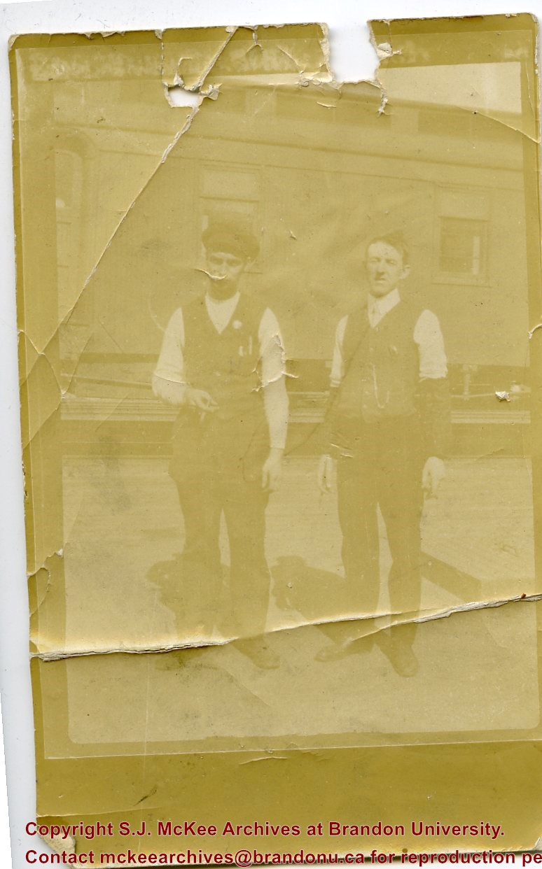
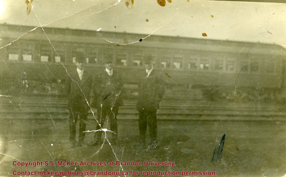
Photograph shows a group of men in suits and hats standing in a railway yard. A passenger train car is in the background. William Frederick McGuinness is standing on the left
Name Access
William Frederick McGuinness
W.F. McGuinness
Subject Access
trains
Storage Location
RG 5 photograph storage drawer 2 (hanging photos)
Arrangement
BR #3 Family pictures
Images
Show Less

Pacific Express in Kicking Horse Pass

http://archives.brandonu.ca/en/permalink/descriptions13870
Part Of
Fred McGuinness collection
Description Level
Item
GMD
graphic
Date Range
1889-1894
Accession Number
20-2009
Part Of
Fred McGuinness collection
Creator
Photographer: Trueman & Caple, Vancouver
Description Level
Item
Series Number
McG 9
Item Number
20-2009.180
Accession Number
20-2009
GMD
graphic
Date Range
1889-1894
Physical Description
3.75" x 2.5" (b/w)
Material Details
reproduction
Scope and Content
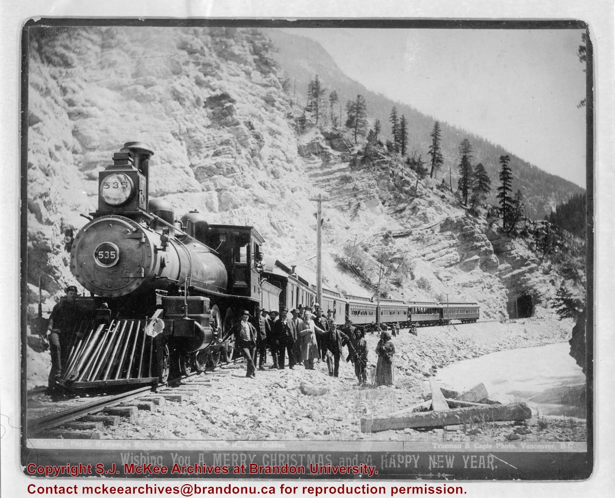
Photograph shows a possible CPR train stopped on the tracks at the base of a mountain. Train employees and passengers are posing alongside the train.
Notes
Writing on the front of the photograph reads: Train #1033 "Pacific Express" in Kicking Horse Pass near Golden / Trueman & Caple Photo, Vancouver, BC / Wishing You A Merry Christmas and a Happy New Year Date obtained from Margery Hadley McDougall, "R.H. Trueman, Artist and Documentarian," BC Studies, No. 52, Winter 1981-82, pp.129-141.
Subject Access
trains
Transportation
Storage Location
RG 5 photograph storage drawer 2 (hanging photos)
Arrangement
From 20-2009 #1 File 8
Images
Show Less

Album - yard at Brient

http://archives.brandonu.ca/en/permalink/descriptions14216
Part Of
Fred McGuinness collection
Description Level
Item
GMD
graphic
Date Range
[1900s]
Accession Number
1-2015
Part Of
Fred McGuinness collection
Description Level
Item
Series Number
McG 9
Item Number
1-2015.277.A8
Accession Number
1-2015
GMD
graphic
Date Range
[1900s]
Physical Description
4" x 2.5" (b/w)
Material Details
mounted in album
Physical Condition
Photo is warped
History / Biographical
Brient was a point along the Algoma Central Railway line that connected the Helen Mine to the Michipicoten Harbour. It is located southwest of Wawa, Ontario.
Scope and Content
Photograph shows ore box cars in a railway yard.
Notes
Writing beneath the photograph in the album reads: yard at Brient
Name Access
Brient, Ontario
Subject Access
mines
railways
Transportation
winter
Storage Location
1-2015 McG 1.4 Box 1 (in stacks, top shelf)
Images
Show Less

Album - Trembley iron ore cars

http://archives.brandonu.ca/en/permalink/descriptions14221
Part Of
Fred McGuinness collection
Description Level
Item
GMD
graphic
Date Range
[1900s]
Accession Number
1-2015
Part Of
Fred McGuinness collection
Description Level
Item
Series Number
McG 9
Item Number
1-2015.277.A13
Accession Number
1-2015
GMD
graphic
Date Range
[1900s]
Physical Description
4" x 2.5" (b/w)
Material Details
mounted in album
Physical Condition
Photo is warped
History / Biographical
Trembley was a point along the Algoma Central Railway line that connected the Helen Mine to the Michipicoten Harbour. It is located southwest of Wawa, Ontario.
Scope and Content
Photograph shows railroad tracks. A line of ore cars stretch along one track. Writing on the side of one of the cars (#3017) reads: Algoma Central Railway Co.
Notes
Writing beneath the photograph in the album reads: Trembley - Ore Cars
Name Access
Algoma Central Railway Co.
Subject Access
Railroad Transportation
railways
mines
Storage Location
1-2015 McG 1.4 Box 1 (in stacks, top shelf)
Images
Show Less

Album - Algoma Central and Hudson Bay Line

http://archives.brandonu.ca/en/permalink/descriptions14222
Part Of
Fred McGuinness collection
Description Level
Item
GMD
graphic
Date Range
[1900s]
Accession Number
1-2015
Part Of
Fred McGuinness collection
Description Level
Item
Series Number
McG 9
Item Number
1-2015.277.A14
Accession Number
1-2015
GMD
graphic
Date Range
[1900s]
Physical Description
4" x 2.5" (b/w)
Material Details
mounted in album
Physical Condition
Photo is warped
History / Biographical
In 1901, American entrepreneur Francis Hector Clergue (1856-1939) obtained the charter for the Ontario, Hudson Bay and Western Railway. Following his purchase, he reincoporated the Algoma Central Railway to the Algoma Central and Hudson's Bay Railway. (Source: Sault St. Mairie Public Library, "Transportation - Algoma Central Railway," Sault History Online, 2008)
Scope and Content
Photograph shows railroad tracks cutting through the Canadian Shield.
Notes
Writing beneath the photograph in the album reads: Algoma Central & Hundson Bay Ry.
Name Access
Algoma Central Railway Co.
Subject Access
Railroad Transportation
railways
mines
railroads
Storage Location
1-2015 McG 1.4 Box 1 (in stacks, top shelf)
Images
Show Less

Album - Lake Talbot Trestle

http://archives.brandonu.ca/en/permalink/descriptions14223
Part Of
Fred McGuinness collection
Description Level
Item
GMD
graphic
Date Range
[1900s]
Accession Number
1-2015
Part Of
Fred McGuinness collection
Description Level
Item
Series Number
McG 9
Item Number
1-2015.277.A15
Accession Number
1-2015
GMD
graphic
Date Range
[1900s]
Physical Description
4" x 2.5" (b/w)
Material Details
mounted in album
Physical Condition
Photo is warped
History / Biographical
The Lake Talbot tresle was a point along the Algoma Central Railway line that connected the Helen Mine to the Michipicoten Harbour. It is located north of Wawa and southwest of the Helen Mine.
Scope and Content
Photograph shows several men walking a railway line. Before them is a tresle bridge.
Notes
Writing beneath the photograph in the album reads: Lake Talbott Tresle [sic.]
Subject Access
Railroad Transportation
railways
mines
railroads
Storage Location
1-2015 McG 1.4 Box 1 (in stacks, top shelf)
Images
Show Less

Tenth Street looking towards CPR Station, Brandon, Man.

http://archives.brandonu.ca/en/permalink/descriptions13780
Part Of
Fred McGuinness collection
Description Level
Item
GMD
graphic
Date Range
[1917-1919]
Accession Number
20-2009
Part Of
Fred McGuinness collection
Description Level
Item
Series Number
McG 9
Item Number
20-2009.91
Accession Number
20-2009
GMD
graphic
Date Range
[1917-1919]
Physical Description
5.5" x 3.5" (colour)
Material Details
postcard
History / Biographical
According to Russ Gourluck (Silver Screens on the Prairie, Winnipeg: Great Plains Publications, 2012, 26), the Orpheum Theatre was in operation from 1917 to 1920 when it then became the Willis Theatre.
Scope and Content
Postcard shows the 100 block of 10th Street facing north. The CPR train station can be seen at the end of 10th Street. The sign for the Rex Cafe is visible on the west side of 10th Street. On the east side of 10th Street, billboards for Campbell & Campbell furniture are visible as well as signs for Pianos and the Orpheum Theatre. Motorists and cyclists share the road. Street car tracks run the length of 10th Street.
Notes
Postcard was manufactured by T.B. [Tichnor Brothers, Inc., 1908-1987] Cambridge, Massachusetts.
Name Access
10th Street
CPR Station
Orpheum Theatre
Rex Cafe
Campbell & Campbell
Brandon Municipal Railway
Subject Access
street scenes
building exteriors
store exteriors
automobiles
Transportation
street cars
bicycles
Storage Location
RG 5 photograph storage drawer 2 (hanging photos)
Images
Show Less

20 records – page 1 of 1.