Brient was a point along the Algoma Central Railway line that connected the Helen Mine to the Michipicoten Harbour. It is located southwest of Wawa, Ontario.
Scope and Content
Photograph shows ore box cars in a railway yard.
Notes
Writing beneath the photograph in the album reads: yard at Brient
Trembley was a point along the Algoma Central Railway line that connected the Helen Mine to the Michipicoten Harbour. It is located southwest of Wawa, Ontario.
Scope and Content
Photograph shows railroad tracks. A line of ore cars stretch along one track. Writing on the side of one of the cars (#3017) reads: Algoma Central Railway Co.
Notes
Writing beneath the photograph in the album reads: Trembley - Ore Cars
Brient was a point along the Algoma Central Railway line that connected the Helen Mine to the Michipicoten Harbour. It is located southwest of Wawa, Ontario.
Scope and Content
Photograph shows several men standing on railway tracks before a wood-framed train station in the winter. A sign attached to the station reads: British American Express Co. The man in the foreground appears to have a mailbag over on his back and several newspapers tucked beneath his arm.
Notes
Writing beneath the photograph in the album reads: station at Brient
In 1901, American entrepreneur Francis Hector Clergue (1856-1939) obtained the charter for the Ontario, Hudson Bay and Western Railway. Following his purchase, he reincoporated the Algoma Central Railway to the Algoma Central and Hudson's Bay Railway. (Source: Sault St. Mairie Public Library, "Transportation - Algoma Central Railway," Sault History Online, 2008)
Scope and Content
Photograph shows railroad tracks cutting through the Canadian Shield.
Notes
Writing beneath the photograph in the album reads: Algoma Central & Hundson Bay Ry.
The Lake Talbot tresle was a point along the Algoma Central Railway line that connected the Helen Mine to the Michipicoten Harbour. It is located north of Wawa and southwest of the Helen Mine.
Scope and Content
Photograph shows several men walking a railway line. Before them is a tresle bridge.
Notes
Writing beneath the photograph in the album reads: Lake Talbott Tresle [sic.]
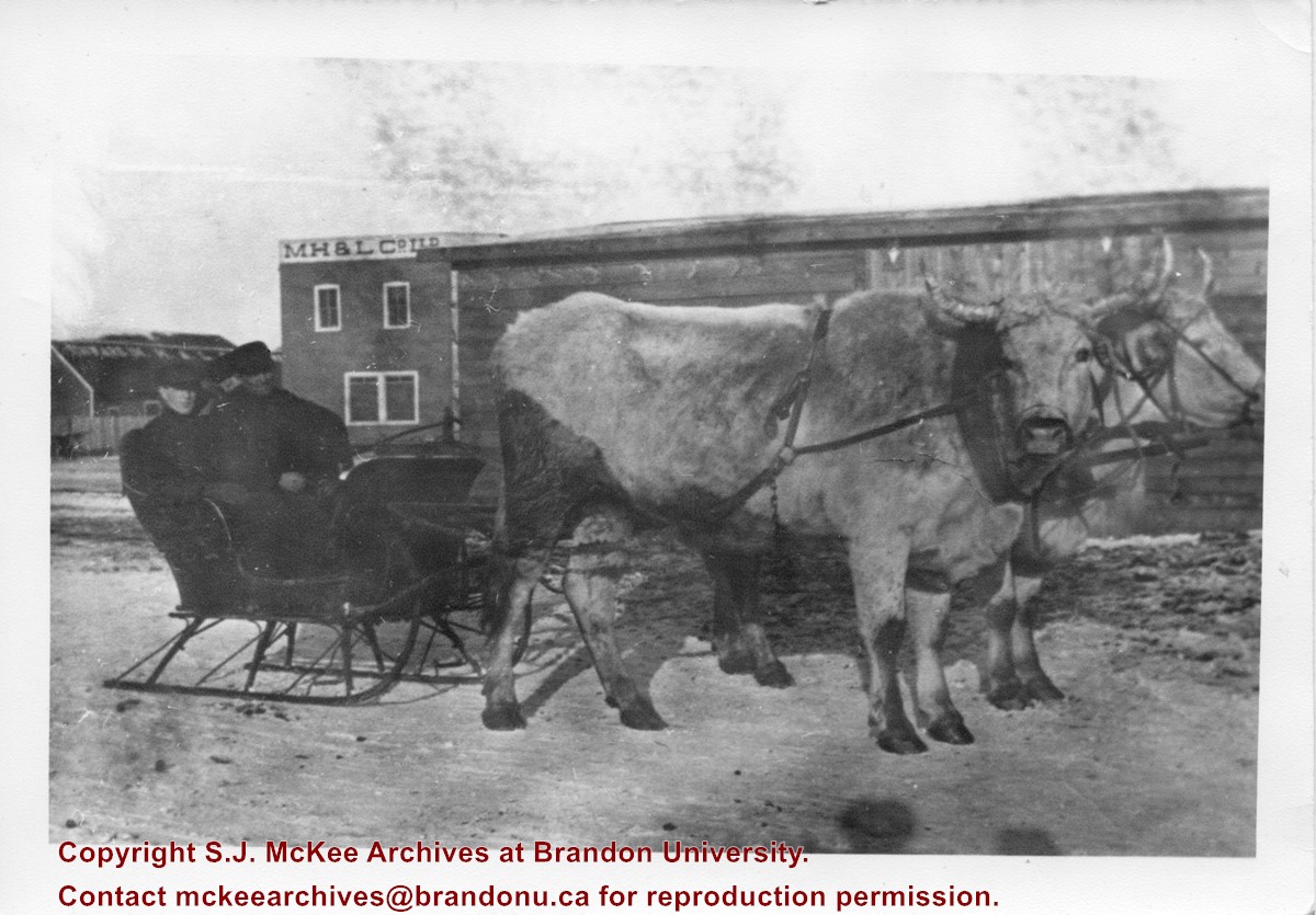
Given to Fred McGuinness by George Creighton, 1980?
Scope and Content
Photograph shows two men seated in a sleigh pulled by two oxen. Behind the men is a wooden building with a M.H. & L Co. Ltd. sign on its side.
Notes
Writing on the front of the photograph reads: 7.3.80. file family letters. picture of dad's store at Hamiota. M.H.& L. > Manitoba Hardware & Lumber Co. George Creighton gave me this. McG.
Photograph shows the Brandon Wheat Market along Pacific Avenue on November 30, 1885. Farmers can be seen driving wagon teams loaded with bags of grain in line on Pacific Avenue from 10 Street to at least 7th Street. On the north side of Pacific Avenue the CPR Land Office and grain elevators are pictured. On the south side of Pacific Avenue, the general merchant/hardware store Bower, Blackburn, Mundell & Porter is situated on the corner of Pacific Avenue and 10th Street. A 10th Street sign is affixed to the merchants' store. On the east side of the general store, Edie House, the Grand View Hotel, and a Farmers' boarding and lodging house can be seen. Most of the buildings appear to be woodframed except for the Grand View, which is constructed of brick. Sidewalks appear to be in place on the south side of Pacific and snow dusts the streets. A baby swathed in winter clothing sits in a pram/baby carriage in front of the general store.
Notes
Writing on the front of the photograph reads: Novemeber 30th, 1885, Brandon Wheat Market
Photograph shows a panorama, bird's-eye-view of downtown Brandon, between Pacific and Rosser Avenues and 7th Street facing east. Photoraph likely taken from the McKenzie Seeds Building. Visible businesses include: Western Canada Flour Mills, Hanbury Hardware Co. Ltd., Cockshutt Plow Co., New Pacific Hotel, Gordon McKay Building, and Arlington Hotel.
Notes
Part of "Souvenir of Brandon, Manitoba, Canada [viewbook], Printed by Photogelatine Engraving Co. Limited, Ottawa." Dates obtained from the Burchill's Music Store Henderson's Brandon City Directory listings (1927-1929). Writing on the front of the photograph reads: Panorama of Brandon, Man.
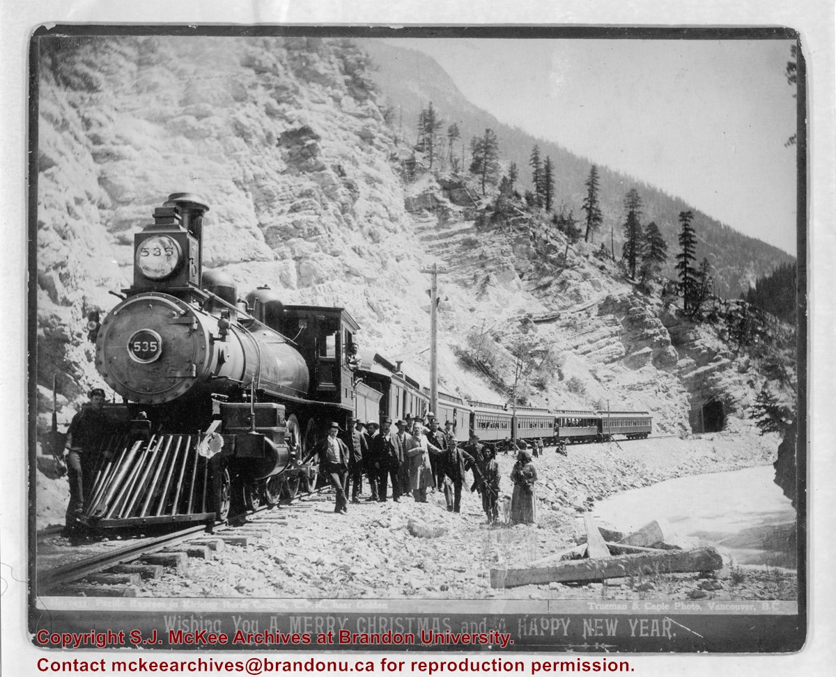
Photograph shows a possible CPR train stopped on the tracks at the base of a mountain. Train employees and passengers are posing alongside the train.
Notes
Writing on the front of the photograph reads: Train #1033 "Pacific Express" in Kicking Horse Pass near Golden / Trueman & Caple Photo, Vancouver, BC / Wishing You A Merry Christmas and a Happy New Year
Date obtained from Margery Hadley McDougall, "R.H. Trueman, Artist and Documentarian," BC Studies, No. 52, Winter 1981-82, pp.129-141.
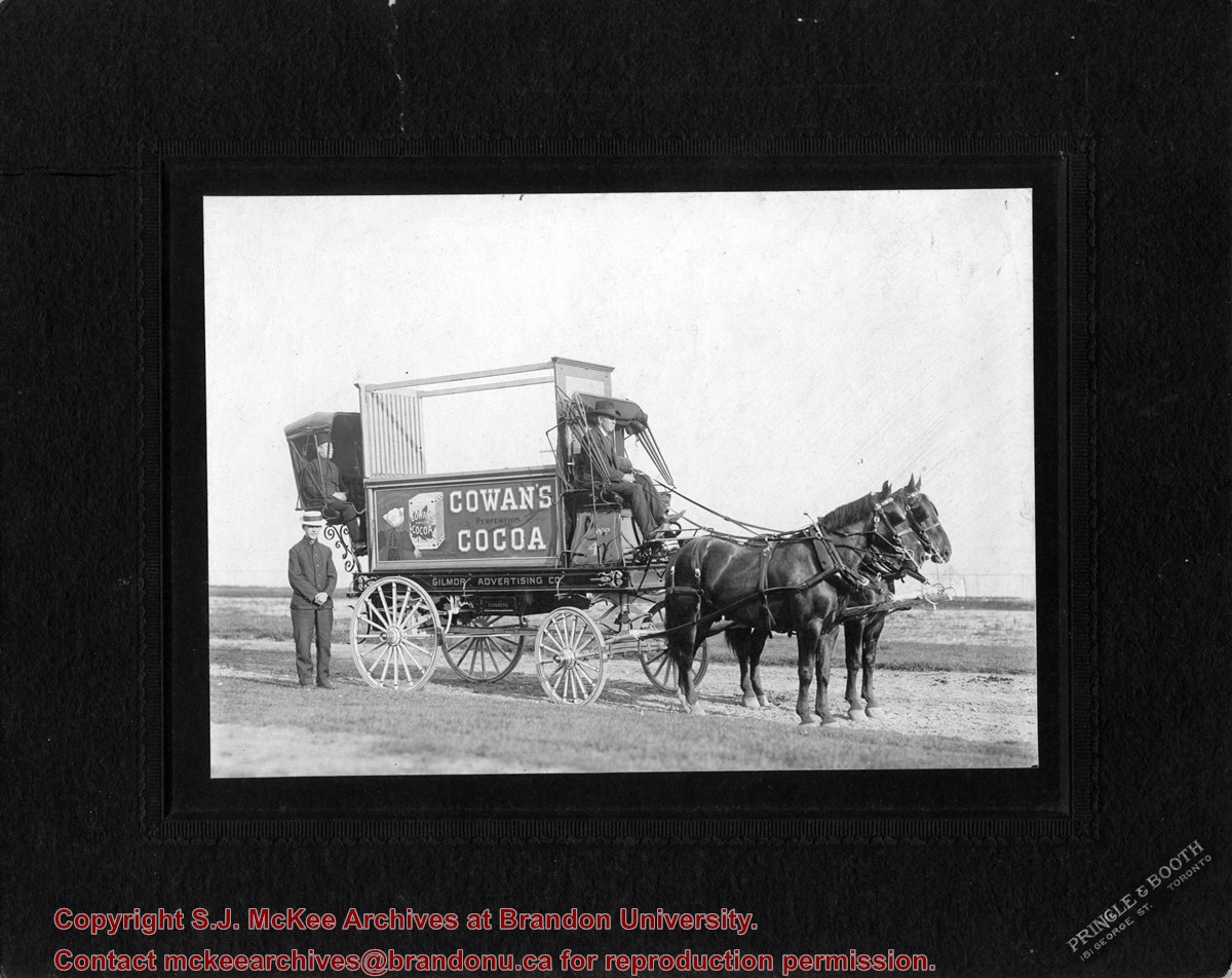
Photograph was in possession of Mrs. Ruby Miles, who passed the image on to Fred McGuinness. McGuinness makes reference to Mrs. Miles and this photograph in his Sunbeams column (Brandon Sun 14 September 1978).
Scope and Content
Photograph shows a horse drawn wagon advertising Cowan's Cocoa. The Gilmore Advertising Company of Toronto appears to be responsible for the ad and the wagon is numbered "No.4". Three men appear in the photograph: one behind the reigns, one in the rear seat of the wagon, and other standing at the rear axel.
Notes
Writing on the front of the photograph matting reads: Pringle & Booth, 181 George Street, Toronto. Writing on the back of the photograph matting reads: Mrs. R. Miles, R.J. Brdgdon?, Right Side 2.50 a day.
Date obtained from http://photographersofontario.ca
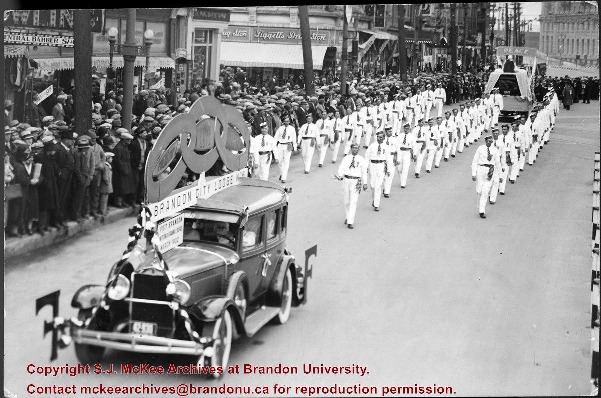
Photograph shows members of the Independent Order of Odd Fellows (IOOF) Brandon City Lodge No.6 parading down a street, possibly Portage Avenue in Winnipeg. Spectators line the street. Visible storefronts include: Central Barber Shop, The Royal Bank of Canada, and Liggetts Drug Store.
Notes
Back of photograph is stamped: The Star Photo Studio, 490 Main Street, Winnipeg, Sep 23, 1931
The International Peace Garden is situated on the international border between Manitoba and North Dakota, adjacent to the Canadian Border Services Boissevain port of entry and the U.S. Customs and Border Protection Agency's Dunseith port of entry. The dedication for the International Peace Garden was held on July 14, 1932. It was estimated that 50,000 people were in attendance on opening day. The park is 9.5-square kilometers or 3.54-square miles.
Custodial History
Pictures were sent to Fred McGuinness in 1970 from E.M. Bergson of Brandon.
Scope and Content
Photograph shows the crowded parking lot at the International Peace Garden's 1932 dedication ceremony. People mill amongst the automobiles and tents can be seen in the background.
Notes
The back of the photograph is stamped: Enameloid Velox Print by the Jul 27 1932, Chicago Postal Photo Supplies, Regina, Sask.


)
)
)
)