Brient was a point along the Algoma Central Railway line that connected the Helen Mine to the Michipicoten Harbour. It is located southwest of Wawa, Ontario.
Scope and Content
Photograph shows several men standing on railway tracks before a wood-framed train station in the winter. A sign attached to the station reads: British American Express Co. The man in the foreground appears to have a mailbag over on his back and several newspapers tucked beneath his arm.
Notes
Writing beneath the photograph in the album reads: station at Brient
Postcard shows a street scene of Donald Street looking south from the Portage Avenue Intersection.
Notes
Writing on the back of the postcard reads: Aug 9, Dear ruth, Aunt Eva, Aunt Annie and Fred were over to the bowlnig greens tonight. Every one fine. Doddy. Postcard is addressed to Ruth McGuinness, 337-17th St., Brandon, Man. Postmarked: Winnipeg 12 PM Aug 10 1927 Man.
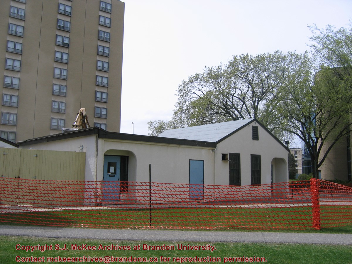
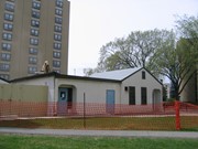
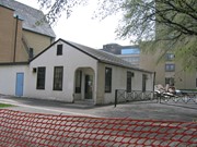
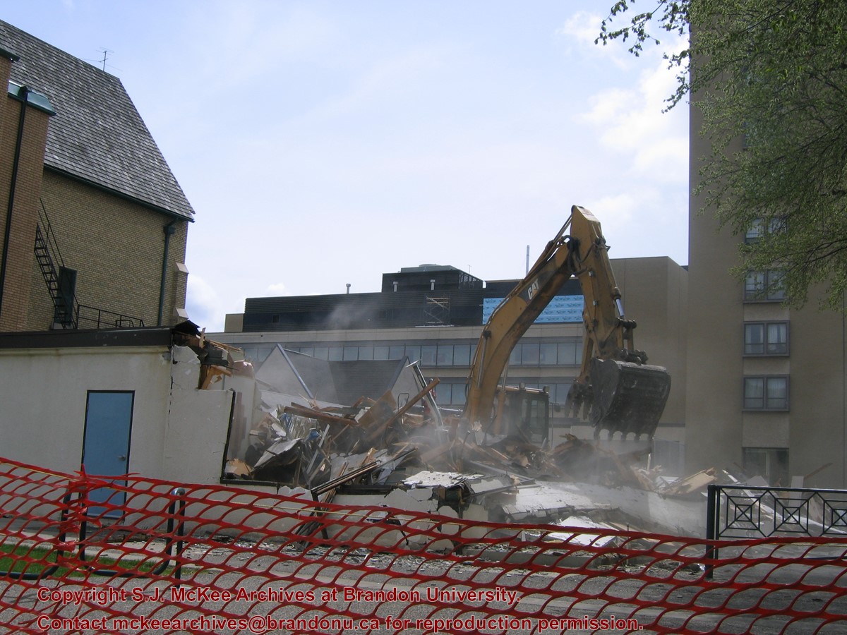
Located at the centre of the Brandon University campus, the Physical Plant H-Hut was destroyed following the opening of the new $3.9M, 13,600 square-foot physical plant on 07 April 2010.
Custodial History
Photograph was taken by McKee Archives project archivist Jill Sutherland.
Scope and Content
Photograph shows the demolition of the Physical Plant H-Hut.
Located at the centre of the Brandon University campus, the Physical Plant H-Hut was destroyed following the opening of the new $3.9M, 13,600 square-foot physical plant on 07 April 2010.
Custodial History
Photograph was taken by McKee Archives project archivist Jill Sutherland.
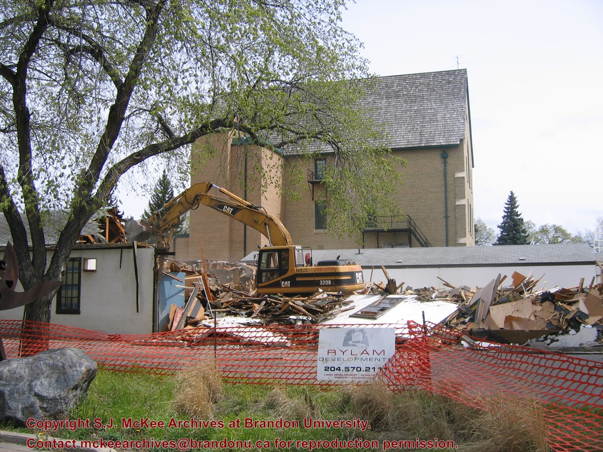
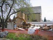
Scope and Content
Photograph shows the demolition of the Physical Plant H-Hut. A sign for Rylam Development is visible on the snow fence fencing off the demolition site.
Located at the centre of the Brandon University campus, the Physical Plant H-Hut was destroyed following the opening of the new $3.9M, 13,600 square-foot physical plant on 07 April 2010.
Custodial History
Photograph was taken by McKee Archives project archivist Jill Sutherland.
Scope and Content
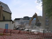
Photograph shows the demolition of the Physical Plant H-Hut. The photograph is looking northeast from the steps of Harvest Hall. The Citizens' Science Centre (BUSU Building) is visible in the background.
Located at the centre of the Brandon University campus, the Physical Plant H-Hut was destroyed following the opening of the new $3.9M, 13,600 square-foot physical plant on 07 April 2010.
Custodial History
Photograph was taken by McKee Archives project archivist Jill Sutherland.
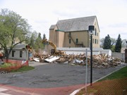
Scope and Content
Photograph shows the demolition of the Physical Plant H-Hut. The photograph is looking northeast.
Located at the centre of the Brandon University campus, the Physical Plant H-Hut was destroyed following the opening of the new $3.9M, 13,600 square-foot physical plant on 07 April 2010.
Custodial History
Photograph was taken by McKee Archives project archivist Jill Sutherland.
Scope and Content
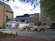
Photograph shows the demolition of the Physical Plant H-Hut. The photograph is looking south/southeast.
Located at the centre of the Brandon University campus, the Physical Plant H-Hut was destroyed following the opening of the new $3.9M, 13,600 square-foot physical plant on 07 April 2010.
Custodial History
Photograph was taken by McKee Archives project archivist Jill Sutherland.
Scope and Content
Photograph shows the demolition of the Physical Plant H-Hut. The photograph is looking south/southeast.
Located at the centre of the Brandon University campus, the Physical Plant H-Hut was destroyed following the opening of the new $3.9M, 13,600 square-foot physical plant on 07 April 2010.
Custodial History
Photograph was taken by McKee Archives project archivist Jill Sutherland.
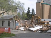
Scope and Content
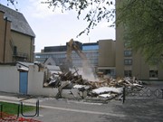
Photograph shows the demolition of the Physical Plant H-Hut. The photograph is looking southeast. The John R. Brodie Science Centre, the Geology H-Hut, and portions of the Citizens' Science Building (BUSU Building), Knowles-Douglas expansion (KDC) and McMaster Hall are visible in the background.
Photograph shows the train station at the port of Mulgrave, Nova Scotia. Possibly the site where the HMCS Alachasse was docked when Fred McGuinness was a telegraphers in the Canadian Navy.
Notes
Writing on the back of the postcard reads: AZO post card
Brient was a point along the Algoma Central Railway line that connected the Helen Mine to the Michipicoten Harbour. It is located southwest of Wawa, Ontario.
Scope and Content
Photograph shows ore box cars in a railway yard.
Notes
Writing beneath the photograph in the album reads: yard at Brient
Trembley was a point along the Algoma Central Railway line that connected the Helen Mine to the Michipicoten Harbour. It is located southwest of Wawa, Ontario.
Scope and Content
Photograph shows railroad tracks. A line of ore cars stretch along one track. Writing on the side of one of the cars (#3017) reads: Algoma Central Railway Co.
Notes
Writing beneath the photograph in the album reads: Trembley - Ore Cars
Photograph shows the CPR Train Station on Pacific Avenue and 10th Street.
Notes
Part of "Souvenir of Brandon, Manitoba, Canada [viewbook], Printed by Photogelatine Engraving Co. Limited, Ottawa." Dates obtained from the Burchill's Music Store Henderson's Brandon City Directory listings (1927-1929). Writing on the front of the photograph reads: CPR Station, Brandon, Man.
Photograph shows a southwest view of the Prince Edward Hotel and train station.
Notes
Part of "Souvenir of Brandon, Manitoba, Canada [viewbook], Printed by Photogelatine Engraving Co. Limited, Ottawa." Dates obtained from the Burchill's Music Store Henderson's Brandon City Directory listings (1927-1929). Writing on the front of the photograph reads: Prince Edward Hotel, Brandon, Man.
In 1901, American entrepreneur Francis Hector Clergue (1856-1939) obtained the charter for the Ontario, Hudson Bay and Western Railway. Following his purchase, he reincoporated the Algoma Central Railway to the Algoma Central and Hudson's Bay Railway. (Source: Sault St. Mairie Public Library, "Transportation - Algoma Central Railway," Sault History Online, 2008)
Scope and Content
Photograph shows railroad tracks cutting through the Canadian Shield.
Notes
Writing beneath the photograph in the album reads: Algoma Central & Hundson Bay Ry.
The Lake Talbot tresle was a point along the Algoma Central Railway line that connected the Helen Mine to the Michipicoten Harbour. It is located north of Wawa and southwest of the Helen Mine.
Scope and Content
Photograph shows several men walking a railway line. Before them is a tresle bridge.
Notes
Writing beneath the photograph in the album reads: Lake Talbott Tresle [sic.]
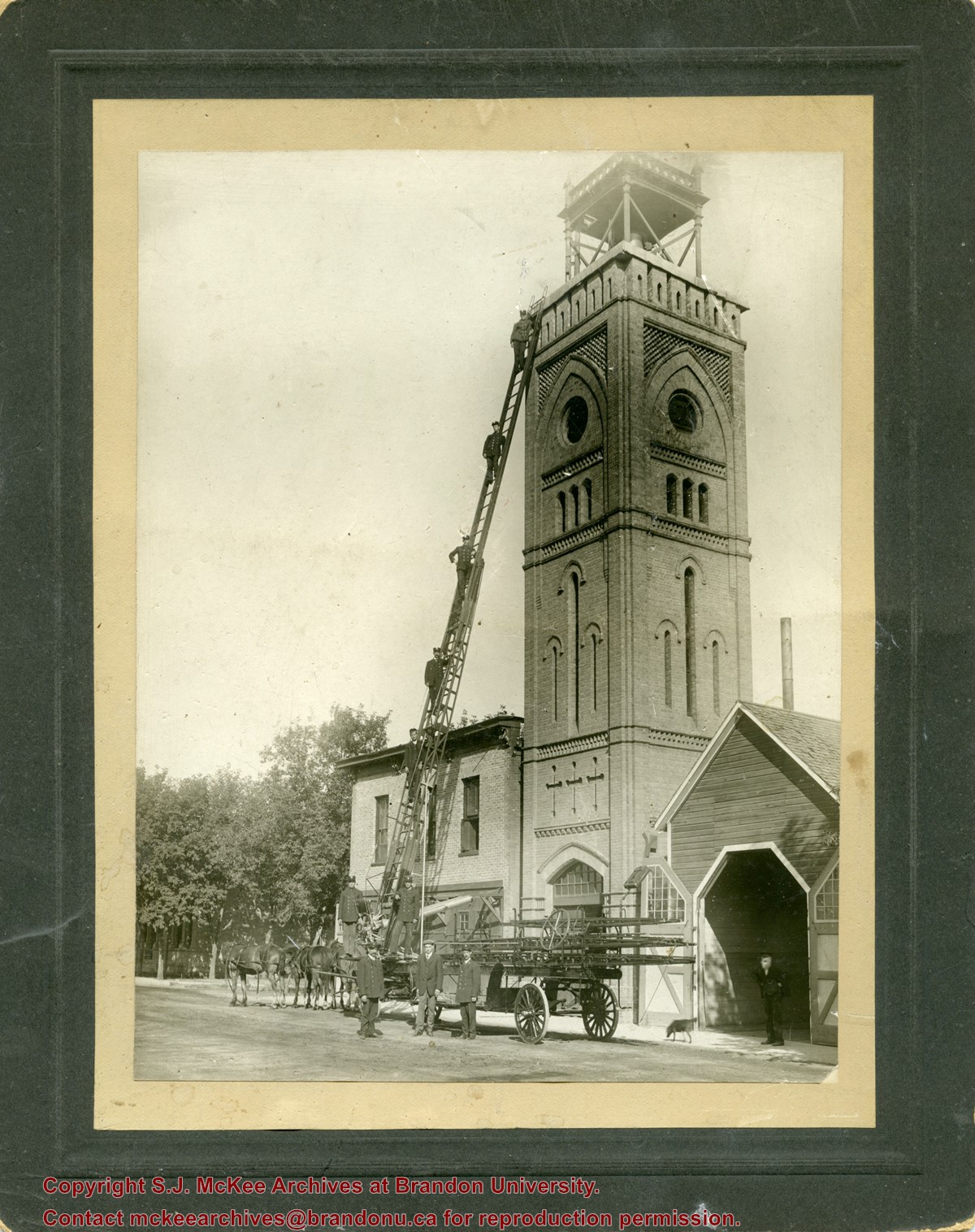
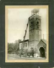
The Original Brandon Fire Hall was located on the east half of the north side of the 600-block of Princess Avenue. The hall was in operation from 1884 to 1911.
Scope and Content
Photograph shows Brandon's first fire hall on Princess Avenue. The hose tower and stable are visible. The horse-drawn ladder wagon is parked on the street in front of the hall and the rescue ladder is extended against the tower. Five firefighters are standing on the ladder and two are standing at its base.
Notes
Writing on the back of the photograph reads: Mrs. E. Harden, 6th Street


