Pages 1-9 consist of Field Director, Bev Nicholson's field journal. Pages contain information about the site in general and coordinates for the survey.
The Medicine Hat Exhibition and Stampede Parade Day was held on Thursday, July 19, 1962, at 9:30 a.m. The local newspaper reported that approximately 24,000 people were in attendance to see parade marshall Rod Ashburner leading 175 entries consisting of 90 floats, 75 horses, and 10 bands. There were 19 parade categories eligible for $12,000 in prize money and included: junior and senior cowboys and cowgirls; fancy and Shetland ponies; sulky class open; comic, commercial, industrial and organizational floats; decorated cars; special ranch class; 4-H Clubs; and a non-competitive class.
The parade route started at Second St. and Allowance Ave., from Second St. to Ash Ave., north on Ash to First St. SE., from First St. S.E. to Fourth Ave., south to Second St. to South Railway St., south on South Railway St. to Third St., with a finish at McLeod Trail. A route map was published in the Medicine Hat News the day before the parade.
Aerial photographs of the parade were taken by Medicine Hat News photographer Howard Heid (1930-2005) from the private helicopter of John Bourn. Bourn was a pilot from Woodville, Wisconsin, who chartered his four-seater helicopter for sight-seers at exhibitions and stampedes across the county.
(Sources: Pat Currie, "Let 'Er Go!," Medicine Hat News, 19 July 1962,1; Harald Gunderson, "'Eye in the Sky' Best Parade View," Medicine Hat News, 19 July 1962,1; "Parade Starts at 9:30 Sharp," 18 July 1962)
Scope and Content
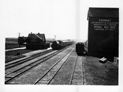
Photograph shows an aerial view of the Medicine Hat Exhibition and Stampede Parade route with a focus on the First Street SE. A number of gas stations and garages are visible along this route and include Texaco, Shell, Ford, and B/A. The Fraternal Order of Eagles lodge is also visible.
Notes
This photograph appeared on the front page of The Medicine Hat News (19 July 1962).
This box contains general circulars sent out by the MPE central office to the local ssociations. The records include the following:
18. General Circulars 1944
19. General Circulars 1945
20. General Circulars 1946
21. General Circulars 1947
22. General Circulars 1948
23. General Circulars 1949
24. General Circulars 1950
25. General Circulars 1951
26. General Circulars 1952
27. General Circulars 1953
28. General Circulars 1954
29. General Circulars 1955
30. General Circulars 1956
31. General Circulars 1957
Co-op Farm Implements was a subsidiary company designed to serve Pool members in Manitoba and Saskatchewan.
See also fonds level description of RG 4 for history/bio of MPE
Scope and Content
This sub-series consists of general documents and photographs.
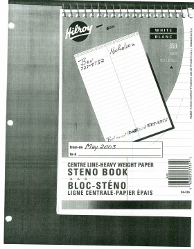
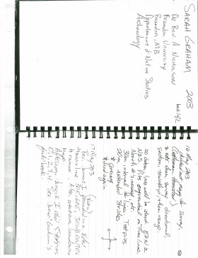
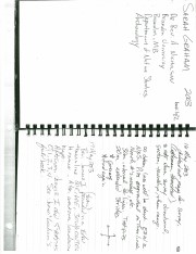
Archaeological testing began in the Crepeele locale in May 2003. The Casselman survey in the Crepeele locale was directed by Bev Nicholson and James Graham supervised the crew. Crew members were Sarah Graham, Jollana Bishop, Lisa Sonnenburg, Todd Kristensen, Michael Evans, and Emily Ansell.
Scope and Content
The director, field supervisor and some field crew kept daily journals of activities during the survey including: excavation methods, items recovered, features, local environment and weather are noted.
Field journals were scanned in their entirety as one multi-page PDF. However, each journal may contain information that relates to multiple sites or individuals. The entire PDF journal is linked to each file level description with the relevant page numbers indicated in the Scope and Content note.
Box contains unbound Manitoba Pool Elevators central office meeting minutes including MPE Board of Directors minutes January 15-16,1985 to July 17,1996.
This box contains minutes from meeting of MPE district advisory committees. The records include the following:
55. District Advisory Committee 1102 2000-2001
56. District Advisory Committee 1103 2000-2001
57. District Advisory Committee 1104 2000-2001
58. District Advisory Committee 1005 1999-2001
59. District Advisory Committee 1006 2000-2001
60. District Advisory Committee 1007 1999-2001
61. District Advisory Committee 1008 1999-2001
62. District Advisory Committee 1001 1999-2001
63. District Advisory Committee 1002 2000-2001
64. District Advisory Committee 1003 Apr., July 2000
65. District Advisory Committee 1004 1999-2000
66. District Advisory Committee 906 2000-2001
67. District Advisory Committee 907 2000-2001
68. District Advisory Committee 908 2000-2001
69. District Advisory Committee 901 2000-2001
70. District Advisory Committee 902 2000-2001
71. District Advisory Committee 903 April 12 2000
72. District Advisory Committee 904 2000-2001
73. District Advisory Committee 805 1999-2000
74. District Advisory Committee 806 July 7 2000
75. District Advisory Committee 807 July 7 2000
76. District Advisory Committee 801 2000-2001
77. District Advisory Committee 802 2000-2001
78. District Advisory Committee 803 Nov 14 1999
79. District Advisory Committee 804 2000-2001
80. District Advisory Committee 705 March 15 2000
81. District Advisory Committee 708 March 14 2000
82. District Advisory Committee 707 March 15 2000
83. District Advisory Committee 606 (Miscellaneous)
Periodicals section as equipped in the early 1970's. Basement Floor, MacKenzie. Tour of Robbins Library by members of St. Mary's Roman (sic) Catholic Church – associated with a gift of funds to the Library
See collection level description for Custodial History.
Scope and Content
Item consists of: Sq. C. Winnipeg, Man. 1st hammer #4 time mark 23 February 1898. Also Sq. C. Morden, Man. 8 March 1898, Return to and two Not Called for impressions. Reverse Sq. C. Morden, Man. 25 February 1898 and Winnipeg circle #6, 1 March 1898.
The high biodiversity and evidence of pre-Europeon contact prompted the decision to test the Crepeele locale. The survey was named in recognition of the Casselman family, the original landowners.
Archaeological testing began in the Crepeele locale in May 2003 on property now owned by the Crepeele family. The locale covers over 6 sections or approximately 3,800 acres of land in an area of stabilized sand dunes and wetlands covered with mixed forest and prairie grass. Given the terrain, the size of the crew and time constrains, an area of approximately 60 acres was chosen for the survey. The survey used the established archaeological methodology of walking the selected area and using a shovel test surveyed grid. The use of GIS technology to locate the exact test spot and record the information into a GIS database was a significant advance and was one of the advantages of the integration of multi-disciplinary techniques encouraged by the SCAPE project. Over one half of the test pits resulted in the recovery of cultural materials. The results of the Casselman survey indicated several areas for further examination including areas that became the Crepeele, Sarah and Graham sites.
Scope and Content
Sub sub series has been divided into five sub sub sub series including: (1) Summary information; (2) Field journals; (3) Site records; (4) Artifact catalogues; and (5) Photographs.


