Skip header and navigation

Revise Search

20 records – page 1 of 1.

4th Troop - "B squadron" 1st Canadian Mounted Rifles overseas force

http://archives.brandonu.ca/en/permalink/descriptions10127
Part Of
RG 12 Brandon and Area Photograph Collection
Description Level
Item
GMD
graphic
Date Range
February 8, 1915
Accession Number
1-1999
Part Of
RG 12 Brandon and Area Photograph Collection
Creator
Photographer: Creelman & Roberts
Description Level
Item
Series Number
2
Item Number
BAPC 2.14
Accession Number
1-1999
GMD
graphic
Date Range
February 8, 1915
Physical Description
7.5" x 9.5" (b/w)
Material Details
On matting
Scope and Content
Photograph is a portrait of the 4th Troop - "B squadron" 1st Canadian Mounted Rifles overseas force taken in the Brandon Arena.
Name Access
Brandon Arena
World War I
First World War
Great War
Canadian Expiditionary Forces
Canadian Mounted Rifles
Wheat City Arena
Subject Access
armed forces
Storage Location
BAPC oversize storage drawer
Images
Show Less
Part Of
RG 12 Brandon and Area Photograph Collection
Description Level
Item
GMD
multiple media
Date Range
1916
Part Of
RG 12 Brandon and Area Photograph Collection
Description Level
Item
Series Number
1
Item Number
BAPC 1.6
GMD
multiple media
Date Range
1916
Publication
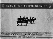
Published by Western News Agency Ltd., Winnipeg, (46 pp.)
Physical Description
9.25" x 6.75" (b/w)
Material Details
Small pamphlet containing photo essay
History / Biographical
Established as Sewell Camp in 1909, it was renamed after Major-General Sir Sam Hughes, Canada's Minister of Militia and Defence, in 1915. During World War I (1914–1918), more than 38,000 troops of the Canadian Expeditionary Force trained there. Many of the soldiers later distinguished themselves at the battle of Vimy Ridge, in April 1917. Extensive trench systems, grenade and rifle ranges, and military structures were built in 1915 and 1916. A variety of retail stores on a double-avenued area close to the main camp formed a lively commercial midway. Camp Hughes was dismantled in the 1930s as part of an unemployment relief project. The Camp Hughes Military Training Site, located at NE 34-10-16 W, 10 kms west of Carberry, R.M. of North Cypress, was designated Manitoba Provincial Heritage Site No. 82 on April 18, 1994.
Custodial History
Donated by Earl Johnson, publisher of the Baldur Gazette, through the "good offices" of Fred McGuinness.
Scope and Content
Item is a small pamphlet containing 50 black & white photographs in a photo essay entitled: Ready for Active Service, Camp Hughes Manitoba.
Notes
McGuinness wrote about Camp Hughes and how he acquired the pamphlet in a Viewpoint column in the November 1, 2001 edition of the Brandon Sun. A copy of the article is with the pamphlet. History/Bio information taken from the Manitoba Government Exlpore Our Heritage Website at: http://www.gov.mb.ca/chc/hrb/prov/p082.html (December 14, 2009).
Name Access
World War I
First World War
Great War
Canadian Expiditionary Force
Major D.A. Ross
Major-General John Hughes
Major J.W. Sifton
Subject Access
military personnel
armed forces
military training
trench warfare
Storage Location
BAPC photograph drawer
Images
Show Less

World War I soldiers march down Rosser Avenue

http://archives.brandonu.ca/en/permalink/descriptions10125
Part Of
RG 12 Brandon and Area Photograph Collection
Description Level
Item
GMD
graphic
Date Range
c. 1914
Accession Number
24-1999
Part Of
RG 12 Brandon and Area Photograph Collection
Description Level
Item
Series Number
2
Item Number
BAPC 2.12
Accession Number
24-1999
GMD
graphic
Date Range
c. 1914
Physical Description
7.5" x 9.5" (b/w)
Physical Condition
There are two burn holes and many areas where the emulsion layer is gone.
History / Biographical
John A. McDonald's was a men's and boyswear store in operation for several decades at 841 Rosser Avenue, Brandon, MB.
Scope and Content
Photograph of soldiers marching west on Rosser Avenue.
Name Access
John A. McDonald's
Diamond Hall
W.E. Crawford
The Patricia
World War I
First World War
Great War
Rosser Avenue
Subject Access
public ceremonies
armed forces
military personnel
parades
downtown
cityscapes
Storage Location
BAPC photograph drawer
Images
Show Less

City of Brandon parade float

http://archives.brandonu.ca/en/permalink/descriptions10118
Part Of
RG 12 Brandon and Area Photograph Collection
Description Level
Item
GMD
graphic
Date Range
October 1980
Part Of
RG 12 Brandon and Area Photograph Collection
Description Level
Item
Series Number
2
Item Number
BAPC 2.5
GMD
graphic
Date Range
October 1980
Physical Description
3.5" x 4.5" (color)
Scope and Content
Photograph of the City of Brandon float advertising Brandon's Centennial in 1982.
Name Access
City of Brandon
Subject Access
centennials
parades
floats
public ceremonies
Storage Location
BAPC photograph drawer
Images
Show Less

Wheat City Business College hockey team

http://archives.brandonu.ca/en/permalink/descriptions14339
Part Of
RG 12 Brandon and Area Photograph Collection
Description Level
Item
GMD
graphic
Date Range
1920
Part Of
RG 12 Brandon and Area Photograph Collection
Creator
Photographer: Davidson Studio
Description Level
Item
Series Number
7
Item Number
BAPC 7.3
GMD
graphic
Date Range
1920
Physical Description
19" x 15.5" (b/w)
Material Details
On board
Physical Condition
Backing board is warped and has two large tears on the back. There is foxing on the image and board on the front
Custodial History
Image was donated to the McKee Archives in 2020 by Don Smith, Associate Curator/Manager of the Cornwall Community Museum/SD&G Historical Society and a volunteer with the City of Cornwall's Heritage Cornwall Committee. Smith was asked by a local used bookstore owner to find a home for a box of items they had acquired from the new owner of a Lancaster, ON are antique/collectibles operation.
Scope and Content
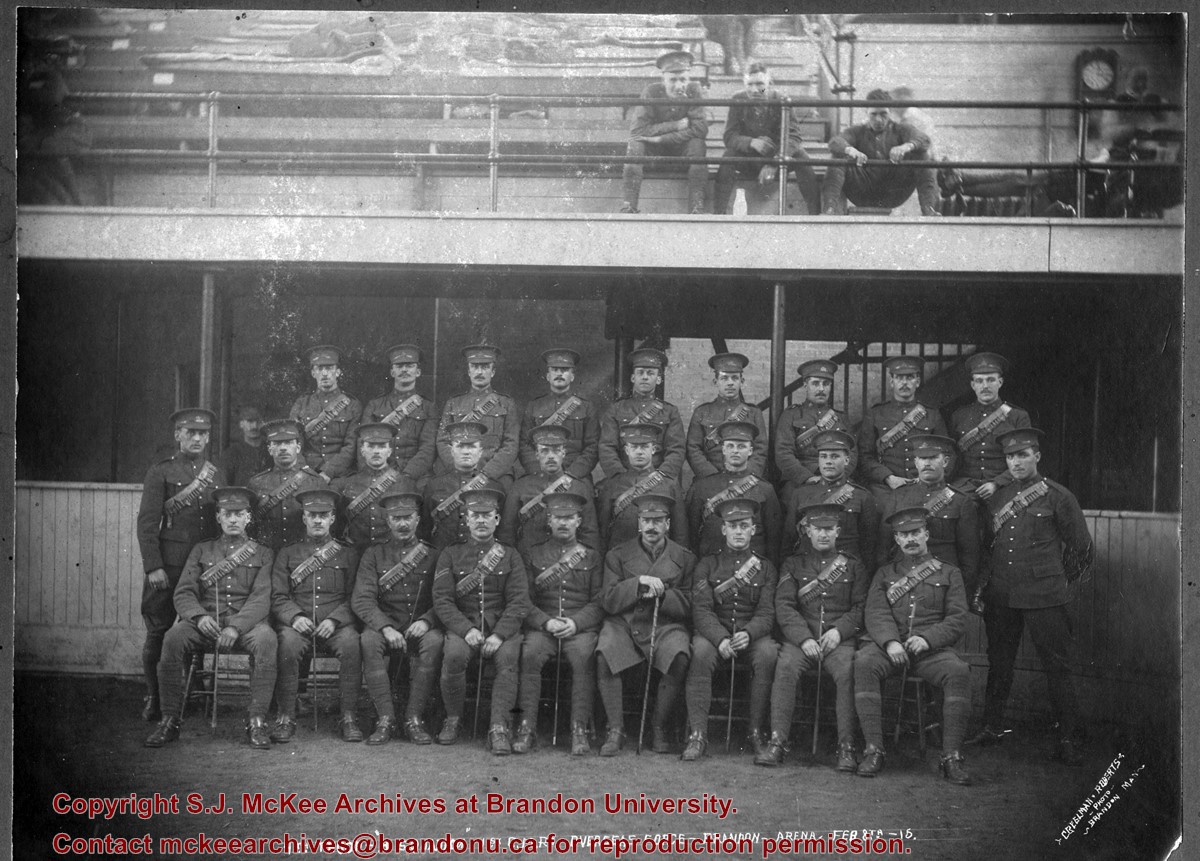
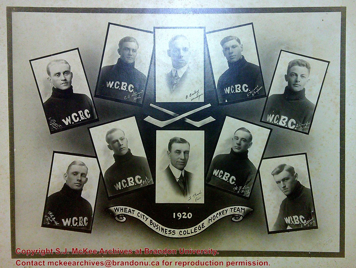
Composite portrait of the players, manager and president of the Wheat City Business College hockey team. The name and position/role of each man is written in the bottom right corner of their portrait.
Name Access
Wheat City Business College
C. Stewart
C.A. Stewart
B. Bailey
L. Crawford
F. Wood
W.J. Lee
W.A. Dodd
Subject Access
sports
Hockey
Storage Location
BAPC oversize storage drawer
Images
Show Less
Part Of
RG 12 Brandon and Area Photograph Collection
Description Level
Item
GMD
graphic
Date Range
1922
Part Of
RG 12 Brandon and Area Photograph Collection
Creator
Photographer: H.H. Allen
Description Level
Item
Series Number
2
Item Number
BAPC 2.24
GMD
graphic
Date Range
1922
Physical Description
9.5" x 7.5" (b/w)
Material Details
On matting
Physical Condition
Some spotting on the image
History / Biographical
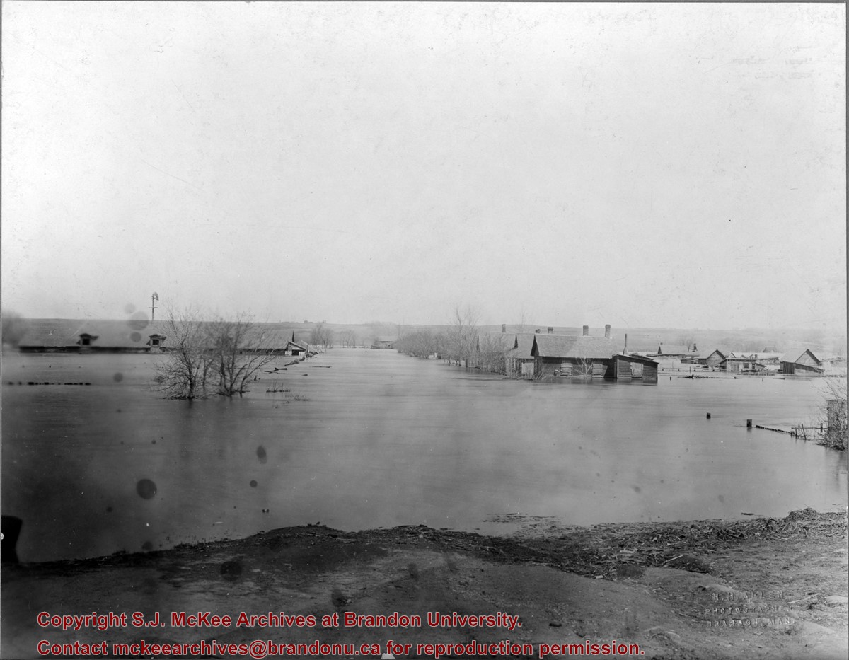
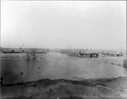
The "flats" refers to the Assiniboine River floodplane from 18th Street to First Street on either side of the river. See p. 223 of G.F. Barker's Brandon: A City for a description of the 1922 flood.
Custodial History
The photo was owned by Mrs. Wes Railton prior to its donation to the Archives.
Scope and Content
Photograph contains an image of houses on the Assiboine floodplane (Brandon's "flats") submerged in flood-waters.
Name Access
Brandon
Assiniboine River
Subject Access
northend
floods
natural phenomena
Storage Location
BAPC oversize storage drawer
Images
Show Less
Part Of
RG 12 Brandon and Area Photograph Collection
Description Level
Item
GMD
graphic
Date Range
[after 1937]
Part Of
RG 12 Brandon and Area Photograph Collection
Description Level
Item
Series Number
2
Item Number
BAPC 2.25
GMD
graphic
Date Range
[after 1937]
Physical Description
4" x 2.5" (b/w)
History / Biographical
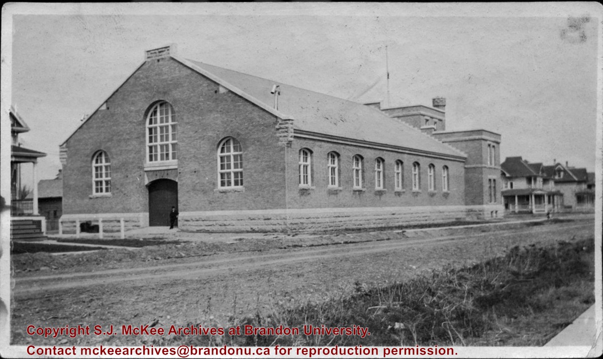
The Brandon Armoury was built in 1907. The extension on the southside was built in 1937.
Custodial History
The photograph was donated to the Archives by Cy Kenny in 2005.
Scope and Content
Photograph is looking northwest from the east side of 11th Street. It shows the back and east side of the Brandon Armoury, which is located on the at 1116 Victoria Avenue.
Name Access
Brandon Armoury
Victoria Avenue
11th Street
Subject Access
public buildings
armouries
Storage Location
BAPC photograph drawer
Images
Show Less

Brandon College campus

http://archives.brandonu.ca/en/permalink/descriptions727
Part Of
Aerial views and campus photographs
Description Level
Item
GMD
graphic
Date Range
c. 1961
Part Of
Aerial views and campus photographs
Description Level
Item
Series Number
2.1
Item Number
2.1.145
GMD
graphic
Date Range
c. 1961
Physical Description
3.5" x 5" (colour)
Material Details
Kodak paper
Scope and Content
Photograph is looking northwest probably from the northwest corner of 18th Street and Louise Avenue. The photographer was laying down when s/he took the shot. Photograph shows the field to the south of the Citizens' Science Building, as well as the Citizens' Science Building, part of the Brandon College Building and Clark Hall, and two H-Huts. The photo was taken in summer as the field is full of dandelions.
Images
Show Less

Brandon University campus

http://archives.brandonu.ca/en/permalink/descriptions771
Part Of
Aerial views and campus photographs
Description Level
Item
GMD
graphic
Date Range
c. 1980
Part Of
Aerial views and campus photographs
Description Level
Item
Series Number
2.1
Item Number
2.1.31
GMD
graphic
Date Range
c. 1980
Physical Description
5" x 4" (b/w)
Scope and Content
View is southwest from approximately 18th Street and Lorne Avenue. Photograph shows the Brandon University campus in winter, including: the Brandon University sign, the John R. Brodie Science Centre, the Citizens' Science Building and McMaster Hall.
Images
Show Less

Brandon University campus

http://archives.brandonu.ca/en/permalink/descriptions779
Part Of
Aerial views and campus photographs
Description Level
Item
GMD
graphic
Date Range
c. late 1970s
Part Of
Aerial views and campus photographs
Description Level
Item
Series Number
2.1
Item Number
2.1.46
GMD
graphic
Date Range
c. late 1970s
Physical Description
7" x 5" (colour)
Scope and Content
View is southwest from the north side of Princess Avenue. Photograph shows the original Music Building, the north driveway entrance and parts of Clark Hall and the Brandon College building.
Images
Show Less

Brandon University campus

http://archives.brandonu.ca/en/permalink/descriptions788
Part Of
Aerial views and campus photographs
Description Level
Item
GMD
graphic
Date Range
c. 1975
Part Of
Aerial views and campus photographs
Description Level
Item
Series Number
2.1
Item Number
2.1.47
GMD
graphic
Date Range
c. 1975
Physical Description
5" x 5" (b/w)
Scope and Content
View is southwest from the sidewalk on the west side of 18th Street. Photograph shows the Brandon University sign, the front lawn, the Citizens' Science Building, McMaster Hall and the John R. Brodie Science Centre.
Images
Show Less

Brandon University campus

http://archives.brandonu.ca/en/permalink/descriptions804
Part Of
Aerial views and campus photographs
Description Level
Item
GMD
graphic
Date Range
1966
Part Of
Aerial views and campus photographs
Description Level
Item
Series Number
2.1
Item Number
2.1.48
GMD
graphic
Date Range
1966
Physical Description
10" x 8" (b/w)
Scope and Content
View is south from the north side of Princess Avenue. Photograph shows the walkway leading south across campus, the original Music Building, the A.E. McKenzie Building, the J.R.C. Evans Lecture Theatre, Flora Cowan Hall and Darrach Hall.
Images
Show Less

Brandon University campus

http://archives.brandonu.ca/en/permalink/descriptions805
Part Of
Aerial views and campus photographs
Description Level
Item
GMD
graphic
Date Range
1966
Part Of
Aerial views and campus photographs
Description Level
Item
Series Number
2.1
Item Number
2.1.49
GMD
graphic
Date Range
1966
Physical Description
10" x 8" (b/w)
Scope and Content
View is southwest from Princess Avenue. Photograph shows the original Music Building, the A.E. McKenzie Building, the J.R.C. Evans Lecture Theatre and Darrach Hall. Also visible are the field where the Western Manitoba Centennial Auditorium now stands, as well as a number of houses on 20th Street.
Images
Show Less

Brandon College campus

http://archives.brandonu.ca/en/permalink/descriptions819
Part Of
Aerial views and campus photographs
Description Level
Item
GMD
graphic
Date Range
c. 1960s
Part Of
Aerial views and campus photographs
Description Level
Item
Series Number
2.1
Item Number
2.1.51
GMD
graphic
Date Range
c. 1960s
Physical Description
10" x 8" (b/w)
Scope and Content
View is southwest. Photograph shows Clark Hall, the Brandon College Building, the Citizens' Science Building and the driveway running in front of the buildings. Portions of the front lawn and the Kinsmen Staduim are also visible.
Images
Show Less

Brandon University campus

http://archives.brandonu.ca/en/permalink/descriptions836
Part Of
Aerial views and campus photographs
Description Level
Item
GMD
graphic
Date Range
1977
Part Of
Aerial views and campus photographs
Description Level
Item
Series Number
2.1
Item Number
2.1.52
GMD
graphic
Date Range
1977
Physical Description
10" x 8" (b/w)
Scope and Content
View is northeast fron the west side of the Dining Hall. Photograph shows portions of the J.R.C. Evans Lecture Theatre and the A.E. McKenzie Building, as well as an H-Hut, Clark Hall, the Brandon College Building and the quadrangle.
Images
Show Less

Brandon University driveway

http://archives.brandonu.ca/en/permalink/descriptions841
Part Of
Aerial views and campus photographs
Description Level
Item
GMD
graphic
Date Range
c. 1980s
Part Of
Aerial views and campus photographs
Description Level
Item
Series Number
2.1
Item Number
2.1.35
GMD
graphic
Date Range
c. 1980s
Physical Description
3.5" x 5" (b/w)
Scope and Content
View is north from approximately the Citizens' Science Building. Photograph shows the driveway running in front of the Brandon College Building and Clark Hall, a number of cars and students along the driveway and the Education Building in the background.
Images
Show Less

Brandon University campus

http://archives.brandonu.ca/en/permalink/descriptions850
Part Of
Aerial views and campus photographs
Description Level
Item
GMD
graphic
Date Range
May 1978
Part Of
Aerial views and campus photographs
Description Level
Item
Series Number
2.1
Item Number
2.1.36
GMD
graphic
Date Range
May 1978
Physical Description
5" x 3.5" (colour)
Scope and Content
View is northwest from the front lawn. Clark Hall and the Education Building are visible between the trees.
Images
Show Less

Brandon University campus

http://archives.brandonu.ca/en/permalink/descriptions866
Part Of
Aerial views and campus photographs
Description Level
Item
GMD
graphic
Date Range
October 1981
Part Of
Aerial views and campus photographs
Description Level
Item
Series Number
2.1
Item Number
2.1.37
GMD
graphic
Date Range
October 1981
Physical Description
3.5" x 5" (colour)
Scope and Content
View is south from the lawn in front of the Education Building and shows a student exiting the building. The driveway and John R. Brodie Science Centre are visible in the background.
Images
Show Less

Brandon College campus

http://archives.brandonu.ca/en/permalink/descriptions916
Part Of
Aerial views and campus photographs
Description Level
Item
GMD
graphic
Date Range
c. 1966
Part Of
Aerial views and campus photographs
Creator
Miles Photos
Description Level
Item
Series Number
2.1
Item Number
2.1.53
GMD
graphic
Date Range
c. 1966
Physical Description
10" x 8" (b/w)
Scope and Content
View is northwest from the front lawn. Photograph shows the Citizens' Science Building, an H-Hut, the Brandon College Building, Clark Hall and the original Music Building.
Images
Show Less

Brandon University campus

http://archives.brandonu.ca/en/permalink/descriptions917
Part Of
Aerial views and campus photographs
Description Level
Item
GMD
graphic
Date Range
c. 1967
Part Of
Aerial views and campus photographs
Description Level
Item
Series Number
2.1
Item Number
2.1.54
GMD
graphic
Date Range
c. 1967
Physical Description
10" x 8" (b/w)
Physical Condition
Photograph has a couple of cracks, due to bending.
Scope and Content
View is northwest from the front lawn. Photograph shows the Brandon College Building, Clark Hall, the parking lot in front of those two buildings and the Education building.
Images
Show Less

20 records – page 1 of 1.