Skip header and navigation

Revise Search

20 records – page 5 of 1.

McGuinness Medicine Hat residence - aerial

http://archives.brandonu.ca/en/permalink/descriptions14115
Part Of
Fred McGuinness collection
Description Level
Item
GMD
graphic
Date Range
[1960-1965]
Accession Number
1-2015
Part Of
Fred McGuinness collection
Description Level
Item
Series Number
McG 9
Item Number
1-2015.184
Accession Number
1-2015
GMD
graphic
Date Range
[1960-1965]
Physical Description
10" x 8" (b/w)
Scope and Content
Photograph shows the construction of the McGuinness home in a new housing development in Medicine Hat, 492 6th Street Northeast. Aerial view shows that neighbouring blocks have yet to be constructed.
Name Access
Fred McGuinness
Frederick George McGuinness
Medicine Hat
Subject Access
residences
street scenes
residential streets
winter
aerial views
aerial photography
Storage Location
RG 5 photograph storage drawer 2 (hanging photos)
Arrangement
BR #3 Family photos
Images
Show Less

McGuinness Medicine Hat residence - winter aerial

http://archives.brandonu.ca/en/permalink/descriptions14116
Part Of
Fred McGuinness collection
Description Level
Item
GMD
graphic
Date Range
[1960-1965]
Accession Number
1-2015
Part Of
Fred McGuinness collection
Description Level
Item
Series Number
McG 9
Item Number
1-2015.185
Accession Number
1-2015
GMD
graphic
Date Range
[1960-1965]
Physical Description
10" x 8" (b/w)
Scope and Content
Photograph shows the McGuinness home in a new housing development in Medicine Hat, 492 6th Street Northeast. Aerial view shows that neighbouring blocks have yet to be constructed and the backyard to the McGuinness home is completed.
Name Access
Fred McGuinness
Frederick George McGuinness
Medicine Hat
Subject Access
residences
street scenes
residential streets
winter
aerial views
aerial photography
Storage Location
RG 5 photograph storage drawer 2 (hanging photos)
Arrangement
BR #3 Family photos
Images
Show Less

Medicine Hat Exhibition and Stampede - Parade Day 4

http://archives.brandonu.ca/en/permalink/descriptions14145
Part Of
Fred McGuinness collection
Description Level
Item
GMD
graphic
Date Range
1962
Accession Number
1-2015
Part Of
Fred McGuinness collection
Creator
Photographer: Howard Heid, Medicine Hat News
Description Level
Item
Series Number
McG 9
Item Number
1-2015.214
Accession Number
1-2015
GMD
graphic
Date Range
1962
Physical Description
10" x 8" (b/w)
History / Biographical
The Medicine Hat Exhibition and Stampede Parade Day was held on Thursday, July 19, 1962, at 9:30 a.m. The local newspaper reported that approximately 24,000 people were in attendance to see parade marshall Rod Ashburner leading 175 entries consisting of 90 floats, 75 horses, and 10 bands. There were 19 parade categories eligible for $12,000 in prize money and included: junior and senior cowboys and cowgirls; fancy and Shetland ponies; sulky class open; comic, commercial, industrial and organizational floats; decorated cars; special ranch class; 4-H Clubs; and a non-competitive class. The parade route started at Second St. and Allowance Ave., from Second St. to Ash Ave., north on Ash to First St. SE., from First St. S.E. to Fourth Ave., south to Second St. to South Railway St., south on South Railway St. to Third St., with a finish at McLeod Trail. A route map was published in the Medicine Hat News the day before the parade. Aerial photographs of the parade were taken by Medicine Hat News photographer Howard Heid (1930-2005) from the private helicopter of John Bourn. Bourn was a pilot from Woodville, Wisconsin, who chartered his four-seater helicopter for sight-seers at exhibitions and stampedes across the county. (Sources: Pat Currie, "Let 'Er Go!," Medicine Hat News, 19 July 1962,1; Harald Gunderson, "'Eye in the Sky' Best Parade View," Medicine Hat News, 19 July 1962,1; "Parade Starts at 9:30 Sharp," 18 July 1962)
Scope and Content
Photograph shows an aerial view of the Medicine Hat Exhibition and Stampede Parade route with a focus on the First Street SE. A number of gas stations and garages are visible along this route and include Texaco, Shell, Ford, and B/A. The Fraternal Order of Eagles lodge is also visible.
Notes
This photograph appeared on the front page of The Medicine Hat News (19 July 1962).
Name Access
Medicine Hat
South Saskatchewan River
Subject Access
parades
floats
aerial photography
aerial views
street scenes
fraternal organizations
garages
Repro Restriction
Subject to Canadian Copyright Law
Storage Location
RG 5 photograph storage drawer 2 (hanging photos)
Arrangement
BR #3 Family photos
Images
Show Less

Aerial view: Brandon College campus

http://archives.brandonu.ca/en/permalink/descriptions8272
Part Of
Aerial views and campus photographs
Description Level
Item
GMD
graphic
Date Range
c. 1964
Part Of
Aerial views and campus photographs
Description Level
Item
Series Number
2.1
Item Number
2.1.1
GMD
graphic
Date Range
c. 1964
Physical Description
4" x 5" (b/w)
Scope and Content
Photograph is looking northwest from approximately the southeast corner of 18th Street and Louise Avenue.
Name Access
Flora Cowan Residence
Subject Access
Aerial views Brandon College
Images
Show Less

Aerial views and campus photographs

http://archives.brandonu.ca/en/permalink/descriptions6
Part Of
BUPC 2 Campus buildings
Description Level
Sub-series
GMD
graphic
Date Range
c.1920s; c.1950s - c.2000
Part Of
BUPC 2 Campus buildings
Description Level
Sub-series
Series Number
2.1
GMD
graphic
Date Range
c.1920s; c.1950s - c.2000
Physical Description
146 photographs
History / Biographical
Aerial photographs of the campus were generally commissioned by the College/University to record important milestones, such as centennials, changes in status, and building projects. The general campus photographs were placed in this sub-series because the composition of the images made it difficult to place them with individual buildings.
Scope and Content
Sub-series consists of photographs of the Brandon College and Brandon University campus.
Name Access
Flora Cowan Residence
Subject Access
Aerial views Brandon College
Show Less

Medicine Hat Exhibition and Stampede - Parade Day 6

http://archives.brandonu.ca/en/permalink/descriptions14147
Part Of
Fred McGuinness collection
Description Level
Item
GMD
graphic
Date Range
1962
Accession Number
1-2015
Part Of
Fred McGuinness collection
Creator
Photographer: Howard Heid, Medicine Hat News
Description Level
Item
Series Number
McG 9
Item Number
1-2015.216
Accession Number
1-2015
GMD
graphic
Date Range
1962
Physical Description
10" x 8" (b/w)
History / Biographical
The Medicine Hat Exhibition and Stampede Parade Day was held on Thursday, July 19, 1962, at 9:30 a.m. The local newspaper reported that approximately 24,000 people were in attendance to see parade marshall Rod Ashburner leading 175 entries consisting of 90 floats, 75 horses, and 10 bands. There were 19 parade categories eligible for $12,000 in prize money and included: junior and senior cowboys and cowgirls; fancy and Shetland ponies; sulky class open; comic, commercial, industrial and organizational floats; decorated cars; special ranch class; 4-H Clubs; and a non-competitive class. The parade route started at Second St. and Allowance Ave., from Second St. to Ash Ave., north on Ash to First St. SE., from First St. S.E. to Fourth Ave., south to Second St. to South Railway St., south on South Railway St. to Third St., with a finish at McLeod Trail. A route map was published in the Medicine Hat News the day before the parade. Aerial photographs of the parade were taken by Medicine Hat News photographer Howard Heid (1930-2005) from the private helicopter of John Bourn. Bourn was a pilot from Woodville, Wisconsin, who chartered his four-seater helicopter for sight-seers at exhibitions and stampedes across the county. (Sources: Pat Currie, "Let 'Er Go!," Medicine Hat News, 19 July 1962,1; Harald Gunderson, "'Eye in the Sky' Best Parade View," Medicine Hat News, 19 July 1962,1; "Parade Starts at 9:30 Sharp," 18 July 1962)
Scope and Content
Photograph shows an aerial view of the Medicine Hat Exhibition and Stampede Parade route with a focus on the First Street SE and and the South Railway Street merge. A number of gas stations and garages are visible along this route and include Texaco, Shell, Ford, and B/A. The Fraternal Order of Eagles lodge is also visible.
Notes
This photograph shows the neighbourhood before rezoning and commercial development.
Name Access
Medicine Hat
South Saskatchewan River
Subject Access
parades
floats
aerial photography
aerial views
street scenes
gardens
fraternal organizations
garages
Repro Restriction
Subject to Canadian Copyright Law
Storage Location
RG 5 photograph storage drawer 2 (hanging photos)
Arrangement
BR #3 Family photos
Images
Show Less
Part Of
Alf Fowler collection
Description Level
Item
GMD
graphic
Date Range
ca. 1911
Accession Number
6-1999
Part Of
Alf Fowler collection
Creator
Davidson & Gowen
Description Level
Item
Item Number
6-1999.46
Accession Number
6-1999
GMD
graphic
Date Range
ca. 1911
Physical Description
9" x 7" (b/w)
History / Biographical
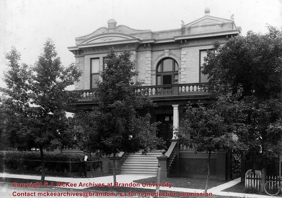
The Brandon Club, designed in 1904 by local architect and builder W.R. Marshall, was Brandon's oldest chartered club. It was located at 158 11th Street. In the early years as an exclusive institution, the club boased such notable members as Sir Clifford Sifton, Senator J.N. Kirchoffer, and Sir R.P. Roblin. The Brandon Club closed its doors c. 2005. At present (June 2007), it is the future home of Lennon Trilogy, professional land surveyors.
Custodial History
See fonds level description of the Alf Fowler collection for custodial history.
Scope and Content
Photo shows the exterior of the Brandon Club. Photograph is looking west.
Notes
History/Bio information taken from the Assiniboine Historical Society's Brandon: An Architectural Walking Tour pamphlet (1982).
Storage Range
RG 5 Western Manitoba Manuscript collection - photograph storage drawer
Images
Show Less
Part Of
RG 11 Lawrence Stuckey fonds
Description Level
Item
GMD
graphic
Date Range
[19-?]
Accession Number
1-2002
Part Of
RG 11 Lawrence Stuckey fonds
Description Level
Item
Series Number
3.1
Item Number
1-2002.3.1AH3
Accession Number
1-2002
GMD
graphic
Date Range
[19-?]
Physical Description
3 1/2" x 5"
Material Details
Negative
Custodial History
For custodial history see the collection level description of the Lawrence Stuckey collection.
Scope and Content
A Brandon hunting club?
Name Access
Hunting Club
Subject Access
organizations
social clubs
sports
hunting
Brandon sports people & activities
Repro Restriction
The McKee Archives is the copyright holder for the Stuckey materials.
Storage Location
Lawrence Stuckey collection
Images
Show Less
Part Of
Brandon University Photograph collection
Description Level
Item
GMD
graphic
Date Range
May 12, 1992
Part Of
Brandon University Photograph collection
Description Level
Item
Series Number
2.1
Item Number
BUPC 2.1.62
GMD
graphic
Date Range
May 12, 1992
Physical Description
5.75" x 3.75" (colour)
Scope and Content
Photograph shows a backhoe digging a sewer hole near the sidewalk between the Brandon College Building and the Citizens' Science Building. The Knowles-Douglas Students' Union Centre, John R. Brodie Science Centre and a portion of the driveway are visible in the background.
Subject Access
campus photographs
campus buildings
campus construction
Images
Show Less

Brandon University campus

http://archives.brandonu.ca/en/permalink/descriptions7997
Part Of
Brandon University Photograph collection
Description Level
Item
GMD
graphic
Date Range
c. 1996
Part Of
Brandon University Photograph collection
Creator
Photographer: Sandy Black
Description Level
Item
Series Number
2.1
Item Number
BUPC 2.1.63
GMD
graphic
Date Range
c. 1996
Physical Description
6" x 4" (colour)
Scope and Content
View is northwest from the roof of the John R. Brodie Science Centre. Photograph shows the roof of the Knowles Douglas Students' Union Centre, the Citizens' Science Building, and the Brandon College Building and Clark Hall during renovation.
Subject Access
campus photographs
campus buildings
campus construction
Images
Show Less

Brandon University campus construction

http://archives.brandonu.ca/en/permalink/descriptions8000
Part Of
Brandon University Photograph collection
Description Level
Item
GMD
graphic
Date Range
c. 1996
Part Of
Brandon University Photograph collection
Creator
Photographer: Sandy Black
Description Level
Item
Series Number
2.1
Item Number
BUPC 2.1.66
GMD
graphic
Date Range
c. 1996
Physical Description
6" x 4" (colour)
Scope and Content
View is southeast from the roof of the A.E. McKenzie Building. Photograph shows the construction of the extension of Clark Hall and the skywalk.
Subject Access
campus photographs
campus buildings
campus construction
Images
Show Less

Brandon University campus construction

http://archives.brandonu.ca/en/permalink/descriptions8001
Part Of
Brandon University Photograph collection
Description Level
Item
GMD
graphic
Date Range
c. 1996
Part Of
Brandon University Photograph collection
Creator
Photographer: Sandy Black
Description Level
Item
Series Number
2.1
Item Number
BUPC 2.1.67
GMD
graphic
Date Range
c. 1996
Physical Description
6" x 4" (colour)
Scope and Content
View is north probably from the roof of McMaster Hall. Photograph shows the construction of the extension of Clark Hall and the skywalk.
Subject Access
campus photographs
campus buildings
campus construction
Images
Show Less

Brandon University campus construction

http://archives.brandonu.ca/en/permalink/descriptions8002
Part Of
Brandon University Photograph collection
Description Level
Item
GMD
graphic
Date Range
c. 1996
Part Of
Brandon University Photograph collection
Creator
Photographer: Sandy Black
Description Level
Item
Series Number
2.1
Item Number
BUPC 2.1.68
GMD
graphic
Date Range
c. 1996
Physical Description
6" x 4" (colour)
Scope and Content
View is north probably from the roof of McMaster Hall. Photograph shows the construction of the new roof on Clark Hall and the Brandon College Building.
Subject Access
campus photographs
campus buildings
campus construction
Images
Show Less

Brandon University campus construction

http://archives.brandonu.ca/en/permalink/descriptions8003
Part Of
Brandon University Photograph collection
Description Level
Item
GMD
graphic
Date Range
c. 1996
Part Of
Brandon University Photograph collection
Description Level
Item
Series Number
2.1
Item Number
2.1.69
GMD
graphic
Date Range
c. 1996
Physical Description
6" x 4" (colour)
Scope and Content
View is southwest from Clark Hall. Photograph shows the construction of the extension of Clark Hall.
Subject Access
campus photographs
campus buildings
campus construction
Images
Show Less

Brandon University campus construction

http://archives.brandonu.ca/en/permalink/descriptions8004
Part Of
Brandon University Photograph collection
Description Level
Item
GMD
graphic
Date Range
c. 1996
Part Of
Brandon University Photograph collection
Creator
Photographer: Sandy Black
Description Level
Item
Series Number
2.1
Item Number
BUPC 2.1.70
GMD
graphic
Date Range
c. 1996
Physical Description
6" x 4" (colour)
Scope and Content
View is north probably from the roof of McMaster Hall. Photograph shows the construction of the extension to Clark Hall and the skywalk. Also visible are the A.E. McKenzie Building, the Brandon College Building, the Education Building, the original Music Building and the Western Manitoba Centennial Auditorium, as well as the walkway that runs north between the buildings and the courtyard.
Subject Access
campus photographs
campus buildings
campus construction
Show Less

Brandon University campus construction

http://archives.brandonu.ca/en/permalink/descriptions8010
Part Of
Brandon University Photograph collection
Description Level
Item
GMD
graphic
Date Range
c. 1996
Part Of
Brandon University Photograph collection
Description Level
Item
Series Number
2.1
Item Number
BUPC 2.1.76
GMD
graphic
Date Range
c. 1996
Physical Description
4" x 6" (colour)
Scope and Content
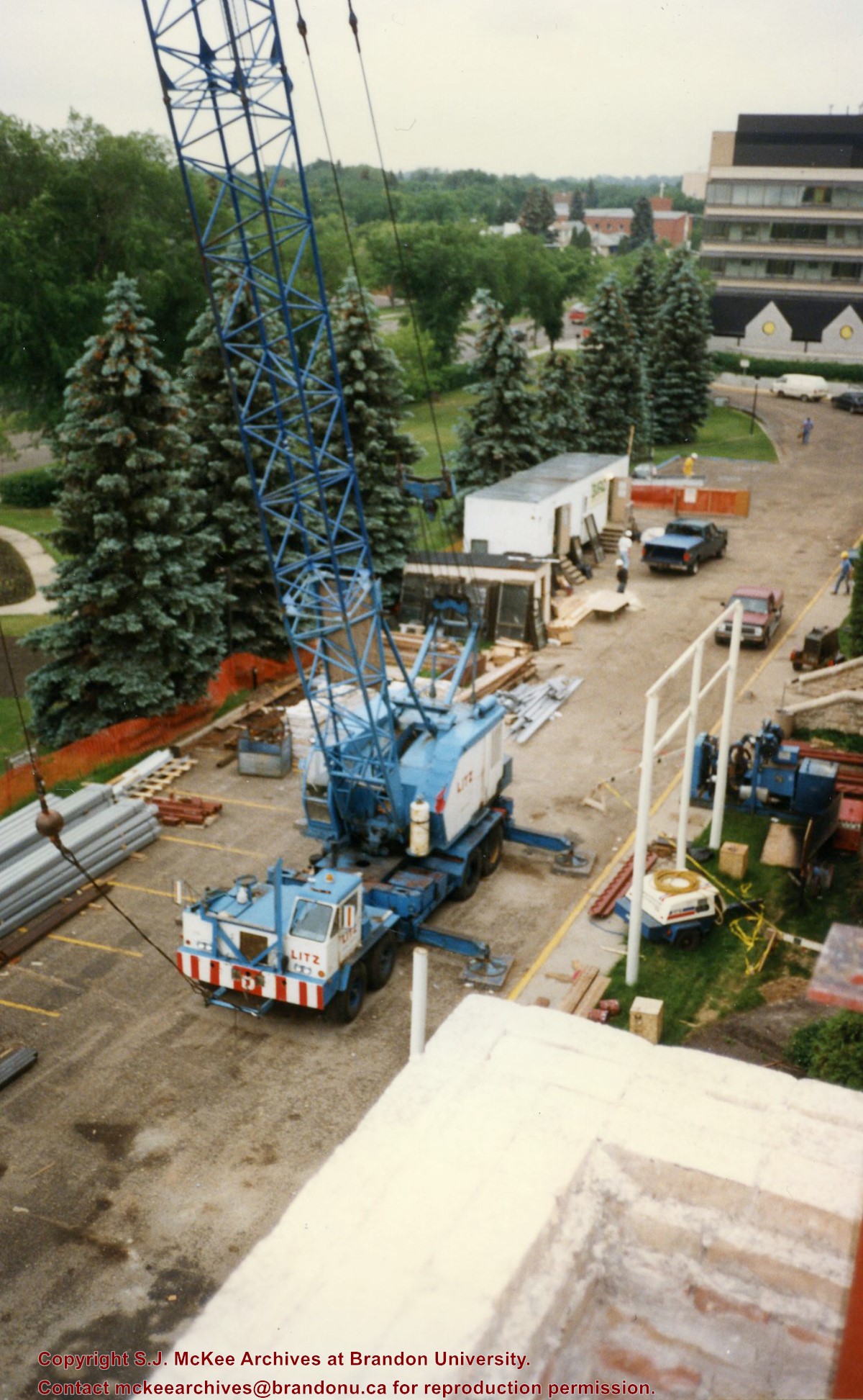
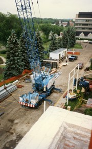
View is southeast from Clark Hall. Photograph shows a large crane, building materials and machines and the construction trailer (Bird Construction) on the driveway during the restoration of Clark Hall and the Brandon College Building. Portions of the front lawn, the John R. Brodie Science Centre and the Knowles Douglas Students' Union Centre are also visible. In the distance is Knox United Church.
Subject Access
campus photographs
campus buildings
campus construction
Images
Show Less

Brandon University campus construction

http://archives.brandonu.ca/en/permalink/descriptions8016
Part Of
Brandon University Photograph collection
Description Level
Item
GMD
graphic
Date Range
c. 1996
Part Of
Brandon University Photograph collection
Creator
Photographer: Sandy Black
Description Level
Item
Series Number
2.1
Item Number
BUPC 2.1.82
GMD
graphic
Date Range
c. 1996
Physical Description
4" x 6" (colour)
Scope and Content
View is northeast from the Brandon College Building. Photograph shows the inside of the Brandon College Building after it had been gutted and then partially rebuilt. The exterior fascade of the west side of the building can be clearly seen in this photograph. A number of houses on the east side of 200 block of 18th Street are also visible, as is the stone fence on Princess Avenue and the flag pole on the front lawn.
Subject Access
campus photographs
campus construction
Brandon streets
Images
Show Less

Brandon University campus construction

http://archives.brandonu.ca/en/permalink/descriptions8019
Part Of
Brandon University Photograph collection
Description Level
Item
GMD
graphic
Date Range
c. 1996
Part Of
Brandon University Photograph collection
Description Level
Item
Series Number
2.1
Item Number
BUPC 2.1.85
GMD
graphic
Date Range
c. 1996
Physical Description
4" x 6" (colour)
Scope and Content
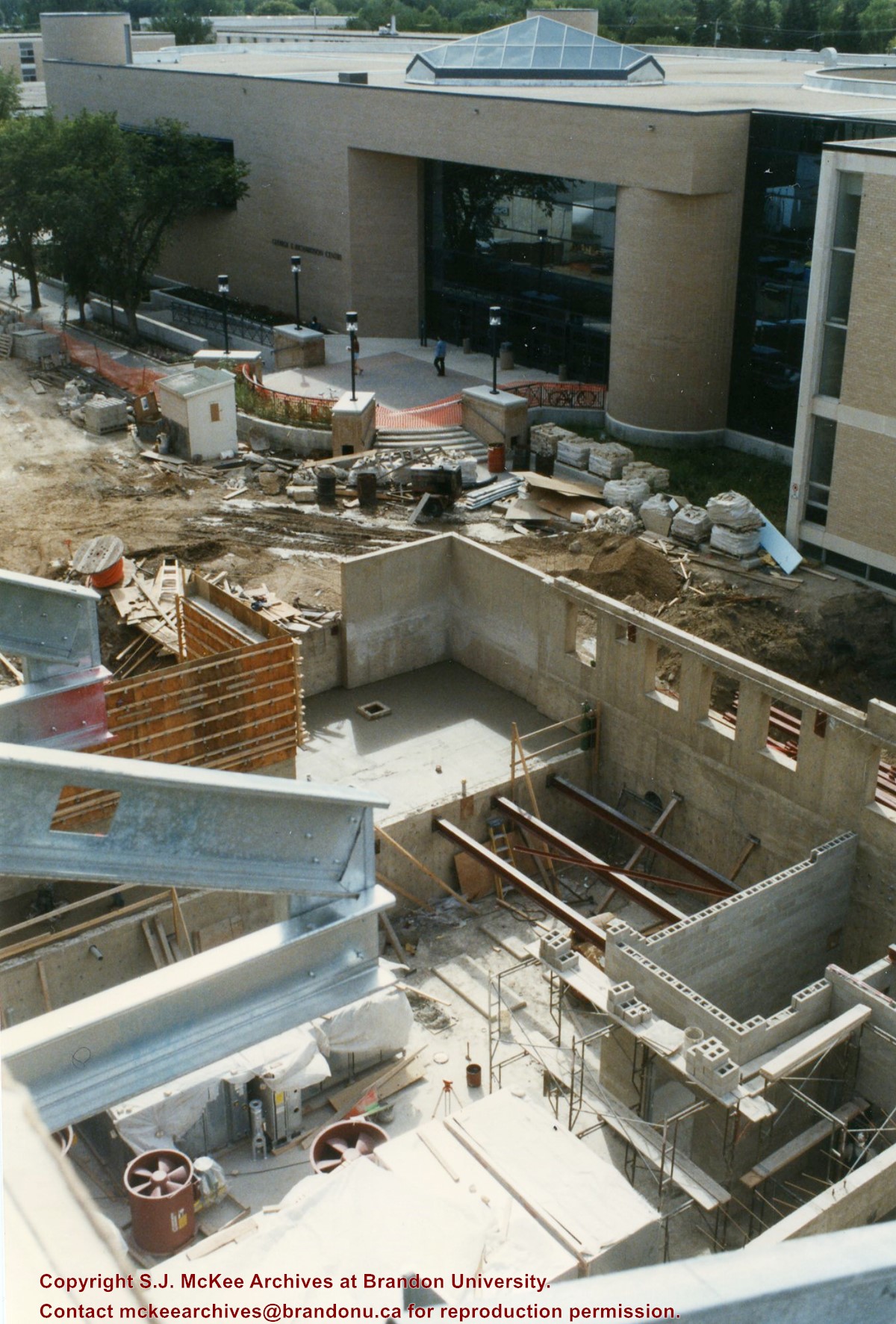
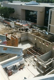
View is southwest from the roof of Clark Hall. Photograph shows the construction of the foundation and exterior walls of the Clark Hall extension. George T. Richardson Centre and construciton materials in the background.
Subject Access
campus photographs
campus buildings
campus construction
Images
Show Less

Brandon University campus construction

http://archives.brandonu.ca/en/permalink/descriptions8022
Part Of
Brandon University Photograph collection
Description Level
Item
GMD
graphic
Date Range
c. 1996
Part Of
Brandon University Photograph collection
Creator
Photographer: Sandy Black
Description Level
Item
Series Number
2.1
Item Number
BUPC 2.1.88
GMD
graphic
Date Range
c. 1996
Physical Description
4" x 6" (colour)
Scope and Content
View is north northwest from the roof of the John R. Brodie Science Centre. Photograph shows the Knowles Douglas Students' Union Building, and the Citizens' Science Building, the Brandon College Building and Clark Hall under restoration, as well as parts of the driveway and front lawn, including the flag pole.
Subject Access
campus photographs
campus buildings
campus construction
Images
Show Less
Part Of
CKX fonds
Description Level
Item
GMD
graphic
Date Range
1967
Accession Number
11-2010
Part Of
CKX fonds
Creator
CKX
Description Level
Item
Series Number
U
Item Number
11-2010.U7l
Accession Number
11-2010
GMD
graphic
Date Range
1967
Physical Description
1.5" x 1.5" (b/w)
Material Details
Negative
Custodial History
See fonds level of the CKX records for custodial history.
Scope and Content
Image of a Ukrainian Orthodox priest putting a photo behind a plaque.
Name Access
CKX
Subject Access
persons
religious persons
building exteriors
photographs
Storage Location
CKX fonds - 2010 accessions
Images
Show Less

20 records – page 5 of 1.