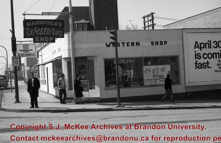
Mansfield's Western Shop was located on the corner of 6th Street and Princess Avenue at 603 Princess Avenue. The business appears to have been opened in 1966 by Ed and Jessie Mansfield. The shop was originally owened by Norman D. Moore and was called Moore's Western Shop. According to the Henderson's Brandon City Directory Mansfield's was relocated several times during its ownership. In 1967 Mansfields was reloacted to 737 11th Street, by 1973 had relocated again to 731 Princess Avenue and remained there until at least 1984. Mansfield's Western Shop had moved to it's final location at 1130 18th Street by 1988. Once Ed and Jessie retired the shop was taken over by their sons Les and Lyle Mansfield. Les and Lyle closed the store when they retired in 2015. Presently (2020) the H&Co Acadamy building stands where the original Mansfields Western Shop stood on 6th Street.
For images on the Central Fire Station see the McGuiness Collection (20-2009) and the Lawrence Stuckey Collection (1-2002)
Seiberling The Tire Exchange was located at 603 Princess Avenue next to Mansfield's Western Shop. The business appears to have been opened in 1963. The shop was originally owned by Norman D. Moore who bought the shop in 1945 and named the business Moores Tire Service. By 1972 Seiberling Tire Exchange had closed and Lyon's Tire City had opened and would remain there until 1976.
Custodial History
See Fonds level description for custodial history
Scope and Content
Image of the exterior of Mansfield's Western Shop looking on the corner of 6th Street and Princess Avenue.The image is looking west down Princess Avenue. Seiberling The Tire Exchange and the Central Fire Station are both visible west of Mansfield's Western Shop.
Notes
Hisotry/Bio information taken from Henderson's Directories. Description by Jillian Combs. Photo likely taken before April 30th based on the sign on the side of the building.
Photograph shows the Brandon Wheat Market along Pacific Avenue on November 30, 1885. Farmers can be seen driving wagon teams loaded with bags of grain in line on Pacific Avenue from 10 Street to at least 7th Street. On the north side of Pacific Avenue the CPR Land Office and grain elevators are pictured. On the south side of Pacific Avenue, the general merchant/hardware store Bower, Blackburn, Mundell & Porter is situated on the corner of Pacific Avenue and 10th Street. A 10th Street sign is affixed to the merchants' store. On the east side of the general store, Edie House, the Grand View Hotel, and a Farmers' boarding and lodging house can be seen. Most of the buildings appear to be woodframed except for the Grand View, which is constructed of brick. Sidewalks appear to be in place on the south side of Pacific and snow dusts the streets. A baby swathed in winter clothing sits in a pram/baby carriage in front of the general store.
Notes
Writing on the front of the photograph reads: Novemeber 30th, 1885, Brandon Wheat Market
Mark 7 Hobbycrafts and Religious Supplies was located in the Security Building at 21 on 10th Street. The business appears to have opened on October 31 1966 and was owned by Lorne Baldrow. The previous owner of the store was Agusuta E. Wing and had called the store the Christian Book and Music Center. The store appears to have closed around 1969 when Lorne and his wife Edna moved to Calgary.
Custodial History
See fonds level description for custordial history.
Scope and Content
Image of the exterior of Mark 7 Hobbycrafts and Religious Supplies. Visible to the right is the office of Gerald Dressler, Optomistrist. To the left is a tenant sign for the Security Building. Tenants in 1968 included: the John Howard Society, Brandon Emergency Measures Organization, Viscount Optical, Kent's Accordion College, and Loch Lomond Knitwear Lts.
Notes
History/bio information taken from Henderson's Directories. Description by Christy Henry.
Photographs have been glued to a backing board that has warped over time
Scope and Content
Photograph shows street view of north side of Rosser Avenue, primarily the 700 block, along which sewer pipe is being laid. Visible buildings and businesses include: The Fleming Block with Lowes Brothers Clothing and Manitoba Farmers Hedge and Wire Fence Company, the Beaubier Block and its Empire Hotel, A.M. Percival (a grocer), the Brandon Hardware Company (600 block), and the Arlington Hotel (500 block) are visible along the north side of the avenue. The Bank of Hamilton Building is on the southeast corner of 8th Street and Rosser Avenue.
Notes
Writing on the front of the photograph matting reads: 290. Page appears to be from a photo album.
See fonds level of the CKX records for custodial history.
Scope and Content
Image of the southside of the 1100 block of Rosser Avenue in winter. Visible are O.L. Harwood Ltd., the Key Kafe and Northern Auto Parts. The Perth's building, located in the 1200 block, can be seen on the righthand side in the background. A number of vehicles, a pedestrian and a man shovelling snow are also visible.
Postcard shows the 100 block of 10th Street facing north. The CPR train station can be seen at the end of 10th Street. The sign for the Rex Cafe is visible on the west side of 10th Street. On the east side of 10th Street, billboards for Campbell & Campbell furniture are visible as well as signs for Pianos and the Orpheum Theatre. Motorists and cyclists share the road. Street car tracks run the length of 10th Street.
Notes
Back of postcard reads: Morning reflection of Brandon's skyline on the Assiniboine River, photo by Sandy Black, printed in Brandno, Manitoba, Canada by Leech Printing Ltd.
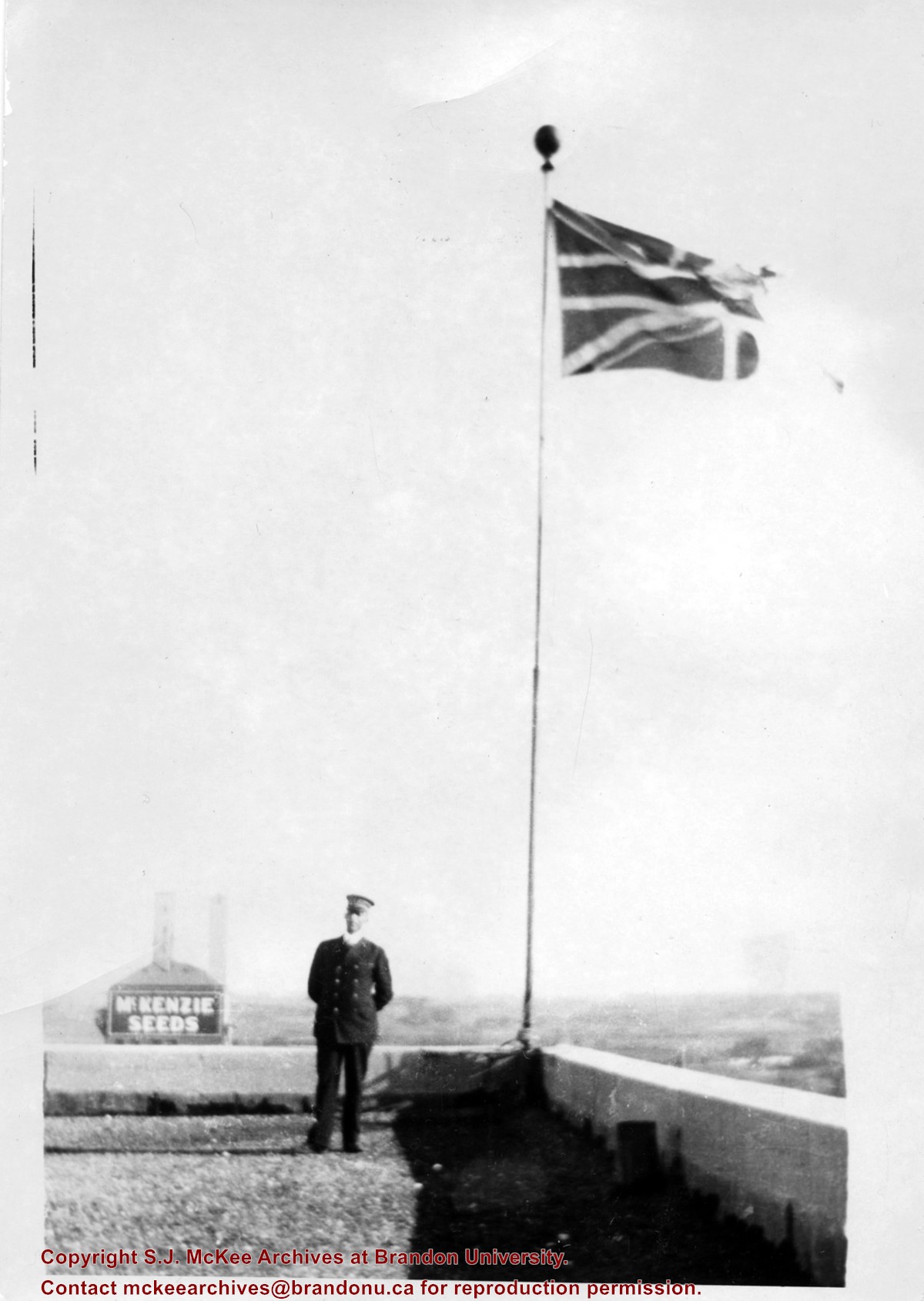
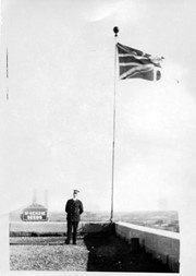
Photograph shows a view from the rooftop of the Prince Edward Hotel. The south side of the Brandon Hotel (most recently the Brandon Inn) and a service station along Prince Avenue can be seen.
Notes
Writing on the back of photograph reads: across the street from roof of P.E. Hotel 1927
See fonds level of the CKX records for custodial history.
Scope and Content
Image of the southside of the 1000 and 1100 block of Rosser Avenue looking east in winter. Visible in the foregraound are O.L. Harwood Ltd., and the Key Kafe. Buildings in the 1000 block include: the Imperial Bank of Canada, the original Post Office and Federal Building and the original Merchants Bank. A number of pedestrians are also visible, as are Christmas decorations on the streetlights and telephone poles.
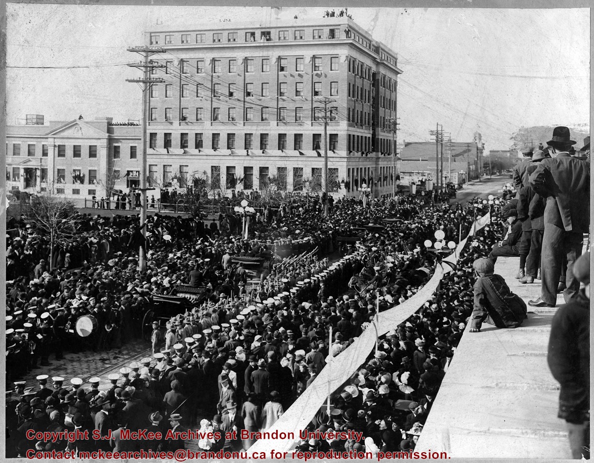
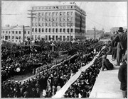
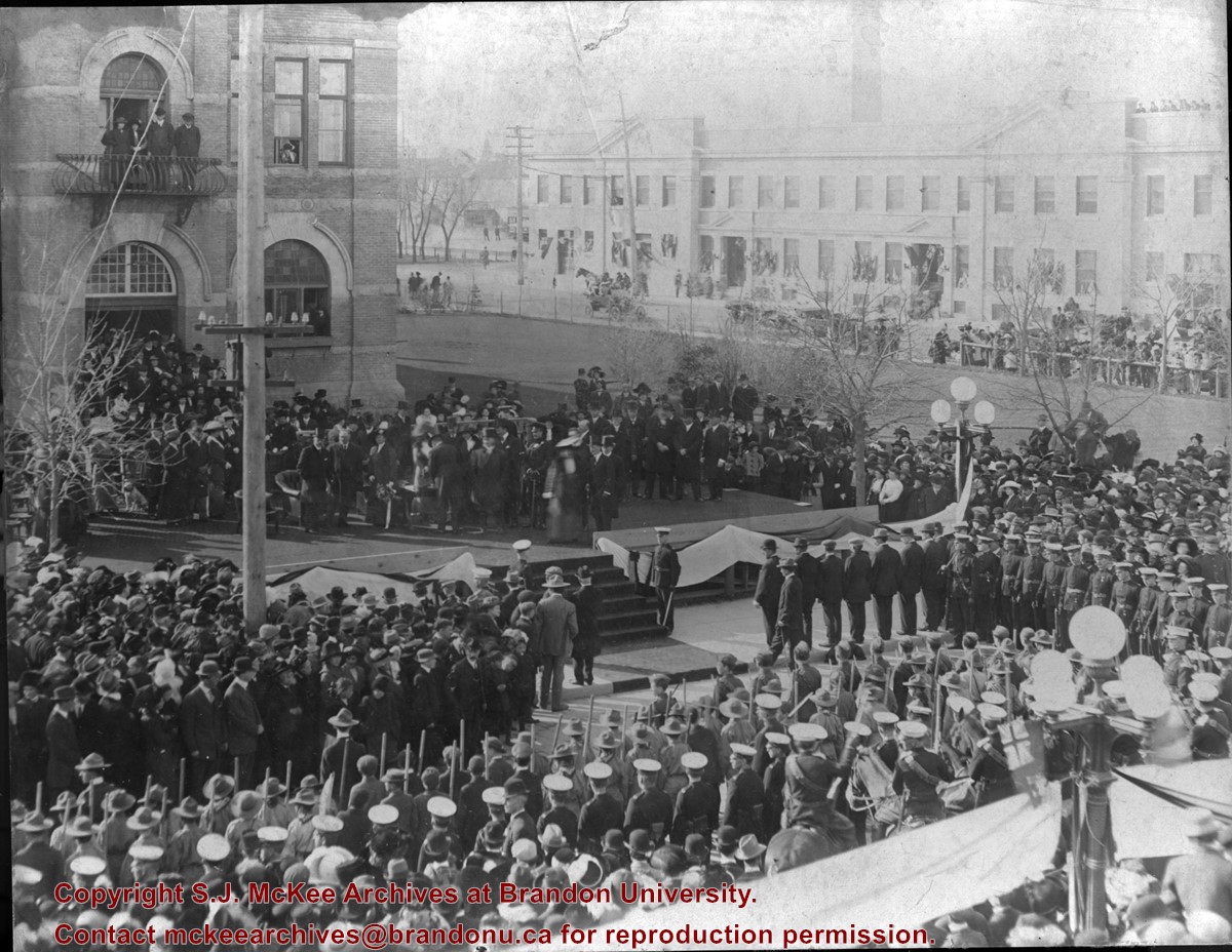
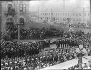
Photograph shows a public reception for the Governor General of Canada, HRH the Duke of Connaught during a visit to Brandon, MB. The reception was held on Princess Avenue at City Hall. The photograph is looking southwest from the north side of Princess Avenue. The building in the background is the recently constructed Prince Edward Hotel.
There is staining from the top left corner towards the centre of the image.
Custodial History
Jack Stothard purchased the image at a yard sale, location unknown. He donated it to the Archives in 2006.
Scope and Content
Photograph of a public reception for the Governor General of Canada, HRH the Duke of Connaught. The reception was held in fromt of the Brandon City Hall, which was located at 9th Street and Princess Avenue. The photograph is looking south southeast. A portion of the recently constructed Prince Edward Hotel is visible in the background.
Photographs have been glued to a backing board that has warped over time
Scope and Content
Photograph shows parade floats travelling on 100 block of 8th Street (Brandon). Horse-drawn floats appear to belong to the Amalgamated Society of Carpenters and Joiners, Murdock/Murdoch Brothers (furniture dealers), and F.W. Durst (cement contractor). Businesses visible in the background include the Sylvester Brothers Manufacturing Company and McDiarmid and Clarke lumber and fuel yard. Spectators in the foreground are leaning on a wooden fence likely belonging to the Old City Hall.
Notes
Writing on the front of the photograph matting reads: 315 July 1906. Two photographs (20-2009.7, 20-2009.6) are glued on the reverse side. Page appears to be from a photo album.
Photographs have been glued to a backing board that has warped over time
Custodial History
On 16 November 1906, Manitoba was hit by a severe winter storm that began that Thursday evening and extended through the weekend. The Brandon Daily Sun ("Storm Extends Over a Large Territory," 17 Nov. 1906, 1) reported that rail and telegraph services had been disrupted, country roads were impassable, and business in town was at a stand still. Following the weekend, the daily reported the blizzard was one of the greatest in recent memory. CPR trains had been caught in drifts by Carberry and an express car had caught fire and was destroyed ("Worst Storm in Many Years," Brandon Daily Sun, 19 Nov. 1906, 1).
Scope and Content
Photograph shows street view of north side of Rosser Avenue, primarily the 700 block. The Fleming Block, Beaubier Block and its Empire Hotel, A.M. Percival (a grocer), the Brandon Hardware Company (600 block), and the Arlington Hotel (500 block) are visible along the north side of the avenue. The Bank of Hamilton Building on the southeast corner of 8th Street and Rosser appears to be under construction. The streets are muddy and a horse and buggy is traveling west on Rosser Avenue.
Notes
Writing on the front of the photograph matting reads: during the great storm of November 16 1906, 341. The photograph appears to be taken from the interior of a builing on the southwest corner of 7th Street and Rosser Avenue. Page appears to be from a photo album.
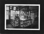
Photograph shows the interior of a store primarily selling pipes, cigars, and postcards.
Notes
Writing on the back reads: Letters on right-hand door read IMP, probably Imperial - Rosser [807] at Eigth Street. The handwriting is Fred McGuinness'. Date ascertained from Saskatoon Fair poster hanging on wall at right of photograph. Business name retrieved from Henderson's Brandon City Directory 1911. Adams Shoe Company store front visible through shop's windows.
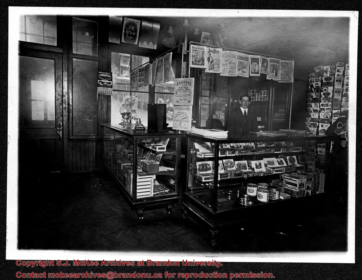
Photograph shows the interior of a store primarily selling pipes, cigars, and postcards.
Notes
Handwriting on back of phograph reads: Harry Finnegan, Brandon, Man. Date ascertained from Waterloo Manufacturing Co. calendar hanging by door at left of photograph. Interior furnishings same as photograph 20-2009.2.
Photographs have been glued to a backing board that has warped over time
Scope and Content
Photograph shows street view of north side of Rosser Avenue, primarily the 700 block. Horse and buggies are travelling on the avenue and pedestrians fill the sidewalks. Union Jacks and English flags are mounted from the windows on the Fleming and Beaubier blocks. Flag banners are drapped across Rosser Avenue. Businesses visible in the Fleming Block include: Lowes Brothers Clothing and Spring Park Nurseries. Businesses visible in the Beaubier Block include the Empire Hotel. Businesses east of the Empire Hotel are grocer A.M. Percival and the Brandon Hardware Company. An advertisement for the Northern Bank is affixed to a telephone pole on the southside of the street.
Notes
Writing on the front of the photograph matting reads: July 1 1906, 314. One photograph (20-2009.8) is glued below and another, 20-2009.6, is glued on the reverse side. Page appears to be from a photo album.
Left hand corner of mat is bent. Mock-up instructions are written in pencil at the bottom right hand corner. Portions of the photograph itself are marked with pen.
History / Biographical
The Queen's Hotel was located on the corner of Rosser Avenue and Tenth Street (Steen & Boyce, 1882. Brandon, Manitoba, Canada and Her Industries. Steen & Boyce Publishers Printers & Binders, 81.). Therefore this photo appears to display Rosser Avenue looking east. P.E. 11/06/09
Scope and Content
Photograph shows early Rosser Avenue under construction between 9th Street and 10th Street in the 1880s. Buildings that line the avenue are wood framed and there are wooden boardwalks in front of a few structures. On the north side of Rosser Avenue signs for Fortier & Bucke Commision Agents and Transit House (Hotel) can be seen. On the south side of Rosser Avenue, the Queen's Hotel and Robinson Brothers and Company groceries and dry goods store are open for business. A family appears to be standing on the stoop at the dry goods store. A boy is lounging in the entryway of the Queen's Hotel. A man is standing on a wooden plank that extends across the dirt road of Rosser Avenue between the dry goods store and the commission agents' shop.
Photographs have been glued to a backing board that has warped over time
Scope and Content
Photograph shows street view of north side of Rosser Avenue, primarily the 700 block. Horse and buggies are travelling on the avenue and pedestrians fill the sidewalks. Union Jacks and English flags are mounted from the windows on the Fleming and Beaubier blocks. Flag banners are drapped across Rosser Avenue. Businesses visible in the Fleming Block include: Lowes Brothers Clothing and Spring Park Nurseries. Businesses visible in the Beaubier Block include the Empire Hotel. Businesses east of the Empire Hotel are grocer A.M. Percival and the Brandon Hardware Company. An advertisement for the Northern Bank is affixed to a telephone pole on the southside of the street. The street is lined with litter and a number of dogs can be seen roaming the area.
Notes
Writing on the front of the photograph matting reads: 313 July 1906. One photograph (20-2009.8) is glued below and another, 20-2009.6, is glued on the reverse side. Page appears to be from a photo album.
Photograph shows the 800 block of Rosser Avenue facing west. On the south side of Rosser Avenue the Nation Block, Christie's Bookstore, and Reesor's Clock can be seen. A number of horse and buggies/carriages are travelling along Rosser Avenue.


