Skip header and navigation

Revise Search

20 records – page 1 of 1.

Brandon train station

http://archives.brandonu.ca/en/permalink/descriptions14273
Part Of
Joseph H. Hughes collection
Description Level
Item
GMD
graphic
Date Range
[1905-1911]
Accession Number
3-1997
Part Of
Joseph H. Hughes collection
Creator
Photographer: Frank Gowen
Description Level
Item
Series Number
3-1997.1
Item Number
3-1997.1.75
Accession Number
3-1997
Other Numbers
Hughes #71
GMD
graphic
Date Range
[1905-1911]
Physical Description
9.5" x 7.5" (b/w)
Material Details
on matting
Physical Condition
Photograph is stained
Scope and Content
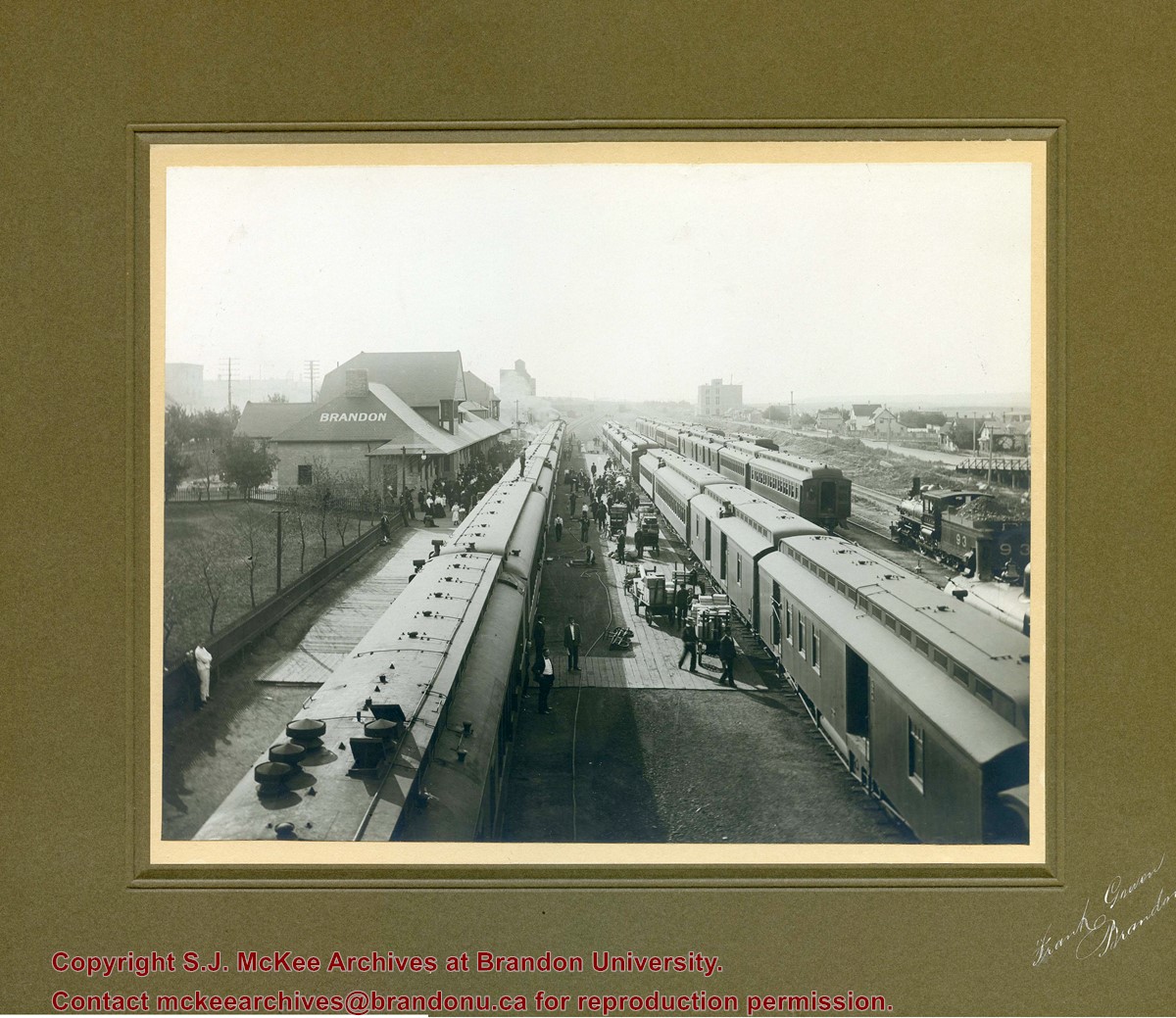
Photograph shows a CPR passenger trains at the old Brandon train station. Carts/trolleys appear to be loaded with wooden crates and metal milk containers. Photograph was likely taken from the 8th Street Bridge. The ramp to the 8th Street Bridge can be seen on the ride of the photograph, where residences line Assiniboine Avenue.
Name Access
Assiniboine Avenue - Early Scene
8th Street Bridge
Subject Access
residences
building exteriors
residential streets
railway stations
railroads
Storage Location
Hughes oversize drawer
Images
Show Less

Aerial view of 10th Street facing south from Princess Avenue

http://archives.brandonu.ca/en/permalink/descriptions8420
Part Of
Joseph H. Hughes collection
Description Level
Item
GMD
graphic
Date Range
c.1940
Accession Number
3-1997
Part Of
Joseph H. Hughes collection
Creator
Photographer: Jerrett Photo
Description Level
Item
Series Number
3-1997.1
Item Number
3-1997.1.42
Accession Number
3-1997
GMD
graphic
Date Range
c.1940
Physical Description
5.5" x 3.5" (b/w)
Material Details
postcard
Physical Condition
Red ink stain is on the front right corner of postcard
Scope and Content
Photograph shows 10th Street facing south from Princess Avenue. Visible landmarks and businesses include: Manitoba Power Commission (MPC)'s power sub-station, First Baptist Church, Wheat City Arena, and the grand stand at the Exhibition Grounds. The partial sign visible at the bottom of the photograph on the east side of 10th Street reads Yates and Neale, which refers to a plumbing and heating company that dissolved in 1943 to be replaced by Neale, Stothard and Chapman. Businesses on the west side of 10th Street include: Dominion Tire & Radio Co., Bolts Barber Shop, Elviss T.E. Co. Stables.
Notes
Information concerning Yates and Neale courtesy Jack Stothard. Writing on the front of the postcard reads: Brandon, Looking S.W., Jerrett Photo. This photograph shows a rare view of the 200-block of 10th Street.
Name Access
Manitoba Power Company
10th Street
Dominion Tire & Radio Co.
T.E. Elviss Co. Stables
First Baptist Church
Subject Access
downtowns
street scenes
Brandon business buildings & facilities before 1940
aerial views
building exteriors
residences
churches
Storage Location
RG 5 photograph storage drawer
Images
Show Less

Brandon College Platoon

http://archives.brandonu.ca/en/permalink/descriptions14257
Part Of
Joseph H. Hughes collection
Description Level
Item
GMD
graphic
Date Range
1916
Accession Number
3-1997
Part Of
Joseph H. Hughes collection
Creator
Photographer: Davidson Studio
Description Level
Item
Series Number
3-1997.1
Item Number
3-1997.1.66
Accession Number
3-1997
Other Numbers
Hughes #81
GMD
graphic
Date Range
1916
Physical Description
13.5" x 10.5" (b/w)
Material Details
on matting
Physical Condition
Photograph beginning to separate from matting
History / Biographical
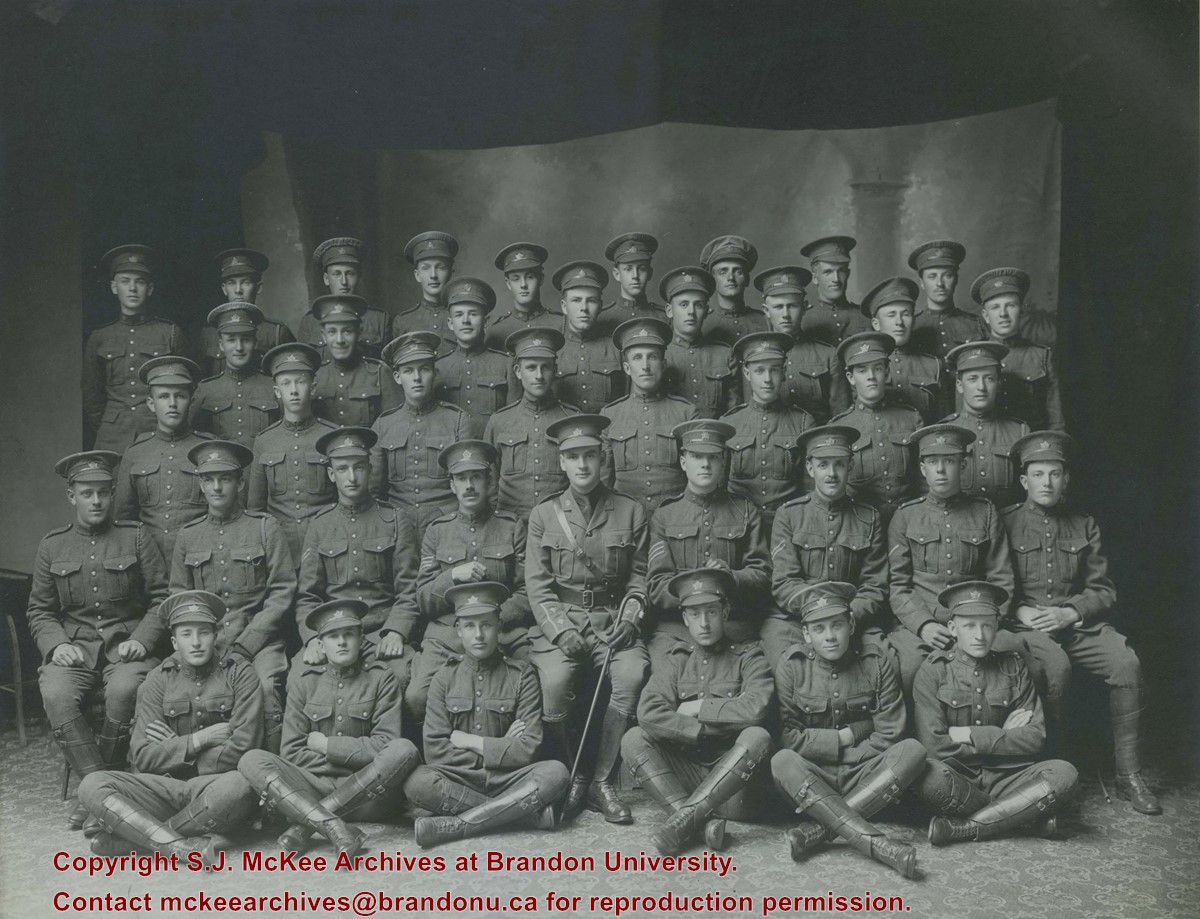
Brandon College established a Canadian Officer Training Corps (COTC) program in 1916 and had enough students for a platoon that would join the 196th Western Universities Battalion's B Company. COTC logs for in the SJ McKee Archives show that at least 40 men regularly attended classes on campus during the 1916 winter term. The Brandon Daily Sun published the names of 60 potential platoon recruits before they headed to Camp Hughes to train in the summer of 1916. Although Lt. J.R.C. Evans spearheaded the training of the COTC enlistees at Brandon College, he was found medically unfit for overseas service. In his stead, the son of the college's founder, Lt. William Carey McKee, lead the platoon to Camp Hughes where they joined the 196th Battalion. Of the 60 recruits identified in the local paper, 20 would not survive the war, including Lt. McKee. [ST/2016]
Scope and Content
Photograph shows a group of 40 men wearing WWI uniforms. The men have the Canada general service cap badge on their headdress. The officer in the centre of the group (i.e., the man with the cane) is J.R.C. Evans. The group of men are likely members of the first Brandon College Platoon, which joined the 196th Western Universities Battalion.
Name Access
J.R.C. Evans
Subject Access
portraits
First World War
Great War
Storage Location
Hughes oversize drawer
Related Material
Daly House Museum
The Clark Hall Scrapbook
Images
Show Less

First of several CNR trains of lumber for Hughes & Co.

http://archives.brandonu.ca/en/permalink/descriptions14245
Part Of
Joseph H. Hughes collection
Description Level
Item
GMD
graphic
Date Range
c.1900
Accession Number
3-1997
Part Of
Joseph H. Hughes collection
Description Level
Item
Series Number
3-1997.1
Item Number
3-1997.1.54
Accession Number
3-1997
Other Numbers
Hughes #55
GMD
graphic
Date Range
c.1900
Physical Description
7.25" x 5.75" (b/w)
Material Details
on matting
Physical Condition
water marks on matting, holes in corners
Scope and Content
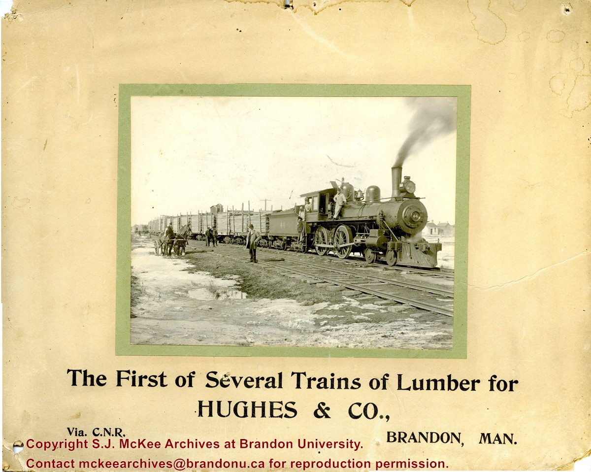
Photograph shows CNR train No.44 carrying loads of lumber. Engineers pose with the locomotive. Several men pose on the railway tracks. Snow and ice appear in the ditch.
Notes
Writing on the front of the photograph reads: The First of Several Trains of Lumber for HUGHES & CO., Via C.N.R., Brandon, Man. Photograph is stamped on the back: Huhges & Co. Ltd., 1009 Princess Ave., Brandon, Man.
Name Access
Hughes & Co.
Canadian National Railway
Subject Access
trains
lumber
lumbering
lumber manufacturing
winter
Transportation
Storage Location
Hughes oversize drawer
Images
Show Less
Part Of
Brandon University Photograph collection
Description Level
Item
GMD
graphic
Date Range
c. 1985
Part Of
Brandon University Photograph collection
Description Level
Item
Series Number
2.1
Item Number
BUPC 2.1.60
GMD
graphic
Date Range
c. 1985
Physical Description
5" x 3.5" (colour)
Scope and Content
Photograph shows the removal of one of the houses formerly located on 20th Street between Louise and Princess Avenues. The houses on those blocks were removed to create parking lots for the University. A Fed Zavislak Ltd. Well Drilling & Trucking pickup truck is visible at the curb.
Subject Access
campus photographs
Brandon streets
Images
Show Less
Part Of
Brandon University Photograph collection
Description Level
Item
GMD
graphic
Date Range
c. 1985
Part Of
Brandon University Photograph collection
Description Level
Item
Series Number
2.1
Item Number
BUPC 2.1.61
GMD
graphic
Date Range
c. 1985
Physical Description
5" x 3.5" (colour)
Scope and Content
Photograph shows the removal of one of the houses formerly located on 20th Street between Louise and Princess Avenues. The houses on those blocks were removed to create parking lots for the University.
Subject Access
campus photographs
Brandon streets
Images
Show Less

Brandon University campus construction

http://archives.brandonu.ca/en/permalink/descriptions8016
Part Of
Brandon University Photograph collection
Description Level
Item
GMD
graphic
Date Range
c. 1996
Part Of
Brandon University Photograph collection
Creator
Photographer: Sandy Black
Description Level
Item
Series Number
2.1
Item Number
BUPC 2.1.82
GMD
graphic
Date Range
c. 1996
Physical Description
4" x 6" (colour)
Scope and Content
View is northeast from the Brandon College Building. Photograph shows the inside of the Brandon College Building after it had been gutted and then partially rebuilt. The exterior fascade of the west side of the building can be clearly seen in this photograph. A number of houses on the east side of 200 block of 18th Street are also visible, as is the stone fence on Princess Avenue and the flag pole on the front lawn.
Subject Access
campus photographs
campus construction
Brandon streets
Images
Show Less

Northeast corner 10th Street and Princess Avenue, Brandon, Manitoba (1)

http://archives.brandonu.ca/en/permalink/descriptions8372
Part Of
Joseph H. Hughes collection
Description Level
Item
GMD
graphic
Date Range
1962
Accession Number
3-1997
Part Of
Joseph H. Hughes collection
Description Level
Item
Series Number
3-1997.1
Item Number
3-1997.1.3
Accession Number
3-1997
GMD
graphic
Date Range
1962
Physical Description
8" x 10" (b/w)
Physical Condition
good
Scope and Content
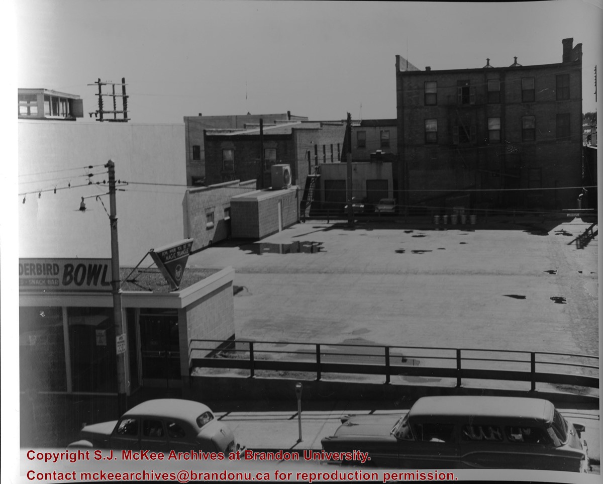
Photograph of an northeast corner 10th Street and Princess Avenue and the rear of buildings facing 200 block on 9th Street. The business in foreground is Thunderbird Bowl. The rear of the Brandon Inn is in the background.
Notes
Photograph dated from "Tara's Bulba," the movie playing at the Strand Theatre and similiar vehicles captured in the photograph.
Name Access
Thunderbird Bowl
10th Street
Subject Access
Brandon business buildings & facilities after 1940
bowling
Storage Location
RG 5 photograph storage drawer
Images
Show Less

Northeast corner 10th Street and Princess Avenue, Brandon, Manitoba (2)

http://archives.brandonu.ca/en/permalink/descriptions8374
Part Of
Joseph H. Hughes collection
Description Level
Item
GMD
graphic
Date Range
1962
Accession Number
3-1997
Part Of
Joseph H. Hughes collection
Description Level
Item
Series Number
3-1997.1
Item Number
3-1997.1.4
Accession Number
3-1997
GMD
graphic
Date Range
1962
Physical Description
8" x 10" (b/w)
Physical Condition
good
Scope and Content
Photograph shows a view of downtown Brandon from the northeast corner of 10th Street and Princess Avenue. Thunderbird Bowl is in the foreground. Painted advertisements on the sides of buildings include: The Mitrou's Cafe and Tea Room and Brandon Musical Supply Ltd. Vehicles parked on 10th Street are facing north.
Notes
Photograph dated from "Tara's Bulba," the movie playing at the Strand Theatre and similiar vehicles captured in the photograph.
Name Access
Thunderbird Bowl
Mitrou Building
Brandon Musical Supply Ltd.
10th Street
Subject Access
downtowns
Brandon business buildings & facilities after 1940
Storage Location
RG 5 photograph storage drawer
Images
Show Less

Aerial view: Brandon College

http://archives.brandonu.ca/en/permalink/descriptions594
Part Of
Brandon University Photograph collection
Description Level
Item
GMD
graphic
Date Range
[fall 1964?]
Part Of
Brandon University Photograph collection
Description Level
Item
Series Number
2.1
Item Number
BUPC 2.1.2
GMD
graphic
Date Range
[fall 1964?]
Physical Description
5" x 4" (b/w)
Scope and Content
Brandon College looking south from 19th Street. Photograph was taken after Flora Cowan Hall was built but before construction of the Education Building.
Subject Access
aerial photographs
campus photographs
campus buildings
Brandon streets
Images
Show Less

Aerial view - Brandon College looking southwest

http://archives.brandonu.ca/en/permalink/descriptions601
Part Of
Brandon University Photograph collection
Description Level
Item
GMD
graphic
Date Range
[1963-1966]
Part Of
Brandon University Photograph collection
Description Level
Item
Series Number
2.1
Item Number
BUPC 2.1.8
GMD
graphic
Date Range
[1963-1966]
Physical Description
5" x 4" (b/w)
Scope and Content
Image shows the Brandon College campus from 17th Street looking southwest. The photo was taken after the completion of the original Music Building in 1963, but construction of the Education Building. Also visible are a number of properties on the 200 block of 18th Street and the 200 block of 20th Street.
Subject Access
aerial photographs
campus photographs
campus buildings
Brandon streets
Images
Show Less

Aerial view - Brandon University campus

http://archives.brandonu.ca/en/permalink/descriptions7989
Part Of
Brandon University Photograph collection
Description Level
Item
GMD
graphic
Date Range
c. 2000
Part Of
Brandon University Photograph collection
Creator
Photograph commissioned by Brandon University and taken by Yourview Aerial Scenics Ltd.
Description Level
Item
Series Number
2.1
Item Number
BUPC 2.1.55
GMD
graphic
Date Range
c. 2000
Physical Description
6" x 4" (colour)
Scope and Content
View is southwest from approximatley 16th Street between Princess and Rosser Avenues. Photograph shows the Brandon University campus, as well as surrounding residential blocks, including Flemming, J.R. Reid and Vincent Massey schools.
Subject Access
aerial photographs
campus photographs
campus buildings
Brandon streets
Images
Show Less

Aerial view - Brandon University campus

http://archives.brandonu.ca/en/permalink/descriptions7990
Part Of
Brandon University Photograph collection
Description Level
Item
GMD
graphic
Date Range
c. 2000
Part Of
Brandon University Photograph collection
Creator
Photograph commissioned by Brandon University and taken by Yourview Aerial Scenics Ltd.
Description Level
Item
Series Number
2.1
Item Number
BUPC 2.1.56
GMD
graphic
Date Range
c. 2000
Physical Description
6" x 4" (colour)
Scope and Content
View is west southwest from approximatley 16th Street between Princess and Lorne Avenues. Photograph shows the Brandon University campus, as well as surrounding residential blocks between 16th and 23rd Streets, Princess and Louise Avenues..
Subject Access
aerial photographs
campus photographs
campus buildings
Brandon streets
Images
Show Less

Aerial view - Brandon University campus

http://archives.brandonu.ca/en/permalink/descriptions7991
Part Of
Brandon University Photograph collection
Description Level
Item
GMD
graphic
Date Range
c. 2000
Part Of
Brandon University Photograph collection
Creator
Photograph commissioned by Brandon University and taken by Yourview Aerial Scenics Ltd.
Description Level
Item
Series Number
2.1
Item Number
BUPC 2.1.57
GMD
graphic
Date Range
c. 2000
Physical Description
6" x 4" (colour)
Scope and Content
View is west from approximatley 17th Street between Lorne and Louise Avenues. Photograph shows a portion of the Brandon University campus (excluding the Education Building and anything north of it), as well as surrounding residential blocks from approximatley 17th Street to 22nd Street.
Subject Access
aerial photographs
campus photographs
campus buildings
Brandon streets
Images
Show Less

Aerial view - Brandon University campus

http://archives.brandonu.ca/en/permalink/descriptions7992
Part Of
Brandon University Photograph collection
Description Level
Item
GMD
graphic
Date Range
c. 1990
Part Of
Brandon University Photograph collection
Description Level
Item
Series Number
2.1
Item Number
BUPC 2.1.58
GMD
graphic
Date Range
c. 1990
Physical Description
5" x 3.5" (colour)
Scope and Content
View is west northwest from approximatley 16th Street and Louise Avenue. Photograph shows the Brandon University campus, prior to the Library Extension, and a large portion of the city to the west of the campus.
Subject Access
aerial photographs
campus photographs
campus buildings
Brandon streets
Images
Show Less

Aerial view - Brandon University campus

http://archives.brandonu.ca/en/permalink/descriptions7993
Part Of
Brandon University Photograph collection
Description Level
Item
GMD
graphic
Date Range
c. 1990
Part Of
Brandon University Photograph collection
Description Level
Item
Series Number
2.1
Item Number
BUPC 2.1.59
GMD
graphic
Date Range
c. 1990
Physical Description
5" x 3.5" (colour)
Scope and Content
View is northwest from approximatley 16th Street and Louise Avenue. Photograph shows the Brandon University campus, prior to the Library Extension, and a large portion of the city to the west of the campus.
Subject Access
aerial photographs
campus photographs
campus buildings
Brandon streets
Show Less

Brandon University campus construction

http://archives.brandonu.ca/en/permalink/descriptions8005
Part Of
Brandon University Photograph collection
Description Level
Item
GMD
graphic
Date Range
c. 1996
Part Of
Brandon University Photograph collection
Creator
Photographer: Sandy Black
Description Level
Item
Series Number
2.1
Item Number
BUPC 2.1.71
GMD
graphic
Date Range
c. 1996
Physical Description
4" x 6" (colour)
Scope and Content
View is northeast probably from the roof of McMaster Hall. Photograph shows the construction of the new roof on Clark Hall and the Brandon College Building. A portion of the east side of the 000 and 100 blocks of 18th Street, as well as the corner of 18th Street and Rosser Avenue are visible in the upper left hand corner. This includes the "Downtown Brandon" sign.
Subject Access
campus photographs
campus buildings
campus construction
Brandon streets
Images
Show Less

Brandon University campus construction

http://archives.brandonu.ca/en/permalink/descriptions8006
Part Of
Brandon University Photograph collection
Description Level
Item
GMD
graphic
Date Range
c. 1996
Part Of
Brandon University Photograph collection
Creator
Photographer: Sandy Black
Description Level
Item
Series Number
2.1
Item Number
BUPC 2.1.72
GMD
graphic
Date Range
c. 1996
Physical Description
6" x 4" (colour)
Scope and Content
View is north northeast probably from the roof of McMaster Hall. Photograph shows the construction of the new roof on Clark Hall and the Brandon College Building, as well as the construction of the extension to Clark Hall and the skywalk. Portions of the city as far north as the Assiniboine River are also visible.
Subject Access
campus photographs
campus buildings
campus construction
Brandon streets
Images
Show Less

Brandon University campus construction

http://archives.brandonu.ca/en/permalink/descriptions8018
Part Of
Brandon University Photograph collection
Description Level
Item
GMD
graphic
Date Range
c. 1996
Part Of
Brandon University Photograph collection
Description Level
Item
Series Number
2.1
Item Number
BUPC 2.1.84
GMD
graphic
Date Range
c. 1996
Physical Description
6" x 4" (colour)
Scope and Content
View is north northeast from the roof of McMaster Hall. Photograph shows the campus under construction during the renovation of the Brandon College Building and Clark Hall. The photograph was taken in late fall after the roof had been removed from the buildings but before the construction of the extension of Clark Hall. Construction materials litter the courtyard and driveway. The view looking north extends to The North Hill - a number of residential blocks, particularly to the northeast of 18th Street are visible. Buildings include the International Harvester Building and Kin Village.
Subject Access
campus photographs
campus buildings
campus construction
Brandon streets
Images
Show Less

Brandon University campus construction

http://archives.brandonu.ca/en/permalink/descriptions8020
Part Of
Brandon University Photograph collection
Description Level
Item
GMD
graphic
Date Range
c. 1996
Part Of
Brandon University Photograph collection
Creator
Photographer: Sandy Black
Description Level
Item
Series Number
2.1
Item Number
BUPC 2.1.86
GMD
graphic
Date Range
c. 1996
Physical Description
6" x 4" (colour)
Scope and Content
View is north northeast probably from the roof of McMaster Hall. Photograph shows the construction of the new roof on Clark Hall and the Brandon College Building, as well as the construction of the extension to Clark Hall and the skywalk. The view looking north extends to The North Hill - a number of residential blocks, particularly to the northeast of 18th Street are visible. Buildings include the International Harvester Building and Kin Village.
Subject Access
campus photographs
campus buildings
campus construction
Brandon streets
Images
Show Less

20 records – page 1 of 1.