Skip header and navigation

Revise Search

20 records – page 5 of 1.

Brandon Mental Health Centre - Aerial View

http://archives.brandonu.ca/en/permalink/descriptions9645
Part Of
RG 11 Lawrence Stuckey fonds
Description Level
Item
GMD
graphic
Date Range
1977
Accession Number
1-2002
Part Of
RG 11 Lawrence Stuckey fonds
Description Level
Item
Series Number
3.1
Item Number
1-2002.3.1G14
Accession Number
1-2002
GMD
graphic
Date Range
1977
Physical Description
3 1/2" x 5"
Material Details
Negative
Custodial History
For custodial history see the collection level description of the Lawrence Stuckey collection.
Scope and Content
Brandon Mental Health Centre
Notes
Aerial view [looking north]
Name Access
Brandon Mental Health Centre
Subject Access
hospitals
psychiatric hospitals
Brandon Hospitals
Repro Restriction
The McKee Archives is the copyright holder for the Stuckey materials.
Storage Location
Lawrence Stuckey collection
Images
Show Less

Rooftop view from Prince Edward Hotel

http://archives.brandonu.ca/en/permalink/descriptions13855
Part Of
Fred McGuinness collection
Description Level
Item
GMD
graphic
Date Range
1927
Accession Number
20-2009
Part Of
Fred McGuinness collection
Description Level
Item
Series Number
McG 9
Item Number
20-2009.166
Accession Number
20-2009
GMD
graphic
Date Range
1927
Physical Description
5" x 7" (b/w)
Material Details
reproduction
Custodial History
Donated to Fred McGuinness by G. Baldock in 1971
Scope and Content
Photograph shows a view from the rooftop of the Prince Edward Hotel. The south side of the Brandon Hotel (most recently the Brandon Inn) and a service station along Prince Avenue can be seen.
Notes
Writing on the back of photograph reads: across the street from roof of P.E. Hotel 1927
Name Access
Prince Edward Hotel
Brandon Hotel
Subject Access
hotels
downtown
Storage Location
RG 5 photograph storage drawer 2 (hanging photos)
Arrangement
From 2009 loose photos, from File 13
Images
Show Less

View from the roof of the old steam plant

http://archives.brandonu.ca/en/permalink/descriptions14357
Part Of
Brandon University Photograph Collection
Description Level
Item
GMD
graphic
Date Range
November 19, 1970
Part Of
Brandon University Photograph Collection
Creator
Photographer: Tom Donkersloot
Description Level
Item
Series Number
2.12
Item Number
BUPC 2.12.26
GMD
graphic
Date Range
November 19, 1970
Physical Description
4.25" x 3.25" (b/w)
History / Biographical
Donkersloot began working at Brandon University in 1970/1971 as the Clerk of Works. From 1973 until his retirement, he was the Director of Physical Plant. The 1960s campus expansion necessitated a large, updated heat source so a central steam plant fueled by coal was built north of the campus adjacent to the CPR rail lines on Pacific Avenue. A 25-year agreement was made between the University and John R. Brodie of the Great West Coal Company, which guaranteed BU lower coal prices tendered by the Canadian National and Canadian Pacific Railways on an annual basis. Brandon College Engineer John Kasiurak officially opened the Heating Plant on 24 January 1962. An extension and/or upgrade of the steam plant appears to have occurred in 1970. Until the 1990s, heat was piped underground to the campus from the Pacific Avenue Heating Plant but inspection standards were outpacing the maintenance and repairs required to keep the plant operating smoothly. Consequently, a new steam plant was built immediately adjacent to the University to the west of Darrach Hall on 20th Street. This building was essential to handling additional loads from the proposed library expansion. The original steam plant was subsequently sold.
Custodial History
Photograph was taken by Tom Donkersloot during construction and stored in albums in the Physical Plant H-Hut until they were transfered to the McKee Archives by Doug Duncalf in May 2008.
Scope and Content
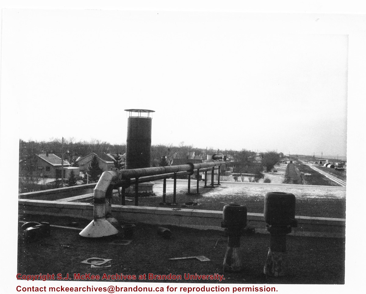
Photograph shows the roof of Brandon University's coal steam plant at 20th Street and Pacific Avenue, as well as the residential area nearby. The photograph appears to be looking west.
Notes
Donkersloot recorded the date and time each photograph was taken on the back of the photos.
Images
Show Less

North View of the Martyrs Memorial and Isle; The Oxford Almanack

http://archives.brandonu.ca/en/permalink/artworks668
Artist
Mackenzie, F
Form
print
Date
1849 (original)
Accession Number
0008
Artist
Mackenzie, F
Date
1849 (original)
Form
print
Description
Printed by University Press, Oxford
Dimensions
23 x 35 cm (etching)
Size Overall
77 x 63 cm
Medium
print from original etching
Condition
tear in paper c. 6 cm into image in TR area (1996)
Primary Support
paper
Secondary Support
glass, backing board; frame - wood painted white
Accession Number
0008
Show Less

Aerial view: Brandon College from 23rd Street

http://archives.brandonu.ca/en/permalink/descriptions602
Part Of
Brandon University Photograph collection
Description Level
Item
GMD
graphic
Date Range
[1963-1966]
Part Of
Brandon University Photograph collection
Description Level
Item
Series Number
2.1
Item Number
BUPC 2.1.9
GMD
graphic
Date Range
[1963-1966]
Physical Description
5" x 4" (b/w)
Scope and Content
Image is looking east northeast from approximately the 300 block of 23rd Street between Lorne and Louise Avenues. Photograph shows the Brandon College campus after the opening of the original Music Building in 1963, but before the construction of the Education Building in 1966. A number of house on the 300 blocks of 22nd and 21st Streets are visible in the foreground, with the A.E. McKenzie Seed Co., the Prince Edward Hotel and various grain elevators on the horizon.
Subject Access
aerial photographs
campus photographs
campus buildings
Brandon streets
Grain elevators
Images
Show Less

Aerial view: Brandon College and Original Music Building

http://archives.brandonu.ca/en/permalink/descriptions603
Part Of
Aerial views and campus photographs
Description Level
Item
GMD
graphic
Date Range
c. 1965
Part Of
Aerial views and campus photographs
Description Level
Item
Series Number
2.1
Item Number
2.1.10
GMD
graphic
Date Range
c. 1965
Physical Description
5" x 4" (b/w)
Scope and Content
View is west southwest from 17th Street and Princess Avenue. Photograph shows: Clark Hall, A.E. McKenzie Building and original Music Building.
Images
Show Less

Aerial view: Evans Theatre, McKenzie Building, WMCA

http://archives.brandonu.ca/en/permalink/descriptions609
Part Of
Aerial views and campus photographs
Description Level
Item
GMD
graphic
Date Range
c. 1970s
Part Of
Aerial views and campus photographs
Description Level
Item
Series Number
2.1
Item Number
2.1.16
GMD
graphic
Date Range
c. 1970s
Physical Description
10" x 8" (b/w)
Scope and Content
View is northwest. Photograph shows: J.R.C. Evans Lecture Theater, A.E. McKenzie Building, and Western Manitoba Centennial Auditorium (WMCA).
Images
Show Less

Aerial view: Brandon University campus covered in snow

http://archives.brandonu.ca/en/permalink/descriptions613
Part Of
Aerial views and campus photographs
Description Level
Item
GMD
graphic
Date Range
c. 1970s
Part Of
Aerial views and campus photographs
Description Level
Item
Series Number
2.1
Item Number
2.1.22
GMD
graphic
Date Range
c. 1970s
Physical Description
5" x 3.5" (b/w)
Physical Condition
Photograph is slightly overexposed.
Scope and Content
View is north northwest from the John R. Brodie Science Center (?). Photograph shows: Citizens' Science Building, Brandon College Building and Clark Hall, the Education Building and the driveway running in front of the buildings.
Images
Show Less

Aerial view: Flora Cowan, Gymnasium, Darrach Hall

http://archives.brandonu.ca/en/permalink/descriptions614
Part Of
Aerial views and campus photographs
Description Level
Item
GMD
graphic
Date Range
c. 1970
Part Of
Aerial views and campus photographs
Description Level
Item
Series Number
2.1
Item Number
2.1.18
GMD
graphic
Date Range
c. 1970
Physical Description
8" x 10" (b/w)
Scope and Content
View is southwest from the John R. Brodie Science Centre. Photograph shows: Flora Cowan Hall, the Brandon University Gymnasium, Darrach Hall, the Quill trailer and the Jeff Umphrey Centre.
Images
Show Less

Aerial view: Brandon College campus from north

http://archives.brandonu.ca/en/permalink/descriptions615
Part Of
Aerial views and campus photographs
Description Level
Item
GMD
graphic
Date Range
c. 1963
Part Of
Aerial views and campus photographs
Description Level
Item
Series Number
2.1
Item Number
2.1.23
GMD
graphic
Date Range
c. 1963
Physical Description
5" x 4" (b/w)
Scope and Content
View is north, taken from approximatley 19th Street and Rosser Avenue. Photograph shows: Clark Hall, the A.E. McKenzie Building, the J.R.C. Evans Lecture Theatre, H-Huts, Darrach Hall and Flora Cowan Hall, as well as a number of homes in the area.
Images
Show Less

Aerial view: Brandon College campus looking northwest

http://archives.brandonu.ca/en/permalink/descriptions616
Part Of
Aerial views and campus photographs
Description Level
Item
GMD
graphic
Date Range
c. 1963
Part Of
Aerial views and campus photographs
Description Level
Item
Series Number
2.1
Item Number
2.1.24
GMD
graphic
Date Range
c. 1963
Physical Description
5" x 4" (b/w)
Scope and Content
View is northwest from approximately the corner of 18th Street and Louise Avenue. Photograph shows the Brandon College campus after the completion of Flora Cowan Hall.
Notes
BUPC 2.1.20 is a larger version of this photograph.
Images
Show Less

Aerial view: Brandon College campus and Kinsmen Park

http://archives.brandonu.ca/en/permalink/descriptions621
Part Of
Aerial views and campus photographs
Description Level
Item
GMD
graphic
Date Range
c. 1962
Part Of
Aerial views and campus photographs
Description Level
Item
Series Number
2.1
Item Number
2.1.19
GMD
graphic
Date Range
c. 1962
Physical Description
10" x 8" (b/w)
Physical Condition
The bottom right hand corner has been torn off. Both portions of the photograph are stored together.
Scope and Content
View is northwest from approximately 17th Street and Victoria Avenue. Photograph shows: the Brandon College campus and the Kinsmen Park and baseball diamond. Taken during construction of Flora Cowan Hall but before the Gymnasium was built.
Images
Show Less

View from 1st street bridge looking west

http://archives.brandonu.ca/en/permalink/descriptions6438
Part Of
Alf Fowler collection
Description Level
Item
GMD
graphic
Date Range
ca. 1911
Accession Number
6-1999
Part Of
Alf Fowler collection
Creator
Davidson & Gowen
Description Level
Item
Item Number
6-1999.13
Accession Number
6-1999
GMD
graphic
Date Range
ca. 1911
Physical Description
9.5" x 7.5" (b/w)
Custodial History
See fonds level description of the Alf Fowler collection for custodial history.
Scope and Content
Photo shows Brandon from the 1st Street bridge, looking west. Massey-Harris Co. Limited and the Cockshutt Plow Company Limited are visible.
Storage Range
RG 5 Western Manitoba Manuscript collection - photograph storage drawer
Images
Show Less

View east-southeast from tower of Brandon Brewery

http://archives.brandonu.ca/en/permalink/descriptions6440
Part Of
Alf Fowler collection
Description Level
Item
GMD
graphic
Date Range
ca. 1911
Accession Number
6-1999
Part Of
Alf Fowler collection
Creator
Davidson & Gowen
Description Level
Item
Item Number
6-1999.15
Accession Number
6-1999
GMD
graphic
Date Range
ca. 1911
Physical Description
9.5" x 7.25" (b/w)
Custodial History
See fonds level description of the Alf Fowler collection for custodial history.
Scope and Content
Photo shows view east-southeast from tower of Brandon Brewery. Assiniboine Avenue and the west ramp of the Overhead bridge are visible.
Storage Range
RG 5 Western Manitoba Manuscript collection - photograph storage drawer
Images
Show Less

Northeast view from 100 block of Tenth Street

http://archives.brandonu.ca/en/permalink/descriptions9215
Part Of
RG 11 Lawrence Stuckey fonds
Description Level
Item
GMD
graphic
Date Range
June 27, 1963
Accession Number
1-2002
Part Of
RG 11 Lawrence Stuckey fonds
Creator
L.A. Stuckey
Description Level
Item
Series Number
3.1
Item Number
1-2002.3.1CA2(3)
Accession Number
1-2002
GMD
graphic
Date Range
June 27, 1963
Physical Description
2 1/2" x 2 1/2"
Material Details
Negative
Custodial History
For custodial history see the collection level description of the Lawrence Stuckey collection.
Scope and Content
Views from roof of Alexandra Block showing the 100 block of Tenth Street, east side; view northeast including Christie building.
Name Access
Northeast View from 100 Block of Tenth Street
Subject Access
downtowns
businesses
Brandon Street Scenes After 1940
Repro Restriction
The McKee Archives is the copyright holder for the Stuckey materials.
Storage Location
Lawrence Stuckey collection
Arrangement
[Mr. Stuckey put 5 negatives in the same envelope. We have separated them and numbered them CA2(1) to CA2(5).]
Images
Show Less

East view from 100 block of Tenth Street

http://archives.brandonu.ca/en/permalink/descriptions9216
Part Of
RG 11 Lawrence Stuckey fonds
Description Level
Item
GMD
graphic
Date Range
June 27, 1963
Accession Number
1-2002
Part Of
RG 11 Lawrence Stuckey fonds
Creator
L.A. Stuckey
Description Level
Item
Series Number
3.1
Item Number
1-2002.3.1CA2(4)
Accession Number
1-2002
GMD
graphic
Date Range
June 27, 1963
Physical Description
2 1/2" x 2 1/2"
Material Details
Negative
Custodial History
For custodial history see the collection level description of the Lawrence Stuckey collection.
Scope and Content
Views from roof of Alexandra Block showing the 100 block of Tenth Street, east side, including Brandon Hotel rear.
Name Access
East View from 100 Block of Tenth Street
Subject Access
downtowns
businesses
hotels
Brandon Street Scenes After 1940
Repro Restriction
The McKee Archives is the copyright holder for the Stuckey materials.
Storage Location
Lawrence Stuckey collection
Arrangement
[Mr. Stuckey put 5 negatives in the same envelope. We have separated them and numbered them CA2(1) to CA2(5).]
Images
Show Less

East view from 100 block of Tenth Street

http://archives.brandonu.ca/en/permalink/descriptions9217
Part Of
RG 11 Lawrence Stuckey fonds
Description Level
Item
GMD
graphic
Date Range
June 27, 1963
Accession Number
1-2002
Part Of
RG 11 Lawrence Stuckey fonds
Creator
L.A. Stuckey
Description Level
Item
Series Number
3.1
Item Number
1-2002.3.1CA2(5)
Accession Number
1-2002
GMD
graphic
Date Range
June 27, 1963
Physical Description
2 1/2" x 2 1/2"
Material Details
Negative
Custodial History
For custodial history see the collection level description of the Lawrence Stuckey collection.
Scope and Content
Views from roof of Alexandra Block showing the 100 block of Tenth Street, east side, including Brandon Hotel rear.
Name Access
East View from 100 Block of Tenth Street
Subject Access
downtowns
businesses
hotels
Brandon Street Scenes After 1940
Repro Restriction
The McKee Archives is the copyright holder for the Stuckey materials.
Storage Location
Lawrence Stuckey collection
Arrangement
[Mr. Stuckey put 5 negatives in the same envelope. We have separated them and numbered them CA2(1) to CA2(5).]
Images
Show Less

Mulgrave, Nova Scotia, view from Hadley's Hill

http://archives.brandonu.ca/en/permalink/descriptions13911
Part Of
Fred McGuinness collection
Description Level
Item
GMD
graphic
Date Range
[19--]
Accession Number
20-2009
Part Of
Fred McGuinness collection
Creator
Photographer: Fad Foto
Description Level
Item
Series Number
McG 9
Item Number
20-2009.221
Accession Number
20-2009
GMD
graphic
Date Range
[19--]
Physical Description
5.5" x 3.5" (b/w)
Material Details
postcard
Scope and Content
Photograph shows the harbour in the town of Mulgrave, located along the Strait of Canso in Guysborough County, Nova Scotia, Canada.
Notes
Writing on the front of the postcard reads: Mulgrave, N.S. View from Hadley's Hill - "Fad Foto"
Name Access
Mulgrave, Nova Scotia
Storage Location
RG 5 photograph storage drawer 2 (hanging photos)
Arrangement
From 20-2009 #4 plastic envelope #2
Images
Show Less

Special capital projects #2: Original building - exteriors and windows

http://archives.brandonu.ca/en/permalink/descriptions3573
Part Of
RG 6 Brandon University fonds
Description Level
File
GMD
textual records
Date Range
1977-1978
Accession Number
8-2005
Part Of
RG 6 Brandon University fonds
Description Level
File
Series Number
2.6
File Number
22
Accession Number
8-2005
GMD
textual records
Date Range
1977-1978
Physical Description
1 file
Scope and Content
File consists of requests for financial assistance from the Universities Grants Commission, correspondence and additiona financial information.
Storage Location
RG 6 Brandon University fonds Series 2: Board of Governors 2.6 Board Projects Box 1
Show Less

9th Street aerial view facing south, Brandon, Manitoba

http://archives.brandonu.ca/en/permalink/descriptions8419
Part Of
Joseph H. Hughes collection
Description Level
Item
GMD
graphic
Date Range
c. 1940
Accession Number
3-1997
Part Of
Joseph H. Hughes collection
Creator
Photographer: Jerrett Photo
Description Level
Item
Series Number
3-1997.1
Item Number
3-1997.1.41
Accession Number
3-1997
GMD
graphic
Date Range
c. 1940
Physical Description
5.5" x 3.5" (b/w)
Material Details
postcard
Physical Condition
good
Scope and Content
Postcard shows an aerial view of 9th Street facing south in Brandon, Manitoba. Visible businesses and landmarks include: Beaubier Hotel, YMCA/police station, the original CKX Radio station towers on 8th Street (est. 1928 - moved 1940), the old City Hall, Prince Edward Hotel, and the original Manitoba Power commission smokestack on 10th Street.
Notes
Writing on the front of the photograph reads: Brandon, Man., Jerrett Photo. This photograph shows a rare view of the 800-block between Rosser and Princess Avenues.
Name Access
Beaubier Hotel
City Hall
CKX
Prince Edward Hotel
Manitoba Power Company
Subject Access
downtowns
street scenes
Brandon business buildings & facilities before 1940
aerial views
building exteriors
Storage Location
RG 5 photograph storage drawer
Images
Show Less

20 records – page 5 of 1.