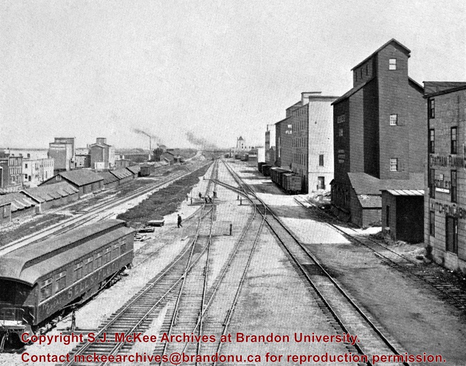
Stuckey's notes: In foreground is publicity coach of Sells-Floto Circus. On left the long row of domestic fuel coal sheds (many of which were later burned), Hanbury's Mill, elevators & Maple Leaf flour mill. On right elevator & Hanbury Hardware (in 1985 used by Christie School Supply).
Scope and Content
Photograph is looking east along the CPR tracks.
Notes
Corresponds with negative 1-2002.3.9.P11.
Repro Restriction
The McKee Archives is the copyright holder for the Stuckey materials.
Photograph shows a view from the rooftop of the Prince Edward Hotel. The south side of the Brandon Hotel (most recently the Brandon Inn) and a service station along Prince Avenue can be seen.
Notes
Writing on the back of photograph reads: across the street from roof of P.E. Hotel 1927
Donkersloot began working at Brandon University in 1970/1971 as the Clerk of Works. From 1973 until his retirement, he was the Director of Physical Plant.
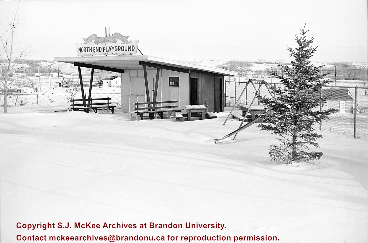
The 1960s campus expansion necessitated a large, updated heat source so a central steam plant fueled by coal was built north of the campus adjacent to the CPR rail lines on Pacific Avenue. A 25-year agreement was made between the University and John R. Brodie of the Great West Coal Company, which guaranteed BU lower coal prices tendered by the Canadian National and Canadian Pacific Railways on an annual basis. Brandon College Engineer John Kasiurak officially opened the Heating Plant on 24 January 1962. An extension and/or upgrade of the steam plant appears to have occurred in 1970.
Until the 1990s, heat was piped underground to the campus from the Pacific Avenue Heating Plant but inspection standards were outpacing the maintenance and repairs required to keep the plant operating smoothly. Consequently, a new steam plant was built immediately adjacent to the University to the west of Darrach Hall on 20th Street. This building was essential to handling additional loads from the proposed library expansion. The original steam plant was subsequently sold.
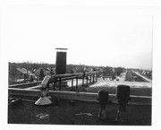
Custodial History
Photograph was taken by Tom Donkersloot during construction and stored in albums in the Physical Plant H-Hut until they were transfered to the McKee Archives by Doug Duncalf in May 2008.
Scope and Content
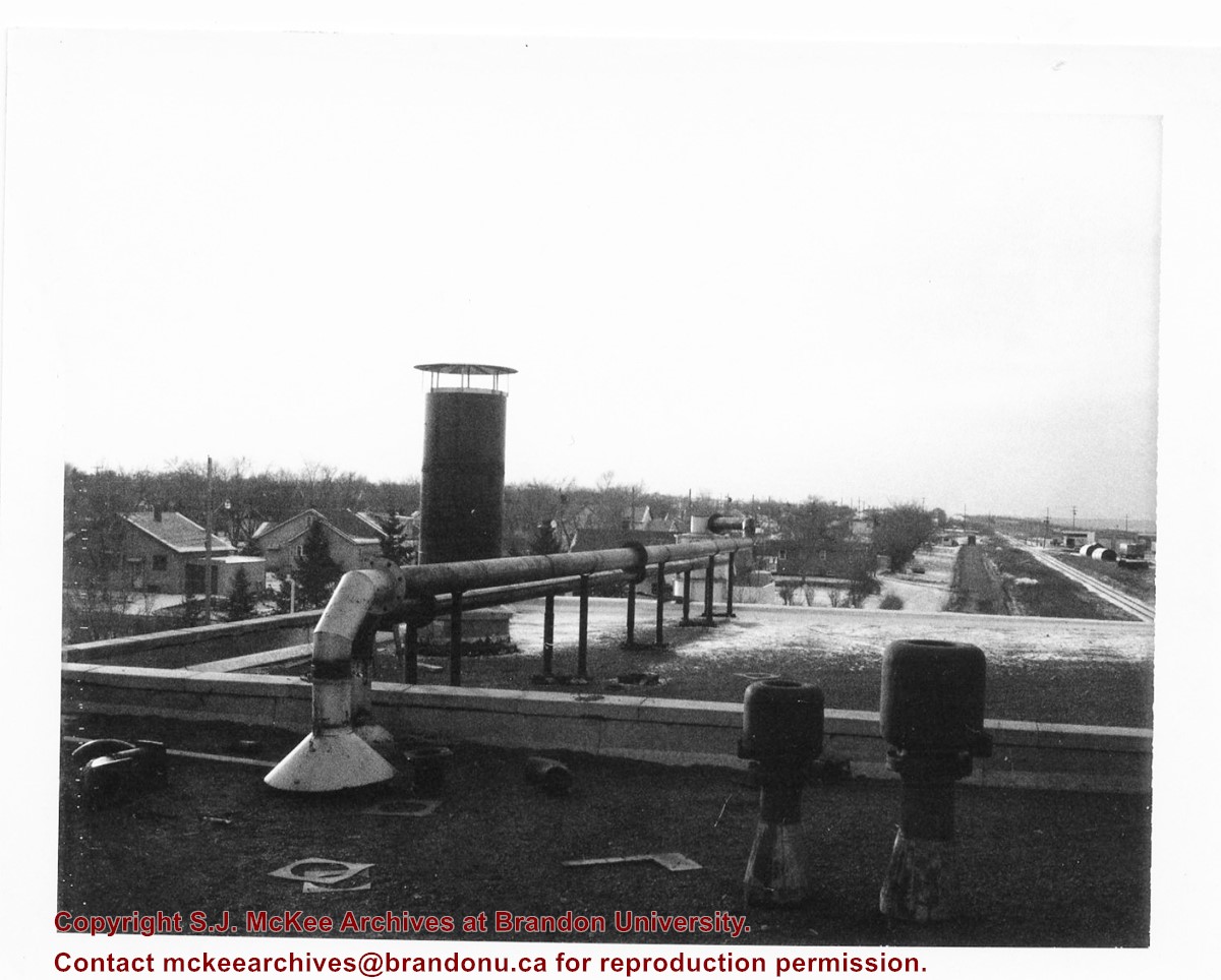
Photograph shows the roof of Brandon University's coal steam plant at 20th Street and Pacific Avenue, as well as the residential area nearby. The photograph appears to be looking west.
Notes
Donkersloot recorded the date and time each photograph was taken on the back of the photos.
View is west to McDiarmid Drive from approximately 16th Street between Princess and Louise Avenues. Photograph shows: Brandon College, Fleming School, Coronation Park, and West End Community Centre.
View is northwest from the corner of 18th Street and Louise Avenue. Photograph shows the Brandon College campus, the Steam Plant and Kinsmen Stadium. Flora Cowan Hall is under construction.
View is east southeast from approximately 22nd Street between Princess and Louise Avenues. Photograph shows: Brandon College, Stanley Park, Park School, Prince Edward Hotel, First Baptist Church, First Presbyterian Church, Wheat City Arena, First Church United, St. Paul's, Central United Church.
View is southeast from 21st Street and Princess Avenue. Photograph shows: Brandon College, Wheat City Arena, Armories, Reform (Knox) Church, Alexander School, Knox United Church, Kinsmen Playground, Kinsmen Stadium.
Image shows the Brandon College campus from 17th Street looking southwest. The photo was taken after the completion of the original Music Building in 1963, but construction of the Education Building. Also visible are a number of properties on the 200 block of 18th Street and the 200 block of 20th Street.
View is east northeast from approximately 22nd Street between Lorne and Louise Avenues. Photograph shows: Brandon College (before planting of trees in quadrangle and before the Education Building), McKenzie Seeds, Prince Edward Hotel, Central United (St. Paul's) Church, St. Augustine's Church.
View is east from approximatley 22nd Street between Lorne and Louise Avenues. Photograph shows: Darrach Hall, Flora Cowan Hall and the Citizens' Science Building, as well as a number of homes in the area.
ARCH 2: North Lauder Locale
The North Lauder locale has a long archaeological and geological history that is important for understanding the forces that shaped the region. Archaeological research in the locale shows that the area has been occupied by humans for at least the past 6,500 years. Environmental forces provided an area of diverse resources that attracted early peoples.
Environment of the Lauder Sandhills
The North Lauder locale is part of the greater Lauder Sandhills area. The glaciers that covered this region began to recede approximately 11,000 years ago leaving a large lake known as glacial Lake Hind. The Souris River, the Lauder Sandhills and the Oak Lake Aquifer are remnants of the environmental and geological forces that shaped the region.
The Lauder Sandhills region is characterized by a landscape of sand sheets and stabilized sand dunes interspersed with a variety of wetlands. This complex topographic and hydrological situation favoured the development of an island mosaic of mixed forest, wetland and meadow, surrounded by mixed grass prairie. The result was a large, isolated ecotone which provided a rich variety of subsistence resources for hunter-gatherers.
Research in the Lauder Sandhills
Archaeologists from Brandon University have been conducting research in the Lauder Sandhills since 1991. Research in the North Lauder locale has focused on the Atkinson site, a 6,500 year old hunter-gatherer site and Flintstone Hill.
The Atkinson site
The Atkinson site is one of the oldest excavated sites in Manitoba and has been Radiocarbon dated to 6,500 years before present. The Atkinson site is located on the bank of the Souris River and was discovered when a hearth (fire pit) was seen eroding out of the bank. Based on the date of the site and the kind of lithics (stone tools) present it is considered a Gowen occupation. The Atkinson site is evidence that bison hunters were active on the northern plains at a very early date. Similar sites have also been found on the High Plains in the U.S. and are referred to as the Mummy Cave Complex.
The Atkinson Site is of great importance as it is the first undisturbed site of this type to be excavated in Manitoba and extends the range of these sites south and east from the type-sites in central Saskatchewan.
Flintstone Hill
The geomorphology of the glacial Lake Hind Basin over the past 11,000 years is known primarily through the study of a cut bank along the Souris River. Flint Stone Hill contains the most complete stratigraphic record for the post-glacial period on the northern plains. The site has been extensively studied by geoarchaeologists, geologists and paleoenvironmentalists over many years and their findings have contributed to our understanding of the region.
The North Lauder locale Borden designations of Atkinson site DiMe-27 and Flintstone Hill site DiMe-26.
Borden System
Archaeological sites in Canada are identified by the Borden system, which is a uniform site designation system. The country is divided into grids based on latitude and longitude in blocks of 10 x 20 minutes. The first 4 letters indicate the block and the following numbers indicate the actual site. For example the area of the Lauder Sandhills in southwestern Manitoba is identified by the letters DM and the North Lauder locale within that area is DiMe. The Atkinson site is DiMe-27 and the Flintstone Hill site DiMe-26. As new sites are discovered they will be numbered sequentially.
Scope and Content
The Series has been divided into two sub-series, including (1) Atkinson site DiMe-27 and Flintstone Hill site DiMe-26.
Radiocarbon date reports have been scanned in multi-page PDF files.
History / Biographical
The North Lauder locale has a long archaeological and geological history that is important for understanding the forces that shaped the region. Archaeological research in the locale shows that the area has been occupied by humans for at least the past 6,500 years. Environmental forces provided an area of diverse resources that attracted early peoples.
Archaeologists from Brandon University have been conducting research in the North Lauder locale that has focused on the Atkinson site, a 6,500 year old hunter-gatherer site and Flintstone Hill.
The geomorphology of the glacial Lake Hind Basin over the past 11,000 years is known primarily through the study of a cut bank along the Souris River. Flintstone Hill contains the most complete stratigraphic record for the post-glacial period on the northern plains. The site has been extensively studied by geoarchaeologists, geologists and paleoenvironmentalists over many years and their findings have contributed to our understanding of the region.
Radiocarbon dates were obtained from the Atkinson site and Flintstone Hill.
Radiocarbon dating
The technique of radiocarbon dating was developed by Willard Libby and his colleagues at the University of Chicago in 1949.
Radiocarbon dating is used to estimate the age of organic remains from archaeological sites. Organic matter has a radioactive form of carbon (C14) that begins to decay upon death. C14 decays at a steady, known rate of a half life of 5,730 years. The technique is useful for material up to 50,000 years. Fluctuations of C14 in the atmosphere can affect results so dates are calibrated against dendrochronology. Radiocarbon dates are calibrated to calendar years.
Dates are reported in radiocarbon years or Before Present. Before Present refers to dates before 1950. The introduction of massive amounts of C14, due to atomic bomb and surface testing of atomic weapons, has widely increased the standard deviation on all dates after A.D. 1700 causing these dates to be unreliable.
Accelerated mass spectrometry can more accurately measure C14 with smaller samples and can date materials to 80,000 years.
Scope and Content
Sub sub series contains radiocarbon dates from: the Atkinson site and Flintstone Hill.
View is southwest from the north side of Princess Avenue. Photograph shows the north driveway entrance on campus. The original Music Building, the A.E. McKenzie Building, Clark Hall and part of the Brandon College Building are visible.
This bridge was condemned in the late 1930s but cyclists continued to use it until it was torn down (approximately 1940)
Until the early 1920s the Canadian Pacific Railway maintained a well and pumping station near the southeast corner of this bridge, which pumped water through a pipeline to a locomotive watering tank at Kemnay.
Custodial History
For custodial history see the collection level description of the Lawrence Stuckey collection.
Scope and Content
Assiniboine River Bridge North of Kemnay
Notes
[Mr. Stuckey put a negative and print in the same envelope. We have separated them, numbering the negative OB5(1) and the print OB5(1a).]
The Brandon Armoury is located at the southwest corner of Victoria Avenue and 11th Street.
Custodial History
Donated by Ron Brown.
Scope and Content
Photograph is a portrait of the Royal North-West Mounted Police C squadron returned from World War I. The photo was taken at the Brandon Armoury where the squadron was housed before being restationed.
Notes
Information on the photo was taken from G.F. Barker's Brandon: A City (p. 200).


.jpg?width=1200&404=no-img.jpg&watermark=wmk)
.jpg?width=180&404=no-img.jpg)
.jpg?width=1200&404=no-img.jpg&watermark=wmk)
.jpg?width=180&404=no-img.jpg)


.jpg%3fmaxheight%3d1000%26maxwidth%3d1000%26watermark%3dwmk&description=Assiniboine+River+Bridge+North+of+Kemnay)
.jpg%3fmaxheight%3d1000%26maxwidth%3d1000%26watermark%3dwmk&description=Assiniboine+River+Bridge+North+of+Kemnay)