Skip header and navigation

Revise Search

20 records – page 10 of 1.

Front Street, west end of Baldur, MB

http://archives.brandonu.ca/en/permalink/descriptions14405
Part Of
James Wall collection
Description Level
Item
GMD
graphic
Date Range
[1900-1904]
Accession Number
12-2004
Part Of
James Wall collection
Description Level
Item
Series Number
Box 2
Item Number
12-2004.12
Accession Number
12-2004
GMD
graphic
Date Range
[1900-1904]
Physical Description
6.6" x 4.75" (b/w)
Material Details
On matting (9" x 7")
Custodial History
See collection level description for the James Douglas Wall collection.
Scope and Content
Image of the west end of Front Street in Baldur, MB. Business and buildings in the photo include (L-R): Cleghorn's drug store, Fowlers, Tom Johnson's John Deer Shop, barber shop, Royal Bank (Odd Fellows Hall upstairs), Lee's Chinese Cafe, Hunters Hardware, Folwer Block, L. Curtis Block, Sexsmith Block - boarding house and sample room.
Subject Access
rural images
Storage Location
2004 accessions
Images
Show Less

10th street south from Pacific avenue

http://archives.brandonu.ca/en/permalink/descriptions6428
Part Of
Alf Fowler collection
Description Level
Item
GMD
graphic
Date Range
ca. 1911
Accession Number
6-1999
Part Of
Alf Fowler collection
Creator
Davidson & Gowen
Description Level
Item
Item Number
6-1999.3
Accession Number
6-1999
GMD
graphic
Date Range
ca. 1911
Physical Description
9" x 7" (b/w)
Custodial History
See fonds level description of the Alf Fowler collection for custodial history.
Scope and Content
Photo was taken of 10th Street from Pacific Avenue looking sourth. Visible businesses include: the Cecil Hotel; the Canadian Bank of Commerce; Campbell and Campbell; and the Bank of British North America
Storage Range
RG 5 Western Manitoba Manuscript collection - photograph storage drawer
Images
Show Less

Rosser avenue west from 7th street

http://archives.brandonu.ca/en/permalink/descriptions6429
Part Of
Alf Fowler collection
Description Level
Item
GMD
graphic
Date Range
ca. 1911
Accession Number
6-1999
Part Of
Alf Fowler collection
Creator
Davidson & Gowen
Description Level
Item
Item Number
6-1999.4
Accession Number
6-1999
GMD
graphic
Date Range
ca. 1911
Physical Description
9.25" x 7.25" (b/w)
Custodial History
See fonds level description of the Alf Fowler collection for custodial history.
Scope and Content
Photo was taken of Rosser Avenue from 7th Street looking west. Visible businesses include: ? and Ball; Vincent & MacPherson; W.N. Finlay; Christie's; J. Burchill; the Empire Hotel; and Fleming's Drug Store. A number of people and vehicles are visible on both sides of the street.
Notes
A digital scan of the photograph is available on a CD located in the Archives' office.
Storage Range
RG 5 Western Manitoba Manuscript collection - photograph storage drawer
Images
Show Less

9th street south from Pacific avenue

http://archives.brandonu.ca/en/permalink/descriptions6446
Part Of
Alf Fowler collection
Description Level
Item
GMD
graphic
Date Range
ca. 1911
Accession Number
6-1999
Part Of
Alf Fowler collection
Creator
Davidson & Gowen
Description Level
Item
Item Number
6-1999.21
Accession Number
6-1999
GMD
graphic
Date Range
ca. 1911
Physical Description
9" x 7" (b/w)
Custodial History
See fonds level description of the Alf Fowler collection for custodial history.
Scope and Content
Photo was taking from Pacific Avenue looking south down 9th Street. Visible in the photo are the Grand View Hotel and A.E. McKenzie Seeds Ltd.
Storage Range
RG 5 Western Manitoba Manuscript collection - photograph storage drawer
Images
Show Less

Rosser avenue east from 11th street

http://archives.brandonu.ca/en/permalink/descriptions6447
Part Of
Alf Fowler collection
Description Level
Item
GMD
graphic
Date Range
ca. 1911
Accession Number
6-1999
Part Of
Alf Fowler collection
Creator
Davidson & Gowen
Description Level
Item
Item Number
6-1999.22
Accession Number
6-1999
GMD
graphic
Date Range
ca. 1911
Physical Description
9.25" x 7" (b/w)
Custodial History
See fonds level description of the Alf Fowler collection for custodial history.
Scope and Content
Photo was taken of Rosser Avenue, looking east from 11th Street. Visible in the photo are the Merchant's Bank of Canada, A. Smith, and the Union Bank of Canada. A number of people and vehicles are also visible.
Storage Range
RG 5 Western Manitoba Manuscript collection - photograph storage drawer
Images
Show Less

100-block 10th Street, facing southwest

http://archives.brandonu.ca/en/permalink/descriptions8406
Part Of
Joseph H. Hughes collection
Description Level
Item
GMD
graphic
Date Range
c. 1950s
Accession Number
3-1997
Part Of
Joseph H. Hughes collection
Description Level
Item
Series Number
3-1997.1
Item Number
3-1997.1.28
Accession Number
3-1997
GMD
graphic
Date Range
c. 1950s
Physical Description
10" x 8" (b/w)
Physical Condition
good
Scope and Content
Photograph shows the west side of 10th Street between Rosser and Princess Avenues. Visible businesses include: Brandon News & Record Shop, Fashion Fabrics, Recreation Bowling & Billiards, Bottomley's, Barry Neill Men's Wear, Simpsons-Sears. Painted on the north face of the Strathcona Block are two advertisements, one for Sutherland and Robertson [Grocery] and the other for Boyd Electric Co. Ltd. Union Jack flags hang from some businesses and light standards.
Name Access
10th Street
Brandon News & Record Shop
Fashion Fabrics
Recreation Bowling and Billiards
Bottomley's
Barry Neill Men's Wear
Simpsons-Sears Ltd.
Sutherland and Robertson
Boyd Electric Co. Ltd.
Strathcona Block
Subject Access
downtowns
street scenes
Brandon business buildings & facilities after 1940
building exteriors
Storage Location
RG 5 photograph storage drawer
Images
Show Less

Southwest corner 10th Street and Rosser Avenue

http://archives.brandonu.ca/en/permalink/descriptions8409
Part Of
Joseph H. Hughes collection
Description Level
Item
GMD
graphic
Date Range
c. 1950
Accession Number
3-1997
Part Of
Joseph H. Hughes collection
Description Level
Item
Series Number
3-1997.1
Item Number
3-1997.1.31
Accession Number
3-1997
GMD
graphic
Date Range
c. 1950
Physical Description
10" x 8" (b/w)
Physical Condition
good
Scope and Content
Photograph shows the Kresge store on the southwest corner of 10th Street and Rosser Avenue. Other 10th Street businesses that are visible on the west side of the street include: James Richardson & Son Investments, Beneficial Finance and Loans, Bass' Storkland, Brandon News & Record Shop, Recreation Bowling and Billiards, and Bottomley's. The Welcome Brandon sign can be seen in the top right corner of the photograph.
Name Access
10th Street
Kresge
James Richardson & Sons
Beneficial Finance Co.
Bass Storkland
Brandon News & Record Shop
Recreation Bowling and Billiards
Bottomley's
Subject Access
downtowns
street scenes
Brandon business buildings & facilities after 1940
building exteriors
Storage Location
RG 5 photograph storage drawer
Images
Show Less

10th street power plant control room

http://archives.brandonu.ca/en/permalink/descriptions8764
Part Of
RG 11 Lawrence Stuckey fonds
Description Level
Item
GMD
graphic
Date Range
[n.d.]
Accession Number
1-2002
Part Of
RG 11 Lawrence Stuckey fonds
Creator
Clark J. Smith
Description Level
Item
Series Number
3.9
Item Number
1-2002.3.9.131
Accession Number
1-2002
GMD
graphic
Date Range
[n.d.]
Physical Description
8" x 10" (b/w)
Scope and Content
Photograph of the control room of the 10th Street Power Plant.
Repro Restriction
The McKee Archives is the copyright holder for the Stuckey materials.
Storage Location
RG 5 photograph storage drawer
Images
Show Less

10th street power plant control room

http://archives.brandonu.ca/en/permalink/descriptions8765
Part Of
RG 11 Lawrence Stuckey fonds
Description Level
Item
GMD
graphic
Date Range
[n.d.]
Accession Number
1-2002
Part Of
RG 11 Lawrence Stuckey fonds
Creator
Clark J. Smith
Description Level
Item
Series Number
3.9
Item Number
1-2002.3.9.132
Accession Number
1-2002
GMD
graphic
Date Range
[n.d.]
Physical Description
8" x 10" (b/w)
Scope and Content
Photograph of the control room of the 10th Street Power Plant.
Repro Restriction
The McKee Archives is the copyright holder for the Stuckey materials.
Storage Location
RG 5 photograph storage drawer
Images
Show Less

CPR eighteenth street crossing & signal tower

http://archives.brandonu.ca/en/permalink/descriptions8789
Part Of
RG 11 Lawrence Stuckey fonds
Description Level
Item
GMD
graphic
Date Range
1962
Accession Number
1-2002
Part Of
RG 11 Lawrence Stuckey fonds
Creator
Photographer: Lawrence Stuckey
Description Level
Item
Series Number
3.9
Item Number
1-2002.3.9.163
Accession Number
1-2002
GMD
graphic
Date Range
1962
Physical Description
6.5" x 4.5" (b/w)
History / Biographical
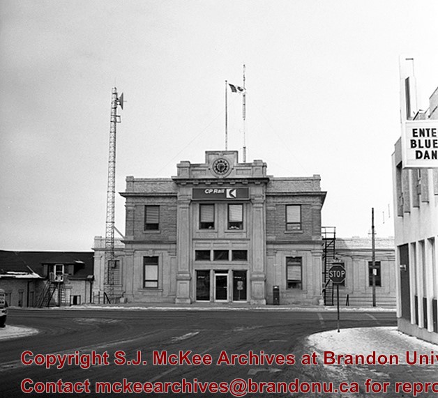
Stuckey's notes: Taken just before construction started on overpass. Towerman controlled crossing gates and switches and signals for all routes into and out of station and freight years. My grandfather Samuel Gilmour had for many years operated the previous tower which only operated the cross-ing gates and continued to operated the new tower for several years after it was built c. 1929. It was make obsolete with installation of Centralized Traffic Control in 1965. For better picture of tower see No. 53, engine 2911 in CP steam trains file.
Scope and Content
Photograph is looking northwest from just south of the train tracks on 18th Street. 18th Street to the North Hill is visible.
Notes
Corresponds with negative 1-2002.3.9.P20(1).
Repro Restriction
The McKee Archives is the copyright holder for the Stuckey materials.
Location Original
1-2002.3.1P20(1)
Storage Location
RG 5 photograph storage drawer
Images
Show Less

CPR station front from 10th street

http://archives.brandonu.ca/en/permalink/descriptions8793
Part Of
RG 11 Lawrence Stuckey fonds
Description Level
Item
GMD
graphic
Date Range
January 16, 1981
Accession Number
1-2002
Part Of
RG 11 Lawrence Stuckey fonds
Creator
Photographer: Lawrence Stuckey
Description Level
Item
Series Number
3.9
Item Number
1-2002.3.9.167
Accession Number
1-2002
GMD
graphic
Date Range
January 16, 1981
Physical Description
6.5" x 4.5" (b/w)
History / Biographical
Stuckey's notes: Built 1911.
Scope and Content
Photograph is looking north down 10th Street and shows the front of the CPR Station located on the north side of Pacific Avenue.
Notes
Corresponds with negative 1-2002.3.9.P22.
Repro Restriction
The McKee Archives is the copyright holder for the Stuckey materials.
Location Original
1-2002.3.1P22
Storage Location
RG 5 photograph storage drawer
Images
Show Less

CPR "Dominion" Under First Street Bridge

http://archives.brandonu.ca/en/permalink/descriptions9158
Part Of
RG 11 Lawrence Stuckey fonds
Description Level
Item
GMD
graphic
Date Range
[ca. 1945]
Accession Number
1-2002
Part Of
RG 11 Lawrence Stuckey fonds
Creator
L.A. Stuckey
Description Level
Item
Series Number
3.1
Item Number
1-2002.3.1BA3
Accession Number
1-2002
GMD
graphic
Date Range
[ca. 1945]
Physical Description
3 1/2" x 5"
Material Details
Negative
Custodial History
For custodial history see the collection level description of the Lawrence Stuckey collection.
Scope and Content
CPR No. 3, the westbound "Dominion", with engine 2829 under 1st Street Bridge
Notes
View includes former Empire Brewery, [then] in use by Bell Bottling Co.; Safe crossing over the CPR eliminated the need for a flagman. "Telltails" warn switchmen riding on top of railcars of low overhead clearance. Old Empire Brewery was (late 1950's) a feed mill, making grain feeds for livestock.
Name Access
CPR "Dominion" Under First Street Bridge
Empire Brewery
Subject Access
manmade geographic features
bridges
Transportation
rail transportation
railways
trains
passenger trains
Brandon Second First-Street Bridge
Repro Restriction
The McKee Archives is the copyright holder for the Stuckey materials.
Storage Location
Lawrence Stuckey collection
Images
Show Less

Assiniboine Ave. Ramp to First Street Bridge

http://archives.brandonu.ca/en/permalink/descriptions9159
Part Of
RG 11 Lawrence Stuckey fonds
Description Level
Item
GMD
graphic
Date Range
November 1937
Accession Number
1-2002
Part Of
RG 11 Lawrence Stuckey fonds
Creator
Geo. Harris
Description Level
Item
Series Number
3.1
Item Number
1-2002.3.1BA4
Accession Number
1-2002
GMD
graphic
Date Range
November 1937
Physical Description
3 1/2" x 5"
Material Details
Negative
Custodial History
For custodial history see the collection level description of the Lawrence Stuckey collection.
Scope and Content
Assiniboine Avenue ramp to First Street bridge, including CPR Extra 5178 West
Notes
Copy: LAS
Name Access
Assiniboine Ave. Ramp to FIrst Street Bridge
Subject Access
manmade geographic features
bridges
Transportation
rail transportation
railways
trains
Brandon Second First-Street Bridge
Repro Restriction
The McKee Archives is the copyright holder for the Stuckey materials.
Location Copy
1-2002.3.9.103
Storage Location
Lawrence Stuckey collection
Images
Show Less

VIA No. 109 Under First Street Bridge

http://archives.brandonu.ca/en/permalink/descriptions9173
Part Of
RG 11 Lawrence Stuckey fonds
Description Level
Item
GMD
graphic
Date Range
March 14, 1982
Accession Number
1-2002
Part Of
RG 11 Lawrence Stuckey fonds
Creator
L.A. Stuckey
Description Level
Item
Series Number
3.1
Item Number
1-2002.3.1BB4
Accession Number
1-2002
GMD
graphic
Date Range
March 14, 1982
Physical Description
2 1/2" x 2 1/2"
Material Details
Negative
Custodial History
For custodial history see the collection level description of the Lawrence Stuckey collection.
Scope and Content
Westbound VIA (CPR) train No. 109, engine 6508, with First Street bridge and brewery
Name Access
VIA No. 109 Under First Street Bridge
Subject Access
manmade geographic features
bridges
Transportation
rail transportation
railways
trains
passenger trains
Brandon Third First-Street Bridge
Repro Restriction
The McKee Archives is the copyright holder for the Stuckey materials.
Storage Location
Lawrence Stuckey collection
Images
Show Less

Asylum Patients Crossing the First Street Bridge

http://archives.brandonu.ca/en/permalink/descriptions9649
Part Of
RG 11 Lawrence Stuckey fonds
Description Level
Item
GMD
graphic
Date Range
November 5, 1910
Accession Number
1-2002
Part Of
RG 11 Lawrence Stuckey fonds
Description Level
Item
Series Number
3.1
Item Number
1-2002.3.1G19
Accession Number
1-2002
GMD
graphic
Date Range
November 5, 1910
Physical Description
3 1/2" x 5"
Material Details
Negative
History / Biographical
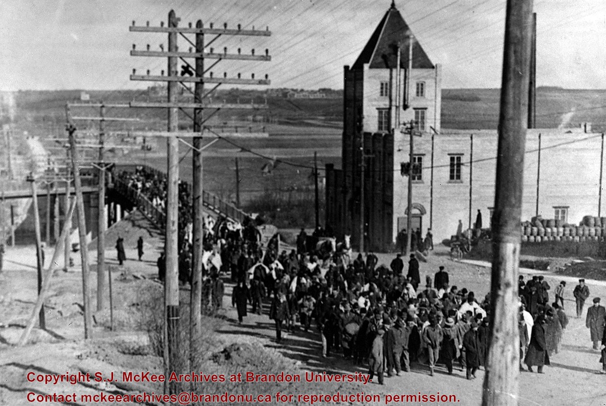
Seeking temporary housing, a parade of patients walked from the Brandon Asylum to the Winter Fair Building (located on the 500 block of 10th Street) the day after fire completely destroyed the asylum.
This photo shows the First Street Bridge as built and opened in 1909.
Note the pile of kegs next to the Empire Brewery. [The building was then] owned by Dave Weiss of Brandon Scrap Iron & Metals Recycling Co.
Custodial History
For custodial history see the collection level description of the Lawrence Stuckey collection.
Scope and Content
Brandon asylum patients crossing the First Street Bridge
Name Access
Brandon Asylum for the Insane
Subject Access
hospitals
psychiatric hospitals
Brandon Hospitals
Repro Restriction
The McKee Archives is the copyright holder for the Stuckey materials.
Storage Location
Lawrence Stuckey collection
Images
Show Less

CPR 18th Street crossing & signal tower

http://archives.brandonu.ca/en/permalink/descriptions9943
Part Of
RG 11 Lawrence Stuckey fonds
Description Level
Item
GMD
graphic
Date Range
1962
Accession Number
1-2002
Part Of
RG 11 Lawrence Stuckey fonds
Creator
L.A. Stuckey
Description Level
Item
Series Number
3.1
Item Number
1-2002.3.1P20(1)
Accession Number
1-2002
GMD
graphic
Date Range
1962
Physical Description
2 1/2" x 2 1/2"
Material Details
Negative
History / Biographical
The Towerman controlled the crossing gates, [as well as] switches and signals for all routes into and out of the station and freight yards. [Mr. Stuckey's] grandfather, Samuel Gilmour, operated the previous tower for many years (which only operated the crossing gates), and continued to operate the new tower for several years after it was built (ca. 1929). This tower was made obsolete with the installation of Centralized Traffic Control in 1965.
Custodial History
For custodial history see the collection level description of the Lawrence Stuckey collection.
Scope and Content
Canadian Pacific Railway's18th Street crossing & signal tower.
Notes
Photo taken just before construction started on overpass
For a better picture of this tower see photo No. 53 (engine 2911) in CPR steam trains file
Name Access
CPR crossing & signal towers
Subject Access
crossing towers
signal towers
railroads
railways
Canadian Pacific Railway in Brandon
Repro Restriction
The McKee Archives is the copyright holder for the Stuckey materials.
Location Copy
1-2002.3.9.163
Storage Location
Lawrence Stuckey collection
Arrangement
[Mr. Stuckey numbered two envelopes P20. We have kept the same number but designated the first envelope P20(1) and the contents of the second envelope P20(2) and P20(3).]
Images
Show Less

Aerial view: Brandon College from 23rd Street

http://archives.brandonu.ca/en/permalink/descriptions602
Part Of
Brandon University Photograph collection
Description Level
Item
GMD
graphic
Date Range
[1963-1966]
Part Of
Brandon University Photograph collection
Description Level
Item
Series Number
2.1
Item Number
BUPC 2.1.9
GMD
graphic
Date Range
[1963-1966]
Physical Description
5" x 4" (b/w)
Scope and Content
Image is looking east northeast from approximately the 300 block of 23rd Street between Lorne and Louise Avenues. Photograph shows the Brandon College campus after the opening of the original Music Building in 1963, but before the construction of the Education Building in 1966. A number of house on the 300 blocks of 22nd and 21st Streets are visible in the foreground, with the A.E. McKenzie Seed Co., the Prince Edward Hotel and various grain elevators on the horizon.
Subject Access
aerial photographs
campus photographs
campus buildings
Brandon streets
Grain elevators
Images
Show Less

Rosser Avenue and 8th Street during winter storm

http://archives.brandonu.ca/en/permalink/descriptions13706
Part Of
Fred McGuinness collection
Description Level
Item
GMD
graphic
Date Range
1906
Accession Number
20-2009
Part Of
Fred McGuinness collection
Description Level
Item
Series Number
McG 9
Item Number
20-2009.16
Accession Number
20-2009
GMD
graphic
Date Range
1906
Physical Description
6.5" x 4.25" (b/w)
Material Details
on matting
Physical Condition
Photographs have been glued to a backing board that has warped over time
Custodial History
On 16 November 1906, Manitoba was hit by a severe winter storm that began that Thursday evening and extended through the weekend. The Brandon Daily Sun ("Storm Extends Over a Large Territory," 17 Nov. 1906, 1) reported that rail and telegraph services had been disrupted, country roads were impassable, and business in town was at a stand still. Following the weekend, the daily reported the blizzard was one of the greatest in recent memory. CPR trains had been caught in drifts by Carberry and an express car had caught fire and was destroyed ("Worst Storm in Many Years," Brandon Daily Sun, 19 Nov. 1906, 1).
Scope and Content
Photograph shows street view of north side of Rosser Avenue, primarily the 700 block. The Fleming Block, Beaubier Block and its Empire Hotel, A.M. Percival (a grocer), the Brandon Hardware Company (600 block), and the Arlington Hotel (500 block) are visible along the north side of the avenue. The Bank of Hamilton Building on the southeast corner of 8th Street and Rosser appears to be under construction. The streets are muddy and a horse and buggy is traveling west on Rosser Avenue.
Notes
Writing on the front of the photograph matting reads: during the great storm of November 16 1906, 341. The photograph appears to be taken from the interior of a builing on the southwest corner of 7th Street and Rosser Avenue. Page appears to be from a photo album.
Name Access
Fleming Block
8th Street
Rosser Avenue
Subject Access
Street scene
downtown
storefronts
storms
winter
Storage Location
RG 5 photograph storage drawer 2 (hanging photos)
Images
Show Less

Queen's Hotel on the corner of 10th Street and Rosser Avenue

http://archives.brandonu.ca/en/permalink/descriptions13778
Part Of
Fred McGuinness collection
Description Level
Item
GMD
graphic
Date Range
1883
Accession Number
20-2009
Part Of
Fred McGuinness collection
Description Level
Item
Series Number
McG 9
Item Number
20-2009.89
Accession Number
20-2009
GMD
graphic
Date Range
1883
Physical Description
7.25" x 4.25" (b/w)
Material Details
on matting
Physical Condition
Left hand corner of mat is bent. Mock-up instructions are written in pencil at the bottom right hand corner. Portions of the photograph itself are marked with pen.
History / Biographical
The Queen's Hotel was located on the corner of Rosser Avenue and Tenth Street (Steen & Boyce, 1882. Brandon, Manitoba, Canada and Her Industries. Steen & Boyce Publishers Printers & Binders, 81.). Therefore this photo appears to display Rosser Avenue looking east. P.E. 11/06/09
Scope and Content
Photograph shows early Rosser Avenue under construction between 9th Street and 10th Street in the 1880s. Buildings that line the avenue are wood framed and there are wooden boardwalks in front of a few structures. On the north side of Rosser Avenue signs for Fortier & Bucke Commision Agents and Transit House (Hotel) can be seen. On the south side of Rosser Avenue, the Queen's Hotel and Robinson Brothers and Company groceries and dry goods store are open for business. A family appears to be standing on the stoop at the dry goods store. A boy is lounging in the entryway of the Queen's Hotel. A man is standing on a wooden plank that extends across the dirt road of Rosser Avenue between the dry goods store and the commission agents' shop.
Notes
The back of the photograph reads: FRED McGUINNESS
Name Access
Queen's Hotel
Rosser Avenue
Fortier & Bucke Commision Agents
Transit House
Robinson Brothers and Company
Subject Access
downtown
construction
Brandon Street Scenes Before 1940
hotels
hardware stores
street scenes
store exteriors
building exteriors
grocery stores
general stores
dry goods
Storage Location
RG 5 photograph storage drawer 2 (hanging photos)
Related Material
Lawrence Stuckey collection 1-2002.3.1C17
Images
Show Less

Stores near the corner of Rosser Avenue and 6th Street

http://archives.brandonu.ca/en/permalink/descriptions13783
Part Of
Fred McGuinness collection
Description Level
Item
GMD
graphic
Date Range
1881-1882
Accession Number
20-2009
Part Of
Fred McGuinness collection
Description Level
Item
Series Number
McG 9
Item Number
20-2009.94
Accession Number
20-2009
GMD
graphic
Date Range
1881-1882
Physical Description
9.25" x 6.25" (b/w)
Material Details
on matting
Physical Condition
Corners of photograph mat are bent. Picture is cracked.
Scope and Content
Photograph shows an early view of Brandon's 6th Street in the 1880s. The Winter & O'Neail Groceries & Provisions and James Smart Hardware storefronts have been photographed. A street sign designating 6th Street can be seen below the Winter & O'Neail sign. A horse and cart is parked in front of the grocery store. A number of men wearing hats and jackets are standing along the boardwalk while posing for the picture. Lumber/timber saws are displayed in teh windows of the hardware store.
Notes
Front of photograph reads: 6th Street, Brandon, Manitoba, 1881-1882, Entrance [to Winter & O'Neail] corner of Rosser Ave & 6th Street.
Name Access
James Smart Hardware store
Winter & O'Neail Groceries and Provisions
6th Street
Subject Access
downtown
hardware stores
Pioneers
dry goods
street scenes
Brandon Street Scenes Before 1940
grocery stores
Storage Location
RG 5 photograph storage drawer 2 (hanging photos)
Images
Show Less

20 records – page 10 of 1.