BRANDON COLLEGE BUILDING
The construction of the Brandon College Building, also known as the Original Building, was primarily financed by Mr. and Mrs. William Davies, a Toronto based Baptist meat packer, and his sister Mrs. Emily Davies, also of Toronto, who pledged $5,000 a year for five years to the new Baptist College. Four city blocks between 18th and 20th streets were purchased for the College campus and the tender of Messrs. T.M. Harrington of Winnipeg was accepted in the spring of 1900; Mr. Hugh McCowan of Winnipeg appointed as architect. Mrs. Davies laid the cornerstone for the Brandon College Building on July 13, 1900.
The Brandon College Building was conceived as a substantial five story brick structure with a stone basement. The Tyndall Manitoba quarries, located thrity miles northeast of Winnipeg, supplied the stone and presented the College with the stone steps at the main entrance. The basement contained the dining room, kitchen, laundry, furnace room, a science laboratory, and maids' rooms. The first floor housed the reception room, office, library, four classrooms and the teachers' cloak rooms. The second floor had five classrooms, a reading room, five rooms for resident students and a resident teacher. Teachers' rooms and seventeen rooms for students comprised the third floor; and additional thirteen rooms for residents took up the fourth floor. The residence was to house 70 men. The total cost of the building and furnishings was $44,000. The Brandon College Building was ready for occupancy by October 1, 1901.
CLARK HALL
The cornerstone of Clark Hall was laid by Mrs. A.P. McDiarmid, wife of the Principal of Brandon College, on May 24, 1906. The residence was officially opened on Thanksgiving Day, October 18, of the same year. The construction of the building grew our of a demand for a ladies' college. A canvass made in Eastern Canada had resulted in subscriptions totaling $10,000. When Dr. McDiarmid reported the results of the canvass to the Chairman of the Board, Dr. C.W. Clark of Winnipeg, Clark proposed that he and his wife be allowed to provided the balance of the funds, some $30,000. While presenting the building at the opening ceremony, Clark stated that the reason for his donation was his belief in the power of cultured womanhood - he believed "that refined and Christian mothers were the strength of a nation and that he wished to see in Brandon a chool of learning for women in which every Christian virtue and grace might be illustrated."
Clark Hall was built immediately north of the Brandon College Building and was connected to it by classrooms and the iron door with its door bell, which was rung by gentlemen before being admitted. It is a five story brick building, with fittings of imported Georgia pine. In the basement was the gymnasium, studios and maids' rooms. On the main floor was a spacious reception room furnished by the Honorable A.C. Rutherford, the Premier of Alberta and the Lady Principal's suite, furnished by Mrs. N. Wolverston, wife of the treaurer of the College Board. Music studios and the offices of the resident matron were also on the main floor. The second and third floors were dormitories. The fourth floor was meant to be art studios, but due to registration demands, it was divided into students' rooms. The residence was designed to house fifty students and seven teachers. Piano practice areas were also designated on the west side of the building and on the groundlevel half way between the basement and the first floor.
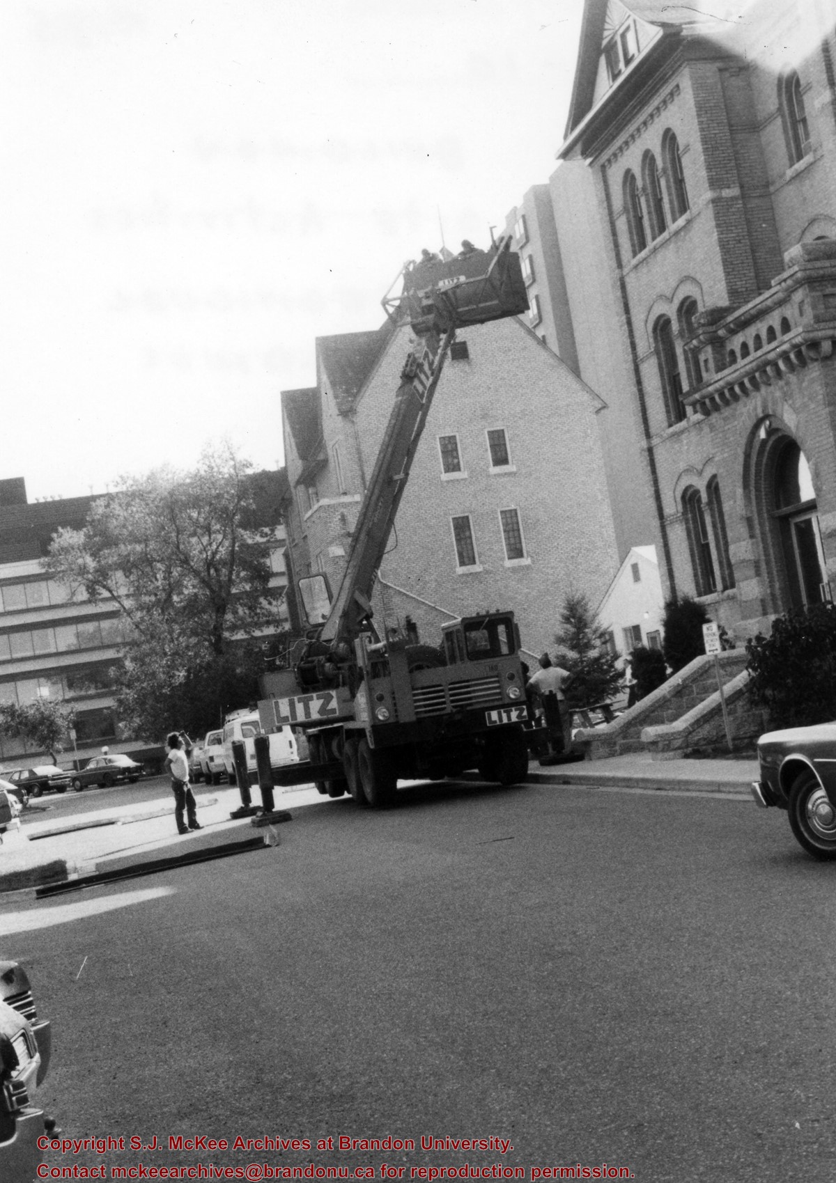
BRANDON COLLEGE BUILDING AND CLARK HALL RESTORATION PROJECT
By the early 1990s, it was clear that major reconstruction work on the Brandon College Building and Clark Hall was necessary if the buildings were to remain in use. The alternative was to demolish both buildings and construct a new central administrative structure for the campus. Because of the historic character of the two original campus buildings, the decision was taken to mount a complete restoration of the structures that involved a complete removal of everything except for the surrounding brick fascade and the construction of new buildings within the old external walls. This project was financed by the Provincial government of Manitoba, who granted the University approximatley 10 million dollars. The Chief Architect for the restoration was George Cibinal. Work began in 1996 and was completed by the fall of 1997. In addition to the restoration of the Brandon College Building and Clark Hall, a new entrance was built on the west side of the buildings, as well as an addition to Clark Hall, which included a skywalk connecting it to the A.E. McKenzie Building.
Scope and Content
Sub-series consists of photographs of the Brandon College Building and Clark Hall.
Notes
History/Bio information was taken from Brandon College: A History, 1899-1967 by C.G. Stone and F. Joan Garnett (Brandon, Manitoba: Brandon University, 1969), chapters 2 and 3. Tom Mitchell provided history/bio information on the restoration project.
The Citizens' Science Building was built in 1922 and financed by Brandon citizens. It was renamed the Knowles-Douglas Student Union Centre c. 1984 in honour of Brandon College graduates Stanley Knowles and Tommy Douglas, both of the Class of 1930. The Knowles-Douglas Addition was completed in 1987.
Scope and Content
Sub-series consists of photographs of the Citizens' Science Building and the Knowles-Douglas buildings, which include the Knowles-Douglas Student Union Centre and the Knowles-Douglas Addition.
The Gymnasium is located on the southside of Louise Avenue at the corner of 20th Street. It was completed in 1965 and houses the Athletic programme, which includes both intercollegiate sports and intermural sports and recreation. In the 1960s, it was also the venue for student dances and performers, including Gordon Lightfoot, the Mitchell Trio, the Guess Who and others. Convocation was also held in the Gym for a number of years. In 2007, a financial campaign was launched to raise money for extensive rennovations to the Gym.
Scope and Content
Sub-series consists of photographs of the Gymnasium.
The Original Music Building was completed in 1963. The School of Music moved to the Queen Elizabeth II Music Building in 1985. From c.1986 until 1997, the Original Music Building housed Student Services. Since 1997, the building has been used by the School of Health Studies; a new segment was added to the Original Music Building in 2003 to create the Health Studies Complex.
Scope and Content
Sub-series consists of photographs of the Original Music Building and the Queen Elizabeth II Music Building.
Notes
Queen Elizabeth II Music Building has been abbreviated to QEII Music Building.
Arrangement
All photographs of the Health Studies Complex, which includes the Original Music Building, are part of BUPC sub-series 2.10.
The John R. Brodie Science Centre was completed in 1971, with the official opening on May 7, 1972. It is located in the southeast corner of the campus and houses the Faculty of Science. The Brodie Building was named for John R. Brodie, a Brandon man who donated $250,000 to Brandon College in 1963 with the stipulation that the money be used for a Science Centre.
Scope and Content
Sub-series consists of photographs of the John R. Brodie Science Centre.
Notes
Additional biographical information on John R. Brodie is available in his bio file in the Reading Room.
The Jeff Umphrey Memorial Centre was completed in 1970 and is located on the north side of Victoria Avenue and 20th Street. Campus Books was located in the basement of the Umphrey Centre from 1970 to 1978. Once Campus Books moved to the lower McMaster Concourse, the University Archives occupied the basement from 1981 to 1997. A branch of the Bank of Montreal was located on the west side of the building until c. 2006 when the Department of Fine Arts moved into the Umphrey Centre and the Glen P. Sutherland Gallery was constructed on the main floor.
Scope and Content
Sub-series consists of photographs of the Jeff Umphrey Memorial Centre and the various University organizations that have operated out of the Centre.
Physical Plant provides security, workplace health and safety, building maintenance, utilities, cleaning, groundskeeping, and key storage services, as well as capital project management for the Brandon University campus. It includes the new Physical Plant building and new steam plant on 20th Street and the Site Services building on the corner of 20th Street and Louise Avenue. Prior to the opening of the new Physical Plant building in 2010, services were operated out of World War II era H-Huts in the centre of campus. The original steam plant (1962-1990s) was sold following the construction of the new steam plant.
Scope and Content
Sub-series consists of photographs of Physical Plant buildings including: the original Steam Plant; the (new) Steam Plant; the Site Services Building; the Physical Plant H-Hut; and the new Physical Plant building.
H-Huts refer to structures built to house military personnel at the Commonwealth Air Training Program just north of Brandon during World War II. The name H-Hut derives from the layout of the structures, which were built in an "H" formation. The original H-Huts were moved onto the Brandon College campus in 1956 to house the library and arts classrooms.. Additional H-Huts have been located in various places and used for various departments and services on campus including Student Services, Continuing Education, and the carpenter's workshop. Only the Physical Plant H-Huts, located to the west of the Knowles-Douglas Student Union Centre, remain on campus in 2007.
Scope and Content
Sub-series consists of photographs of various H-Huts on campus.
DARRACH HALL
Darrach Hall is the men's residence and was completed in 1961. It is named after Robert and Sarah Darrach.
FLORA COWAN HALL
Flora Cowan Hall is the women's residence and was completed in 1962. It is named after Flora Cowan.
MCMASTER HALL
McMaster Hall is the co-ed residence and was completed in 1971. It is named in honour of Brandon College's association with McMaster University
DINING ROOMS
The Main Dining Room was completed in 1961 and is connected to all three residences either by a link (Flora Cowan Hall), the McMaster main concourse (McMaster Hall) or a hallway (Darrach Hall). Within the Main Dining room is the Louis Riel Room. The Louis Riel Room was previously the Small Dining Room, and later the Private Dining Room. It was renamed the Louis Riel Room in 2008 in honour of the Métis leader’s contribution to Manitoba history and heritage, as well as in honour of ongoing contributions to the University made by the Manitoba Métis Federation and the Louis Riel Institute. The room is often used to host dignitary dinners, awards and recognition ceremonies, seminar and conference sessions and other special events.
Scope and Content
Sub-series consists of photographs of Brandon College/University's three residences: Darrach Hall, Flora Cowan Hall and McMaster Hall, as well as images of the dining rooms.
Notes
History/Bio information for the Louis Riel Room was taken from the Brandon University website, available at: http://www.brandonu.ca/news (February 2008).
The Duthie site is the first site identified in the Makotchi-Ded Dontipi locale. It was reported to Dr. Bev Nicholson by Doug Jackson, a local collector who had observed archaeological materials that had been exposed during the construction of Maple Hill Road northwest of Lauder. The site is named after the landowner, Randy Duthie.
The initial inspection of the exposed materials indicated that the eastern half of the site had been severely impacted by raising a road grade using an elevating grader. However, an undetermined amount of the site remained to the west, flanked by a low sand dune. Testing and preliminary excavations were conducted in 1992-93. In 1994 a field school added to the excavated sample. The undisturbed portion of the site, west of Maple Hill Road was situated at the base of a low sand dune and had an aspen and willow forest cover. The water table was approximately one meter below surface at the time of excavation. A rising water table has since prevented further excavations.
Two dates on bone collagen were obtained during excavations. These were 880+/-80 B.P. (Beta 62705) and 970+/-40 B.P. cal. 1030 A.D. (TO 13366). These dates are consistent with an Initial Middle Missouri cultural assignment. The site occupation is identified by the distinctive ceramics found there. Ceramics at the Duthie Site are tool impressed with incising and lip modeling with fabric impressions on most vessels. Jill Taylor analysed the ceramics from the site for a Specialist thesis, Brandon University (1994) and a Masters of Arts degree from the University of Saskatchewan. (Taylor 1995).
Analysis of residue from Duthie site pottery by Matthew Boyd recovered corn (Zea mays) phytoliths and bean (Phaseolus sp.) starch grains indicating consumption of these domesticates at the Duthie site. (Boyd 2006)
The occupation of this site indicates a migration of people from the south who were well acquainted with horticultural farming. These people had previously migrated to South Dakota following river valleys into the central plains from the eastern woodlands during late Hopewell times. It appears that they later migrated well to the north into southern Manitoba but there is no evidence that they remained there for more than a single year.
Boyd, M., C. Surette and B.A. Nicholson. 2006 Archaeobotanical Evidence of Prehistoric Maize (Zea mays) Consumption at the Northern Edge of the Great Plains. Journal of Archaeological Science 33: 1129-1140.
Taylor, J. 1994 An analysis of the ceramics recovered during 1992 and 1993 at the Precontact Duthie Site (DiMe-16). Specialist thesis, Brandon University.
Scope and Content
The Series has been divided into seven sub-series, including (1) Duthie site (2) Jackson site (3) Twin Fawns site (4) Vera site (5) Schuddemat site (6) Bradshaw site (7) Hollow B site.
Aerial photographs of the campus were generally commissioned by the College/University to record important milestones, such as centennials, changes in status, and building projects. The general campus photographs were placed in this sub-series because the composition of the images made it difficult to place them with individual buildings.
Scope and Content
Sub-series consists of photographs of the Brandon College and Brandon University campus.
The J.R.C. Evans Lecture Theatre and the A.E. McKenzie Building were both completed in 1960. The Evans Theatre is named for John Robert Charles Evans, who served as president of Brandon College from 1928 to 1959. The A.E. McKenzie Building was originally the Library and Arts building, and was named for A.E. McKenzie, a local businessman and supporter of the College. The George T. Richardson Centre, which includes the Evans Theatre and the John E. Robbins Library, was completed in 1993.
Scope and Content
Sub-series consists of photographs of the A.E. McKenzie Building, the George T. Richardson Centre, the J.R.C. Evans Lecture Theatre, the John E. Robbins Library and the link between the Evans Theatre and the McKenzie Building.
In 1988 four 1m2 units were excavated in this Block F. The forest cover is identical to that of Block E, with an open oak forest with a light understory of saskatoon, hazelnut, poison ivy and sarsaparilla.
Underneath the litter mat (Ah) is a shallow, 15-20 cm “A” horizon of dark grey/brown silty loam with a high representation of pebble size clasts. The glacial clays, encountered at 20 cm below surface, consist of a matrix of light tan sandy clays containing rounded pebble to cobble size rocks.
The recoveries from this block consisted of a few ceramics, including Vickers Focus rim sherds, four lithic tools and a number of small bison bone fragments. There was no discernible cultural stratigraphy in the four 1m2 units and the limited deposits of bone, ceramics and lithics were dispersed randomly throughout the 25 cm of cultural matrix. The lithic materials frequencies were similar to those in Block E with local cherts and KRF being the most abundant categories. A small amount of fire-cracked rock and a few large identifiable bison bones were recovered – all distributed randomly with little evidence for any pattern of clustering.
No RC dates.
Scope and Content
Sub-sub-sub series contains: Summary information of field methology, number and co-ordinates of excavations, personnel and their staff position; Field journals are daily records of recoveries, features and activities at the site; Site records include excavation level and unit summaries, feature sheets, profiles; sample records and maps; Artifact catalogues are lists and identifications of all artifacts recovered; Photographs are of excavation units, features, the landscape and personnel.
In 1988 four units were excavated in Block G. The vegetation is similar to other areas in the locale with an open oak forest with a light understory of saskatoon, hazelnut, poison ivy and sarsaparilla.
Excavations recovered artifacts between 0 cm – 15 cm b.s. The cultural deposits are very shallow and it is quite possible that what appears to be a single occupation may in fact represent multiple occupation compressed deposits as a result of deflation or the lack of sedimentation in this raised area. This latter view is supported by the ceramics which appear to be a mixture of Blackduck and Vickers Focus wares.
The frequency and distribution of cultural material from block G contrasts with that of other sites in the locale. While the diagnostic materials are similar, the nature of the background debris and the associated lithic assemblage suggests that this area was utilized for a different set of activities.
Unlike Blocks E and H, there is very little in the way of ceramics, fire-cracked rock or bison bone, yet a significant amount of lithic debitage and six Plains/Prairie Side-notched projectile points were recovered. No unifaces or scrapers were recovered. This may be an area where activities such as manufacture and hafting of projectile points; hunting activities, butchering and refuse disposal took place.
No RC dates were taken.
Scope and Content
Sub-sub-sub series contains: Summary information of field methology, number and co-ordinates of excavations, personnel and their staff position; Field journals are daily records of recoveries, features and activities at the site; Site records include excavation level and unit summaries, feature sheets, profiles; sample records and maps; Artifact catalogues are lists and identifications of all artifacts recovered; Photographs are of excavation units, features, the landscape and personnel.
The vegetation in block H is similar to other areas in the locale with an open oak forest with a light understory of saskatoon, hazelnut, poison ivy and sarsaparilla.
The excavations of the eight 1m2 units in 1988 resulted in the recovery of over 650 ceramic fragments including 20 rim sherds from at least four vessels, a grooved maul, fire-cracked rock, lithic debitage and a reworked Avonlea projectile point. A large amount of bison bone, including a number of axial elements and a fragmented skull were also recovered.
Based on the 1988 recoveries at the site further excavations took place in 1991. Nine excavation units were opened next to the previous excavations. Another 250 ceramic sherds were recovered in 1991. Nine vessels have been identified based on rim sherds. Vickers Focus and Woodland vessels have been identified and two vessels similar to Scattered Village Complex were recovered.
The lithic material assemblage is intermediate between Blocks G and E with KRF being the most frequent material category followed by local cherts.
Two features, a hearth and a curvilinear arrangement of rock were recovered. The high numbers of ceramic fragments suggests a habitation area, rather than hunting or butchering behavior. However, the separation of occupations at the site is difficult to establish and there may be different uses of the site by successive occupations.
Radiocarbon dates from this block indicate two occupations separated in time by some 300 years. XU 181 – 405/110 BP and XU 184 – 780/110 BP.
Scope and Content
Sub-series has been divided into sub sub series including: Lovstrom Block H 1988 and Lovstrom Block H 1991.
Block C was situated in sparse oak forest with an understory of saskatoon, hazelnut and a thick ground cover of poison ivy and sarsaparilla. The block measured 3m and 3m and contained nine excavation units. All units were excavated to 35cm below surface. The soil horizons were much like the other blocks, except for a rusty brown stain in the first level, giving the upper black loam a mottled appearance. The brown patches were clay mixed with loam and were harder than the surrounding matrix. No definitive interpretation of these phenomena was attempted but this effect may be the result of natural brush or forest fires. Under the 5cm so d/humus (Ah) layer, the loam horizon extended approximately 5cm – 25 cm below surface, and averaged 20 cm thick. Bone was concentrated within this horizon between 10 cm – 20 cm below surface.
Block C was notable for its concentrations of articulated bison bone. Most noteworthy was an articulated unit composed of lumbar vertebrae, pelvis, and sacrum. Several thoracic vertebra/proximal rib end concentrations were also recovered. There were more vertebrae and rib sections recovered in the units in proportion to other bones. A few sherds, some debitage and a single Prairie Side-Notched point fragment were among the recoveries. Based on the quantity of bone, the density of the bone layer, and the articulated butchering units the area has been interpreted as a bone midden.
Faunal material was analysed by Jessica MacKenzie for her Honours Thesis: "A reconstruction of butchering processes in Block C from the Lovstrom site DjLx-1 in Southwestern Manitoba."
Radiocarbon date: 850/115BP XU 79.
Scope and Content
Sub-sub-sub series contains: Summary information of field methology, number and co-ordinates of excavations, personnel and their staff position; Field journals are daily records of recoveries, features and activities at the site; Site records include excavation level and unit summaries, feature sheets, profiles; sample records and maps; Artifact catalogues are lists and identifications of all artifacts recovered; Photographs are of excavation units, features, the landscape and personnel.
Block D was wooded with oak and an understory of saskatoon and hazelnut with a thick ground cover of poison ivy and sarsaparilla. Root and rodent disturbance was extensive.
Based on the recoveries from Test Unit 22 during the survey, further excavations were carried out. Two units 87 and 93 were excavated in 1987. A further four units were excavated in 1988. There appears to be a pre contact occupation and a protohistoric feature within the block.
Diagnostic lithics included a chert Plains Side-notch projectile point, and a large Woodland side-notched point. The lithic materials from Block D are primarily local cherts followed in abundance by Knife River Flint and Tongue River Silicified Sediment – both of which are exotics imported from the southwest. Faunal remains were primarily bison.
Thin-walled obliterated fabric impressed pottery with grit temper was recovered in all units. Diagnostic ceramics included two rims, one with a fabric impressed exterior and the lip notched with dowel impressions, and a second thick walled rim was fabric impressed to the lip. The ceramic wares appear to be essentially a Woodland complex with overtones of Plains influence.
RC date: 230/90 BP.
Scope and Content
Sub-series has been divided into sub sub series including: Lovstrom Block D 1987 and Lovstrom Block D 1988.
This site is situated in a naturally sheltered area with a low rise to the east and south partly encircling a flat area open to the west. Present natural vegetation is an open oak forest with a light understory of saskatoon, hazelnut, poison ivy and sarsaparilla. It is situated on the till plain at the upper end of a ravine leading to Jock’s Creek.
Two test units six meters apart were excavated in 1987 and produced cultural materials which warranted a block excavation, so seven contiguous 1m2 units were then opened. These units proved to be very productive of cultural remains. Subsequent excavations in 1988 increased the number of excavated units to 21. In 1991 a further eight units were excavated for a total of 29 excavations and two test units. Excavations went deeper in this block than in Blocks C or B. Remains from the block included bison bone, bone tools, fire-cracked rock, ceramics, lithics including tools and debitage and a hearth. Another occupation was recovered in 1991 containing a hearth and living floor.
Radiocarbon samples have produced two distinct sets of radiocarbon dates from 1987 and 1988 excavations. There appears to be two or possibly three cultural horizons definable within this block.
An upper cultural horizon, located between 14-21 cm below surface, contains large bison bone and fire-cracked rock dating to 465/100B.P from XU 128.
A lower horizon in the 20-25 cm level contained FCR, bison bone and lithic scatter that was dated to 675/70 B.P. from XU 122 and 715/110 from XU 114.
Scope and Content
Sub-series has been divided into sub sub series including: Lovstrom Block E 1987, Lovstrom Block E 1988 and Lovstrom Block E 1991.
The Sarah site was chosen for excavation based on the results of the Casselman survey. The survey recovered significant amounts of faunal remains, some ceramics and lithics from the test pits. Excavations took place in 2003 at Crepeele West (Units 1-5) and Crepeele East (Units 6-9). The site was subsequently renamed the Sarah site DiMe-28. In 2004 another 9 units were excavated (Units 10-18).
Based on the recoveries it was determined that the Sarah site is a stratified site with woodland ceramics in the upper occupation and late woodland points in both of the upper occupations. These upper occupations produced abundant bison bone including foetal bone. The lower occupations produced less bone and no foetal bone, although absence of foetal bone in the lower occupations does not necessarily indicate a warm season occupation. This could be due to sample error or perthotaxic factors such as scavenging of the fragile bone by dogs or other carnivores.
The dates from the Sarah site include 550+/-40 B.P.; 1430+/-80 B.P; 2810+/-80 B.P.; 3120+/-130 B.P. The lower occupations did not yield any diagnostic materials although debitage was abundant. These occupations were most productive at the edge of the large sand dune at the southern edge of the excavations. It is assumed that the major portion of these occupations have been overridden by the dune in the past 3000 years. Heavy earthmoving equipment would be required to remove this overburden which limits the possibility of future excavation.
Environment
The Sarah site is a large area located at the eastern end of the Crepeele locale. Ground cover is a mosaic of aspen poplar groves and patches of mesic grass prairie. Excavation profiles indicate that this has been the situation since early precontact times, although as local climatic conditions change (primarily rainfall), the relative size of these areas and where they may have occurred also changed. The soil is aeolian sand sheet derived from delta outwash deposits along the western edge of glacial Lake Hind. The present topography is a variable dune landscape reworked by aeolian activity that creates a mosaic of microhabitats. These include forested patches in the lee of sand dunes with grassland on the southern and western exposures and small damp lowlands that support balsam poplar, willows, red osier dogwood, high-bush cranberry and water birch. There is no permanent water source in the area although a small seasonal stream meanders through a damp lowland to the east of the Sarah site.
Scope and Content
Sub-series has been divided into sub sub series including: Sarah 2003 and Sarah 2004,
