Radiocarbon date reports have been scanned in multi-page PDF files.
History / Biographical
The Crepeele locale is located within the larger Lauder Sandhills area, located in southwestern Manitoba. The area is a complex region of high biodiversity made up of stabilized sand dunes and wetlands that encourage the development of mixed forest and grass prairie. This area provided a variety of subsistence resources for pre-European hunter-gatherers. At the present time the grass prairie is now farm land but the areas of vegetated sand dunes have not been cultivated and have revealed numerous pre-contact archaeological sites.
Archaeological surveying was conducted in 2003. The results of the 2003 Casselman survey showed over 300 test uints contained cultural material and indicated several areas for further examination including the Crepeele site DiMe-29, Sarah site DiMe-28 and Graham sites DiMe-30.
From 2003 to 2008 field work took place at the locale with 75 - 1m x1m units excavated. The Crepeele locale is a complex region of high biodiversity made up of stabilized sand dunes and wetlands that encourage the development of mixed forest and grass prairie. This area provided a variety of subsistence resources for pre-European hunter-gatherers. At the present time the grass prairie is now farm land but the areas of vegetated sand dunes have not been cultivated and have revealed numerous pre-contact archaeological sites.
To help establish the cultural sequence at the locale Radiocarbon dates were obtained from the three sites in the Crepeele locale.
Radiocarbon dating
The technique of radiocarbon dating was developed by Willard Libby and his colleagues at the University of Chicago in 1949.
Radiocarbon dating is used to estimate the age of organic remains from archaeological sites. Organic matter has a radioactive form of carbon (C14) that begins to decay upon death. C14 decays at a steady, known rate of a half life of 5,730 years. The technique is useful for material up to 50,000 years. Fluctuations of C14 in the atmosphere can affect results so dates are calibrated against dendrochronology. Radiocarbon dates are calibrated to calendar years.
Dates are reported in radiocarbon years or Before Present. Before Present refers to dates before 1950. The introduction of massive amounts of C14, due to atomic bomb and surface testing of atomic weapons, has widely increased the standard deviation on all dates after A.D. 1700 causing these dates to be unreliable.
Accelerated mass spectrometry can more accurately measure C14 with smaller samples and can date materials to 80,000 years.
Scope and Content
Sub sub series contains radiocarbon dates from: Crepeele, Sarah and Graham sites.
Radiocarbon date reports have been scanned in multi-page PDF files.
History / Biographical
The North Lauder locale has a long archaeological and geological history that is important for understanding the forces that shaped the region. Archaeological research in the locale shows that the area has been occupied by humans for at least the past 6,500 years. Environmental forces provided an area of diverse resources that attracted early peoples.
Archaeologists from Brandon University have been conducting research in the North Lauder locale that has focused on the Atkinson site, a 6,500 year old hunter-gatherer site and Flintstone Hill.
The geomorphology of the glacial Lake Hind Basin over the past 11,000 years is known primarily through the study of a cut bank along the Souris River. Flintstone Hill contains the most complete stratigraphic record for the post-glacial period on the northern plains. The site has been extensively studied by geoarchaeologists, geologists and paleoenvironmentalists over many years and their findings have contributed to our understanding of the region.
Radiocarbon dates were obtained from the Atkinson site and Flintstone Hill.
Radiocarbon dating
The technique of radiocarbon dating was developed by Willard Libby and his colleagues at the University of Chicago in 1949.
Radiocarbon dating is used to estimate the age of organic remains from archaeological sites. Organic matter has a radioactive form of carbon (C14) that begins to decay upon death. C14 decays at a steady, known rate of a half life of 5,730 years. The technique is useful for material up to 50,000 years. Fluctuations of C14 in the atmosphere can affect results so dates are calibrated against dendrochronology. Radiocarbon dates are calibrated to calendar years.
Dates are reported in radiocarbon years or Before Present. Before Present refers to dates before 1950. The introduction of massive amounts of C14, due to atomic bomb and surface testing of atomic weapons, has widely increased the standard deviation on all dates after A.D. 1700 causing these dates to be unreliable.
Accelerated mass spectrometry can more accurately measure C14 with smaller samples and can date materials to 80,000 years.
Scope and Content
Sub sub series contains radiocarbon dates from: the Atkinson site and Flintstone Hill.
The high biodiversity and evidence of pre-Europeon contact prompted the decision to test the Crepeele locale. The survey was named in recognition of the Casselman family, the original landowners.
Archaeological testing began in the Crepeele locale in May 2003 on property now owned by the Crepeele family. The locale covers over 6 sections or approximately 3,800 acres of land in an area of stabilized sand dunes and wetlands covered with mixed forest and prairie grass. Given the terrain, the size of the crew and time constrains, an area of approximately 60 acres was chosen for the survey. The survey used the established archaeological methodology of walking the selected area and using a shovel test surveyed grid. The use of GIS technology to locate the exact test spot and record the information into a GIS database was a significant advance and was one of the advantages of the integration of multi-disciplinary techniques encouraged by the SCAPE project. Over one half of the test pits resulted in the recovery of cultural materials. The results of the Casselman survey indicated several areas for further examination including areas that became the Crepeele, Sarah and Graham sites.
Scope and Content
Sub sub series has been divided into five sub sub sub series including: (1) Summary information; (2) Field journals; (3) Site records; (4) Artifact catalogues; and (5) Photographs.
The Lovstrom surface collection came from small fields cleared within, and adjacent to, the major portions of the site which were excavated. The Lovstroms initial collection has since been added to by field personnel from Brandon University. The initial collections consisted of lithics and ceramics. A collection of faunal remains from the cultivated area was made by a Brandon University zooarchaeology class in 1986 which yielded specimens of elk, canid, mussels, and sucker, in addition to an expected abundance of bison. Since these materials were in a surface context, it may be that some of the faunal remains were historic.
The high biodiversity and evidence of pre-Europeon contact prompted the decision to test the Lovstrom locale. Nine 1m2 units were excavated in 1985 and, in 1986, an additional 15 1m2 units were excavated for a total of 24 test units. This testing indicated the presence of a large precontact locale with lithics, woodland ceramics and large amounts of reasonably well-preserved faunal materials.
The lithics indicated a late Prehistoric occupation (Nicholson 1986:35). However, the ceramics were more useful in that they identified the presence of Late Woodland cultures (Blackduck and Duckbay) and a single Middle Missouri vessel. It is believed that the Middle Missouri vessel was imported since the paste and construction/decorative technology differ distinctively from that of all other vessels recovered from the site. It was on the basis of an examination of these surface finds that the decision to test the Lovstrom site was made. These test excavations were conducted during the summers of 1985 and 1986.
Field investigations through shovel tests, excavation units, and examination of rodent mounds, indicated that the cultural deposits at the Lovstrom locale extend approximately 500m north from the edge of the Souris channel and eastward for over two hundred meters from the escarpment along Jock’s Creek. The presence of dense forest vegetation covering much of the locale, and the subsurface nature of the archaeological deposits obscured surface indications.
Radiocarbon dates: Test Unit 4: 1215/320 BP and Test Unit 8 1280/190 BP
Scope and Content
Sub-series has been divided into sub sub series including: Lovstrom survey 1985 and Lovstrom survey 1986
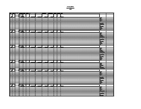
Artifact catalogue containing records from the Lovstrom survey 1985.
Scope and Content
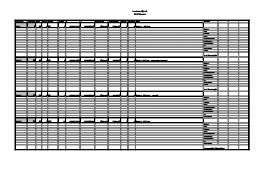
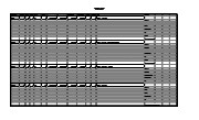
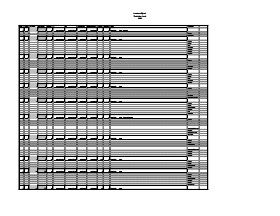
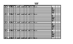
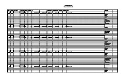
Spreadsheet containing information about the artifacts recovered, including: unit, level, artifact number, catalogue number, depth, co-ordinates, entry date, date recovered,count, weight, UTM co-ordinates, notes(excavators initials and comments) and artifact identification.
Block A was the most southern site in the locale. The excavation block consisted of 12 contiguous 1m2 units dug in a 3m x 4m rectangle. The block was the least productive of cultural materials, and bone preservation was the poorest. Under the sod, the black loam layer appeared at 5 cm below surface, and the glacial clay at 25 cm below surface. Excavators described the soil matrix as gritty and silty, and it became concrete hard when dried.
The occupation or bone layer extended from 10 to 25 cm below surface and consisted of a contiguous scatter of FCR and unidentifiable large ungulate bone which was heavily processed and intensively scavenged by carnivores. Most cultural materials were recovered within this layer. Fire cracked rock (FCR) and small burnt bone fragments were present but no intact hearths or processing features were evident.
Non-cultural materials included limestone and other natural pebbles derived from the parent till. (These small limestone pebbles were apparent in the occupation layers in other blocks as well). Root and rodent disturbance was extensive throughout Block A. Most units were excavated to gravelly clay till. Nine of the twelve units were dug to level 4b, which ended at 40 cm b.s.
No further excavations were done at this site. No C14 dates were taken.
Scope and Content
Sub-sub-sub series contains: Summary information of field methology, number and co-ordinates of excavations, personnel and their staff position; Field journals are daily records of recoveries, features and activities at the site; Site records include excavation level and unit summaries, feature sheets, profiles; sample records and maps; Artifact catalogues are lists and identifications of all artifacts recovered; Photographs are of excavation units, features, the landscape and personnel.
Field journals have been scanned in multi-page PDF files. Artifact catalogues are PDF files in spreadsheet format. Photographs are in jpeg format.
History / Biographical
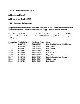
Large scale excavations of five block sites took place in 1987 under the direction of Bev Nicholson with Jane Gibson as crew chief. Block A consisted of 12 excavation units.
Scope and Content
Sub-sub-sub series contains: Summary information of field methology, number and co-ordinates of excavations, personnel and their staff position.
Artifact catalogue containing records from the excavation units 25-27; 30-35; 38-40 at Lovstrom Block A.
Scope and Content
Spreadsheet containing information about the artifacts recovered, including: unit, level, artifact number, catalogue number, depth, co-ordinates, entry date, date recovered,count, weight, UTM co-ordinates, notes(excavators initials and comments) and artifact identification.
Artifact catalogue containing records from the Lovstrom test units 1985.
Scope and Content
Spreadsheet containing information about the artifacts recovered, including: unit, level, artifact number, catalogue number, depth, co-ordinates, entry date, date recovered,count, weight, UTM co-ordinates, notes(excavators initials and comments) and artifact identification.
Artifact catalogue containing records from the excavation units 45 to 55 at Lovstrom Block B.
Scope and Content
Spreadsheet containing information about the artifacts recovered, including: unit, level, artifact number, catalogue number, depth, co-ordinates, entry date, date recovered,count, weight, UTM co-ordinates, notes(excavators initials and comments) and artifact identification.
Artifact catalogue containing records from the excavation units 56 to 65 at Lovstrom Block B.
Scope and Content
Spreadsheet containing information about the artifacts recovered, including: unit, level, artifact number, catalogue number, depth, co-ordinates, entry date, date recovered,count, weight, UTM co-ordinates, notes(excavators initials and comments) and artifact identification.
Block C was situated in sparse oak forest with an understory of saskatoon, hazelnut and a thick ground cover of poison ivy and sarsaparilla. The block measured 3m and 3m and contained nine excavation units. All units were excavated to 35cm below surface. The soil horizons were much like the other blocks, except for a rusty brown stain in the first level, giving the upper black loam a mottled appearance. The brown patches were clay mixed with loam and were harder than the surrounding matrix. No definitive interpretation of these phenomena was attempted but this effect may be the result of natural brush or forest fires. Under the 5cm so d/humus (Ah) layer, the loam horizon extended approximately 5cm – 25 cm below surface, and averaged 20 cm thick. Bone was concentrated within this horizon between 10 cm – 20 cm below surface.
Block C was notable for its concentrations of articulated bison bone. Most noteworthy was an articulated unit composed of lumbar vertebrae, pelvis, and sacrum. Several thoracic vertebra/proximal rib end concentrations were also recovered. There were more vertebrae and rib sections recovered in the units in proportion to other bones. A few sherds, some debitage and a single Prairie Side-Notched point fragment were among the recoveries. Based on the quantity of bone, the density of the bone layer, and the articulated butchering units the area has been interpreted as a bone midden.
Faunal material was analysed by Jessica MacKenzie for her Honours Thesis: "A reconstruction of butchering processes in Block C from the Lovstrom site DjLx-1 in Southwestern Manitoba."
Radiocarbon date: 850/115BP XU 79.
Scope and Content
Sub-sub-sub series contains: Summary information of field methology, number and co-ordinates of excavations, personnel and their staff position; Field journals are daily records of recoveries, features and activities at the site; Site records include excavation level and unit summaries, feature sheets, profiles; sample records and maps; Artifact catalogues are lists and identifications of all artifacts recovered; Photographs are of excavation units, features, the landscape and personnel.
Field journals have been scanned in multi-page PDF files. Artifact catalogues are PDF files in spreadsheet format. Photographs are in jpeg format.
History / Biographical
Large scale excavations of five block sites took place in 1987 under the direction of Bev Nicholson with Jane Gibson as crew chief. Block C consisted of nine excavation units. Miggs Green was Block C assistant.
Scope and Content
Sub-sub-sub series contains: Summary information of field methology, number and co-ordinates of excavations, personnel and their staff position.
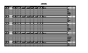
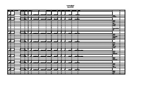
Artifact catalogue containing records from the excavation units 71-73; 77-81 at Lovstrom Block C. The catalogue contains 1095 records.
Scope and Content
Spreadsheet containing information about the artifacts recovered, including: unit, level, artifact number, catalogue number, depth, co-ordinates, entry date, date recovered,count, weight, UTM co-ordinates, notes(excavators initials and comments) and artifact identification.
Block D was wooded with oak and an understory of saskatoon and hazelnut with a thick ground cover of poison ivy and sarsaparilla. Root and rodent disturbance was extensive.
Based on the recoveries from Test Unit 22 during the survey, further excavations were carried out. Two units 87 and 93 were excavated in 1987. A further four units were excavated in 1988. There appears to be a pre contact occupation and a protohistoric feature within the block.
Diagnostic lithics included a chert Plains Side-notch projectile point, and a large Woodland side-notched point. The lithic materials from Block D are primarily local cherts followed in abundance by Knife River Flint and Tongue River Silicified Sediment – both of which are exotics imported from the southwest. Faunal remains were primarily bison.
Thin-walled obliterated fabric impressed pottery with grit temper was recovered in all units. Diagnostic ceramics included two rims, one with a fabric impressed exterior and the lip notched with dowel impressions, and a second thick walled rim was fabric impressed to the lip. The ceramic wares appear to be essentially a Woodland complex with overtones of Plains influence.
RC date: 230/90 BP.
Scope and Content
Sub-series has been divided into sub sub series including: Lovstrom Block D 1987 and Lovstrom Block D 1988.
Field journals have been scanned in multi-page PDF files. Artifact catalogues are PDF files in spreadsheet format. Photographs are in jpeg format.
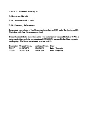
History / Biographical
Large scale excavations of five block sites took place in 1987 under the direction of Bev Nicholson with Jane Gibson as crew chief. Block D consisted of 2 excavation units.
Scope and Content
Sub-sub-sub series contains: Summary information of field methology, number and co-ordinates of excavations, personnel and their staff position.
Artifact catalogue containing records from the excavation units 87 and 93 at Lovstrom Block D. The catalogue contains 27 records.
Scope and Content
Spreadsheet containing information about the artifacts recovered, including: unit, level, artifact number, catalogue number, depth, co-ordinates, entry date, date recovered,count, weight, UTM co-ordinates, notes(excavators initials and comments) and artifact identification.
Field journals have been scanned in multi-page PDF files. Artifact catalogues are PDF files in spreadsheet format. Photographs are in jpeg format.
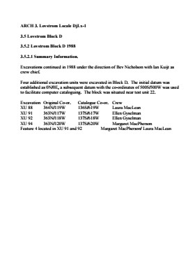
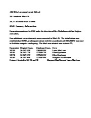
History / Biographical
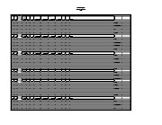
Large scale excavations of five block sites took place in 1988 under the direction of Bev Nicholson with Ian Kuijit as crew chief. Four excavation units were added to Block D.
Scope and Content
Sub-sub-sub series contains: Summary information of field methology, number and co-ordinates of excavations, personnel and their staff position.
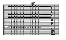
Artifact catalogue containing records from the excavation units 88, 91, 92, and 94 at Lovstrom Block D. The catalogue contains 719 records.
Scope and Content
Spreadsheet containing information about the artifacts recovered, including: unit, level, artifact number, catalogue number, depth, co-ordinates, entry date, date recovered,count, weight, UTM co-ordinates, notes(excavators initials and comments) and artifact identification.
This site is situated in a naturally sheltered area with a low rise to the east and south partly encircling a flat area open to the west. Present natural vegetation is an open oak forest with a light understory of saskatoon, hazelnut, poison ivy and sarsaparilla. It is situated on the till plain at the upper end of a ravine leading to Jock’s Creek.
Two test units six meters apart were excavated in 1987 and produced cultural materials which warranted a block excavation, so seven contiguous 1m2 units were then opened. These units proved to be very productive of cultural remains. Subsequent excavations in 1988 increased the number of excavated units to 21. In 1991 a further eight units were excavated for a total of 29 excavations and two test units. Excavations went deeper in this block than in Blocks C or B. Remains from the block included bison bone, bone tools, fire-cracked rock, ceramics, lithics including tools and debitage and a hearth. Another occupation was recovered in 1991 containing a hearth and living floor.
Radiocarbon samples have produced two distinct sets of radiocarbon dates from 1987 and 1988 excavations. There appears to be two or possibly three cultural horizons definable within this block.
An upper cultural horizon, located between 14-21 cm below surface, contains large bison bone and fire-cracked rock dating to 465/100B.P from XU 128.
A lower horizon in the 20-25 cm level contained FCR, bison bone and lithic scatter that was dated to 675/70 B.P. from XU 122 and 715/110 from XU 114.
Scope and Content
Sub-series has been divided into sub sub series including: Lovstrom Block E 1987, Lovstrom Block E 1988 and Lovstrom Block E 1991.