Field journals have been scanned in multi-page PDF files.
History / Biographical
The Crepeele site was identified from the results of the Casselman survey and excavated in 2003, 2004, 2005 and 2007.
In 2008 a small crew under the direction of Bev Nicholson returned to the site to gather further samples and verify profiles. Three units (XU 50, 51 and 52) were excavated. As well the Graham site 2008 was also excavated.
The field journals contain information about both the Crepeele and Graham sites 2008.
Scope and Content
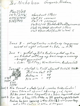
Record of daily observations at the site including: excavation methods, items recovered, features, local environment and weather.
Field journals have been scanned in multi-page PDF files.
History / Biographical
The Crepeele site was identified from the results of the Casselman survey and excavated in 2003, 2004, 2005 and 2007.
In 2008 a small crew under the direction of Bev Nicholson returned to the site to gather further samples and verify profiles. Three units (XU 50, 51 and 52) were excavated. As well the Graham site 2008 was also excavated.
The field journals contain information about both the Crepeele and Graham sites 2008.
Scope and Content
Record of daily observations at the site including: excavation methods, items recovered, features, local environment and weather.
Field journals have been scanned in multi-page PDF files. Artifact catalogues are PDF files in spreadsheet format. Photographs are in jpeg format.
History / Biographical
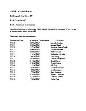
In 2007 the Brandon University Field School was held at both the Crepeele site in the Crepeele locale. Denise Ens instructed the school with Jessica McKenzie and Kate Decter as teaching assistants.
Seventeen units were excavated (XU3 - 46). Faunal (animal bone), lithics, fire cracked rock, diagnostic lithics and ceramics were recovered from the site.
Scope and Content
Sub-sub-sub series contains: Summary information of field methology, number and co-ordinates of excavations, personnel and their staff position.
Field journals have been scanned in multi-page PDF files. Artifact catalogues are PDF files in spreadsheet format. Photographs are in jpeg format.
History / Biographical
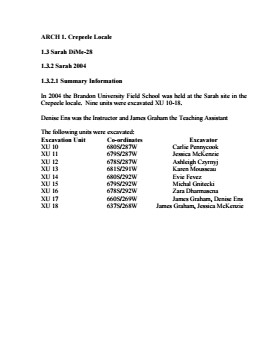
The Sarah site was initially chosen for excavation based on the results of the Casselman survey. The survey recovered significant amounts of faunal remains, some ceramics and lithics from the test pits. Excavations took place in 2003 at the Sarah site DiMe-28.
In 2004 further excavation took place as part of a Brandon University Archaeology Field School. Units 10 to 18 were excavated with Denise Ens as the instructor and James Graham teaching assistant.
Scope and Content
Sub-sub-sub series contains: Summary information of field methology, number and co-ordinates of excavations, personnel and their staff position.
Field journals have been scanned in multi-page PDF files.
History / Biographical
The Sarah site was chosen for excavation based on the results of the Casselman survey. The survey recovered significant amounts of faunal remains, some ceramics and lithics from the test pits. Excavations took place in 2003 at Crepeele West (Units 1-5) and Crepeele East (Units 6-9). The site was subsequently renamed the Sarah site DiMe-28.
Field journals from 2003 contain notes concerning the Casselman survey, Crepeele and Sarah site.
Scope and Content
Record of daily observations at the site including: excavation methods, items recovered, features, local environment and weather.
Radiocarbon date reports have been scanned in multi-page PDF files.
History / Biographical
The Crepeele locale is located within the larger Lauder Sandhills area, located in southwestern Manitoba. The area is a complex region of high biodiversity made up of stabilized sand dunes and wetlands that encourage the development of mixed forest and grass prairie. This area provided a variety of subsistence resources for pre-European hunter-gatherers. At the present time the grass prairie is now farm land but the areas of vegetated sand dunes have not been cultivated and have revealed numerous pre-contact archaeological sites.
Archaeological surveying was conducted in 2003. The results of the 2003 Casselman survey showed over 300 test uints contained cultural material and indicated several areas for further examination including the Crepeele site DiMe-29, Sarah site DiMe-28 and Graham sites DiMe-30.
From 2003 to 2008 field work took place at the locale with 75 - 1m x1m units excavated. The Crepeele locale is a complex region of high biodiversity made up of stabilized sand dunes and wetlands that encourage the development of mixed forest and grass prairie. This area provided a variety of subsistence resources for pre-European hunter-gatherers. At the present time the grass prairie is now farm land but the areas of vegetated sand dunes have not been cultivated and have revealed numerous pre-contact archaeological sites.
To help establish the cultural sequence at the locale Radiocarbon dates were obtained from the three sites in the Crepeele locale.
Radiocarbon dating
The technique of radiocarbon dating was developed by Willard Libby and his colleagues at the University of Chicago in 1949.
Radiocarbon dating is used to estimate the age of organic remains from archaeological sites. Organic matter has a radioactive form of carbon (C14) that begins to decay upon death. C14 decays at a steady, known rate of a half life of 5,730 years. The technique is useful for material up to 50,000 years. Fluctuations of C14 in the atmosphere can affect results so dates are calibrated against dendrochronology. Radiocarbon dates are calibrated to calendar years.
Dates are reported in radiocarbon years or Before Present. Before Present refers to dates before 1950. The introduction of massive amounts of C14, due to atomic bomb and surface testing of atomic weapons, has widely increased the standard deviation on all dates after A.D. 1700 causing these dates to be unreliable.
Accelerated mass spectrometry can more accurately measure C14 with smaller samples and can date materials to 80,000 years.
Scope and Content
Sub sub series contains radiocarbon dates from: Crepeele, Sarah and Graham sites.
Field journals have been scanned in multi-page PDF files. Artifact catalogues are PDF files in spreadsheet format. Photographs are in jpeg format.
History / Biographical
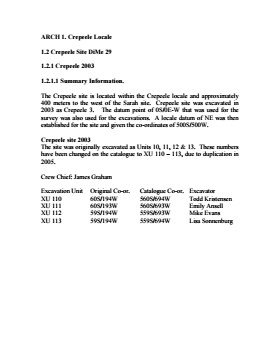
The Crepeele site was identified from the results of the Casselman survey. The site is located within the Crepeele locale approximately 400 meters to the west of the Sarah site. The units were excavated by Crew Chief James Graham and the crew from the survey.
The Crepeele site was excavated in 2003 as Crepeele 3 with the units numbered as units 10, 11, 12 & 13. These numbers have been changed on the catalogue to XU 110 – 113, due to duplication in 2005. Corresponding documents have been changed but there may be some reference to the initial numbers in the field journals.
The artifacts recovered from these four excavations are faunal (animal bone), mainly bison, lithic materials (stone tools and flakes) and some ceramic (pottery). The artifact catalogue has over 600 records.
Scope and Content
Sub-sub-sub series contains: Summary information of field methology, number and co-ordinates of excavations, personnel and their staff position; Field journalsare daily records of recoveries, features and activities at the site; Site records include excavation level and unit summaries, feature sheets, profiles; sample records and maps; Artifact catalogues are lists and identifications of all artifacts recovered; Photographs are of excavation units, features, the landscape and personnel.
The high biodiversity and evidence of pre-Europeon contact prompted the decision to test the Crepeele locale. The survey was named in recognition of the Casselman family, the original landowners.
Archaeological testing began in the Crepeele locale in May 2003 on property now owned by the Crepeele family. The locale covers over 6 sections or approximately 3,800 acres of land in an area of stabilized sand dunes and wetlands covered with mixed forest and prairie grass. Given the terrain, the size of the crew and time constrains, an area of approximately 60 acres was chosen for the survey. The survey used the established archaeological methodology of walking the selected area and using a shovel test surveyed grid. The use of GIS technology to locate the exact test spot and record the information into a GIS database was a significant advance and was one of the advantages of the integration of multi-disciplinary techniques encouraged by the SCAPE project. Over one half of the test pits resulted in the recovery of cultural materials. The results of the Casselman survey indicated several areas for further examination including areas that became the Crepeele, Sarah and Graham sites.
Scope and Content
Sub sub series has been divided into five sub sub sub series including: (1) Summary information; (2) Field journals; (3) Site records; (4) Artifact catalogues; and (5) Photographs.
The Lovstrom surface collection came from small fields cleared within, and adjacent to, the major portions of the site which were excavated. The Lovstroms initial collection has since been added to by field personnel from Brandon University. The initial collections consisted of lithics and ceramics. A collection of faunal remains from the cultivated area was made by a Brandon University zooarchaeology class in 1986 which yielded specimens of elk, canid, mussels, and sucker, in addition to an expected abundance of bison. Since these materials were in a surface context, it may be that some of the faunal remains were historic.
The high biodiversity and evidence of pre-Europeon contact prompted the decision to test the Lovstrom locale. Nine 1m2 units were excavated in 1985 and, in 1986, an additional 15 1m2 units were excavated for a total of 24 test units. This testing indicated the presence of a large precontact locale with lithics, woodland ceramics and large amounts of reasonably well-preserved faunal materials.
The lithics indicated a late Prehistoric occupation (Nicholson 1986:35). However, the ceramics were more useful in that they identified the presence of Late Woodland cultures (Blackduck and Duckbay) and a single Middle Missouri vessel. It is believed that the Middle Missouri vessel was imported since the paste and construction/decorative technology differ distinctively from that of all other vessels recovered from the site. It was on the basis of an examination of these surface finds that the decision to test the Lovstrom site was made. These test excavations were conducted during the summers of 1985 and 1986.
Field investigations through shovel tests, excavation units, and examination of rodent mounds, indicated that the cultural deposits at the Lovstrom locale extend approximately 500m north from the edge of the Souris channel and eastward for over two hundred meters from the escarpment along Jock’s Creek. The presence of dense forest vegetation covering much of the locale, and the subsurface nature of the archaeological deposits obscured surface indications.
Radiocarbon dates: Test Unit 4: 1215/320 BP and Test Unit 8 1280/190 BP
Scope and Content
Sub-series has been divided into sub sub series including: Lovstrom survey 1985 and Lovstrom survey 1986
Block A was the most southern site in the locale. The excavation block consisted of 12 contiguous 1m2 units dug in a 3m x 4m rectangle. The block was the least productive of cultural materials, and bone preservation was the poorest. Under the sod, the black loam layer appeared at 5 cm below surface, and the glacial clay at 25 cm below surface. Excavators described the soil matrix as gritty and silty, and it became concrete hard when dried.
The occupation or bone layer extended from 10 to 25 cm below surface and consisted of a contiguous scatter of FCR and unidentifiable large ungulate bone which was heavily processed and intensively scavenged by carnivores. Most cultural materials were recovered within this layer. Fire cracked rock (FCR) and small burnt bone fragments were present but no intact hearths or processing features were evident.
Non-cultural materials included limestone and other natural pebbles derived from the parent till. (These small limestone pebbles were apparent in the occupation layers in other blocks as well). Root and rodent disturbance was extensive throughout Block A. Most units were excavated to gravelly clay till. Nine of the twelve units were dug to level 4b, which ended at 40 cm b.s.
No further excavations were done at this site. No C14 dates were taken.
Scope and Content
Sub-sub-sub series contains: Summary information of field methology, number and co-ordinates of excavations, personnel and their staff position; Field journals are daily records of recoveries, features and activities at the site; Site records include excavation level and unit summaries, feature sheets, profiles; sample records and maps; Artifact catalogues are lists and identifications of all artifacts recovered; Photographs are of excavation units, features, the landscape and personnel.
Field journals have been scanned in multi-page PDF files. Artifact catalogues are PDF files in spreadsheet format. Photographs are in jpeg format.
History / Biographical
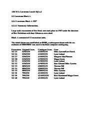
Large scale excavations of five block sites took place in 1987 under the direction of Bev Nicholson with Jane Gibson as crew chief. Block A consisted of 12 excavation units.
Scope and Content
Sub-sub-sub series contains: Summary information of field methology, number and co-ordinates of excavations, personnel and their staff position.
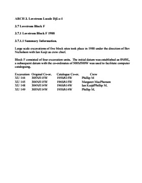
In 1988 four 1m2 units were excavated in this Block F. The forest cover is identical to that of Block E, with an open oak forest with a light understory of saskatoon, hazelnut, poison ivy and sarsaparilla.
Underneath the litter mat (Ah) is a shallow, 15-20 cm “A” horizon of dark grey/brown silty loam with a high representation of pebble size clasts. The glacial clays, encountered at 20 cm below surface, consist of a matrix of light tan sandy clays containing rounded pebble to cobble size rocks.
The recoveries from this block consisted of a few ceramics, including Vickers Focus rim sherds, four lithic tools and a number of small bison bone fragments. There was no discernible cultural stratigraphy in the four 1m2 units and the limited deposits of bone, ceramics and lithics were dispersed randomly throughout the 25 cm of cultural matrix. The lithic materials frequencies were similar to those in Block E with local cherts and KRF being the most abundant categories. A small amount of fire-cracked rock and a few large identifiable bison bones were recovered – all distributed randomly with little evidence for any pattern of clustering.
No RC dates.
Scope and Content
Sub-sub-sub series contains: Summary information of field methology, number and co-ordinates of excavations, personnel and their staff position; Field journals are daily records of recoveries, features and activities at the site; Site records include excavation level and unit summaries, feature sheets, profiles; sample records and maps; Artifact catalogues are lists and identifications of all artifacts recovered; Photographs are of excavation units, features, the landscape and personnel.
Field journals have been scanned in multi-page PDF files. Artifact catalogues are PDF files in spreadsheet format. Photographs are in jpeg format.
History / Biographical
Large scale excavations of four block sites took place in 1988 under the direction of Bev Nicholson with Ian Kuijt as crew chief. Block F consisted of 4 excavation units.
Scope and Content
Sub-sub-sub series contains: Summary information of field methology, number and co-ordinates of excavations, personnel and their staff position.
In 1988 four units were excavated in Block G. The vegetation is similar to other areas in the locale with an open oak forest with a light understory of saskatoon, hazelnut, poison ivy and sarsaparilla.
Excavations recovered artifacts between 0 cm – 15 cm b.s. The cultural deposits are very shallow and it is quite possible that what appears to be a single occupation may in fact represent multiple occupation compressed deposits as a result of deflation or the lack of sedimentation in this raised area. This latter view is supported by the ceramics which appear to be a mixture of Blackduck and Vickers Focus wares.
The frequency and distribution of cultural material from block G contrasts with that of other sites in the locale. While the diagnostic materials are similar, the nature of the background debris and the associated lithic assemblage suggests that this area was utilized for a different set of activities.
Unlike Blocks E and H, there is very little in the way of ceramics, fire-cracked rock or bison bone, yet a significant amount of lithic debitage and six Plains/Prairie Side-notched projectile points were recovered. No unifaces or scrapers were recovered. This may be an area where activities such as manufacture and hafting of projectile points; hunting activities, butchering and refuse disposal took place.
No RC dates were taken.
Scope and Content
Sub-sub-sub series contains: Summary information of field methology, number and co-ordinates of excavations, personnel and their staff position; Field journals are daily records of recoveries, features and activities at the site; Site records include excavation level and unit summaries, feature sheets, profiles; sample records and maps; Artifact catalogues are lists and identifications of all artifacts recovered; Photographs are of excavation units, features, the landscape and personnel.
Field journals have been scanned in multi-page PDF files. Artifact catalogues are PDF files in spreadsheet format. Photographs are in jpeg format.
History / Biographical
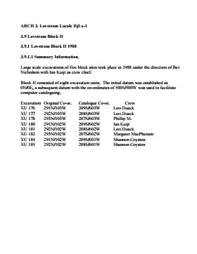
Large scale excavations of four block sites took place in 1988 under the direction of Bev Nicholson with Ian Kuijt as crew chief. Block G consisted of 4 excavation units.
Scope and Content
Sub-sub-sub series contains: Summary information of field methology, number and co-ordinates of excavations, personnel and their staff position.
The vegetation in block H is similar to other areas in the locale with an open oak forest with a light understory of saskatoon, hazelnut, poison ivy and sarsaparilla.
The excavations of the eight 1m2 units in 1988 resulted in the recovery of over 650 ceramic fragments including 20 rim sherds from at least four vessels, a grooved maul, fire-cracked rock, lithic debitage and a reworked Avonlea projectile point. A large amount of bison bone, including a number of axial elements and a fragmented skull were also recovered.
Based on the 1988 recoveries at the site further excavations took place in 1991. Nine excavation units were opened next to the previous excavations. Another 250 ceramic sherds were recovered in 1991. Nine vessels have been identified based on rim sherds. Vickers Focus and Woodland vessels have been identified and two vessels similar to Scattered Village Complex were recovered.
The lithic material assemblage is intermediate between Blocks G and E with KRF being the most frequent material category followed by local cherts.
Two features, a hearth and a curvilinear arrangement of rock were recovered. The high numbers of ceramic fragments suggests a habitation area, rather than hunting or butchering behavior. However, the separation of occupations at the site is difficult to establish and there may be different uses of the site by successive occupations.
Radiocarbon dates from this block indicate two occupations separated in time by some 300 years. XU 181 – 405/110 BP and XU 184 – 780/110 BP.
Scope and Content
Sub-series has been divided into sub sub series including: Lovstrom Block H 1988 and Lovstrom Block H 1991.
Field journals have been scanned in multi-page PDF files. Artifact catalogues are PDF files in spreadsheet format. Photographs are in jpeg format.
History / Biographical
Large scale excavations of four block sites took place in 1988 under the direction of Bev Nicholson with Ian Kuijt as crew chief. Block H consisted of eight excavation units.
Scope and Content
Sub-sub-sub series contains: Summary information of field methology, number and co-ordinates of excavations, personnel and their staff position.
Field journals have been scanned in multi-page PDF files. Artifact catalogues are PDF files in spreadsheet format. Photographs are in jpeg format.
History / Biographical
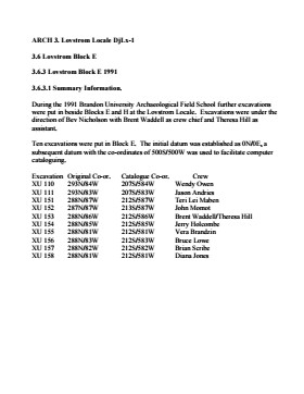
Large scale excavations of two block sites took place in 1988 under the direction of Bev Nicholson with Brett Waddell as crew chief and Theresa Hill as assistant. Block E consisted of 10 additional excavation units.
Scope and Content
Sub-sub-sub series contains: Summary information of field methology, number and co-ordinates of excavations, personnel and their staff position.
Field journals have been scanned in multi-page PDF files. Artifact catalogues are PDF files in spreadsheet format. Photographs are in jpeg format.
History / Biographical
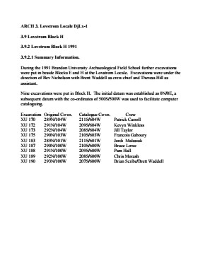
Large scale excavations of two block sites took place in 1988 under the direction of Bev Nicholson with Brett Waddell as crew chief and Theresa Hill as assistant. Block H consisted of nine additional excavation units.
Scope and Content
Sub-sub-sub series contains: Summary information of field methology, number and co-ordinates of excavations, personnel and their staff position.
Block C was situated in sparse oak forest with an understory of saskatoon, hazelnut and a thick ground cover of poison ivy and sarsaparilla. The block measured 3m and 3m and contained nine excavation units. All units were excavated to 35cm below surface. The soil horizons were much like the other blocks, except for a rusty brown stain in the first level, giving the upper black loam a mottled appearance. The brown patches were clay mixed with loam and were harder than the surrounding matrix. No definitive interpretation of these phenomena was attempted but this effect may be the result of natural brush or forest fires. Under the 5cm so d/humus (Ah) layer, the loam horizon extended approximately 5cm – 25 cm below surface, and averaged 20 cm thick. Bone was concentrated within this horizon between 10 cm – 20 cm below surface.
Block C was notable for its concentrations of articulated bison bone. Most noteworthy was an articulated unit composed of lumbar vertebrae, pelvis, and sacrum. Several thoracic vertebra/proximal rib end concentrations were also recovered. There were more vertebrae and rib sections recovered in the units in proportion to other bones. A few sherds, some debitage and a single Prairie Side-Notched point fragment were among the recoveries. Based on the quantity of bone, the density of the bone layer, and the articulated butchering units the area has been interpreted as a bone midden.
Faunal material was analysed by Jessica MacKenzie for her Honours Thesis: "A reconstruction of butchering processes in Block C from the Lovstrom site DjLx-1 in Southwestern Manitoba."
Radiocarbon date: 850/115BP XU 79.
Scope and Content
Sub-sub-sub series contains: Summary information of field methology, number and co-ordinates of excavations, personnel and their staff position; Field journals are daily records of recoveries, features and activities at the site; Site records include excavation level and unit summaries, feature sheets, profiles; sample records and maps; Artifact catalogues are lists and identifications of all artifacts recovered; Photographs are of excavation units, features, the landscape and personnel.