Photograph is scratched and has been glued to a backing board that has warped over time
Scope and Content
Photograph shows street view of the northeast intersection of the 000 block of 8th Street and Rosser Avenue. Horse and buggies are parked along the east side of 8th Street. Businesses on the east side of 8th Street from Pacific to Rosser Avenues are clearly visible and include: a Lunch Room (likely Aagaard's Lunch Counter), the Hotel Imperial Annex, Liverpool House (a boarding house), R.S. Thompson and Company Real Estate Office (Land Office), a barber shop (likely J. Coulter's), Frank Gowen photography studio, and Fleming's Drug Store. A possible street fair is in progress on Rosser Avenue. One man is standing on a soap box and is surrounded by a crowd in the middle of 8th Street. Another man can be seen standing behind a booth on the northwest street corner. Building construction appears to be happening on the west corner of 8th Street and Rosser Avenue.
Notes
Writing on the front of the photograph matting reads: 297. One photograph (20-2009.80) is glued below the photograph. Another photograph is glued on the reverse side. Page appears to be from a photo album.
Photographs have been glued to a backing board that has warped over time
History / Biographical
Photograph of possible Dakota from Sioux Valley in Brandon for the summer fair.
Scope and Content
Photograph shows street view of north side of Rosser Avenue, primarily the 700 block. Businesses visible in the Beaubier Block include the Empire Hotel. Businesses east of the Empire Hotel are grocer A.M. Percival, the Brandon Hardware Company, and the Arlington Hotel. A number of Aboriginal peoples are driving horse and buggies east along Rosser Avenue as large numbers of spectators look on.
Notes
Writing on the front of the photograph matting reads: 298. One photograph (20-2009.79) is glued above, another (20-2009.81) adjacent. One other is glued on the reverse side. Page appears to be from a photo album.
Left hand corner of mat is bent. Mock-up instructions are written in pencil at the bottom right hand corner. Portions of the photograph itself are marked with pen.
History / Biographical
The Queen's Hotel was located on the corner of Rosser Avenue and Tenth Street (Steen & Boyce, 1882. Brandon, Manitoba, Canada and Her Industries. Steen & Boyce Publishers Printers & Binders, 81.). Therefore this photo appears to display Rosser Avenue looking east. P.E. 11/06/09
Scope and Content
Photograph shows early Rosser Avenue under construction between 9th Street and 10th Street in the 1880s. Buildings that line the avenue are wood framed and there are wooden boardwalks in front of a few structures. On the north side of Rosser Avenue signs for Fortier & Bucke Commision Agents and Transit House (Hotel) can be seen. On the south side of Rosser Avenue, the Queen's Hotel and Robinson Brothers and Company groceries and dry goods store are open for business. A family appears to be standing on the stoop at the dry goods store. A boy is lounging in the entryway of the Queen's Hotel. A man is standing on a wooden plank that extends across the dirt road of Rosser Avenue between the dry goods store and the commission agents' shop.
Postcard shows the 100 block of 10th Street facing north. The CPR train station can be seen at the end of 10th Street. The sign for the Rex Cafe is visible on the west side of 10th Street. On the east side of 10th Street, billboards for Campbell & Campbell furniture are visible as well as signs for Pianos and the Orpheum Theatre. Motorists and cyclists share the road. Street car tracks run the length of 10th Street.
Notes
Back of postcard reads: Morning reflection of Brandon's skyline on the Assiniboine River, photo by Sandy Black, printed in Brandno, Manitoba, Canada by Leech Printing Ltd.
Photograph mat is bent. Emulsion problems with image.
Scope and Content
Photograph shows Rosser Avenue in its incipient stages. Canvas tents are mixed amongst wooden structures. The James Smart Hardware store, Winter & O'Neail Groceries & Provisions, and the law office of F.G.A. Henderson in the Molesworth Block can be seen on the north side of Rosser Avenue. A street sign designating 6th Street can be seen below the Winter & O'Neail sign. A horse and buggie is traveling down the dirt track that is Rosser Avenue. Groups of men can be seen congregating outside some of the local businesses.
Notes
Front of photograph reads: Rosser Avenue, Brandon 1882-1883, from east of Six Street. Back of photograph is stamped: I. Bennetto & Co., Photographers, Opposite Post-Office, Winnipeg, Man.
Corners of photograph mat are bent. Picture is cracked.
Scope and Content
Photograph shows an early view of Brandon's 6th Street in the 1880s. The Winter & O'Neail Groceries & Provisions and James Smart Hardware storefronts have been photographed. A street sign designating 6th Street can be seen below the Winter & O'Neail sign. A horse and cart is parked in front of the grocery store. A number of men wearing hats and jackets are standing along the boardwalk while posing for the picture. Lumber/timber saws are displayed in teh windows of the hardware store.
Notes
Front of photograph reads: 6th Street, Brandon, Manitoba, 1881-1882, Entrance [to Winter & O'Neail] corner of Rosser Ave & 6th Street.
Photograph shows the 800 block of Rosser Avenue facing west. On the south side of Rosser Avenue the Nation Block, Christie's Bookstore, and Reesor's Clock can be seen. A number of horse and buggies/carriages are travelling along Rosser Avenue.
Photograph shows the Brandon Wheat Market along Pacific Avenue on November 30, 1885. Farmers can be seen driving wagon teams loaded with bags of grain in line on Pacific Avenue from 10 Street to at least 7th Street. On the north side of Pacific Avenue the CPR Land Office and grain elevators are pictured. On the south side of Pacific Avenue, the general merchant/hardware store Bower, Blackburn, Mundell & Porter is situated on the corner of Pacific Avenue and 10th Street. A 10th Street sign is affixed to the merchants' store. On the east side of the general store, Edie House, the Grand View Hotel, and a Farmers' boarding and lodging house can be seen. Most of the buildings appear to be woodframed except for the Grand View, which is constructed of brick. Sidewalks appear to be in place on the south side of Pacific and snow dusts the streets. A baby swathed in winter clothing sits in a pram/baby carriage in front of the general store.
Notes
Writing on the front of the photograph reads: Novemeber 30th, 1885, Brandon Wheat Market
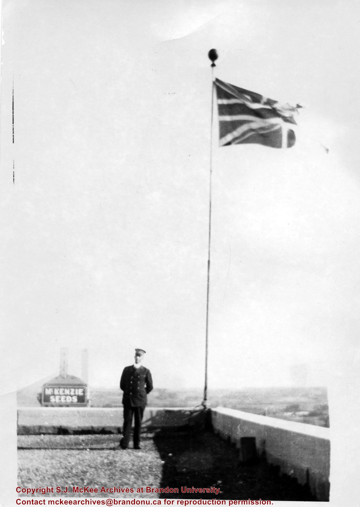
Photograph shows a view from the rooftop of the Prince Edward Hotel. The south side of the Brandon Hotel (most recently the Brandon Inn) and a service station along Prince Avenue can be seen.
Notes
Writing on the back of photograph reads: across the street from roof of P.E. Hotel 1927
Postcard is of a combine bailing hay in the north end of Brandon at the junction of First Street and Veterans' Way. The Brandon city skyline is in the background and the orange Pioneer Grain elevator can be seen on the left side of the postcard.
Notes
Writing on the front of the postcard reads: Brandon, The Wheat City. Back of the postcard reads: Brandon the Agricultural and Industrial center for southwestern Manitoba; Photo by Sandy Black; Printed in Brandon, Manitoba, Canada, by Leech Printing Ltd.
Photograph shows a street view of 10th Street facing north. There are many automobiles parked along the street and several pedestrians in summer dress are on the sidewalks and street. Visible business signs include: Hentzman & Co. Pianos (possibly belonging to J.J.H. McLean Co. Ltd.), the Strand Theatre, T & D Clothes, Campbell & Campbell, the CPR Station, and Bowling Alley and Billiards.
Notes
Part of "Souvenir of Brandon, Manitoba, Canada [viewbook], Printed by Photogelatine Engraving Co. Limited, Ottawa." Dates obtained from the Burchill's Music Store Henderson's Brandon City Directory listings (1927-1929). Writing on the front of the photograph reads: 10th St., looking north (C.P.R. Station at end of Street) Brandon, Man.
Photograph shows the 700-block of Rosser Avenue facing west. Visible businesses on the north side of Rosser Avenue include: Burchill's Music Store, E.W. Woolworth Co. Ltd. 5-10 and 15 Cent Store in the E.E. Evans Block, Empire Hotel, and W.A. Paterson Drugs. Automobiles are parked on both sides of the avenue and at the time the photograph was taken, Rosser Avenue was a two-way street.
Notes
Part of "Souvenir of Brandon, Manitoba, Canada [viewbook], Printed by Photogelatine Engraving Co. Limited, Ottawa." Dates obtained from the Burchill's Music Store Henderson's Brandon City Directory listings (1927-1929). Writing on the front of the photograph reads: Rosser St. [sic.] - Brandon, Man.
Photograph shows the CPR Train Station on Pacific Avenue and 10th Street.
Notes
Part of "Souvenir of Brandon, Manitoba, Canada [viewbook], Printed by Photogelatine Engraving Co. Limited, Ottawa." Dates obtained from the Burchill's Music Store Henderson's Brandon City Directory listings (1927-1929). Writing on the front of the photograph reads: CPR Station, Brandon, Man.
Photograph shows a panorama, bird's-eye-view of downtown Brandon, between Pacific and Rosser Avenues and 7th Street facing east. Photoraph likely taken from the McKenzie Seeds Building. Visible businesses include: Western Canada Flour Mills, Hanbury Hardware Co. Ltd., Cockshutt Plow Co., New Pacific Hotel, Gordon McKay Building, and Arlington Hotel.
Notes
Part of "Souvenir of Brandon, Manitoba, Canada [viewbook], Printed by Photogelatine Engraving Co. Limited, Ottawa." Dates obtained from the Burchill's Music Store Henderson's Brandon City Directory listings (1927-1929). Writing on the front of the photograph reads: Panorama of Brandon, Man.
Photograph shows a southwest view of the Prince Edward Hotel and train station.
Notes
Part of "Souvenir of Brandon, Manitoba, Canada [viewbook], Printed by Photogelatine Engraving Co. Limited, Ottawa." Dates obtained from the Burchill's Music Store Henderson's Brandon City Directory listings (1927-1929). Writing on the front of the photograph reads: Prince Edward Hotel, Brandon, Man.
See fonds level of the CKX records for custodial history.
Scope and Content
Image of the southside of the 1000 and 1100 block of Rosser Avenue looking east in winter. Visible in the foregraound are O.L. Harwood Ltd., and the Key Kafe. Buildings in the 1000 block include: the Imperial Bank of Canada, the original Post Office and Federal Building and the original Merchants Bank. A number of pedestrians are also visible, as are Christmas decorations on the streetlights and telephone poles.
Brandon Hardware Co. Ltd. founded in 1882, making it one of Brandon's earliest mercantiles. It was incorporated in 1902, and their location on Rosser Avenue at the corner of 7th Street was constructed in 1903. For a number of years, J.B. Curran was the managing director. The building was destroyed by fire in 1983.
Custodial History
Katy Singleton was given this photo in her role as Heritage Coordinator for the City of Brandon. She transferred it to the McKee Archives in 2013.
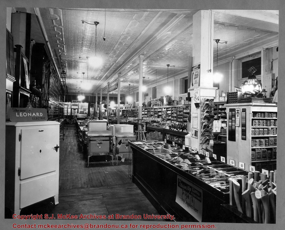
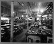
Scope and Content
Item is a photograph of of the interior of the Brandon Hardware Co. Ltd. looking towards the front of the store from the back.
Brandon Hardware Co. Ltd. founded in 1882, making it one of Brandon's earliest mercantiles. It was incorporated in 1902, and their location on Rosser Avenue at the corner of 7th Street was constructed in 1903. For a number of years, J.B. Curran was the managing director. The building was destroyed by fire in 1983.
Custodial History
Katy Singleton was given this photo in her role as Heritage Coordinator for the City of Brandon. She transferred it to the McKee Archives in 2013.
Scope and Content
Item is a photograph of of the interior of the Brandon Hardware Co. Ltd. looking towards the back of the store from the front.
John Hanbury came to Brandon in January 1882. For the next decade he operated a contracting business, constructing several Brandon buildings including the post office, the Merchants Block, and the General Hospital. In 1892, Hanbury founded the Hanbury Manufacturing Company. The most important industry in Brandon from 1900-1914, Hanbury’s employed over 150 men in logging, lumbering and the manufacturing of doors, windows, furniture and other house fixtures.
With offices, a warehouse and lumber mill on either side of Assiniboine Avenue at 6th Street North, Hanbury’s relied on timber from northern forests that was moved, raft-like, down river by drivers. Cabinets, furniture and other millwork was sold out of the Hanbury Hardware Co. building on 7th Street and Pacific Avenue. John Hanbury left Brandon in 1910, although his son continued to operate the business until World War I.
Residential buildings were constructed on the company lands on Assiniboine Avenue west of 6th Street North in the late 1920s; the building east of 6th Street was used first as the Christie’s School Supplies warehouse (1929-1939) and then by successive woollen mills (1941-1991). A portion of what appears to be the original building currently stands vacant on the site. The hardware building on Pacific Avenue has been primarily used by the Government Liquor Control Commission (1929-1971) and Christie’s School Supplies, now Christie’s Office Plus (early 1940s – present).
Custodial History
Photos belonged to Jim Lanigan's family. He donated them to the McKee Archives in January 2017.
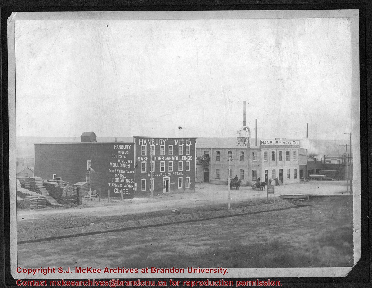
Scope and Content
Item is a photograph of the Hanbury Mfg Co. buildings on Assinboine Avenue - photo is looking northeast
Notes
Jim Lanigan and his siblings beleived that Hanbury Manufacturing Company is where their paternal grandfather James Joseph Lanigan worked and learned the glazing trade. James Joseph's father James and brother Albert Daniel may have also worked there. Both Joe and Bert went to work for the CPR in Brandon in 1898. Jim Lanigan could not identify any family members in the group portrait.


