Skip header and navigation

Revise Search

33 records – page 1 of 2.

Curries Landing (Assiniboine River)

http://archives.brandonu.ca/en/permalink/descriptions11132
Part Of
RG 11 Lawrence Stuckey fonds
Description Level
Item
GMD
graphic
Date Range
Apr. 12, 1977
Part Of
RG 11 Lawrence Stuckey fonds
Creator
L.A. Stuckey
Description Level
Item
Series Number
3.3
Item Number
1-2002.3.3.BSE[366a]
GMD
graphic
Date Range
Apr. 12, 1977
Physical Description
2.5" x 2.5"
Material Details
Negative
Custodial History
For custodial history see the collection level description of the Lawrence Stuckey collection.
Scope and Content
Image of Curries Landing (Assiniboine River).
Notes
[Brandon SE includes communities south of Trans-Canada #1 highway and east of PTH #10.]
Name Access
Curries Landing
Assiniboine River
Subject Access
Rivers
Storage Location
Lawrence Stuckey collection
Arrangement
[Mr. Stuckey put three negatives in the same envelope. We have separated them and numbered the negatives (366a) to(366c)].
Images
Show Less

Curries Landing (Assiniboine River)

http://archives.brandonu.ca/en/permalink/descriptions11134
Part Of
RG 11 Lawrence Stuckey fonds
Description Level
Item
GMD
graphic
Date Range
Apr. 12, 1977
Part Of
RG 11 Lawrence Stuckey fonds
Creator
L.A. Stuckey
Description Level
Item
Series Number
3.3
Item Number
1-2002.3.3.BSE[366b]
GMD
graphic
Date Range
Apr. 12, 1977
Physical Description
2.5" x 2.5"
Material Details
Negative
Custodial History
For custodial history see the collection level description of the Lawrence Stuckey collection.
Scope and Content
Image of Curries Landing (Assiniboine River).
Notes
[Brandon SE includes communities south of Trans-Canada #1 highway and east of PTH #10.]
Name Access
Curries Landing
Assiniboine River
Subject Access
Rivers
Storage Location
Lawrence Stuckey collection
Arrangement
[Mr. Stuckey put three negatives in the same envelope. We have separated them and numbered the negatives (366a) to(366c)].
Images
Show Less

Curries Landing (Assiniboine River)

http://archives.brandonu.ca/en/permalink/descriptions11135
Part Of
RG 11 Lawrence Stuckey fonds
Description Level
Item
GMD
graphic
Date Range
Apr. 12, 1977
Part Of
RG 11 Lawrence Stuckey fonds
Creator
L.A. Stuckey
Description Level
Item
Series Number
3.3
Item Number
1-2002.3.3.BSE[366c]
GMD
graphic
Date Range
Apr. 12, 1977
Physical Description
2.5" x 2.5"
Material Details
Negative
Custodial History
For custodial history see the collection level description of the Lawrence Stuckey collection.
Scope and Content
Image of Curries Landing (Assiniboine River).
Notes
[Brandon SE includes communities south of Trans-Canada #1 highway and east of PTH #10.]
Name Access
Curries Landing
Assiniboine River
Subject Access
Rivers
Storage Location
Lawrence Stuckey collection
Arrangement
[Mr. Stuckey put three negatives in the same envelope. We have separated them and numbered the negatives (366a) to(366c)].
Images
Show Less
Part Of
CKX fonds
Description Level
Item
GMD
graphic
Date Range
after 1954
Accession Number
11-2010
Part Of
CKX fonds
Creator
CKX
Description Level
Item
Series Number
S
Item Number
11-2010.S116k
Accession Number
11-2010
GMD
graphic
Date Range
after 1954
Physical Description
5" x 4" (b/w)
Material Details
Negative
Custodial History
See fonds level of the CKX records for custodial history.
Scope and Content
Image of the Assiniboine River.
Name Access
CKX
Assiniboine River
Subject Access
winter
Rivers
bridges
building exteriors
trees
Storage Location
CKX fonds - 2010 accessions
Images
Show Less
Part Of
CKX fonds
Description Level
Item
GMD
graphic
Date Range
after 1954
Accession Number
11-2010
Part Of
CKX fonds
Creator
CKX
Description Level
Item
Series Number
S
Item Number
11-2010.S116j
Accession Number
11-2010
GMD
graphic
Date Range
after 1954
Physical Description
5" x 4" (b/w)
Material Details
Negative
Custodial History
See fonds level of the CKX records for custodial history.
Scope and Content
Image of people swimming in the Assiniboine River.
Name Access
CKX
Assiniboine River
Subject Access
Rivers
building exteriors
persons
swimming
cars
Storage Location
CKX fonds - 2010 accessions
Images
Show Less
Part Of
CKX fonds
Description Level
Item
GMD
graphic
Date Range
1968
Accession Number
11-2010
Part Of
CKX fonds
Creator
CKX
Description Level
Item
Series Number
S
Item Number
11-2010.S31b
Accession Number
11-2010
GMD
graphic
Date Range
1968
Physical Description
1.5" x 1.5" (b/w)
Material Details
Negative
Custodial History
See fonds level of the CKX records for custodial history.
Scope and Content
Image of the St.Lazar bridge.
Name Access
CKX
Subject Access
bridges
signs and signboards
Rivers
Storage Location
CKX fonds - 2010 accessions
Images
Show Less
Part Of
CKX fonds
Description Level
Item
GMD
graphic
Date Range
1968
Accession Number
11-2010
Part Of
CKX fonds
Creator
CKX
Description Level
Item
Series Number
S
Item Number
11-2010.S31a
Accession Number
11-2010
GMD
graphic
Date Range
1968
Physical Description
1.5" x 1.5" (b/w)
Material Details
Negative
Custodial History
See fonds level of the CKX records for custodial history.
Scope and Content
Image of the St.Lazar bridge.
Name Access
CKX
Subject Access
bridges
Rivers
trees
Storage Location
CKX fonds - 2010 accessions
Images
Show Less
Part Of
Fred McGuinness collection
Description Level
Item
GMD
graphic
Date Range
1900-1924
Part Of
Fred McGuinness collection
Description Level
Item
Series Number
McG 9
Item Number
20-2009.26
GMD
graphic
Date Range
1900-1924
Physical Description
4.25" x 2.5" (b/w)
History / Biographical
Situated in the R.M. of Whitehead on the Little Saskatchewan River, the 10 Mile Dam was a 14 kilometer transmission line that supplied the city of Brandon with power. The Brandon Electric Light Company built the dam in 1900 and it is considered Manitoba's first hydroelectic power generating station. The dam spanned approximately 80 meters and was constructed from timber and reinforced with clay and stone. The station was decommissioned in 1924.
Scope and Content
Photograph shows 10 Mile Dam, also known as the Brandon Dam or Minnedosa River Hydro Plant.
Notes
Writing on the back of the photograph reads: "10 mile dam". Biographical information obtained from Manitoba Historical Society.
Name Access
10 Mile Dam
Ten Mile Dam
Brandon Dam
Minnedosa River Hydro Plant
Brandon Electric Light Company
Little Saskatchewan River
Subject Access
dams
Rivers
hydroelectric dams
hydroelectric generation
Storage Location
RG 5 photograph storage drawer 2 (hanging photos)
Images
Show Less

Fishing at 10 Mile Dam

http://archives.brandonu.ca/en/permalink/descriptions13731
Part Of
Fred McGuinness collection
Description Level
Item
GMD
graphic
Date Range
1906?
Accession Number
20-2009
Part Of
Fred McGuinness collection
Description Level
Item
Series Number
McG 9
Item Number
20-2009.41
Accession Number
20-2009
GMD
graphic
Date Range
1906?
Physical Description
6.5" x 4.75" (b/w)
Material Details
reproduction
History / Biographical
Situated in the R.M. of Whitehead on the Little Saskatchewan River, the 10 Mile Dam was a 14 kilometer transmission line that supplied the city of Brandon with power. The Brandon Electric Light Company built the dam in 1900 and it is considered Manitoba's first hydroelectic power generating station. The dam spanned approximately 80 meters and was constructed from timber and reinforced with clay and stone. The station was decommissioned in 1924. Alonzo Archibald Rowe (b. 1862, London, ON; d. 22 Oct 1951, Brandon). The Rowes were considered Brandon area pioneers. Alonzo’s father, Alonzo L. Rowe, came to Brandon with his family in 1881, where the family had a furniture and undertaker business on the west side of 10th Street between Rosser and Princess Avenues. In 1885, the family began farming west of Brandon and Alonzo Archibald served as a councilor and then a reeve in the R.M. of Whitehead. He returned to Brandon in 1907 and served with the Brandon Police Department until 1910, when he returned to farming, this time in Arrow River. A.A. Rowe returned to Brandon in 1915 to work as a Provincial Licenses Inspector, a position he held until 1938. (Source: Obituary, Brandon Daily Sun 22 Oct 1951)
Custodial History
Photograph was in possession of Mrs. Ruby Miles, who passed the image on to Fred McGuinness. McGuinness makes reference to Mrs. Miles and this photograph in his Sunbeams column (Source: F.A. Rosser, "Another interesting chat with a daughter of the plains," Brandon Sun 18 Aug 1981).
Scope and Content
Photograph shows four fishermen at 10 Mile Dam, also known as the Brandon Dam or Minnedosa River Hydro Plant. The fishermen in the photo are identified as George H. Rowe and his father A.A. Rowe, Dr. Wilfred Bigelow, and Al Collins.
Notes
Writing on the back of the photograph reads: at Brandon Dam, [right to left] son and father - George H. ROWE, Mr. A.A. ROWE, Dr. BIGELOW, Al COLLINS (dam?, 1906?, George born March 1897); Jerrett's Photo-Services, May 7 1938.
Name Access
10 Mile Dam
Ten Mile Dam
Brandon Dam
Minnedosa River Hydro Plant
Brandon Electric Light Company
Little Saskatchewan River
George H. Rowe
A.A. Rowe
Dr. Bigelow
Al Collins
Subject Access
dams
Rivers
fishing
Storage Location
RG 5 photograph storage drawer 2 (hanging photos)
Related Material
Ruby Miles collection 14-2003
Images
Show Less

Morning reflection of Brandon's skyline on the Assiniboine River

http://archives.brandonu.ca/en/permalink/descriptions13781
Part Of
Fred McGuinness collection
Description Level
Item
GMD
graphic
Date Range
[1980s]
Accession Number
20-2009
Part Of
Fred McGuinness collection
Creator
Photographer: Sandy Black
Description Level
Item
Series Number
McG 9
Item Number
20-2009.92
Accession Number
20-2009
GMD
graphic
Date Range
[1980s]
Physical Description
5.5" x 3.5" (colour)
Material Details
postcard
Scope and Content
Postcard shows the 100 block of 10th Street facing north. The CPR train station can be seen at the end of 10th Street. The sign for the Rex Cafe is visible on the west side of 10th Street. On the east side of 10th Street, billboards for Campbell & Campbell furniture are visible as well as signs for Pianos and the Orpheum Theatre. Motorists and cyclists share the road. Street car tracks run the length of 10th Street.
Notes
Back of postcard reads: Morning reflection of Brandon's skyline on the Assiniboine River, photo by Sandy Black, printed in Brandno, Manitoba, Canada by Leech Printing Ltd.
Name Access
Assiniboine River
McKenzie Seeds
Scotia Towers
Subject Access
Rivers
downtown
Storage Location
RG 5 photograph storage drawer 2 (hanging photos)
Images
Show Less
Part Of
Fred McGuinness collection
Description Level
Item
GMD
graphic
Date Range
1900-1924
Accession Number
20-2009
Part Of
Fred McGuinness collection
Description Level
Item
Series Number
McG 9
Item Number
20-2009.95
Accession Number
20-2009
GMD
graphic
Date Range
1900-1924
Physical Description
4.25" x 2.5" (b/w)
History / Biographical
Situated in the R.M. of Whitehead on the Little Saskatchewan River, the 10 Mile Dam was a 14 kilometer transmission line that supplied the city of Brandon with power. The Brandon Electric Light Company built the dam in 1900 and it is considered Manitoba's first hydroelectic power generating station. The dam spanned approximately 80 meters and was constructed from timber and reinforced with clay and stone. The station was decommissioned in 1924.
Scope and Content
Photograph shows 10 Mile Dam, also known as the Brandon Dam or Minnedosa River Hydro Plant. The dam's timber construction is quite evident in the picture.
Notes
Writing on the back of the photograph reads: McGuinness (Manitoba Hydro), on Little Saskatchewan.
Name Access
10 Mile Dam
Ten Mile Dam
Brandon Dam
Minnedosa River Hydro Plant
Brandon Electric Light Company
Little Saskatchewan River
Subject Access
dams
Rivers
hydroelectric dams
hydroelectric generation
Storage Location
RG 5 photograph storage drawer 2 (hanging photos)
Related Material
Lawrence Stuckey collection 1-2002.3.1J1
Images
Show Less
Part Of
Fred McGuinness collection
Description Level
Item
GMD
graphic
Date Range
[19--]
Accession Number
20-2009
Other Title Info
Formerly called "bridge over Souris River?"
Part Of
Fred McGuinness collection
Description Level
Item
Series Number
McG 9
Item Number
20-2009.100
Accession Number
20-2009
GMD
graphic
Date Range
[19--]
Physical Description
10" x 8" (b/w)
History / Biographical
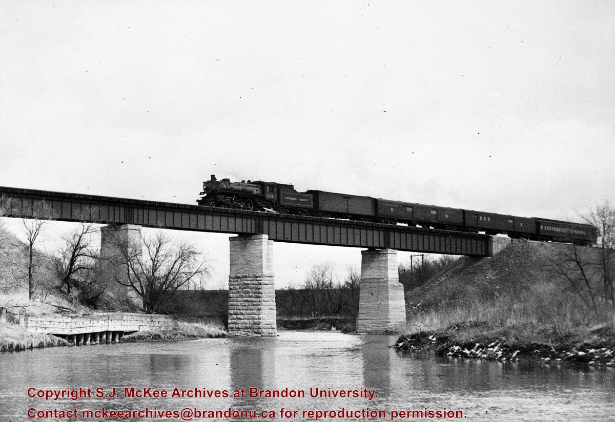
Kirkham's Bridge was built in 1906, to replace an earlier wooden bridge. The bridge was used until 1981, when it was purchased by the Town of Birtle and moved to a newsite. A former railway pridge was installed in its place.
Scope and Content
Photograph shows Kirkham's Bridge, a steel truss bridge that spanned the Little Saskatchewan River in the Municipality of Riverdale.
Notes
Identification of the bridge provided by Ken Storie (2023). Additional information taken from the Manitoba Historical Society website.
Subject Access
bridges
Rivers
Storage Location
RG 5 photograph storage drawer 2 (hanging photos)
Images
Show Less

Fred McGuinness and the Canadian Centennial Commission

http://archives.brandonu.ca/en/permalink/descriptions13890
Part Of
Fred McGuinness collection
Description Level
Item
GMD
graphic
Date Range
1965
Accession Number
20-2009
Part Of
Fred McGuinness collection
Description Level
Item
Series Number
McG 9
Item Number
20-2009.200
Accession Number
20-2009
GMD
graphic
Date Range
1965
Physical Description
7" x 5" (b/w)
Scope and Content
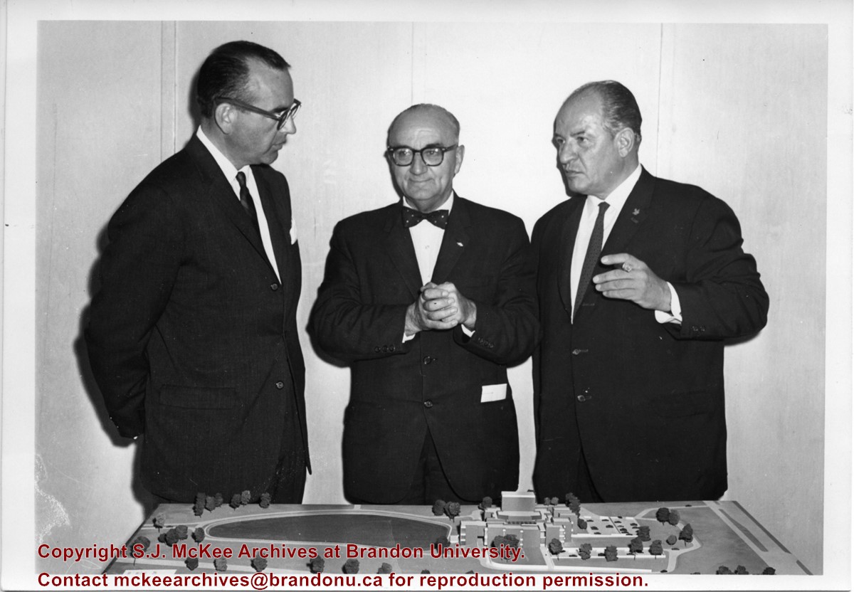
Photograph shows Fred McGuinness standing with Newfoundland Premier Joey Smallwood (centre) and the Centennial Commissioner John Fisher (right). The men are standing before an architectural model.
Notes
Writing on the back of the photograph reads: On tour of Newfoundland as member, board of directors Canadian Centennial Commission, McG, Premier Smallwood, & John Fisher, Centennial Commissioner, 1965
Name Access
Fred McGuinness
Canadian Centennial Commission
Joey Smallwood
John Fisher
Subject Access
portraits
anniversaries
centennials
Storage Location
RG 5 photograph storage drawer 2 (hanging photos)
Arrangement
From 20-2009 #4 plastic envelope #1
Images
Show Less

City of Brandon "See you in '82" float

http://archives.brandonu.ca/en/permalink/descriptions14318
Part Of
Brandon and Area Photograph Collection
Description Level
Item
GMD
graphic
Date Range
c. 1980
Part Of
Brandon and Area Photograph Collection
Description Level
Item
Series Number
2
Item Number
BAPC 2.44
GMD
graphic
Date Range
c. 1980
Physical Description
5" x 8" (b/w)
Scope and Content
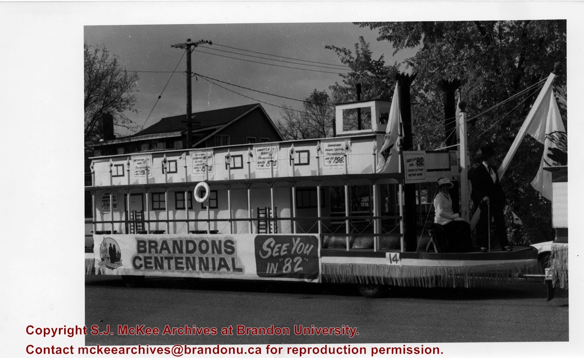
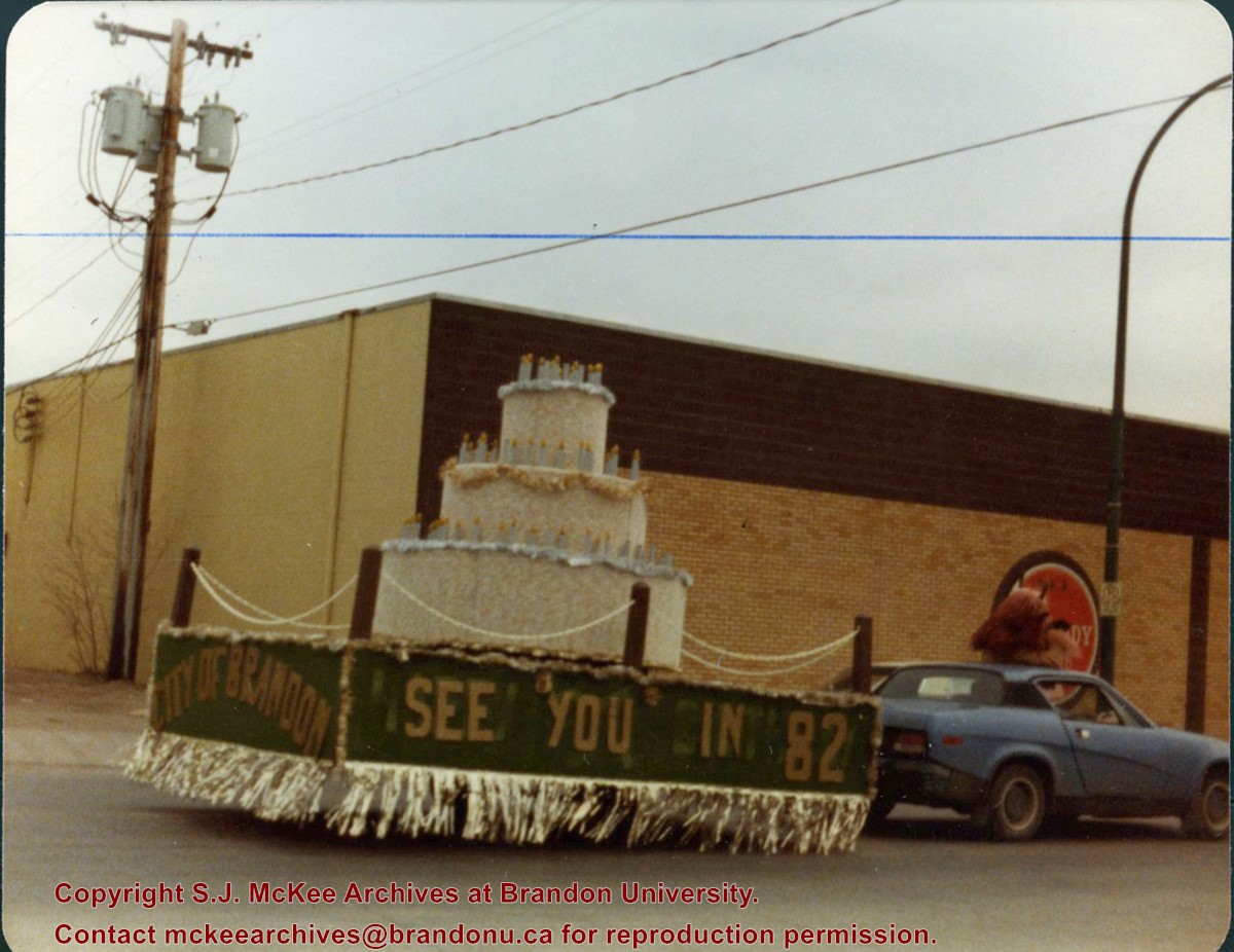
Item is a photograph of the City of Brandon's "See you in '82" float advertising Brandon's upcoming Centennial in 1982. The float is a steamboat and features a number of posters.
Name Access
City of Brandon
Subject Access
parades
floats
centennials
celebrations
Storage Location
BAPC photograph drawer
Images
Show Less

Stephen and Grace Magnacca

http://archives.brandonu.ca/en/permalink/descriptions14319
Part Of
Brandon and Area Photograph Collection
Description Level
Item
GMD
graphic
Date Range
1967
Part Of
Brandon and Area Photograph Collection
Description Level
Item
Series Number
5
Item Number
BAPC 5.12
GMD
graphic
Date Range
1967
Physical Description
10.25" x 8" (b/w)
History / Biographical
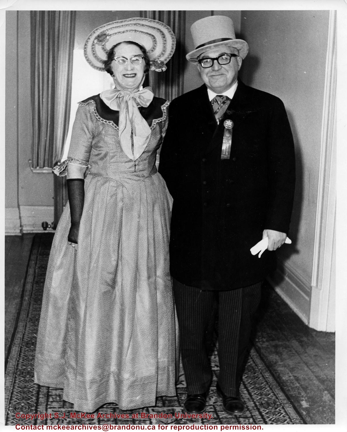
Stephen Adolph Magnacca was born December 10, 1902 in Winnipeg, MB. He joined the Winnipeg Highland Cadets in 1914, and at the age of 15, he added two years to his age and joined the Winnipeg Light Infantry. He was commissioned as a Lieutenant on June 15, 1923. In 1933, he was promoted to the rank of Major. In 1956, he was made an honorary Lieutenant Colonel of the 26th Field Artillery Regiment; he was made a Colonel in 1967. Magnacca married Grace Rosina Jones in 1927 and together they had two children: Patricia and Allan. Grace Jones was born in Cardiff, Wales on November 22, 1901. She came to Winnipeg as a child. For a few years before her marriage she worked as the circulation manager of The Nor'West Farmer. Members of St. Matthew's Church, Grace Magnacca was active in the Anglican Church Women of Canada (ACW). Following her husband's death she moved to Winnipeg. Grace Magnacca died in Winnipeg, MB on December 20, 2004. The Maganacca family lived in Winnipeg until Magnacca's military career took him to Brandon in 1940; his family followed in 1942. The Magnacca's ran an Officer's Kit Shop and then in 1947, opened a real estate business named Magnacca Agencies. Magnacca served two terms as Mayor of Brandon (1961-1969). He was also President of the Assiniboine Historical Society. For meritorious community service, Magnacca was given a Manitoba Golden Boy Award (1969) and a Queen Elizabeth II Silver Jubilee Medal. Stephen Magnacca died on August 4, 1980 in Brandon, MB. He is commemmorated by Magnacca Crescent in Brandon and the Magnacca Research Centre at the Daly House Museum. He was elected a Life member of the Union of Manitoba Municipalities and in 1973, he was made a Member of the Order of Canada.
Scope and Content
Item is a photograph of Mayor Stephen Magnacca and his wife Grace Magnacca dressed in period costumes for Canada's Centennial in 1967.
Notes
History/Bio information taken from the Manitoba Historical Society website (http://www.mhs.mb.ca/docs/people/magnacca_sa.shtml) and the December 31, 1969 Brandon Sun article Experience of being the wife of the mayor has brought satisfaction to Mrs. Magnacca.
Name Access
Stephen Magnacca
Grace Magnacca
Subject Access
celebrations
centennials
mayors
Storage Location
BAPC photograph drawer
Images
Show Less

Wawanesa World War I memorial dedication

http://archives.brandonu.ca/en/permalink/descriptions10111
Part Of
RG 12 Brandon and Area Photograph Collection
Description Level
Item
GMD
graphic
Date Range
November 11, 1921
Part Of
RG 12 Brandon and Area Photograph Collection
Description Level
Item
Series Number
1
Item Number
BAPC 1.5
GMD
graphic
Date Range
November 11, 1921
Physical Description
7.5" x 9" (b/w)
Material Details
On matting
History / Biographical
Erected by the village of Wawanesa, the memorial is dedicated to the local citizens who died as a result of the First and Second World Wars. It was unveiled on November 11, 1921.
Scope and Content
Photograph shows the dedication of a war memorial in the village of Wawanesa, MB. The memorial is located near the bank of the Souris River. The photograph was taken from Wawanesa Mutual. The street on the left is 4th Street.
Notes
History/Bio information taken from the Canadian National Defense website.
Name Access
Wawanesa
Wawanesa Mutual
Souris River
World War I
First World War
Great War
Subject Access
public ceremonies
main streets
monuments
Rivers
dedications
Storage Location
BAPC photograph drawer
Images
Show Less

City of Brandon parade float

http://archives.brandonu.ca/en/permalink/descriptions10118
Part Of
RG 12 Brandon and Area Photograph Collection
Description Level
Item
GMD
graphic
Date Range
October 1980
Part Of
RG 12 Brandon and Area Photograph Collection
Description Level
Item
Series Number
2
Item Number
BAPC 2.5
GMD
graphic
Date Range
October 1980
Physical Description
3.5" x 4.5" (color)
Scope and Content
Photograph of the City of Brandon float advertising Brandon's Centennial in 1982.
Name Access
City of Brandon
Subject Access
centennials
parades
floats
public ceremonies
Storage Location
BAPC photograph drawer
Images
Show Less

Great Northern Railway construction

http://archives.brandonu.ca/en/permalink/descriptions10150
Part Of
RG 12 Brandon and Area Photograph Collection
Description Level
Item
GMD
graphic
Date Range
[19--]
Part Of
RG 12 Brandon and Area Photograph Collection
Description Level
Item
Series Number
3
Item Number
BAPC 3.4
GMD
graphic
Date Range
[19--]
Physical Description
5.5" x 3.25" (b/w)
History / Biographical
Bunclody, MB was located near Souris, MB. The bridge in question crossed the Souris River.
Custodial History
Photograph was donated by a "Mrs. Wilson" in 1989.
Scope and Content
Photograph shows the Great Northern Railway bridge or trestle at Bunclody, MB in winter.
Name Access
Great Northern Railway
Bunclody, MB
Souris River
Subject Access
rail transportation
bridges
Rivers
manmade geographic features
construction of railroads
Storage Location
BAPC photograph drawer
Images
Show Less

Great Northern Railway construction

http://archives.brandonu.ca/en/permalink/descriptions10151
Part Of
RG 12 Brandon and Area Photograph Collection
Description Level
Item
GMD
graphic
Date Range
[19--]
Part Of
RG 12 Brandon and Area Photograph Collection
Description Level
Item
Series Number
3
Item Number
BAPC 3.5
GMD
graphic
Date Range
[19--]
Physical Description
5.5" x 3.25" (b/w)
History / Biographical
Bunclody, MB was located near Souris, MB. The bridge in question crossed the Souris River.
Custodial History
Photograph was donated by a "Mrs. Wilson" in 1989.
Scope and Content
Photograph shows the Great Northern Railway bridge or trestle at Bunclody, MB in spring or fall.
Name Access
Great Northern Railway
Bunclody, MB
Souris River
Subject Access
rail transportation
bridges
Rivers
manmade geographic features
Storage Location
BAPC photograph drawer
Images
Show Less

Great Northern Railway near Bunclody, MB

http://archives.brandonu.ca/en/permalink/descriptions10152
Part Of
RG 12 Brandon and Area Photograph Collection
Description Level
Item
GMD
graphic
Date Range
[19--]
Part Of
RG 12 Brandon and Area Photograph Collection
Description Level
Item
Series Number
3
Item Number
BAPC 3.6
GMD
graphic
Date Range
[19--]
Physical Description
5.5" x 3.25" (b/w)
History / Biographical
Bunclody, MB was located near Souris, MB. The bridge in question crossed the Souris River.
Custodial History
Photograph was donated by a "Mrs. Wilson" in 1989.
Scope and Content
Photograph shows a portion of the Great Northern Railway track with the Bunclody bridge in the background. Also visible are a couple of houses, railway cars, lumber and part of the Souris River. The photograph was taken in early winter or early spring.
Name Access
Great Northern Railway
Bunclody, MB
Souris River
Subject Access
rail transportation
bridges
Rivers
manmade geographic features
Storage Location
BAPC photograph drawer
Images
Show Less

33 records – page 1 of 2.