Skip header and navigation

Revise Search

53 records – page 1 of 3.

Curries Landing (Assiniboine River)

http://archives.brandonu.ca/en/permalink/descriptions11132
Part Of
RG 11 Lawrence Stuckey fonds
Description Level
Item
GMD
graphic
Date Range
Apr. 12, 1977
Part Of
RG 11 Lawrence Stuckey fonds
Creator
L.A. Stuckey
Description Level
Item
Series Number
3.3
Item Number
1-2002.3.3.BSE[366a]
GMD
graphic
Date Range
Apr. 12, 1977
Physical Description
2.5" x 2.5"
Material Details
Negative
Custodial History
For custodial history see the collection level description of the Lawrence Stuckey collection.
Scope and Content
Image of Curries Landing (Assiniboine River).
Notes
[Brandon SE includes communities south of Trans-Canada #1 highway and east of PTH #10.]
Name Access
Curries Landing
Assiniboine River
Subject Access
Rivers
Storage Location
Lawrence Stuckey collection
Arrangement
[Mr. Stuckey put three negatives in the same envelope. We have separated them and numbered the negatives (366a) to(366c)].
Images
Show Less

Curries Landing (Assiniboine River)

http://archives.brandonu.ca/en/permalink/descriptions11134
Part Of
RG 11 Lawrence Stuckey fonds
Description Level
Item
GMD
graphic
Date Range
Apr. 12, 1977
Part Of
RG 11 Lawrence Stuckey fonds
Creator
L.A. Stuckey
Description Level
Item
Series Number
3.3
Item Number
1-2002.3.3.BSE[366b]
GMD
graphic
Date Range
Apr. 12, 1977
Physical Description
2.5" x 2.5"
Material Details
Negative
Custodial History
For custodial history see the collection level description of the Lawrence Stuckey collection.
Scope and Content
Image of Curries Landing (Assiniboine River).
Notes
[Brandon SE includes communities south of Trans-Canada #1 highway and east of PTH #10.]
Name Access
Curries Landing
Assiniboine River
Subject Access
Rivers
Storage Location
Lawrence Stuckey collection
Arrangement
[Mr. Stuckey put three negatives in the same envelope. We have separated them and numbered the negatives (366a) to(366c)].
Images
Show Less

Curries Landing (Assiniboine River)

http://archives.brandonu.ca/en/permalink/descriptions11135
Part Of
RG 11 Lawrence Stuckey fonds
Description Level
Item
GMD
graphic
Date Range
Apr. 12, 1977
Part Of
RG 11 Lawrence Stuckey fonds
Creator
L.A. Stuckey
Description Level
Item
Series Number
3.3
Item Number
1-2002.3.3.BSE[366c]
GMD
graphic
Date Range
Apr. 12, 1977
Physical Description
2.5" x 2.5"
Material Details
Negative
Custodial History
For custodial history see the collection level description of the Lawrence Stuckey collection.
Scope and Content
Image of Curries Landing (Assiniboine River).
Notes
[Brandon SE includes communities south of Trans-Canada #1 highway and east of PTH #10.]
Name Access
Curries Landing
Assiniboine River
Subject Access
Rivers
Storage Location
Lawrence Stuckey collection
Arrangement
[Mr. Stuckey put three negatives in the same envelope. We have separated them and numbered the negatives (366a) to(366c)].
Images
Show Less

British American dealers - credit books

http://archives.brandonu.ca/en/permalink/descriptions11205
Part Of
CKX fonds
Description Level
Item
GMD
graphic
Date Range
after 1954
Accession Number
11-2010
Part Of
CKX fonds
Creator
CKX
Description Level
Item
Item Number
11-2010.B2r
Accession Number
11-2010
GMD
graphic
Date Range
after 1954
Physical Description
5" x 4" (b/w)
Material Details
Negative
Custodial History
See fonds level of the CKX records for custodial history.
Scope and Content
Image consists of British American dealers - credit books.
Name Access
CKX
British American Dealers
Subject Access
automobile dealerships
Bookkeeping
Storage Location
CKX fonds - 2010 accessions
Images
Show Less

Trappers' festival

http://archives.brandonu.ca/en/permalink/descriptions12966
Part Of
CKX fonds
Description Level
Item
GMD
graphic
Date Range
after 1954
Accession Number
11-2010
Part Of
CKX fonds
Creator
CKX
Description Level
Item
Series Number
T
Item Number
11-2010.T29h
Accession Number
11-2010
GMD
graphic
Date Range
after 1954
Physical Description
1.5" x 1.5" (b/w)
Material Details
Negative
Custodial History
See fonds level of the CKX records for custodial history.
Scope and Content
Image of people and dogs standing in the snow.
Name Access
CKX
Subject Access
persons
dogs
winter
building exteriors
Storage Location
CKX fonds - 2010 accessions
Images
Show Less

Trappers' festival

http://archives.brandonu.ca/en/permalink/descriptions12967
Part Of
CKX fonds
Description Level
Item
GMD
graphic
Date Range
after 1954
Accession Number
11-2010
Part Of
CKX fonds
Creator
CKX
Description Level
Item
Series Number
T
Item Number
11-2010.T29g
Accession Number
11-2010
GMD
graphic
Date Range
after 1954
Physical Description
1.5" x 1.5" (b/w)
Material Details
Negative
Custodial History
See fonds level of the CKX records for custodial history.
Scope and Content
Image of a person driving a dogsled.
Name Access
CKX
Subject Access
persons
dogs
winter
building exteriors
vehicles
Storage Location
CKX fonds - 2010 accessions
Images
Show Less
Part Of
CKX fonds
Description Level
Item
GMD
graphic
Date Range
after 1954
Accession Number
11-2010
Part Of
CKX fonds
Creator
CKX
Description Level
Item
Series Number
S
Item Number
11-2010.S116k
Accession Number
11-2010
GMD
graphic
Date Range
after 1954
Physical Description
5" x 4" (b/w)
Material Details
Negative
Custodial History
See fonds level of the CKX records for custodial history.
Scope and Content
Image of the Assiniboine River.
Name Access
CKX
Assiniboine River
Subject Access
winter
Rivers
bridges
building exteriors
trees
Storage Location
CKX fonds - 2010 accessions
Images
Show Less
Part Of
CKX fonds
Description Level
Item
GMD
graphic
Date Range
after 1954
Accession Number
11-2010
Part Of
CKX fonds
Creator
CKX
Description Level
Item
Series Number
S
Item Number
11-2010.S116j
Accession Number
11-2010
GMD
graphic
Date Range
after 1954
Physical Description
5" x 4" (b/w)
Material Details
Negative
Custodial History
See fonds level of the CKX records for custodial history.
Scope and Content
Image of people swimming in the Assiniboine River.
Name Access
CKX
Assiniboine River
Subject Access
Rivers
building exteriors
persons
swimming
cars
Storage Location
CKX fonds - 2010 accessions
Images
Show Less
Part Of
CKX fonds
Description Level
Item
GMD
graphic
Date Range
1968
Accession Number
11-2010
Part Of
CKX fonds
Creator
CKX
Description Level
Item
Series Number
S
Item Number
11-2010.S31b
Accession Number
11-2010
GMD
graphic
Date Range
1968
Physical Description
1.5" x 1.5" (b/w)
Material Details
Negative
Custodial History
See fonds level of the CKX records for custodial history.
Scope and Content
Image of the St.Lazar bridge.
Name Access
CKX
Subject Access
bridges
signs and signboards
Rivers
Storage Location
CKX fonds - 2010 accessions
Images
Show Less
Part Of
CKX fonds
Description Level
Item
GMD
graphic
Date Range
1968
Accession Number
11-2010
Part Of
CKX fonds
Creator
CKX
Description Level
Item
Series Number
S
Item Number
11-2010.S31a
Accession Number
11-2010
GMD
graphic
Date Range
1968
Physical Description
1.5" x 1.5" (b/w)
Material Details
Negative
Custodial History
See fonds level of the CKX records for custodial history.
Scope and Content
Image of the St.Lazar bridge.
Name Access
CKX
Subject Access
bridges
Rivers
trees
Storage Location
CKX fonds - 2010 accessions
Images
Show Less

Reston dealers and merchants - William Lockhart & Sons

http://archives.brandonu.ca/en/permalink/descriptions13322
Part Of
CKX fonds
Description Level
Item
GMD
graphic
Date Range
October 1964
Accession Number
11-2010
Part Of
CKX fonds
Creator
CKX
Description Level
Item
Series Number
R
Item Number
11-2010.R115
Accession Number
11-2010
GMD
graphic
Date Range
October 1964
Physical Description
2.5" x 2.5" (b/w)
Material Details
Negative
Custodial History
See fonds level of the CKX records for custodial history.
Scope and Content
Image of the William Lockhart & Sons building.
Name Access
CKX
William Lockhart & Sons
Subject Access
businesses
building exteriors
cars
dogs
farm implements
garages
Storage Location
CKX fonds - 2010 accessions
Images
Show Less
Part Of
CKX fonds
Description Level
Item
GMD
graphic
Date Range
1967
Accession Number
11-2010
Part Of
CKX fonds
Creator
CKX
Description Level
Item
Series Number
R
Item Number
11-2010.R6
Accession Number
11-2010
GMD
graphic
Date Range
1967
Physical Description
1.5" x 1.5" (b/w)
Material Details
Negative
Custodial History
See fonds level of the CKX records for custodial history.
Scope and Content
Image of a contest winner.
Name Access
CKX
Rowntree
Subject Access
contests
children
dogs
Storage Location
CKX fonds - 2010 accessions
Images
Show Less

Dominion Day on Rosser Avenue

http://archives.brandonu.ca/en/permalink/descriptions13698
Part Of
Fred McGuinness collection
Description Level
Item
GMD
graphic
Date Range
1906
Accession Number
20-2009
Part Of
Fred McGuinness collection
Description Level
Item
Series Number
McG 9
Item Number
20-2009.8
Accession Number
20-2009
GMD
graphic
Date Range
1906
Physical Description
6" x 4" (b/w)
Material Details
on matting
Physical Condition
Photographs have been glued to a backing board that has warped over time
Scope and Content
Photograph shows street view of north side of Rosser Avenue, primarily the 700 block. Horse and buggies are travelling on the avenue and pedestrians fill the sidewalks. Union Jacks and English flags are mounted from the windows on the Fleming and Beaubier blocks. Flag banners are drapped across Rosser Avenue. Businesses visible in the Fleming Block include: Lowes Brothers Clothing and Spring Park Nurseries. Businesses visible in the Beaubier Block include the Empire Hotel. Businesses east of the Empire Hotel are grocer A.M. Percival and the Brandon Hardware Company. An advertisement for the Northern Bank is affixed to a telephone pole on the southside of the street. The street is lined with litter and a number of dogs can be seen roaming the area.
Notes
Writing on the front of the photograph matting reads: 313 July 1906. One photograph (20-2009.8) is glued below and another, 20-2009.6, is glued on the reverse side. Page appears to be from a photo album.
Name Access
Fleming Block
Lowes Brothers Clothing
Spring Park Nurseries Limited
Empire Hotel
D.W. Beaubier Block
A.M. Percival
Brandon Hardware Company
Rosser Avenue
Subject Access
Street scene
Transportation
downtown
grocers
storefronts
Dominion Day
dogs
horses
Storage Location
RG 5 photograph storage drawer 2 (hanging photos)
Images
Show Less

Horse and buggies travelling on Rosser Avenue

http://archives.brandonu.ca/en/permalink/descriptions13699
Part Of
Fred McGuinness collection
Description Level
Item
GMD
graphic
Date Range
[1906]
Accession Number
20-2009
Part Of
Fred McGuinness collection
Description Level
Item
Series Number
McG 9
Item Number
20-2009.9
Accession Number
20-2009
GMD
graphic
Date Range
[1906]
Physical Description
6.5" x 4.25" (b/w)
Material Details
on matting
Physical Condition
Photographs have been glued to a backing board that has warped over time
History / Biographical
Photograph of possible Dakota from Sioux Valley in Brandon for the summer fair.
Scope and Content
Photograph shows street view of north side of Rosser Avenue, primarily the 700 block. Businesses visible in the Fleming Block include: Lowes Brothers Clothing, Robert Hall [Insurance Broker], Manitoba Farmers Hedge and Wire Fence Company. Businesses visible in the Beaubier Block include the Empire Hotel. Businesses east of the Empire Hotel are grocer A.M. Percival and the Brandon Hardware Company. A number of Aboriginal peoples are driving horse and buggies west along Rosser Avenue as spectators look on.
Notes
Writing on the front of the photograph matting reads: 294 July 1906. One photograph (20-2009.10) is glued below and two others are glued on the reverse side. Page appears to be from a photo album.
Name Access
Fleming Block
Lowes Brothers Clothing
Manitoba Farmers Hedge and Wire Fence Company
Empire Hotel
D.W. Beaubier Block
A.M. Percival
Brandon Hardware Company
Rosser Avenue
Subject Access
Street scene
Transportation
downtown
grocers
storefronts
dogs
Aboriginals
First Nations
horses
buggies
insurance agents
Storage Location
RG 5 photograph storage drawer 2 (hanging photos)
Images
Show Less

8th Street and Rosser Avenue intersection

http://archives.brandonu.ca/en/permalink/descriptions13701
Part Of
Fred McGuinness collection
Description Level
Item
GMD
graphic
Date Range
[1906]
Accession Number
20-2009
Part Of
Fred McGuinness collection
Description Level
Item
Series Number
McG 9
Item Number
20-2009.11
Accession Number
20-2009
GMD
graphic
Date Range
[1906]
Physical Description
6.5" x 4.25" (b/w)
Material Details
on matting
Physical Condition
Photograph is scratched and has been glued to a backing board that has warped over time
Scope and Content
Photograph shows street view of intersection of the 000 block of 8th Street and Rosser Avenue. Horse and buggies are travelling on both roads. Businesses on the east side of 8th Street from Pacific to Rosser Avenues are clearly visible and include: a Lunch Room (likely Aagaard's Lunch Counter), the Hotel Imperial Annex, Liverpool House (a boarding house), R.S. Thompson and Company Real Estate Office (Land Office), a barber shop (likely J. Coulter's), Frank Gowen photography studio, and Fleming's Drug Store. A possible street fair is in progress on Rosser Avenue. One man is surrounded by a crowd adjacent to the Fleming Block, another man stands on a soap box in the middle of the intersection, while a third man is standing behind a booth. Building construction appears to be happening on the west corner of 7th Street and Rosser Avenue.
Notes
Writing on the front of the photograph matting reads: 296. One photograph (20-2009.12) is glued above and two others are glued on the reverse side. Page appears to be from a photo album.
Name Access
Fleming Block
Fleming's Drug Store
Frank Gowen Photographer
Liverpool House
Hotel Imperial Annex
8th Street
Rosser Avenue
Aagaard's
R.S. Thompson
8th Street Bridge
Subject Access
Street scene
Transportation
downtown
storefronts
store exteriors
hotels
boarding houses
barber shops
restaurants
druggists
photographers
bridge
horses
dogs
land agents
Storage Location
RG 5 photograph storage drawer 2 (hanging photos)
Images
Show Less

Horse and carriages travelling on Rosser Avenue

http://archives.brandonu.ca/en/permalink/descriptions13702
Part Of
Fred McGuinness collection
Description Level
Item
GMD
graphic
Date Range
[1906]
Accession Number
20-2009
Part Of
Fred McGuinness collection
Description Level
Item
Series Number
McG 9
Item Number
20-2009.12
Accession Number
20-2009
GMD
graphic
Date Range
[1906]
Physical Description
6.5" x 4.25" (b/w)
Material Details
on matting
Physical Condition
Photographs have been glued to a backing board that has warped over time
History / Biographical
Photograph of possible Dakota from Sioux Valley in Brandon for the summer fair.
Scope and Content
Photograph shows street view of north side of Rosser Avenue, primarily the 700 block. Businesses visible in the Fleming Block include: Lowes Brothers Clothing, Robert Hall [Insurance Broker], Manitoba Farmers Hedge and Wire Fence Company. Businesses visible in the Beaubier Block include the Empire Hotel. Businesses east of the Empire Hotel are grocer A.M. Percival and the Brandon Hardware Company. A number of Aboriginal peoples are driving horse and carriages west along Rosser Avenue as spectators look on.
Notes
Writing on the front of the photograph matting reads: 295 July 1906. One photograph (20-2009.11) is glued above and two others are glued on the reverse side. Page appears to be from a photo album.
Name Access
Fleming Block
Lowes Brothers Clothing
Manitoba Farmers Hedge and Wire Fence Company
Empire Hotel
D.W. Beaubier Block
A.M. Percival
Brandon Hardware Company
Rosser Avenue
Subject Access
Street scene
Transportation
downtown
grocers
storefronts
dogs
Aboriginals
First Nations
horses
insurance agents
Storage Location
RG 5 photograph storage drawer 2 (hanging photos)
Images
Show Less

Street scene Rosser Avenue and 8th Street intersection

http://archives.brandonu.ca/en/permalink/descriptions13705
Part Of
Fred McGuinness collection
Description Level
Item
GMD
graphic
Date Range
1906
Accession Number
20-2009
Part Of
Fred McGuinness collection
Description Level
Item
Series Number
McG 9
Item Number
20-2009.15
Accession Number
20-2009
GMD
graphic
Date Range
1906
Physical Description
6.5" x 4.25" (b/w)
Material Details
on matting
Physical Condition
Photographs have been glued to a backing board that has warped over time
Scope and Content
Photograph shows street view of north side of Rosser Avenue, primarily the 700 block. The Fleming Block, Beaubier Block and its Empire Hotel, A.M. Percival (a grocer), the Brandon Hardware Company (600 block), and the Arlington Hotel (500 block) are visible along the north side of the avenue. The Bank of Hamilton Building on the southeast corner of 8th Street and Rosser appears to be under construction. A sign in the second storey window above the main entrance reads: law office. The streets are muddy and a horse and buggy is traveling west on Rosser Avenue.
Notes
Writing on the front of the photograph matting reads: mud November 12, 1906, 339. The photograph appears to be taken from the interior of a builing on the southwest corner of 8th Street and Rosser Avenue. Page appears to be from a photo album.
Name Access
Fleming Block
Empire Hotel
D.W. Beaubier Block
A.M. Percival
Brandon Hardware Company
Rosser Avenue
Subject Access
Street scene
Transportation
downtown
grocers
storefronts
mud
dogs
horses
buggies
insurance agents
lawyers
Storage Location
RG 5 photograph storage drawer 2 (hanging photos)
Images
Show Less

Royal George Hotel

http://archives.brandonu.ca/en/permalink/descriptions13712
Part Of
Fred McGuinness collection
Description Level
Item
GMD
graphic
Date Range
1912
Accession Number
20-2009
Part Of
Fred McGuinness collection
Description Level
Item
Series Number
McG 9
Item Number
20-2009.22
Accession Number
20-2009
GMD
graphic
Date Range
1912
Physical Description
9.75" x 7.5" (b/w)
Physical Condition
photograph is torn and has scotch tape residue
Scope and Content
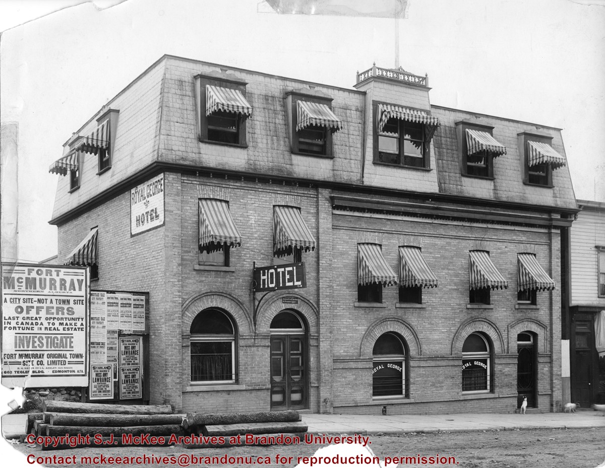
Photograph shows the exterior of the Royal George Hotel located at 142-6th Street, Brandon. Striped awnings cover the second and third storey windows of the hotel. Dogs roam the sidewalk in front of the hotel. Advertisements cover the fence adjacent to the hotel and include: Fort McMurray town site settlement; Mortgage sale for city property; Starland Theatre featuring Miss Amy Lawrence, Soprano; Sherman Theatre; 15th Annual Horticultural Exhibition
Notes
Date ascertained from 15th Annual Horticultural Exhibition advertisement posted on fence adjacent to hotel. Address obtained from Henderson's Brandon City Directory for 1913.
Name Access
Royal George Hotel
Starland Theatre
Sherman Theatre
Horticultural Exhibition
6th Street
Subject Access
hotels
building exteriors
advertising
dogs
Storage Location
RG 5 photograph storage drawer 2 (hanging photos)
Images
Show Less
Part Of
Fred McGuinness collection
Description Level
Item
GMD
graphic
Date Range
1900-1924
Part Of
Fred McGuinness collection
Description Level
Item
Series Number
McG 9
Item Number
20-2009.26
GMD
graphic
Date Range
1900-1924
Physical Description
4.25" x 2.5" (b/w)
History / Biographical
Situated in the R.M. of Whitehead on the Little Saskatchewan River, the 10 Mile Dam was a 14 kilometer transmission line that supplied the city of Brandon with power. The Brandon Electric Light Company built the dam in 1900 and it is considered Manitoba's first hydroelectic power generating station. The dam spanned approximately 80 meters and was constructed from timber and reinforced with clay and stone. The station was decommissioned in 1924.
Scope and Content
Photograph shows 10 Mile Dam, also known as the Brandon Dam or Minnedosa River Hydro Plant.
Notes
Writing on the back of the photograph reads: "10 mile dam". Biographical information obtained from Manitoba Historical Society.
Name Access
10 Mile Dam
Ten Mile Dam
Brandon Dam
Minnedosa River Hydro Plant
Brandon Electric Light Company
Little Saskatchewan River
Subject Access
dams
Rivers
hydroelectric dams
hydroelectric generation
Storage Location
RG 5 photograph storage drawer 2 (hanging photos)
Images
Show Less

Fishing at 10 Mile Dam

http://archives.brandonu.ca/en/permalink/descriptions13731
Part Of
Fred McGuinness collection
Description Level
Item
GMD
graphic
Date Range
1906?
Accession Number
20-2009
Part Of
Fred McGuinness collection
Description Level
Item
Series Number
McG 9
Item Number
20-2009.41
Accession Number
20-2009
GMD
graphic
Date Range
1906?
Physical Description
6.5" x 4.75" (b/w)
Material Details
reproduction
History / Biographical
Situated in the R.M. of Whitehead on the Little Saskatchewan River, the 10 Mile Dam was a 14 kilometer transmission line that supplied the city of Brandon with power. The Brandon Electric Light Company built the dam in 1900 and it is considered Manitoba's first hydroelectic power generating station. The dam spanned approximately 80 meters and was constructed from timber and reinforced with clay and stone. The station was decommissioned in 1924. Alonzo Archibald Rowe (b. 1862, London, ON; d. 22 Oct 1951, Brandon). The Rowes were considered Brandon area pioneers. Alonzo’s father, Alonzo L. Rowe, came to Brandon with his family in 1881, where the family had a furniture and undertaker business on the west side of 10th Street between Rosser and Princess Avenues. In 1885, the family began farming west of Brandon and Alonzo Archibald served as a councilor and then a reeve in the R.M. of Whitehead. He returned to Brandon in 1907 and served with the Brandon Police Department until 1910, when he returned to farming, this time in Arrow River. A.A. Rowe returned to Brandon in 1915 to work as a Provincial Licenses Inspector, a position he held until 1938. (Source: Obituary, Brandon Daily Sun 22 Oct 1951)
Custodial History
Photograph was in possession of Mrs. Ruby Miles, who passed the image on to Fred McGuinness. McGuinness makes reference to Mrs. Miles and this photograph in his Sunbeams column (Source: F.A. Rosser, "Another interesting chat with a daughter of the plains," Brandon Sun 18 Aug 1981).
Scope and Content
Photograph shows four fishermen at 10 Mile Dam, also known as the Brandon Dam or Minnedosa River Hydro Plant. The fishermen in the photo are identified as George H. Rowe and his father A.A. Rowe, Dr. Wilfred Bigelow, and Al Collins.
Notes
Writing on the back of the photograph reads: at Brandon Dam, [right to left] son and father - George H. ROWE, Mr. A.A. ROWE, Dr. BIGELOW, Al COLLINS (dam?, 1906?, George born March 1897); Jerrett's Photo-Services, May 7 1938.
Name Access
10 Mile Dam
Ten Mile Dam
Brandon Dam
Minnedosa River Hydro Plant
Brandon Electric Light Company
Little Saskatchewan River
George H. Rowe
A.A. Rowe
Dr. Bigelow
Al Collins
Subject Access
dams
Rivers
fishing
Storage Location
RG 5 photograph storage drawer 2 (hanging photos)
Related Material
Ruby Miles collection 14-2003
Images
Show Less

53 records – page 1 of 3.