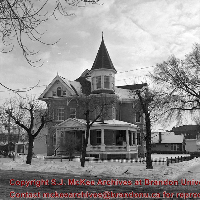
Former home of J.E. Smith, early farmer, horse breeder and businessman - died 1919. Became city property. To Allied Arts Council 1950's. Arts Centre moved to former Co-op Store, 600 block of Princess Ave. 1984.
[In 2000, the renamed Art Gallery of Southwestern Manitoba moved to the former Eaton’s building attached to The Town Centre (former Gallery Mall). P.E. 05/06/09]
Custodial History
For custodial history see the collection level description of the Lawrence Stuckey collection.
Built in 1991-1992 for $1.4 million, the official opening of the Centre was May 29, 1992. The centre is currently (April 2010) called the Addictions Foundation of Manitoba, Parkwood Centre.
Custodial History
For custodial history see the collection level description of the Lawrence Stuckey collection.
Scope and Content
Alcoholism Foundation of Manitoba (AFM), Parkwood Treatment Centre located on Victoria Avenue East.
Built in 1991-1992 for $1.4 million, the official opening of the Centre was May 29, 1992. The centre is currently (April 2010) called the Addictions Foundation of Manitoba, Parkwood Centre.
Custodial History
For custodial history see the collection level description of the Lawrence Stuckey collection.
Scope and Content
Alcoholism Foundation of Manitoba (AFM), Parkwood Treatment Centre.
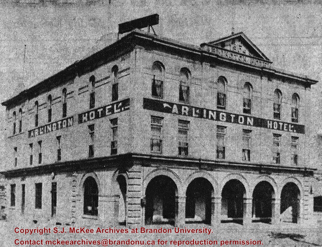
Photograph shows a panorama, bird's-eye-view of downtown Brandon, between Pacific and Rosser Avenues and 7th Street facing east. Photoraph likely taken from the McKenzie Seeds Building. Visible businesses include: Western Canada Flour Mills, Hanbury Hardware Co. Ltd., Cockshutt Plow Co., New Pacific Hotel, Gordon McKay Building, and Arlington Hotel.
Notes
Part of "Souvenir of Brandon, Manitoba, Canada [viewbook], Printed by Photogelatine Engraving Co. Limited, Ottawa." Dates obtained from the Burchill's Music Store Henderson's Brandon City Directory listings (1927-1929). Writing on the front of the photograph reads: Panorama of Brandon, Man.
Photographs have been glued to a backing board that has warped over time
Scope and Content
Photograph shows street view of north side of Rosser Avenue, primarily the 700 block, along which sewer pipe is being laid. Visible buildings and businesses include: The Fleming Block with Lowes Brothers Clothing and Manitoba Farmers Hedge and Wire Fence Company, the Beaubier Block and its Empire Hotel, A.M. Percival (a grocer), the Brandon Hardware Company (600 block), and the Arlington Hotel (500 block) are visible along the north side of the avenue. The Bank of Hamilton Building is on the southeast corner of 8th Street and Rosser Avenue.
Notes
Writing on the front of the photograph matting reads: 290. Page appears to be from a photo album.
.jpg?width=1200&404=no-img.jpg&watermark=wmk)
.jpg?width=180&404=no-img.jpg)
.jpg?width=1200&404=no-img.jpg&watermark=wmk)
.jpg?width=180&404=no-img.jpg)


.jpg%3fmaxheight%3d1000%26maxwidth%3d1000%26watermark%3dwmk&description=Alcoholism+Foundation+of+Manitoba%2c+Parkwood+Treatment+Centre)
.jpg%3fmaxheight%3d1000%26maxwidth%3d1000%26watermark%3dwmk&description=Alcoholism+Foundation+of+Manitoba+Parkwood+Treatment+Centre)