Skip header and navigation

Revise Search

20 records – page 1 of 1.

Twin Pines Motel postcard

http://archives.brandonu.ca/en/permalink/descriptions13868
Part Of
Fred McGuinness collection
Description Level
Item
GMD
graphic
Date Range
1970
Accession Number
20-2009
Part Of
Fred McGuinness collection
Creator
Photographer: Joe Fartak
Description Level
Item
Series Number
McG 9
Item Number
20-2009.178
Accession Number
20-2009
GMD
graphic
Date Range
1970
Physical Description
3.5" x 6" (colour)
Material Details
postcard
Scope and Content
Postcard shows an exterior view of the Twin Pines Motel
Notes
Writing on the back of the postcard reads: Twin Pines Motel & Restaurant / Brandon, Manitoba, Canada / Located at 10th Street & Queens Avenue / 40 Fully modern units with bath & showers, T. / Kichenettes, winter plug-ins, Ample parking. / For reservations call.... / 30717-C Color Photo by Joe Fartak / Color Productions Ltd., Box 1243, Regina, Sask. The postcard is addressed to Mr. F.A. Rosser and is postmarked Brandon 06 June 1970. A 6-cent Queen Elizabeth red postage stamp portraying various modes of the transportation.
Name Access
City of Brandon
Subject Access
aerial photographs
aerial views
Brandon business buildings & facilities after 1940
Storage Location
RG 5 photograph storage drawer 2 (hanging photos)
Arrangement
From 20-2009 #1 File 13 Sunbeams
Images
Show Less

World War I soldiers march down Rosser Avenue

http://archives.brandonu.ca/en/permalink/descriptions10125
Part Of
RG 12 Brandon and Area Photograph Collection
Description Level
Item
GMD
graphic
Date Range
c. 1914
Accession Number
24-1999
Part Of
RG 12 Brandon and Area Photograph Collection
Description Level
Item
Series Number
2
Item Number
BAPC 2.12
Accession Number
24-1999
GMD
graphic
Date Range
c. 1914
Physical Description
7.5" x 9.5" (b/w)
Physical Condition
There are two burn holes and many areas where the emulsion layer is gone.
History / Biographical
John A. McDonald's was a men's and boyswear store in operation for several decades at 841 Rosser Avenue, Brandon, MB.
Scope and Content
Photograph of soldiers marching west on Rosser Avenue.
Name Access
John A. McDonald's
Diamond Hall
W.E. Crawford
The Patricia
World War I
First World War
Great War
Rosser Avenue
Subject Access
public ceremonies
armed forces
military personnel
parades
downtown
cityscapes
Storage Location
BAPC photograph drawer
Images
Show Less

Aerial view - Brandon College looking southwest

http://archives.brandonu.ca/en/permalink/descriptions601
Part Of
Brandon University Photograph collection
Description Level
Item
GMD
graphic
Date Range
[1963-1966]
Part Of
Brandon University Photograph collection
Description Level
Item
Series Number
2.1
Item Number
BUPC 2.1.8
GMD
graphic
Date Range
[1963-1966]
Physical Description
5" x 4" (b/w)
Scope and Content
Image shows the Brandon College campus from 17th Street looking southwest. The photo was taken after the completion of the original Music Building in 1963, but construction of the Education Building. Also visible are a number of properties on the 200 block of 18th Street and the 200 block of 20th Street.
Subject Access
aerial photographs
campus photographs
campus buildings
Brandon streets
Images
Show Less

Downtown of Brandon - Rosser Avenue looking east

http://archives.brandonu.ca/en/permalink/descriptions11703
Part Of
CKX fonds
Description Level
Item
GMD
graphic
Date Range
after 1954
Accession Number
11-2010
Part Of
CKX fonds
Creator
CKX
Description Level
Item
Item Number
11-2010.B139c
Accession Number
11-2010
GMD
graphic
Date Range
after 1954
Physical Description
2.25" x 2.25" (b/w)
Material Details
Negative
Custodial History
See fonds level of the CKX records for custodial history.
Scope and Content
Image of Rosser Avenue looking east from 11th Street.
Name Access
CKX Television
Brandon, Manitoba
Subject Access
cityscapes
Storage Location
CKX fonds - 2010 accessions
Images
Show Less

Aerial view: Brandon College from 23rd Street

http://archives.brandonu.ca/en/permalink/descriptions602
Part Of
Brandon University Photograph collection
Description Level
Item
GMD
graphic
Date Range
[1963-1966]
Part Of
Brandon University Photograph collection
Description Level
Item
Series Number
2.1
Item Number
BUPC 2.1.9
GMD
graphic
Date Range
[1963-1966]
Physical Description
5" x 4" (b/w)
Scope and Content
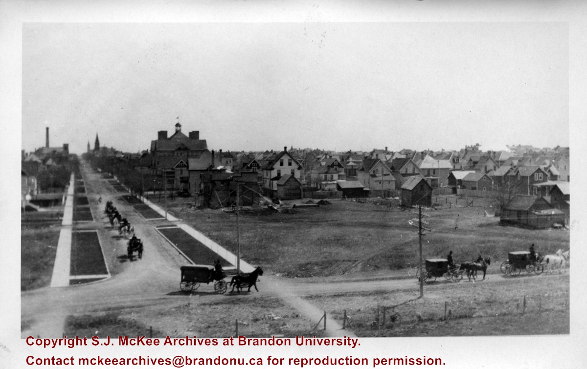
Image is looking east northeast from approximately the 300 block of 23rd Street between Lorne and Louise Avenues. Photograph shows the Brandon College campus after the opening of the original Music Building in 1963, but before the construction of the Education Building in 1966. A number of house on the 300 blocks of 22nd and 21st Streets are visible in the foreground, with the A.E. McKenzie Seed Co., the Prince Edward Hotel and various grain elevators on the horizon.
Subject Access
aerial photographs
campus photographs
campus buildings
Brandon streets
Grain elevators
Images
Show Less
Part Of
CKX fonds
Description Level
Item
GMD
graphic
Date Range
1966
Accession Number
11-2010
Part Of
CKX fonds
Creator
CKX
Description Level
Item
Series Number
S
Item Number
11-2010.S152c
Accession Number
11-2010
GMD
graphic
Date Range
1966
Physical Description
2.5" x 2.5" (b/w)
Material Details
Negative
Custodial History
See fonds level of the CKX records for custodial history.
Scope and Content
Image of the Simplot grounds.
Name Access
CKX
Simplot
Subject Access
aerial photographs
commerical buildings
industries
building exteriors
cars
Storage Location
CKX fonds - 2010 accessions
Images
Show Less
Part Of
CKX fonds
Description Level
Item
GMD
graphic
Date Range
1966
Accession Number
11-2010
Part Of
CKX fonds
Creator
CKX
Description Level
Item
Series Number
S
Item Number
11-2010.S152b
Accession Number
11-2010
GMD
graphic
Date Range
1966
Physical Description
2.5" x 2.5" (b/w)
Material Details
Negative
Custodial History
See fonds level of the CKX records for custodial history.
Scope and Content
Image of the Simplot grounds.
Name Access
CKX
Simplot
Subject Access
aerial photographs
commerical buildings
industries
building exteriors
cars
Storage Location
CKX fonds - 2010 accessions
Images
Show Less
Part Of
CKX fonds
Description Level
Item
GMD
graphic
Date Range
1966
Accession Number
11-2010
Part Of
CKX fonds
Creator
CKX
Description Level
Item
Series Number
S
Item Number
11-2010.S152a
Accession Number
11-2010
GMD
graphic
Date Range
1966
Physical Description
2.5" x 2.5" (b/w)
Material Details
Negative
Custodial History
See fonds level of the CKX records for custodial history.
Scope and Content
Image of the Simplot grounds.
Name Access
CKX
Simplot
Subject Access
aerial photographs
commerical buildings
industries
building exteriors
cars
Storage Location
CKX fonds - 2010 accessions
Images
Show Less

Downtown of Brandon - 10th Street looking north

http://archives.brandonu.ca/en/permalink/descriptions11701
Part Of
CKX fonds
Description Level
Item
GMD
graphic
Date Range
after 1954
Accession Number
11-2010
Part Of
CKX fonds
Creator
CKX
Description Level
Item
Item Number
11-2010.B139a
Accession Number
11-2010
GMD
graphic
Date Range
after 1954
Physical Description
2.25" x 2.25" (b/w)
Material Details
Negative
Custodial History
See fonds level of the CKX records for custodial history.
Scope and Content
Image of 10th Street looking north from Princess Avenue.
Name Access
CKX Television
Brandon, Manitoba
Subject Access
cityscapes
Storage Location
CKX fonds - 2010 accessions
Images
Show Less

Lorne Avenue in winter

http://archives.brandonu.ca/en/permalink/descriptions10114
Part Of
RG 12 Brandon and Area Photograph Collection
Description Level
Item
GMD
graphic
Date Range
c. 1905
Part Of
RG 12 Brandon and Area Photograph Collection
Description Level
Item
Series Number
2
Item Number
BAPC 2.1
GMD
graphic
Date Range
c. 1905
Physical Description
4" x 6" (b/w)
Scope and Content
Photograph is looking east down Lorne Avenue from Brandon College.
Name Access
Lorne Avenue
18th Street
Park School
Subject Access
cityscapes
winter
Storage Location
BAPC photograph drawer
Images
Show Less

Lorne Avenue in summer

http://archives.brandonu.ca/en/permalink/descriptions10115
Part Of
RG 12 Brandon and Area Photograph Collection
Description Level
Item
GMD
graphic
Date Range
c. 1905
Part Of
RG 12 Brandon and Area Photograph Collection
Description Level
Item
Series Number
2
Item Number
BAPC 2.2
GMD
graphic
Date Range
c. 1905
Physical Description
4" x 6" (b/w)
Scope and Content
Photograph is looking east down Lorne Avenue from Brandon College.
Name Access
Lorne Avenue
18th Street
Park School
Subject Access
cityscapes
Storage Location
BAPC photograph drawer
Images
Show Less

Funeral procession on Lorne Avenue

http://archives.brandonu.ca/en/permalink/descriptions10116
Part Of
RG 12 Brandon and Area Photograph Collection
Description Level
Item
GMD
graphic
Date Range
c. 1905
Part Of
RG 12 Brandon and Area Photograph Collection
Description Level
Item
Series Number
2
Item Number
BAPC 2.3
GMD
graphic
Date Range
c. 1905
Physical Description
4" x 6" (b/w)
Scope and Content
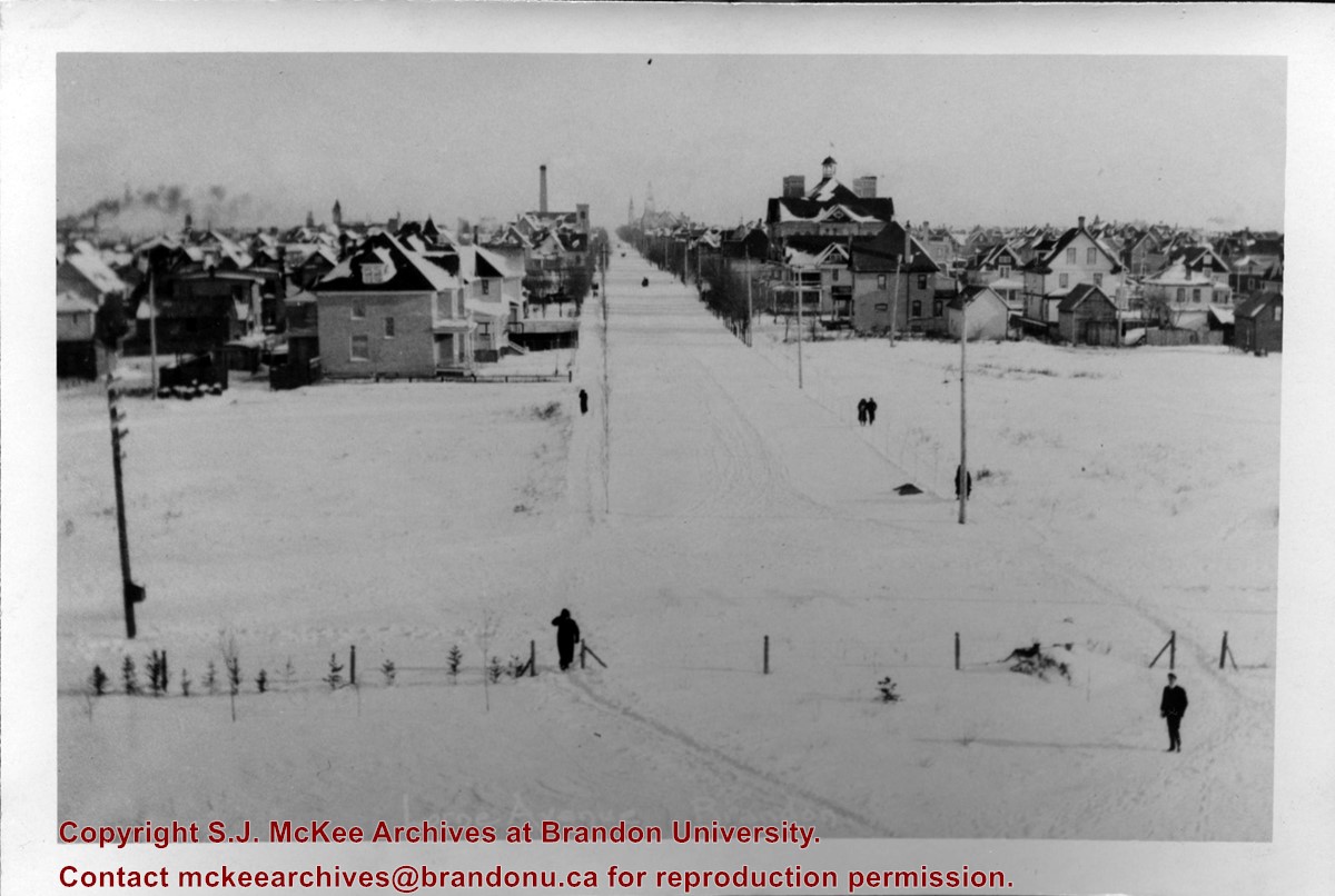
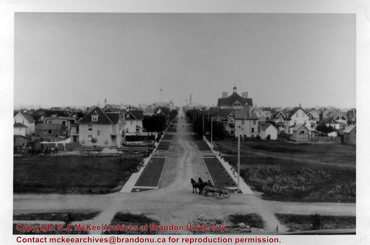
Photograph shows a funeral procession travelling west on Lorne Avenue and turning south onto 18th Street in Brandon. The photograph was taken from Brandon College.
Name Access
Lorne Avenue
18th Street
Park School
Subject Access
cityscapes
funerals
Storage Location
BAPC photograph drawer
Images
Show Less

Aerial view: Brandon College

http://archives.brandonu.ca/en/permalink/descriptions594
Part Of
Brandon University Photograph collection
Description Level
Item
GMD
graphic
Date Range
[fall 1964?]
Part Of
Brandon University Photograph collection
Description Level
Item
Series Number
2.1
Item Number
BUPC 2.1.2
GMD
graphic
Date Range
[fall 1964?]
Physical Description
5" x 4" (b/w)
Scope and Content
Brandon College looking south from 19th Street. Photograph was taken after Flora Cowan Hall was built but before construction of the Education Building.
Subject Access
aerial photographs
campus photographs
campus buildings
Brandon streets
Images
Show Less

Aerial view - Brandon University campus

http://archives.brandonu.ca/en/permalink/descriptions7989
Part Of
Brandon University Photograph collection
Description Level
Item
GMD
graphic
Date Range
c. 2000
Part Of
Brandon University Photograph collection
Creator
Photograph commissioned by Brandon University and taken by Yourview Aerial Scenics Ltd.
Description Level
Item
Series Number
2.1
Item Number
BUPC 2.1.55
GMD
graphic
Date Range
c. 2000
Physical Description
6" x 4" (colour)
Scope and Content
View is southwest from approximatley 16th Street between Princess and Rosser Avenues. Photograph shows the Brandon University campus, as well as surrounding residential blocks, including Flemming, J.R. Reid and Vincent Massey schools.
Subject Access
aerial photographs
campus photographs
campus buildings
Brandon streets
Images
Show Less

Aerial view - Brandon University campus

http://archives.brandonu.ca/en/permalink/descriptions7990
Part Of
Brandon University Photograph collection
Description Level
Item
GMD
graphic
Date Range
c. 2000
Part Of
Brandon University Photograph collection
Creator
Photograph commissioned by Brandon University and taken by Yourview Aerial Scenics Ltd.
Description Level
Item
Series Number
2.1
Item Number
BUPC 2.1.56
GMD
graphic
Date Range
c. 2000
Physical Description
6" x 4" (colour)
Scope and Content
View is west southwest from approximatley 16th Street between Princess and Lorne Avenues. Photograph shows the Brandon University campus, as well as surrounding residential blocks between 16th and 23rd Streets, Princess and Louise Avenues..
Subject Access
aerial photographs
campus photographs
campus buildings
Brandon streets
Images
Show Less

Aerial view - Brandon University campus

http://archives.brandonu.ca/en/permalink/descriptions7991
Part Of
Brandon University Photograph collection
Description Level
Item
GMD
graphic
Date Range
c. 2000
Part Of
Brandon University Photograph collection
Creator
Photograph commissioned by Brandon University and taken by Yourview Aerial Scenics Ltd.
Description Level
Item
Series Number
2.1
Item Number
BUPC 2.1.57
GMD
graphic
Date Range
c. 2000
Physical Description
6" x 4" (colour)
Scope and Content
View is west from approximatley 17th Street between Lorne and Louise Avenues. Photograph shows a portion of the Brandon University campus (excluding the Education Building and anything north of it), as well as surrounding residential blocks from approximatley 17th Street to 22nd Street.
Subject Access
aerial photographs
campus photographs
campus buildings
Brandon streets
Images
Show Less

Aerial view - Brandon University campus

http://archives.brandonu.ca/en/permalink/descriptions7992
Part Of
Brandon University Photograph collection
Description Level
Item
GMD
graphic
Date Range
c. 1990
Part Of
Brandon University Photograph collection
Description Level
Item
Series Number
2.1
Item Number
BUPC 2.1.58
GMD
graphic
Date Range
c. 1990
Physical Description
5" x 3.5" (colour)
Scope and Content
View is west northwest from approximatley 16th Street and Louise Avenue. Photograph shows the Brandon University campus, prior to the Library Extension, and a large portion of the city to the west of the campus.
Subject Access
aerial photographs
campus photographs
campus buildings
Brandon streets
Images
Show Less

Aerial view - Brandon University campus

http://archives.brandonu.ca/en/permalink/descriptions7993
Part Of
Brandon University Photograph collection
Description Level
Item
GMD
graphic
Date Range
c. 1990
Part Of
Brandon University Photograph collection
Description Level
Item
Series Number
2.1
Item Number
BUPC 2.1.59
GMD
graphic
Date Range
c. 1990
Physical Description
5" x 3.5" (colour)
Scope and Content
View is northwest from approximatley 16th Street and Louise Avenue. Photograph shows the Brandon University campus, prior to the Library Extension, and a large portion of the city to the west of the campus.
Subject Access
aerial photographs
campus photographs
campus buildings
Brandon streets
Show Less

Downtown of Brandon - Princess Avenue looking west

http://archives.brandonu.ca/en/permalink/descriptions11702
Part Of
CKX fonds
Description Level
Item
GMD
graphic
Date Range
after 1954
Accession Number
11-2010
Part Of
CKX fonds
Creator
CKX
Description Level
Item
Item Number
11-2010.B139b
Accession Number
11-2010
GMD
graphic
Date Range
after 1954
Physical Description
2.25" x 2.25" (b/w)
Material Details
Negative
Custodial History
See fonds level of the CKX records for custodial history.
Scope and Content
Image of Princess Avenue looking west from 9th Street.
Name Access
CKX Television
Brandon, Manitoba
Subject Access
cityscapes
Storage Location
CKX fonds - 2010 accessions
Images
Show Less

Daly 18th Street overpass

http://archives.brandonu.ca/en/permalink/descriptions10139
Part Of
RG 12 Brandon and Area Photograph Collection
Description Level
Item
GMD
graphic
Date Range
[after 1963]
Part Of
RG 12 Brandon and Area Photograph Collection
Description Level
Item
Series Number
2
Item Number
BAPC 2.27
GMD
graphic
Date Range
[after 1963]
Physical Description
5" x 3.5" (b/w)
History / Biographical
The overpass is named for Brandon's first mayor, Thomas Mayne Daly, and the street on which the overpass is located. The overpass opened in October 1963.
Scope and Content
Photograph is an aerial view of the Daly 18th Street Overpass (18th Street Bridge). Visible are a number of commercial and residential buildings in the north end of Brandon, MB. The view is northeast, probably taken from the roof of the old steam plant north of 20th Street and Rosser Avenue.
Name Access
Daly 18th Street Overpass
18th Street Bridge
Kane Equipment Ltd.
International Harvester Company of Canada
Pacific Avenue
Subject Access
northend
bridges
manmade geographic features
cityscapes
Storage Location
BAPC photograph drawer
Images
Show Less

20 records – page 1 of 1.