Photograph shows the west side of the 200-block on 10th Street. Visible businesses include: Chamber of Commerce Tourist Information, Dominion Tire & Radio Co., Steve's Grill, Wally's Taxi, and the garage entrances to Western Motors Ltd. A Santa Claus Christmas ornament is displayed from a light standard.
Photograph of east side of 10th Street, Brandon, Manitoba, between Rosser and Princess Avenues. Visible businesses include: The Bank of Montreal, Barclay's Shoe Store, Carlton Cafe (in the former Cigar Factory), and Ted Heming Jewellers. The McKenzie Seed building is visible in the background.
Photograph shows the east side of 10th Street, Brandon, Manitoba, between Rosser and Princess Avenues. Businesses visible in the Brown Block include (from north to south): Singer, Pittsburgh Paint & Glass, O. Stark & Son, Elna Sewing Centre, and Canadian Pacific Telegraphs. The Prince Edward Hotel is visible in the background.
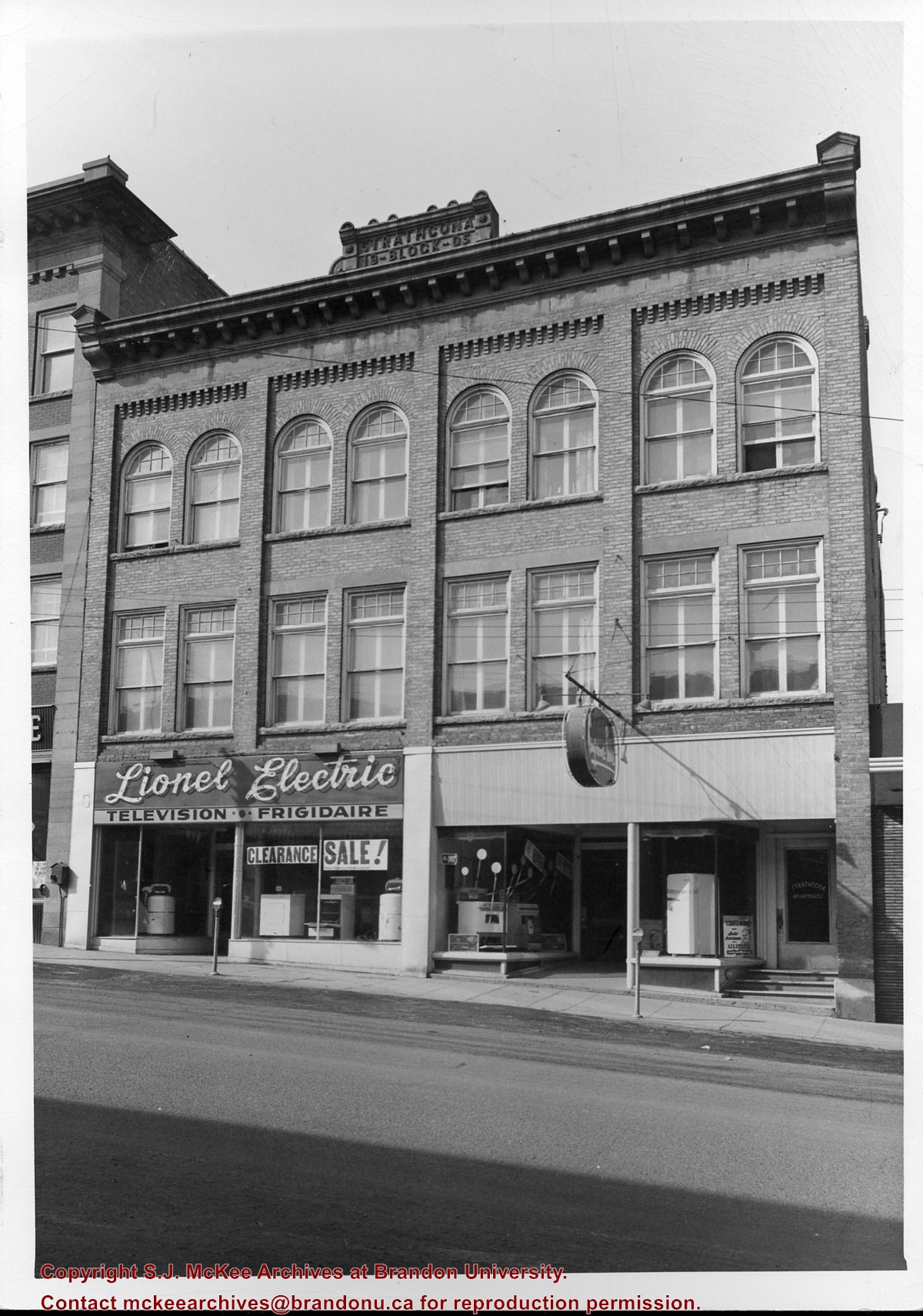
Photograph shows Ted Heming Jewellers on the east side of 10th Street, Brandon, Manitoba, with the Strand Theatre to the south of the building complex. Other visible businesses in the Strand Block include: Hughes & Co. Ltd., Smart's Stationery, Waddell's, and Metropolitan Life.
Notes
Photograph dated from "Gidget," the movie playing at the Strand Theatre
Photograph shows Western Motors Ltd. on the southwest corner of 10th Street and Princess Avenue. To the west of the car dealership/garage is the Greyhound Bus Station and its Maxwell House Cafe as well as the court house.
Photograph shows the Strand Block on the east side of 10th Street, Brandon, Manitoba. Visible businesses in the Strand Block include: Hughes & Co. Ltd., Smart's Stationery, Waddell's, the Strand Theatre, and Metropolitan Life.
Notes
Back of the photograph is stamped: Clark Smith Studio, per July 27/59
Photograph shows the northwest corner of 10th Street and Princess Avenue. Traffic on the west side of Princess Avenue appears to travelling both ways. A taxi waits at the intersection.
Above the west entrance on the corner building is an electric sign that spells "Hughes Bldg." A second storey has been added to the portion of the Doig's shop that is adjacent to the Alexandra Block.
Photograph shows the Greyhound Bus Depot at 11th Street and Princess Avenue. Western Motors, Wheelers Esso Station, and the Prince Edward Hotel are visible along the south side of Princess Avenue. Traffic is travelling one-way on Princess Avenue.
Postcard shows an aerial view of 9th Street facing south in Brandon, Manitoba. Visible businesses and landmarks include: Beaubier Hotel, YMCA/police station, the original CKX Radio station towers on 8th Street (est. 1928 - moved 1940), the old City Hall, Prince Edward Hotel, and the original Manitoba Power commission smokestack on 10th Street.
Notes
Writing on the front of the photograph reads: Brandon, Man., Jerrett Photo. This photograph shows a rare view of the 800-block between Rosser and Princess Avenues.
Red ink stain is on the front right corner of postcard
Scope and Content
Photograph shows 10th Street facing south from Princess Avenue. Visible landmarks and businesses include: Manitoba Power Commission (MPC)'s power sub-station, First Baptist Church, Wheat City Arena, and the grand stand at the Exhibition Grounds.
The partial sign visible at the bottom of the photograph on the east side of 10th Street reads Yates and Neale, which refers to a plumbing and heating company that dissolved in 1943 to be replaced by Neale, Stothard and Chapman.
Businesses on the west side of 10th Street include: Dominion Tire & Radio Co., Bolts Barber Shop, Elviss T.E. Co. Stables.
Notes
Information concerning Yates and Neale courtesy Jack Stothard. Writing on the front of the postcard reads: Brandon, Looking S.W., Jerrett Photo. This photograph shows a rare view of the 200-block of 10th Street.
Photograph shows Western Motors Ltd. on the southwest corner of 10th Street and Princess Avenue. Anglo gas station is part of the car shop, which sells GM, Chevrolet, and Oldsmobiles.
Hutchings' Drugs is on the ground floor of the Hughes Building on the northwest corner of 10th Street and Princess. Manufacturers Life occupies the second storey.
Photograph shows the north face of the Prince Edward Hotel on Princess Avenue. To the east of the hotel is Old City Hall with the military monument (which has since been relocated to the Brandon Armoury). On the west side of the hotel is Wheelers Esso Service Station.
Notes
The photograph appears to be taken from the Hughes Building on 10th Street.
Left hand corner of mat is bent. Mock-up instructions are written in pencil at the bottom right hand corner. Portions of the photograph itself are marked with pen.
History / Biographical
The Queen's Hotel was located on the corner of Rosser Avenue and Tenth Street (Steen & Boyce, 1882. Brandon, Manitoba, Canada and Her Industries. Steen & Boyce Publishers Printers & Binders, 81.). Therefore this photo appears to display Rosser Avenue looking east. P.E. 11/06/09
Scope and Content
Photograph shows early Rosser Avenue under construction between 9th Street and 10th Street in the 1880s. Buildings that line the avenue are wood framed and there are wooden boardwalks in front of a few structures. On the north side of Rosser Avenue signs for Fortier & Bucke Commision Agents and Transit House (Hotel) can be seen. On the south side of Rosser Avenue, the Queen's Hotel and Robinson Brothers and Company groceries and dry goods store are open for business. A family appears to be standing on the stoop at the dry goods store. A boy is lounging in the entryway of the Queen's Hotel. A man is standing on a wooden plank that extends across the dirt road of Rosser Avenue between the dry goods store and the commission agents' shop.
Postcard is of buildings at Brandon University, including Clark Hall and the Original Building prior to the renovations, McMasater Hall, and the Q.E.II School of Music building.
Notes
Writing on the front of the postcard reads: Brandon University. Back of the postcard reads: (Top Left) Brandon University original building (Administration Center.), Bottom Left) Queen Elizabeth II Music Building, (Right) McMaster Hall Residence; Photo by Sandy Black; Printed in Brandon, Manitoba, Canada, by Leech Printing Ltd.
Photograph shows the exterior of the Winter Fair Arena on 10th Street.
Notes
Part of "Souvenir of Brandon, Manitoba, Canada [viewbook], Printed by Photogelatine Engraving Co. Limited, Ottawa." Dates obtained from the Burchill's Music Store Henderson's Brandon City Directory listings (1927-1929). Writing on the front of the photograph reads: Winter Fair Arena, Brandon, Man.
Photograph shows exterior views of five Brandon churches: Baptist Church, Presbyterian Church, St. Matthew's Church, Catholic Church and Monastery, and Methodist Church.
Notes
Part of "Christie's Brandon Series of Six Colored Picture Postcards of Brandon, Manitoba, The Crown Series, Published by Christie's Bookstore, Brandon, Man." [note: missing sixth postcard]. Writing on the front of the photograph reads: Baptist Church, Presbyterian Church Brandon Man., St. Matthew's Church, Catholic Church and Monastery, Methodist Church.
Photograph shows a southwestern view of Clark Hall and the Brandon College Original Building. The Citizen Science Building is absent from the campus grounds.
Notes
Part of "Souvenir of Brandon, Manitoba, Canada [viewbook], Printed by Photogelatine Engraving Co. Limited, Ottawa." Dates obtained from the Burchill's Music Store Henderson's Brandon City Directory listings (1927-1929). Writing on the front of the photograph reads: Brandon College, Brandon, Man.
See fonds level of the CKX records for custodial history.
Scope and Content
Image of the southside of the 1000 and 1100 block of Rosser Avenue looking east in winter. Visible in the foregraound are O.L. Harwood Ltd., and the Key Kafe. Buildings in the 1000 block include: the Imperial Bank of Canada, the original Post Office and Federal Building and the original Merchants Bank. A number of pedestrians are also visible, as are Christmas decorations on the streetlights and telephone poles.


)