Skip header and navigation

Revise Search

20 records – page 2 of 1.

Strand Theatre, Brandon, Manitoba

http://archives.brandonu.ca/en/permalink/descriptions8378
Part Of
Joseph H. Hughes collection
Description Level
Item
GMD
graphic
Date Range
1959
Accession Number
3-1997
Part Of
Joseph H. Hughes collection
Description Level
Item
Series Number
3-1997.1
Item Number
3-1997.1.7
Accession Number
3-1997
GMD
graphic
Date Range
1959
Physical Description
8" x 10" (b/w)
Physical Condition
good
Scope and Content
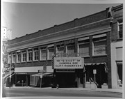
Photograph shows the east side of 10th Street, Brandon, Manitoba. The Strand Theatre marquee shows "Gidget" starring Sandra Dee and Cliff Robertson. Other businesses in the Strand Block include: Ted Heming Jewellers, Waddell's, and Metropolitan Life.
Notes
Photograph dated from "Gidget," the movie playing at the Strand Theatre
Name Access
Strand Theatre
Ted Heming Jewellers
Waddell's
Metropolitan Life
Subject Access
street scenes
Brandon business buildings & facilities after 1940
Storage Location
RG 5 photograph storage drawer
Images
Show Less

Brandon University campus construction

http://archives.brandonu.ca/en/permalink/descriptions8005
Part Of
Brandon University Photograph collection
Description Level
Item
GMD
graphic
Date Range
c. 1996
Part Of
Brandon University Photograph collection
Creator
Photographer: Sandy Black
Description Level
Item
Series Number
2.1
Item Number
BUPC 2.1.71
GMD
graphic
Date Range
c. 1996
Physical Description
4" x 6" (colour)
Scope and Content
View is northeast probably from the roof of McMaster Hall. Photograph shows the construction of the new roof on Clark Hall and the Brandon College Building. A portion of the east side of the 000 and 100 blocks of 18th Street, as well as the corner of 18th Street and Rosser Avenue are visible in the upper left hand corner. This includes the "Downtown Brandon" sign.
Subject Access
campus photographs
campus buildings
campus construction
Brandon streets
Images
Show Less

Brandon University campus construction

http://archives.brandonu.ca/en/permalink/descriptions8006
Part Of
Brandon University Photograph collection
Description Level
Item
GMD
graphic
Date Range
c. 1996
Part Of
Brandon University Photograph collection
Creator
Photographer: Sandy Black
Description Level
Item
Series Number
2.1
Item Number
BUPC 2.1.72
GMD
graphic
Date Range
c. 1996
Physical Description
6" x 4" (colour)
Scope and Content
View is north northeast probably from the roof of McMaster Hall. Photograph shows the construction of the new roof on Clark Hall and the Brandon College Building, as well as the construction of the extension to Clark Hall and the skywalk. Portions of the city as far north as the Assiniboine River are also visible.
Subject Access
campus photographs
campus buildings
campus construction
Brandon streets
Images
Show Less

Brandon University campus construction

http://archives.brandonu.ca/en/permalink/descriptions8018
Part Of
Brandon University Photograph collection
Description Level
Item
GMD
graphic
Date Range
c. 1996
Part Of
Brandon University Photograph collection
Description Level
Item
Series Number
2.1
Item Number
BUPC 2.1.84
GMD
graphic
Date Range
c. 1996
Physical Description
6" x 4" (colour)
Scope and Content
View is north northeast from the roof of McMaster Hall. Photograph shows the campus under construction during the renovation of the Brandon College Building and Clark Hall. The photograph was taken in late fall after the roof had been removed from the buildings but before the construction of the extension of Clark Hall. Construction materials litter the courtyard and driveway. The view looking north extends to The North Hill - a number of residential blocks, particularly to the northeast of 18th Street are visible. Buildings include the International Harvester Building and Kin Village.
Subject Access
campus photographs
campus buildings
campus construction
Brandon streets
Images
Show Less

Brandon University campus construction

http://archives.brandonu.ca/en/permalink/descriptions8020
Part Of
Brandon University Photograph collection
Description Level
Item
GMD
graphic
Date Range
c. 1996
Part Of
Brandon University Photograph collection
Creator
Photographer: Sandy Black
Description Level
Item
Series Number
2.1
Item Number
BUPC 2.1.86
GMD
graphic
Date Range
c. 1996
Physical Description
6" x 4" (colour)
Scope and Content
View is north northeast probably from the roof of McMaster Hall. Photograph shows the construction of the new roof on Clark Hall and the Brandon College Building, as well as the construction of the extension to Clark Hall and the skywalk. The view looking north extends to The North Hill - a number of residential blocks, particularly to the northeast of 18th Street are visible. Buildings include the International Harvester Building and Kin Village.
Subject Access
campus photographs
campus buildings
campus construction
Brandon streets
Images
Show Less

Aerial view: Brandon College

http://archives.brandonu.ca/en/permalink/descriptions594
Part Of
Brandon University Photograph collection
Description Level
Item
GMD
graphic
Date Range
[fall 1964?]
Part Of
Brandon University Photograph collection
Description Level
Item
Series Number
2.1
Item Number
BUPC 2.1.2
GMD
graphic
Date Range
[fall 1964?]
Physical Description
5" x 4" (b/w)
Scope and Content
Brandon College looking south from 19th Street. Photograph was taken after Flora Cowan Hall was built but before construction of the Education Building.
Subject Access
aerial photographs
campus photographs
campus buildings
Brandon streets
Images
Show Less

Aerial view - Brandon University campus

http://archives.brandonu.ca/en/permalink/descriptions7989
Part Of
Brandon University Photograph collection
Description Level
Item
GMD
graphic
Date Range
c. 2000
Part Of
Brandon University Photograph collection
Creator
Photograph commissioned by Brandon University and taken by Yourview Aerial Scenics Ltd.
Description Level
Item
Series Number
2.1
Item Number
BUPC 2.1.55
GMD
graphic
Date Range
c. 2000
Physical Description
6" x 4" (colour)
Scope and Content
View is southwest from approximatley 16th Street between Princess and Rosser Avenues. Photograph shows the Brandon University campus, as well as surrounding residential blocks, including Flemming, J.R. Reid and Vincent Massey schools.
Subject Access
aerial photographs
campus photographs
campus buildings
Brandon streets
Images
Show Less

Aerial view - Brandon University campus

http://archives.brandonu.ca/en/permalink/descriptions7990
Part Of
Brandon University Photograph collection
Description Level
Item
GMD
graphic
Date Range
c. 2000
Part Of
Brandon University Photograph collection
Creator
Photograph commissioned by Brandon University and taken by Yourview Aerial Scenics Ltd.
Description Level
Item
Series Number
2.1
Item Number
BUPC 2.1.56
GMD
graphic
Date Range
c. 2000
Physical Description
6" x 4" (colour)
Scope and Content
View is west southwest from approximatley 16th Street between Princess and Lorne Avenues. Photograph shows the Brandon University campus, as well as surrounding residential blocks between 16th and 23rd Streets, Princess and Louise Avenues..
Subject Access
aerial photographs
campus photographs
campus buildings
Brandon streets
Images
Show Less

Aerial view - Brandon University campus

http://archives.brandonu.ca/en/permalink/descriptions7991
Part Of
Brandon University Photograph collection
Description Level
Item
GMD
graphic
Date Range
c. 2000
Part Of
Brandon University Photograph collection
Creator
Photograph commissioned by Brandon University and taken by Yourview Aerial Scenics Ltd.
Description Level
Item
Series Number
2.1
Item Number
BUPC 2.1.57
GMD
graphic
Date Range
c. 2000
Physical Description
6" x 4" (colour)
Scope and Content
View is west from approximatley 17th Street between Lorne and Louise Avenues. Photograph shows a portion of the Brandon University campus (excluding the Education Building and anything north of it), as well as surrounding residential blocks from approximatley 17th Street to 22nd Street.
Subject Access
aerial photographs
campus photographs
campus buildings
Brandon streets
Images
Show Less

Aerial view - Brandon University campus

http://archives.brandonu.ca/en/permalink/descriptions7992
Part Of
Brandon University Photograph collection
Description Level
Item
GMD
graphic
Date Range
c. 1990
Part Of
Brandon University Photograph collection
Description Level
Item
Series Number
2.1
Item Number
BUPC 2.1.58
GMD
graphic
Date Range
c. 1990
Physical Description
5" x 3.5" (colour)
Scope and Content
View is west northwest from approximatley 16th Street and Louise Avenue. Photograph shows the Brandon University campus, prior to the Library Extension, and a large portion of the city to the west of the campus.
Subject Access
aerial photographs
campus photographs
campus buildings
Brandon streets
Images
Show Less

Aerial view - Brandon University campus

http://archives.brandonu.ca/en/permalink/descriptions7993
Part Of
Brandon University Photograph collection
Description Level
Item
GMD
graphic
Date Range
c. 1990
Part Of
Brandon University Photograph collection
Description Level
Item
Series Number
2.1
Item Number
BUPC 2.1.59
GMD
graphic
Date Range
c. 1990
Physical Description
5" x 3.5" (colour)
Scope and Content
View is northwest from approximatley 16th Street and Louise Avenue. Photograph shows the Brandon University campus, prior to the Library Extension, and a large portion of the city to the west of the campus.
Subject Access
aerial photographs
campus photographs
campus buildings
Brandon streets
Show Less

Aerial view - Brandon College looking southwest

http://archives.brandonu.ca/en/permalink/descriptions601
Part Of
Brandon University Photograph collection
Description Level
Item
GMD
graphic
Date Range
[1963-1966]
Part Of
Brandon University Photograph collection
Description Level
Item
Series Number
2.1
Item Number
BUPC 2.1.8
GMD
graphic
Date Range
[1963-1966]
Physical Description
5" x 4" (b/w)
Scope and Content
Image shows the Brandon College campus from 17th Street looking southwest. The photo was taken after the completion of the original Music Building in 1963, but construction of the Education Building. Also visible are a number of properties on the 200 block of 18th Street and the 200 block of 20th Street.
Subject Access
aerial photographs
campus photographs
campus buildings
Brandon streets
Images
Show Less

Carlton Cafe, Brandon, Manitoba

http://archives.brandonu.ca/en/permalink/descriptions8382
Part Of
Joseph H. Hughes collection
Description Level
Item
GMD
graphic
Date Range
c. 1959
Accession Number
3-1997
Part Of
Joseph H. Hughes collection
Description Level
Item
Series Number
3-1997.1
Item Number
3-1997.1.10
Accession Number
3-1997
GMD
graphic
Date Range
c. 1959
Physical Description
8" x 10" (b/w)
Physical Condition
good
Scope and Content
Photograph of east side of 10th Street, Brandon, Manitoba, between Rosser and Princess Avenues. Visible businesses include: The Bank of Montreal, Barclay's Shoe Store, Carlton Cafe (in the former Cigar Factory), and Ted Heming Jewellers. The McKenzie Seed building is visible in the background.
Name Access
Bank of Montreal
Barclay's Shoe Store
Carlton Cafe
Ted Heming Jewellers
McKenzie Seeds
10th Street
Subject Access
downtowns
street scenes
Brandon business buildings & facilities after 1940
building exteriors
Storage Location
RG 5 photograph storage drawer
Images
Show Less

The Brown Block, Brandon, Manitoba

http://archives.brandonu.ca/en/permalink/descriptions8383
Part Of
Joseph H. Hughes collection
Description Level
Item
GMD
graphic
Date Range
c. 1959
Accession Number
3-1997
Part Of
Joseph H. Hughes collection
Description Level
Item
Series Number
3-1997.1
Item Number
3-1997.1.11
Accession Number
3-1997
GMD
graphic
Date Range
c. 1959
Physical Description
8 " x 10" (b/w)
Physical Condition
good
Scope and Content
Photograph shows the east side of 10th Street, Brandon, Manitoba, between Rosser and Princess Avenues. Businesses visible in the Brown Block include (from north to south): Singer, Pittsburgh Paint & Glass, O. Stark & Son, Elna Sewing Centre, and Canadian Pacific Telegraphs. The Prince Edward Hotel is visible in the background.
Name Access
Brown Block
Singer
Pittsburgh Paint & Glass
O. Stark & Son
Elna Sewing Centre
Canadian Pacific Telegraphs
Prince Edward Hotel
10th Street
Subject Access
downtowns
street scenes
Brandon business buildings & facilities after 1940
building exteriors
Storage Location
RG 5 photograph storage drawer
Images
Show Less

Strathcona Block, Brandon, Manitoba

http://archives.brandonu.ca/en/permalink/descriptions8410
Part Of
Joseph H. Hughes collection
Description Level
Item
GMD
graphic
Date Range
c.1950
Accession Number
3-1997
Part Of
Joseph H. Hughes collection
Creator
Photographer: R.M. Coleman
Description Level
Item
Series Number
3-1997.1
Item Number
3-1997.1.32
Accession Number
3-1997
GMD
graphic
Date Range
c.1950
Physical Description
5" x 7" (b/w)
Physical Condition
good
Scope and Content
Photograph shows the Strathcona Block on the west side of 10th Street in the 100-block. Simpsons-Sears and Lionel Electric are the ground floor shops.
Name Access
Strathcona Block
Simpsons-Sears Ltd.
Lionel Electric
Subject Access
downtowns
street scenes
Brandon business buildings & facilities after 1940
building exteriors
Storage Location
RG 5 photograph storage drawer
Images
Show Less

Hughes Building, Brandon, Manitoba

http://archives.brandonu.ca/en/permalink/descriptions8403
Part Of
Joseph H. Hughes collection
Description Level
Item
GMD
graphic
Date Range
c. 1955
Accession Number
3-1997
Part Of
Joseph H. Hughes collection
Description Level
Item
Series Number
3-1997.1
Item Number
3-1997.1.25
Accession Number
3-1997
GMD
graphic
Date Range
c. 1955
Physical Description
4.5" x 6.75" (b/w)
Physical Condition
good
Scope and Content
Photograph shows the northwest corner of 10th Street and Princess Avenue. Traffic on the west side of Princess Avenue appears to travelling both ways. A taxi waits at the intersection. Above the west entrance on the corner building is an electric sign that spells "Hughes Bldg." A second storey has been added to the portion of the Doig's shop that is adjacent to the Alexandra Block.
Notes
A negative accompanies the photograph.
Name Access
Doig's
Hughes Building
Alexandra Block
Princess Avenue
10th Street
Subject Access
downtowns
street scenes
Brandon business buildings & facilities after 1940
building exteriors
taxi
Storage Location
RG 5 photograph storage drawer
Images
Show Less

Hughes family in Ontario

http://archives.brandonu.ca/en/permalink/descriptions14266
Part Of
Joseph H. Hughes collection
Description Level
Item
GMD
graphic
Date Range
1868
Accession Number
3-1997
Part Of
Joseph H. Hughes collection
Description Level
Item
Series Number
3-1997.1
Item Number
3-1997.1.68
Accession Number
3-1997
Other Numbers
Hughes #66
GMD
graphic
Date Range
1868
Physical Description
9.25" x 7.25" (b/w)
Material Details
on matting
Scope and Content
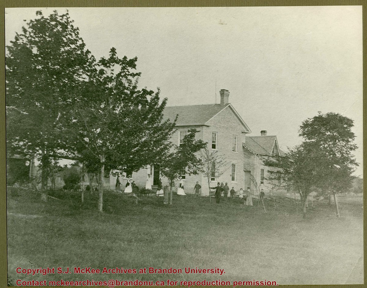
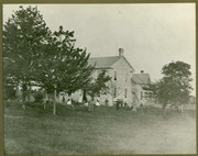
Photograph shows a group of 14 individuals scattered throughout a yard of a two-storey brick home with an extension. An elderly woman can be seen a wheelchair. Four women are wearing white gowns with long sleeves.
Notes
Writing on the front corner of the photograph reads: 1868
Subject Access
portraits
residences
building exteriors
Storage Location
Hughes oversize drawer
Images
Show Less

Ted Heming Jewellers, Brandon, Manitoba

http://archives.brandonu.ca/en/permalink/descriptions8379
Part Of
Joseph H. Hughes collection
Description Level
Item
GMD
graphic
Date Range
1959
Accession Number
3-1997
Part Of
Joseph H. Hughes collection
Description Level
Item
Series Number
3-1997.1
Item Number
3-1997.1.8
Accession Number
3-1997
GMD
graphic
Date Range
1959
Physical Description
8" x 10" (b/w)
Physical Condition
good
Scope and Content
Photograph shows Ted Heming Jewellers on the east side of 10th Street, Brandon, Manitoba, with the Strand Theatre to the south of the building complex. Other visible businesses in the Strand Block include: Hughes & Co. Ltd., Smart's Stationery, Waddell's, and Metropolitan Life.
Notes
Photograph dated from "Gidget," the movie playing at the Strand Theatre
Name Access
Ted Heming Jewellers
Hughes & Co.
Smart's Stationery
Waddell's
Strand Theatre
Metropolitan Life
10th Street
Subject Access
downtowns
street scenes
Brandon business buildings & facilities after 1940
building exteriors
Storage Location
RG 5 photograph storage drawer
Images
Show Less

Aerial view of 10th Street facing south from Princess Avenue

http://archives.brandonu.ca/en/permalink/descriptions8420
Part Of
Joseph H. Hughes collection
Description Level
Item
GMD
graphic
Date Range
c.1940
Accession Number
3-1997
Part Of
Joseph H. Hughes collection
Creator
Photographer: Jerrett Photo
Description Level
Item
Series Number
3-1997.1
Item Number
3-1997.1.42
Accession Number
3-1997
GMD
graphic
Date Range
c.1940
Physical Description
5.5" x 3.5" (b/w)
Material Details
postcard
Physical Condition
Red ink stain is on the front right corner of postcard
Scope and Content
Photograph shows 10th Street facing south from Princess Avenue. Visible landmarks and businesses include: Manitoba Power Commission (MPC)'s power sub-station, First Baptist Church, Wheat City Arena, and the grand stand at the Exhibition Grounds. The partial sign visible at the bottom of the photograph on the east side of 10th Street reads Yates and Neale, which refers to a plumbing and heating company that dissolved in 1943 to be replaced by Neale, Stothard and Chapman. Businesses on the west side of 10th Street include: Dominion Tire & Radio Co., Bolts Barber Shop, Elviss T.E. Co. Stables.
Notes
Information concerning Yates and Neale courtesy Jack Stothard. Writing on the front of the postcard reads: Brandon, Looking S.W., Jerrett Photo. This photograph shows a rare view of the 200-block of 10th Street.
Name Access
Manitoba Power Company
10th Street
Dominion Tire & Radio Co.
T.E. Elviss Co. Stables
First Baptist Church
Subject Access
downtowns
street scenes
Brandon business buildings & facilities before 1940
aerial views
building exteriors
residences
churches
Storage Location
RG 5 photograph storage drawer
Images
Show Less

Corner of 10th Street and Princess, Brandon, Manitoba

http://archives.brandonu.ca/en/permalink/descriptions8388
Part Of
Joseph H. Hughes collection
Description Level
Item
GMD
graphic
Date Range
c. 1950
Accession Number
3-1997
Part Of
Joseph H. Hughes collection
Description Level
Item
Series Number
3-1997.1
Item Number
3-1997.1.15
Accession Number
3-1997
GMD
graphic
Date Range
c. 1950
Physical Description
8 " x 10" (b/w)
Physical Condition
good
Scope and Content
Photograph shows the intersection, facing northwest, at 10th Street and Princess Avenue, Brandon, Manitoba. Fitwell Tailors can be seen on the south side of Princess Avenue. Doig's Home Furnishings and The Manufactuerers Life can be seen on the northwest corner. Traffic appears to be travelling both ways on Princess Avenue.
Name Access
Fitwell Tailors
Doig's
Manufacturers Life
Subject Access
downtowns
street scenes
Brandon business buildings & facilities after 1940
building exteriors
Storage Location
RG 5 photograph storage drawer
Images
Show Less

20 records – page 2 of 1.