Skip header and navigation

Revise Search

20 records – page 1 of 1.

Aerial view: Brandon College looking northwest

http://archives.brandonu.ca/en/permalink/descriptions599
Part Of
Aerial views and campus photographs
Description Level
Item
GMD
graphic
Date Range
late 1960s
Part Of
Aerial views and campus photographs
Description Level
Item
Series Number
2.1
Item Number
2.1.7
GMD
graphic
Date Range
late 1960s
Physical Description
5" x 4" (b/w)
Scope and Content
Brandon College. Looking north west over the valley after 1963 Music Building opening, but before trees were moved to the quadrangle.
Images
Show Less

Aerial view: Brandon College campus looking northwest

http://archives.brandonu.ca/en/permalink/descriptions616
Part Of
Aerial views and campus photographs
Description Level
Item
GMD
graphic
Date Range
c. 1963
Part Of
Aerial views and campus photographs
Description Level
Item
Series Number
2.1
Item Number
2.1.24
GMD
graphic
Date Range
c. 1963
Physical Description
5" x 4" (b/w)
Scope and Content
View is northwest from approximately the corner of 18th Street and Louise Avenue. Photograph shows the Brandon College campus after the completion of Flora Cowan Hall.
Notes
BUPC 2.1.20 is a larger version of this photograph.
Images
Show Less

Brandon University driveway

http://archives.brandonu.ca/en/permalink/descriptions841
Part Of
Aerial views and campus photographs
Description Level
Item
GMD
graphic
Date Range
c. 1980s
Part Of
Aerial views and campus photographs
Description Level
Item
Series Number
2.1
Item Number
2.1.35
GMD
graphic
Date Range
c. 1980s
Physical Description
3.5" x 5" (b/w)
Scope and Content
View is north from approximately the Citizens' Science Building. Photograph shows the driveway running in front of the Brandon College Building and Clark Hall, a number of cars and students along the driveway and the Education Building in the background.
Images
Show Less

Brandon College north driveway entrance

http://archives.brandonu.ca/en/permalink/descriptions8070
Part Of
Aerial views and campus photographs
Description Level
Item
GMD
graphic
Date Range
c. 1964
Part Of
Aerial views and campus photographs
Description Level
Item
Series Number
2.1
Item Number
2.1.139
GMD
graphic
Date Range
c. 1964
Physical Description
10" x 8" (b/w)
Scope and Content
View is southwest from the north side of Princess Avenue. Photograph shows the north driveway entrance on campus. The original Music Building, the A.E. McKenzie Building, Clark Hall and part of the Brandon College Building are visible.
Images
Show Less

Driveway to old barn near Cameron School

http://archives.brandonu.ca/en/permalink/descriptions10731
Part Of
RG 11 Lawrence Stuckey fonds
Description Level
Item
GMD
graphic
Date Range
January 29, 1979
Accession Number
1-2002
Part Of
RG 11 Lawrence Stuckey fonds
Creator
L.A. Stuckey
Description Level
Item
Series Number
3.3
Item Number
1-2002.3.3.BNW[273]
Accession Number
1-2002
GMD
graphic
Date Range
January 29, 1979
Physical Description
2.25" x 2.25" (b/w)
Material Details
Negative
History / Biographical
Stuckey's notes: James M. Grant. Lonely Prairie File.
Custodial History
For custodial history see the collection level description of the Lawrence Stuckey collection.
Scope and Content
Image of driveway to old barn near Cameron School, north of Minnedosa, Manitoba.
Notes
[Brandon NW includes communities north of Trans-Canada #1 highway and west of PTH #10.]
Name Access
Minnedosa, Manitoba
Subject Access
school buildings
Repro Restriction
The McKee Archives is the copyright holder of the Stuckey materials.
Storage Location
Lawrence Stuckey collection
Images
Show Less

Rosser Avenue Looking East

http://archives.brandonu.ca/en/permalink/descriptions9191
Part Of
RG 11 Lawrence Stuckey fonds
Description Level
Item
GMD
graphic
Date Range
[ca. 1905]
Accession Number
1-2002
Part Of
RG 11 Lawrence Stuckey fonds
Description Level
Item
Series Number
3.1
Item Number
1-2002.3.1C4
Accession Number
1-2002
GMD
graphic
Date Range
[ca. 1905]
Physical Description
3 1/2" x 5"
Material Details
Negative
History / Biographical
The Strome & White Co. General Store (L. foreground; built 1902) became Brandon Hardware & Brandon Hardware block, later Ashdowns; The final tenant was Stylerite Hardware with two floors of residential suites. It was destroyed by fire March 27, 1983
Custodial History
For custodial history see the collection level description of the Lawrence Stuckey collection.
Scope and Content
View of Rosser Avenue, looking east from Seventh Street
Name Access
Rosser Avenue Looking East
Subject Access
downtowns
businesses
Brandon Street Scenes Before 1940
Repro Restriction
The McKee Archives is the copyright holder for the Stuckey materials.
Storage Location
Lawrence Stuckey collection
Images
Show Less

Rosser Avenue Looking West

http://archives.brandonu.ca/en/permalink/descriptions9192
Part Of
RG 11 Lawrence Stuckey fonds
Description Level
Item
GMD
graphic
Date Range
[ca. 1905]
Accession Number
1-2002
Part Of
RG 11 Lawrence Stuckey fonds
Description Level
Item
Series Number
3.1
Item Number
1-2002.3.1C4a
Accession Number
1-2002
GMD
graphic
Date Range
[ca. 1905]
Physical Description
2 1/2" x 3 1/2"
Material Details
Negative
Custodial History
For custodial history see the collection level description of the Lawrence Stuckey collection.
Scope and Content
View of Rosser Avenue, looking west from Seventh Street
Name Access
Rosser Avenue Looking West
Subject Access
downtowns
businesses
Brandon Street Scenes Before 1940
Repro Restriction
The McKee Archives is the copyright holder for the Stuckey materials.
Storage Location
Lawrence Stuckey collection
Images
Show Less

Ninth Street Looking South

http://archives.brandonu.ca/en/permalink/descriptions9210
Part Of
RG 11 Lawrence Stuckey fonds
Description Level
Item
GMD
graphic
Date Range
1911
Accession Number
1-2002
Part Of
RG 11 Lawrence Stuckey fonds
Creator
I.C. Barton (Chicago)
Description Level
Item
Series Number
3.1
Item Number
1-2002.3.1C22
Accession Number
1-2002
GMD
graphic
Date Range
1911
Physical Description
3 1/2" x 5"
Material Details
Negative
Custodial History
For custodial history see the collection level description of the Lawrence Stuckey collection.
Scope and Content
View of Ninth Street south from Christie Building
Notes
Shows: St. Paul's Church, Old City Hall, Prince Edward Hotel under construction
Name Access
Ninth Street Looking South
Subject Access
downtowns
businesses
hotels
city halls
churches
Brandon Street Scenes Before 1940
Repro Restriction
The McKee Archives is the copyright holder for the Stuckey materials.
Storage Location
Lawrence Stuckey collection
Images
Show Less

Aerial view: Brandon College looking west

http://archives.brandonu.ca/en/permalink/descriptions595
Part Of
Aerial views and campus photographs
Description Level
Item
GMD
graphic
Date Range
c. spring 1963
Part Of
Aerial views and campus photographs
Description Level
Item
Series Number
2.1
Item Number
2.1.3
GMD
graphic
Date Range
c. spring 1963
Physical Description
10" x 8" (b/w)
Scope and Content
View is west to McDiarmid Drive from approximately 16th Street between Princess and Louise Avenues. Photograph shows: Brandon College, Fleming School, Coronation Park, and West End Community Centre.
Images
Show Less

Aerial view: Brandon College looking east

http://archives.brandonu.ca/en/permalink/descriptions617
Part Of
Aerial views and campus photographs
Description Level
Item
GMD
graphic
Date Range
c. 1963
Part Of
Aerial views and campus photographs
Description Level
Item
Series Number
2.1
Item Number
2.1.25
GMD
graphic
Date Range
c. 1963
Physical Description
5" x 4" (b/w)
Scope and Content
View is east from approximatley 22nd Street between Lorne and Louise Avenues. Photograph shows: Darrach Hall, Flora Cowan Hall and the Citizens' Science Building, as well as a number of homes in the area.
Images
Show Less

Downtown of Brandon - 10th Street looking north

http://archives.brandonu.ca/en/permalink/descriptions11701
Part Of
CKX fonds
Description Level
Item
GMD
graphic
Date Range
after 1954
Accession Number
11-2010
Part Of
CKX fonds
Creator
CKX
Description Level
Item
Item Number
11-2010.B139a
Accession Number
11-2010
GMD
graphic
Date Range
after 1954
Physical Description
2.25" x 2.25" (b/w)
Material Details
Negative
Custodial History
See fonds level of the CKX records for custodial history.
Scope and Content
Image of 10th Street looking north from Princess Avenue.
Name Access
CKX Television
Brandon, Manitoba
Subject Access
cityscapes
Storage Location
CKX fonds - 2010 accessions
Images
Show Less

Downtown of Brandon - Princess Avenue looking west

http://archives.brandonu.ca/en/permalink/descriptions11702
Part Of
CKX fonds
Description Level
Item
GMD
graphic
Date Range
after 1954
Accession Number
11-2010
Part Of
CKX fonds
Creator
CKX
Description Level
Item
Item Number
11-2010.B139b
Accession Number
11-2010
GMD
graphic
Date Range
after 1954
Physical Description
2.25" x 2.25" (b/w)
Material Details
Negative
Custodial History
See fonds level of the CKX records for custodial history.
Scope and Content
Image of Princess Avenue looking west from 9th Street.
Name Access
CKX Television
Brandon, Manitoba
Subject Access
cityscapes
Storage Location
CKX fonds - 2010 accessions
Images
Show Less

Downtown of Brandon - Rosser Avenue looking east

http://archives.brandonu.ca/en/permalink/descriptions11703
Part Of
CKX fonds
Description Level
Item
GMD
graphic
Date Range
after 1954
Accession Number
11-2010
Part Of
CKX fonds
Creator
CKX
Description Level
Item
Item Number
11-2010.B139c
Accession Number
11-2010
GMD
graphic
Date Range
after 1954
Physical Description
2.25" x 2.25" (b/w)
Material Details
Negative
Custodial History
See fonds level of the CKX records for custodial history.
Scope and Content
Image of Rosser Avenue looking east from 11th Street.
Name Access
CKX Television
Brandon, Manitoba
Subject Access
cityscapes
Storage Location
CKX fonds - 2010 accessions
Images
Show Less

CPR station looking west from overhead bridge

http://archives.brandonu.ca/en/permalink/descriptions8778
Part Of
RG 11 Lawrence Stuckey fonds
Description Level
Item
GMD
graphic
Date Range
1908
Accession Number
1-2002
Part Of
RG 11 Lawrence Stuckey fonds
Creator
Frank Gowen
Description Level
Item
Series Number
3.9
Item Number
1-2002.3.9.153
Accession Number
1-2002
GMD
graphic
Date Range
1908
Physical Description
7.5" x 4.5" (b/w)
History / Biographical
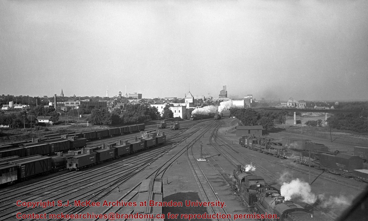
Stuckey's notes: Date determination: Engine 93, ex 375 received Series 2 numbering Sept. 1907 and repainting is still clean; some trees have leaves so could be Sept. 1907 but more likely about May 1908.
Scope and Content
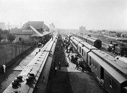
Photograph is looking west along the CPR tracks. Trains at the station have both freight and passenger cars - freight and baggage is being loaded, while people are both arriving and departing.
Notes
Corresponds with negative 1-2002.3.9.P8.
Repro Restriction
The McKee Archives is the copyright holder for the Stuckey materials.
Location Original
1-2002.3.1P8
Storage Location
RG 5 photograph storage drawer
Images
Show Less

CPR yards, looking west from coal dock

http://archives.brandonu.ca/en/permalink/descriptions8785
Part Of
RG 11 Lawrence Stuckey fonds
Description Level
Item
GMD
graphic
Date Range
September 1938
Accession Number
1-2002
Part Of
RG 11 Lawrence Stuckey fonds
Creator
Photographer: George H. Harris
Description Level
Item
Series Number
3.9
Item Number
1-2002.3.9.160
Accession Number
1-2002
GMD
graphic
Date Range
September 1938
Physical Description
9.5" x 6.5" (b/w)
History / Biographical
Stuckey's notes: No. 54 Moose Jaw - Winnipeg Local is leaving (just E. of 1st St. Bridge). Original negative. Collection of George H. Harris, Winnipeg, Man
Scope and Content
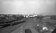
Photograph is looking west southwest along the CPR tracks.
Notes
Corresponds with negative 1-2002.3.9.P16.
Repro Restriction
The McKee Archives is the copyright holder for the Stuckey materials.
Location Original
1-2002.3.1P16
Storage Location
RG 5 photograph storage drawer
Images
Show Less

Granaries, northwest of Douglas

http://archives.brandonu.ca/en/permalink/descriptions10914
Part Of
RG 11 Lawrence Stuckey fonds
Description Level
Item
GMD
graphic
Date Range
July 24, 1977
Accession Number
1-2002
Part Of
RG 11 Lawrence Stuckey fonds
Creator
L.A. Stuckey
Description Level
Item
Series Number
3.3
Item Number
1-2002.3.3.BNE[322]
Accession Number
1-2002
GMD
graphic
Date Range
July 24, 1977
Physical Description
2.25" x 2.25" (b/w)
Material Details
Negative
Custodial History
For custodial history see the collection level description of the Lawrence Stuckey collection.
Scope and Content
Image of granaries, northwest of Douglas.
Notes
[Brandon NE includes communities north of Trans-Canada #1 highway and east of PTH #10.]
Name Access
Douglas, Manitoba
Subject Access
granaries
Repro Restriction
The McKee Archives is the copyright holder of the Stuckey materials.
Storage Location
Lawrence Stuckey collection
Images
Show Less

Brandon streets - Rosser Avenue looking east from the 1100 block

http://archives.brandonu.ca/en/permalink/descriptions11554
Part Of
CKX fonds
Description Level
Item
GMD
graphic
Date Range
after 1954
Accession Number
11-2010
Part Of
CKX fonds
Creator
CKX
Description Level
Item
Item Number
11-2010.B103c
Accession Number
11-2010
GMD
graphic
Date Range
after 1954
Physical Description
5" x 4" (b/w)
Material Details
Negative
Custodial History
See fonds level of the CKX records for custodial history.
Scope and Content
Image of Rosser Avenue looking east from the 1100 block.
Name Access
CKX
Brandon, Manitoba
Subject Access
steetscapes
Storage Location
CKX fonds - 2010 accessions
Images
Show Less

Brandon streets - 9th Street looking north from Princess Avenue

http://archives.brandonu.ca/en/permalink/descriptions11555
Part Of
CKX fonds
Description Level
Item
GMD
graphic
Date Range
after 1954
Accession Number
11-2010
Part Of
CKX fonds
Creator
CKX
Description Level
Item
Item Number
11-2010.B103d
Accession Number
11-2010
GMD
graphic
Date Range
after 1954
Physical Description
5" x 4" (b/w)
Material Details
Negative
Custodial History
See fonds level of the CKX records for custodial history.
Scope and Content
Image of 9th Street looking north from Princess Avenue.
Name Access
CKX
Brandon, Manitoba
Subject Access
steetscapes
Storage Location
CKX fonds - 2010 accessions
Images
Show Less

Brandon streets - Princess Avenue looking east from 10th Street

http://archives.brandonu.ca/en/permalink/descriptions11556
Part Of
CKX fonds
Description Level
Item
GMD
graphic
Date Range
after 1954
Accession Number
11-2010
Part Of
CKX fonds
Creator
CKX
Description Level
Item
Item Number
11-2010.B103e
Accession Number
11-2010
GMD
graphic
Date Range
after 1954
Physical Description
5" x 4" (b/w)
Material Details
Negative
Custodial History
See fonds level of the CKX records for custodial history.
Scope and Content
Image of Princess Avenue looking east from 10th Street.
Name Access
CKX
Brandon, Manitoba
Subject Access
steetscapes
Storage Location
CKX fonds - 2010 accessions
Images
Show Less

Brandon streets - 10th Street looking north from Princess Avenue

http://archives.brandonu.ca/en/permalink/descriptions11558
Part Of
CKX fonds
Description Level
Item
GMD
graphic
Date Range
after 1954
Accession Number
11-2010
Part Of
CKX fonds
Creator
CKX
Description Level
Item
Item Number
11-2010.B103g
Accession Number
11-2010
GMD
graphic
Date Range
after 1954
Physical Description
5" x 4" (b/w)
Material Details
Negative
Custodial History
See fonds level of the CKX records for custodial history.
Scope and Content
Image of 10th Street looking north from Princess Avenue.
Name Access
CKX
Brandon, Manitoba
Subject Access
steetscapes
Storage Location
CKX fonds - 2010 accessions
Images
Show Less

20 records – page 1 of 1.