Skip header and navigation

Revise Search

20 records – page 1 of 1.

Part Of
Fred McGuinness collection
Description Level
Item
GMD
graphic
Date Range
[19--]
Accession Number
20-2009
Part Of
Fred McGuinness collection
Description Level
Item
Series Number
McG 9
Item Number
20-2009.172
Accession Number
20-2009
GMD
graphic
Date Range
[19--]
Physical Description
5" x 7" (b/w)
Material Details
reproduction
History / Biographical
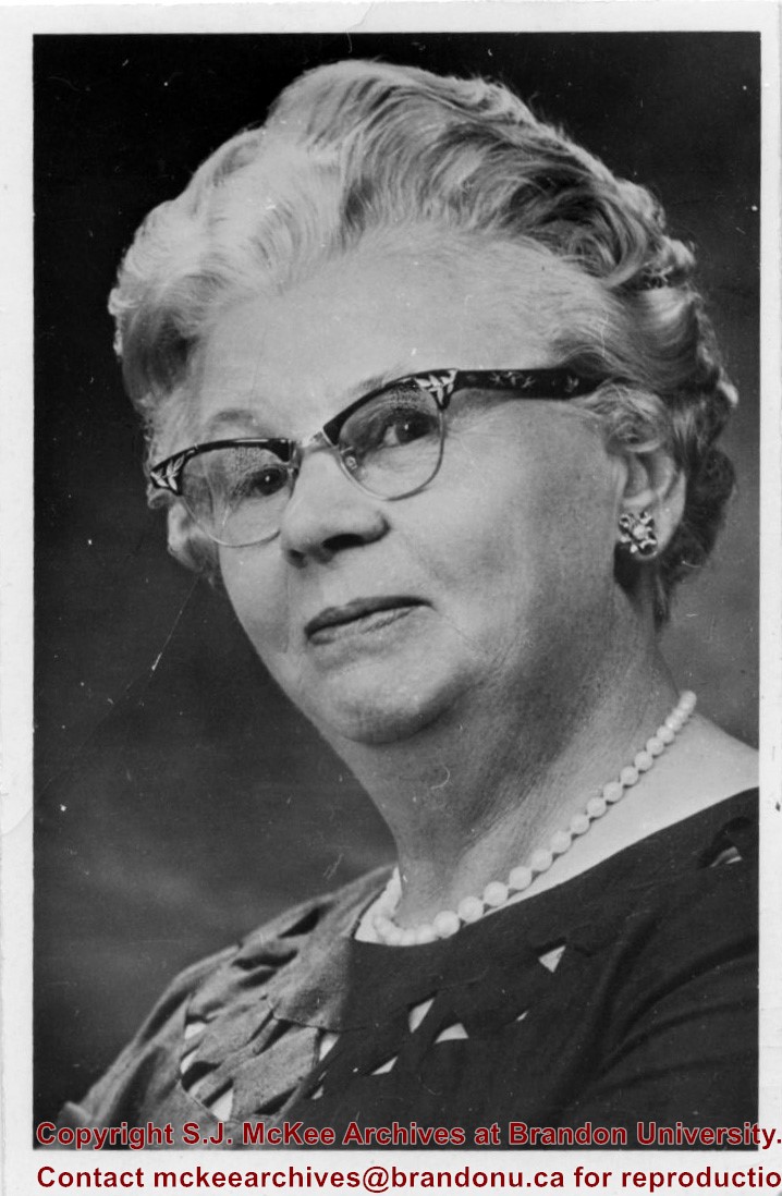
Mrs. Flora Cowan (1902-1986) was born on July 15, 1902 in Edinburgh, Scotland. She was the daughter of Adam and Helen Cruickshank and immigrated to Brandon with her parents in 1927. She married E.C. Cowan, and they had two children, Franklin and Ruth. From 1953 until Brandon College became Brandon University, she served as the Dean of Women. In 1966 she received the Good Citizenship Award of the Golden Boys of Manitoba. She was a member of the I.O.D.E. and a life-member of the International Peace Garden, and the Provincial Council of Women. From 1954 to 1970 Mrs. Cowan served as a member of the Brandon City Council and was the first woman to be appointed acting mayor. She was also the Chairman of the Board for Fairview Home, Inc. In 1967, Mrs. Cowan received the Trillium Business and Professional Club Woman of the Year Award. She was also a member of several other community committees. The women's residence at Brandon University, Flora Cowan, is named in her honour. In December 1980, Mrs. Cowan finally retired from her many positions. She died in Brandon on September 25, 1986 at the age of 84.
Scope and Content
Photograph is a portrait of Flora Cowan
Name Access
Flora Cowan
Subject Access
portraits
Storage Location
RG 5 photograph storage drawer 2 (hanging photos)
Related Material
Trillium Business and Professional Women’s Club records
Arrangement
From 2009 loose photos, from File 13
Images
Show Less

Aerial view: Clark Hall, Education Building, Student Union Building

http://archives.brandonu.ca/en/permalink/descriptions612
Part Of
Aerial views and campus photographs
Description Level
Item
GMD
graphic
Date Range
c. 1960s
Part Of
Aerial views and campus photographs
Description Level
Item
Series Number
2.1
Item Number
2.1.17
GMD
graphic
Date Range
c. 1960s
Physical Description
10" x 8" (b/w)
Scope and Content
View is northeast, taken from the John R. Brodie Science Centre. Photograph shows: the Brandon College Building, the Student Services H-Hut, the Education Building, and the Student Union Building (Citizens' Science Building), as well as 18th Street and some houses. The trailer to the south of the Education Building was a Canada Manpower office in the 1960s. It was latter moved over by the Gymnasium, where it became the Quill office.
Images
Show Less

Aerial view of Brandon postcard

http://archives.brandonu.ca/en/permalink/descriptions13867
Part Of
Fred McGuinness collection
Description Level
Item
GMD
graphic
Date Range
1970
Accession Number
20-2009
Part Of
Fred McGuinness collection
Creator
Photographer: R.J. "Bob" Snazel
Description Level
Item
Series Number
McG 9
Item Number
20-2009.177
Accession Number
20-2009
GMD
graphic
Date Range
1970
Physical Description
3.5" x 6" (colour)
Material Details
postcard
Scope and Content
Postcard shows an aerial view of the city of Brandon
Notes
Writing on the back of the postcard reads: No. 10. Brandon, Manitoba, Canada / Aerial View of Brandon / Distributed by Clements Drug Store / Brandon, Manitoba, Canada / Photos by: R.J. "Bob" Snazel. / Printed by: D.W. Friesen & Sons Ltd. Altona, Manitoba, Canada. The postcard is addressed to Mr. F.A. Rosser and is postmarked Brandon 30 May 1970. A 6-cent Queen Elizabeth red postage stamp portraying various modes of the transportation. The stamp has been cancelled with a postmark that reads "Help Retarded Children."
Name Access
City of Brandon
Subject Access
aerial photographs
aerial views
Repro Restriction
Canadian Copyright restrictions apply. Consult the Archivist.
Storage Location
RG 5 photograph storage drawer 2 (hanging photos)
Arrangement
From 20-2009 #1 File 13 Sunbeams
Images
Show Less

Aerial view: Brandon University campus

http://archives.brandonu.ca/en/permalink/descriptions605
Part Of
Aerial views and campus photographs
Description Level
Item
GMD
graphic
Date Range
c. 1969
Part Of
Aerial views and campus photographs
Description Level
Item
Series Number
2.1
Item Number
2.1.12
GMD
graphic
Date Range
c. 1969
Physical Description
3.5" x 3.5" (b/w)
Scope and Content
View is northeast. Brandon University campus and some of the surrounding residential areas.
Images
Show Less

Aerial view: Brandon College Building

http://archives.brandonu.ca/en/permalink/descriptions606
Part Of
Aerial views and campus photographs
Description Level
Item
GMD
graphic
Date Range
c. 1988
Part Of
Aerial views and campus photographs
Description Level
Item
Series Number
2.1
Item Number
2.1.13
GMD
graphic
Date Range
c. 1988
Physical Description
3.5" x 5" (colour)
Scope and Content
View is north northeast. Photograph shows the Brandon College Building in the foreground with the Education Building and North Hill in the background. Photo was taken from the roof of McMaster Hall.
Images
Show Less

Aerial view: Brandon University campus

http://archives.brandonu.ca/en/permalink/descriptions607
Part Of
Aerial views and campus photographs
Description Level
Item
GMD
graphic
Date Range
c. 1970
Part Of
Aerial views and campus photographs
Description Level
Item
Series Number
2.1
Item Number
2.1.14
GMD
graphic
Date Range
c. 1970
Physical Description
5" x 3" (b/w)
Scope and Content
View is north northwest from the roof of Flora Cowan Hall (?). Photograph shows: the J.R.C. Evans Lecture Theatre, the A.E. McKenzie Building and the Western Manitoba Centennial Auditorium as well as a number of houses on 20th Street.
Images
Show Less

Aerial view: Citizens' Science Building

http://archives.brandonu.ca/en/permalink/descriptions611
Part Of
Aerial views and campus photographs
Description Level
Item
GMD
graphic
Date Range
c. 1980s
Part Of
Aerial views and campus photographs
Description Level
Item
Series Number
2.1
Item Number
2.1.21
GMD
graphic
Date Range
c. 1980s
Physical Description
5" x 3.5" (b/w)
Scope and Content
View is northwest, taken from the John R. Brodie Science Centre. Photograph shows: Citizens' Science Building in the foreground, the Brandon College Building and Clark Hall in the background, as well as the driveway in front of the buildings.
Images
Show Less

Aerial view: Brandon University campus

http://archives.brandonu.ca/en/permalink/descriptions618
Part Of
Aerial views and campus photographs
Description Level
Item
GMD
graphic
Date Range
c. 1969
Part Of
Aerial views and campus photographs
Description Level
Item
Series Number
2.1
Item Number
2.1.26
GMD
graphic
Date Range
c. 1969
Physical Description
3.5" x 3.5" (b/w)
Scope and Content
Taken from an airplane, photograph is looking northwest from approximatley 15th Street and Louise Avenue. Shown are a number of residential blocks, the Brandon University campus, the railroad tracks and the Assiniboine River to approximatley 34th Street.
Images
Show Less

Aerial view: Brandon University campus

http://archives.brandonu.ca/en/permalink/descriptions619
Part Of
Aerial views and campus photographs
Description Level
Item
GMD
graphic
Date Range
c. 1969
Part Of
Aerial views and campus photographs
Description Level
Item
Series Number
2.1
Item Number
2.1.27
GMD
graphic
Date Range
c. 1969
Physical Description
3.5" x 3.5" (b/w)
Scope and Content
Taken from an airplane, photograph is looking north northwest from almost right above the Brandon University campus.
Images
Show Less

Aerial view: Brandon University campus

http://archives.brandonu.ca/en/permalink/descriptions620
Part Of
Aerial views and campus photographs
Description Level
Item
GMD
graphic
Date Range
c. 1969
Part Of
Aerial views and campus photographs
Description Level
Item
Series Number
2.1
Item Number
2.1.28
GMD
graphic
Date Range
c. 1969
Physical Description
3.5" x 3.5" (b/w)
Scope and Content
Taken from an airplane, photograph is looking north from approximately Louise Avenue between 18th and 20th Streets.
Notes
Photograph is slightly out of focus.
Show Less

Aerial view: Brandon College campus

http://archives.brandonu.ca/en/permalink/descriptions622
Part Of
Aerial views and campus photographs
Description Level
Item
GMD
graphic
Date Range
c. 1962
Part Of
Aerial views and campus photographs
Description Level
Item
Series Number
2.1
Item Number
2.1.20
GMD
graphic
Date Range
c. 1962
Physical Description
10" x 8" (b/w)
Scope and Content
View is northwest from approximately the corner of 18th Street and Louise Avenue. Photograph shows the Brandon College campus after the completion of Flora Cowan Hall.
Notes
BUPC 2.1.24 is a smaller version of this photograph.
Images
Show Less

Christmas Tree Farm - aerial view

http://archives.brandonu.ca/en/permalink/descriptions13964
Part Of
Fred McGuinness collection
Description Level
Item
GMD
graphic
Date Range
[2009]
Accession Number
1-2015
Part Of
Fred McGuinness collection
Description Level
Item
Series Number
McG 9
Item Number
1-2015.36
Accession Number
1-2015
GMD
graphic
Date Range
[2009]
Physical Description
11" x 8.5" (colour)
Material Details
reproduction
Scope and Content
Colour photocopy shows an aerial view of the Fred McGuinness property - Christmas Tree Farm - on section 17.
Name Access
Christmas Tree Farm
Subject Access
residences
aerial photographs
farms
Storage Location
McGuinness oversize storage drawer (1-2015)
Arrangement
From RR #3 family letters
Images
Show Less

Aerial view: Brandon University campus

http://archives.brandonu.ca/en/permalink/descriptions8046
Part Of
Aerial views and campus photographs
Description Level
Item
GMD
graphic
Date Range
late 1970s
Part Of
Aerial views and campus photographs
Description Level
Item
Series Number
2.1
Item Number
2.1.115
GMD
graphic
Date Range
late 1970s
Physical Description
5" x 3.5" (colour)
Scope and Content
View is southwest from approximately Princess Avenue and 17th Street. Photograph shows the Brandon University campus in fall, as well as the southwest portion of the city.
Images
Show Less

Aerial view: Brandon University campus

http://archives.brandonu.ca/en/permalink/descriptions8047
Part Of
Aerial views and campus photographs
Description Level
Item
GMD
graphic
Date Range
1967-1969
Part Of
Aerial views and campus photographs
Description Level
Item
Series Number
2.1
Item Number
2.1.116
GMD
graphic
Date Range
1967-1969
Physical Description
5" x 4" (colour)
Scope and Content
View is south southwest from approximatley the east corner of 18th Street and Princess Avenue. Photograph shows the Brandon University campus, Kinsmen Stadium, Earl Oxford school and a number of residential blocks, particularly southwest of 18th Street.
Images
Show Less

Aerial view: Brandon University campus

http://archives.brandonu.ca/en/permalink/descriptions8048
Part Of
Aerial views and campus photographs
Description Level
Item
GMD
graphic
Date Range
1967-1969
Part Of
Aerial views and campus photographs
Description Level
Item
Series Number
2.1
Item Number
2.1.117
GMD
graphic
Date Range
1967-1969
Physical Description
5" x 4" (colour)
Scope and Content
View is southeast from approximatley 23rd Street and Rosser Avenue. Photograph shows the Brandon University campus, Kinsmen Stadium, Earl Oxford school, the Fair Grounds (including the Grandstand and Racetrack) and a number of residential blocks, particularly in the southeast part of the city.
Images
Show Less

Aerial view: Brandon University campus

http://archives.brandonu.ca/en/permalink/descriptions8049
Part Of
Aerial views and campus photographs
Description Level
Item
GMD
graphic
Date Range
1967-1969
Part Of
Aerial views and campus photographs
Description Level
Item
Series Number
2.1
Item Number
2.1.118
GMD
graphic
Date Range
1967-1969
Physical Description
5" x 3.5" (colour)
Scope and Content
View is west from 17th Street between Louise and Princess Avenues. Photograph shows the Brandon University Campus, Fleming School and Coronation Park, as well as a number of residential blocks.
Images
Show Less

Aerial view: Brandon University campus

http://archives.brandonu.ca/en/permalink/descriptions8050
Part Of
Aerial views and campus photographs
Description Level
Item
GMD
graphic
Date Range
c. 2000
Part Of
Aerial views and campus photographs
Creator
Photographer: Sandy Black
Description Level
Item
Series Number
2.1
Item Number
2.1.119
GMD
graphic
Date Range
c. 2000
Physical Description
8" x 5" (colour)
Scope and Content
View is southwest from the 200 block of 17th Street. Photograph shows the Brandon University campus, Kinsmen Stadium, Fleming School and a number of residential blocks.
Show Less

Aerial view: Brandon University campus

http://archives.brandonu.ca/en/permalink/descriptions8051
Part Of
Aerial views and campus photographs
Description Level
Item
GMD
graphic
Date Range
c. 1978
Part Of
Aerial views and campus photographs
Description Level
Item
Series Number
2.1
Item Number
2.1.120
GMD
graphic
Date Range
c. 1978
Physical Description
7" x 5" (colour)
Scope and Content
View is south southeast from approsimatley Rosser Avenue and 21st Street. Photograph shows the Brandon University campus, Kinsmen Stadium, Earl Oxford School, the Fair Grounds (including the Grand Stand and Race Track), and a number of residential blocks.
Images
Show Less

Aerial view: Brandon College campus

http://archives.brandonu.ca/en/permalink/descriptions8052
Part Of
Aerial views and campus photographs
Description Level
Item
GMD
graphic
Date Range
c. 1963
Part Of
Aerial views and campus photographs
Description Level
Item
Series Number
2.1
Item Number
2.1.121
GMD
graphic
Date Range
c. 1963
Physical Description
10" x 8" (b/w)
Scope and Content
View is southwest from the northeast corner of the Brandon College campus. Flora Cowan Hall is under construction.
Images
Show Less

Aerial view: Brandon University campus

http://archives.brandonu.ca/en/permalink/descriptions8053
Part Of
Aerial views and campus photographs
Description Level
Item
GMD
graphic
Date Range
c. 1967
Part Of
Aerial views and campus photographs
Description Level
Item
Series Number
2.1
Item Number
2.1.122
GMD
graphic
Date Range
c. 1967
Physical Description
10" x 8" (colour)
Scope and Content
View is south southwest from approximatley the southwest corner of 18th Street and Princess Avenue. Photograph shows the University campus, Kinsmen Stadium, Earl Oxford School and residential blocks.
Images
Show Less

20 records – page 1 of 1.