Skip header and navigation

Revise Search

20 records – page 1 of 1.

Aerial view: Brandon College

http://archives.brandonu.ca/en/permalink/descriptions594
Part Of
Brandon University Photograph collection
Description Level
Item
GMD
graphic
Date Range
[fall 1964?]
Part Of
Brandon University Photograph collection
Description Level
Item
Series Number
2.1
Item Number
BUPC 2.1.2
GMD
graphic
Date Range
[fall 1964?]
Physical Description
5" x 4" (b/w)
Scope and Content
Brandon College looking south from 19th Street. Photograph was taken after Flora Cowan Hall was built but before construction of the Education Building.
Subject Access
aerial photographs
campus photographs
campus buildings
Brandon streets
Images
Show Less

Aerial view of Brandon postcard

http://archives.brandonu.ca/en/permalink/descriptions13867
Part Of
Fred McGuinness collection
Description Level
Item
GMD
graphic
Date Range
1970
Accession Number
20-2009
Part Of
Fred McGuinness collection
Creator
Photographer: R.J. "Bob" Snazel
Description Level
Item
Series Number
McG 9
Item Number
20-2009.177
Accession Number
20-2009
GMD
graphic
Date Range
1970
Physical Description
3.5" x 6" (colour)
Material Details
postcard
Scope and Content
Postcard shows an aerial view of the city of Brandon
Notes
Writing on the back of the postcard reads: No. 10. Brandon, Manitoba, Canada / Aerial View of Brandon / Distributed by Clements Drug Store / Brandon, Manitoba, Canada / Photos by: R.J. "Bob" Snazel. / Printed by: D.W. Friesen & Sons Ltd. Altona, Manitoba, Canada. The postcard is addressed to Mr. F.A. Rosser and is postmarked Brandon 30 May 1970. A 6-cent Queen Elizabeth red postage stamp portraying various modes of the transportation. The stamp has been cancelled with a postmark that reads "Help Retarded Children."
Name Access
City of Brandon
Subject Access
aerial photographs
aerial views
Repro Restriction
Canadian Copyright restrictions apply. Consult the Archivist.
Storage Location
RG 5 photograph storage drawer 2 (hanging photos)
Arrangement
From 20-2009 #1 File 13 Sunbeams
Images
Show Less

Christmas Tree Farm - aerial view

http://archives.brandonu.ca/en/permalink/descriptions13964
Part Of
Fred McGuinness collection
Description Level
Item
GMD
graphic
Date Range
[2009]
Accession Number
1-2015
Part Of
Fred McGuinness collection
Description Level
Item
Series Number
McG 9
Item Number
1-2015.36
Accession Number
1-2015
GMD
graphic
Date Range
[2009]
Physical Description
11" x 8.5" (colour)
Material Details
reproduction
Scope and Content
Colour photocopy shows an aerial view of the Fred McGuinness property - Christmas Tree Farm - on section 17.
Name Access
Christmas Tree Farm
Subject Access
residences
aerial photographs
farms
Storage Location
McGuinness oversize storage drawer (1-2015)
Arrangement
From RR #3 family letters
Images
Show Less

Aerial view - Brandon University campus

http://archives.brandonu.ca/en/permalink/descriptions7989
Part Of
Brandon University Photograph collection
Description Level
Item
GMD
graphic
Date Range
c. 2000
Part Of
Brandon University Photograph collection
Creator
Photograph commissioned by Brandon University and taken by Yourview Aerial Scenics Ltd.
Description Level
Item
Series Number
2.1
Item Number
BUPC 2.1.55
GMD
graphic
Date Range
c. 2000
Physical Description
6" x 4" (colour)
Scope and Content
View is southwest from approximatley 16th Street between Princess and Rosser Avenues. Photograph shows the Brandon University campus, as well as surrounding residential blocks, including Flemming, J.R. Reid and Vincent Massey schools.
Subject Access
aerial photographs
campus photographs
campus buildings
Brandon streets
Images
Show Less

Aerial view - Brandon University campus

http://archives.brandonu.ca/en/permalink/descriptions7990
Part Of
Brandon University Photograph collection
Description Level
Item
GMD
graphic
Date Range
c. 2000
Part Of
Brandon University Photograph collection
Creator
Photograph commissioned by Brandon University and taken by Yourview Aerial Scenics Ltd.
Description Level
Item
Series Number
2.1
Item Number
BUPC 2.1.56
GMD
graphic
Date Range
c. 2000
Physical Description
6" x 4" (colour)
Scope and Content
View is west southwest from approximatley 16th Street between Princess and Lorne Avenues. Photograph shows the Brandon University campus, as well as surrounding residential blocks between 16th and 23rd Streets, Princess and Louise Avenues..
Subject Access
aerial photographs
campus photographs
campus buildings
Brandon streets
Images
Show Less

Aerial view - Brandon University campus

http://archives.brandonu.ca/en/permalink/descriptions7991
Part Of
Brandon University Photograph collection
Description Level
Item
GMD
graphic
Date Range
c. 2000
Part Of
Brandon University Photograph collection
Creator
Photograph commissioned by Brandon University and taken by Yourview Aerial Scenics Ltd.
Description Level
Item
Series Number
2.1
Item Number
BUPC 2.1.57
GMD
graphic
Date Range
c. 2000
Physical Description
6" x 4" (colour)
Scope and Content
View is west from approximatley 17th Street between Lorne and Louise Avenues. Photograph shows a portion of the Brandon University campus (excluding the Education Building and anything north of it), as well as surrounding residential blocks from approximatley 17th Street to 22nd Street.
Subject Access
aerial photographs
campus photographs
campus buildings
Brandon streets
Images
Show Less

Aerial view - Brandon University campus

http://archives.brandonu.ca/en/permalink/descriptions7992
Part Of
Brandon University Photograph collection
Description Level
Item
GMD
graphic
Date Range
c. 1990
Part Of
Brandon University Photograph collection
Description Level
Item
Series Number
2.1
Item Number
BUPC 2.1.58
GMD
graphic
Date Range
c. 1990
Physical Description
5" x 3.5" (colour)
Scope and Content
View is west northwest from approximatley 16th Street and Louise Avenue. Photograph shows the Brandon University campus, prior to the Library Extension, and a large portion of the city to the west of the campus.
Subject Access
aerial photographs
campus photographs
campus buildings
Brandon streets
Images
Show Less

Aerial view: Brandon University campus

http://archives.brandonu.ca/en/permalink/descriptions8064
Part Of
Brandon University Photograph collection
Description Level
Item
GMD
graphic
Date Range
[1972-1978]
Part Of
Brandon University Photograph collection
Description Level
Item
Series Number
2.1
Item Number
BUPC 2.1.133
GMD
graphic
Date Range
[1972-1978]
Physical Description
10" x 8" (b/w)
Scope and Content
View is southwest from approximatley 16th Street between Lorne Avenue and Princess Avenue. The view extends to approximately 26th Street. Photograph shows the Brandon University campus, Kinsmen Stadium, Fleming School, Coronation Park and residential blocks.
Images
Show Less

Aerial view - Brandon College looking southwest

http://archives.brandonu.ca/en/permalink/descriptions601
Part Of
Brandon University Photograph collection
Description Level
Item
GMD
graphic
Date Range
[1963-1966]
Part Of
Brandon University Photograph collection
Description Level
Item
Series Number
2.1
Item Number
BUPC 2.1.8
GMD
graphic
Date Range
[1963-1966]
Physical Description
5" x 4" (b/w)
Scope and Content
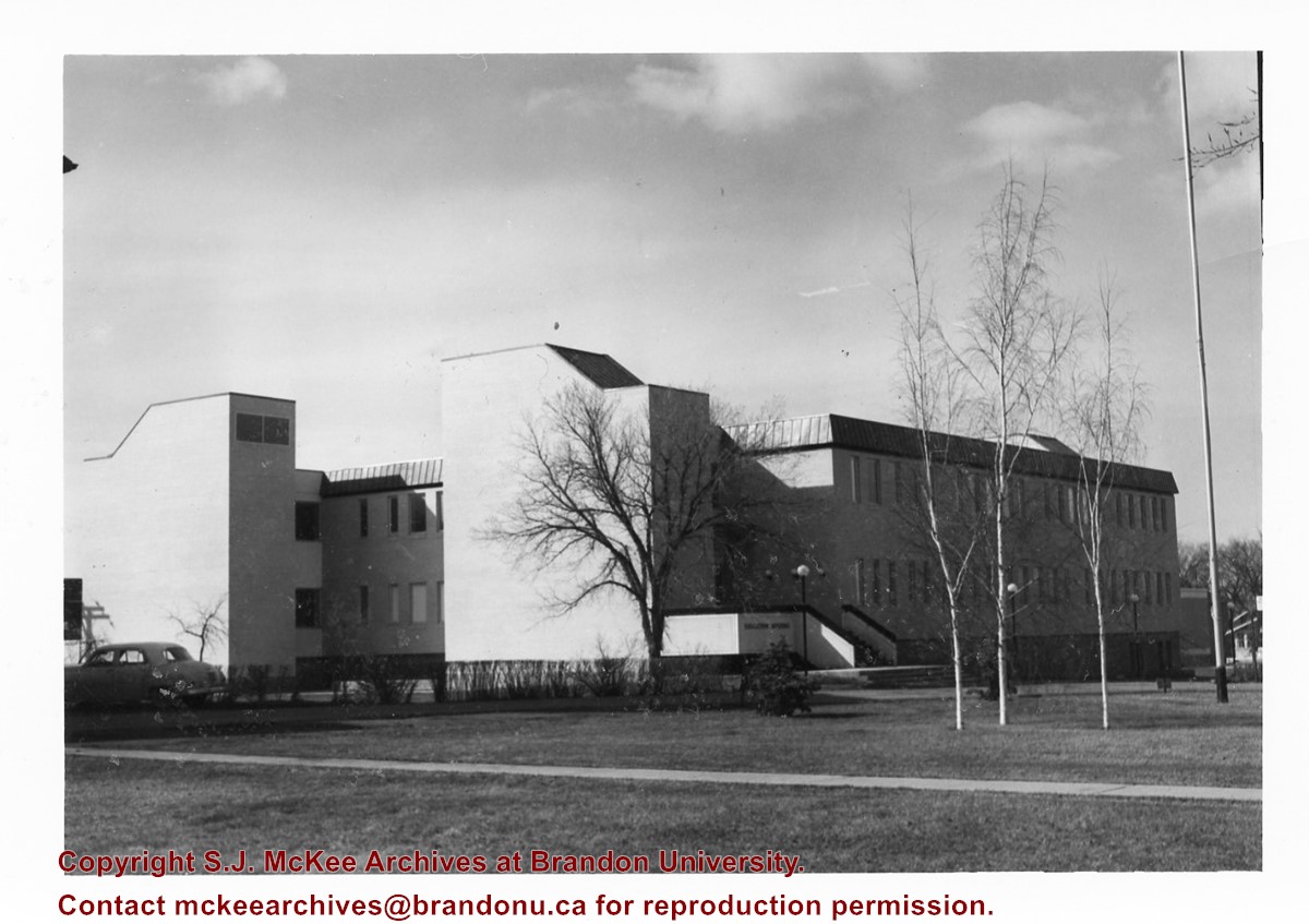
Image shows the Brandon College campus from 17th Street looking southwest. The photo was taken after the completion of the original Music Building in 1963, but construction of the Education Building. Also visible are a number of properties on the 200 block of 18th Street and the 200 block of 20th Street.
Subject Access
aerial photographs
campus photographs
campus buildings
Brandon streets
Images
Show Less

Aerial view: Brandon College from 23rd Street

http://archives.brandonu.ca/en/permalink/descriptions602
Part Of
Brandon University Photograph collection
Description Level
Item
GMD
graphic
Date Range
[1963-1966]
Part Of
Brandon University Photograph collection
Description Level
Item
Series Number
2.1
Item Number
BUPC 2.1.9
GMD
graphic
Date Range
[1963-1966]
Physical Description
5" x 4" (b/w)
Scope and Content
Image is looking east northeast from approximately the 300 block of 23rd Street between Lorne and Louise Avenues. Photograph shows the Brandon College campus after the opening of the original Music Building in 1963, but before the construction of the Education Building in 1966. A number of house on the 300 blocks of 22nd and 21st Streets are visible in the foreground, with the A.E. McKenzie Seed Co., the Prince Edward Hotel and various grain elevators on the horizon.
Subject Access
aerial photographs
campus photographs
campus buildings
Brandon streets
Grain elevators
Images
Show Less

Education Building

http://archives.brandonu.ca/en/permalink/descriptions679
Part Of
Education building
Description Level
Item
GMD
graphic
Date Range
c. 1967
Part Of
Education building
Description Level
Item
Series Number
2.7
Item Number
2.7.1
GMD
graphic
Date Range
c. 1967
Physical Description
3.5" x 5.5" (colour)
Scope and Content
Postcard of the Education Building. Shows the east side of the building and the main entrance.
Images
Show Less

Education Building

http://archives.brandonu.ca/en/permalink/descriptions682
Part Of
Education building
Description Level
Item
GMD
graphic
Date Range
c. 1967
Part Of
Education building
Description Level
Item
Series Number
2.7
Item Number
2.7.2
GMD
graphic
Date Range
c. 1967
Physical Description
4.75" x 3.5" (b/w)
Scope and Content
Photograph is looking northwest from the front lawn and shows parked cars and the Education Building, particularly the south side of the building.
Images
Show Less

Education Building

http://archives.brandonu.ca/en/permalink/descriptions865
Part Of
Education building
Description Level
Item
GMD
graphic
Date Range
c. early 1970s
Part Of
Education building
Description Level
Item
Series Number
2.7
Item Number
2.7.3
GMD
graphic
Date Range
c. early 1970s
Physical Description
5" x 2.25" (b/w)
Scope and Content
Photograph is looking west from the driveway and shows the east side of the Education Building, including the main entrance.
Images
Show Less

Education Building

http://archives.brandonu.ca/en/permalink/descriptions868
Part Of
Education building
Description Level
Item
GMD
graphic
Date Range
c. 1970s
Part Of
Education building
Description Level
Item
Series Number
2.7
Item Number
2.7.5
GMD
graphic
Date Range
c. 1970s
Physical Description
3.25" x 4.5" (b/w)
Scope and Content
Photograph is looking northwest from the front lawn and shows the south east corner of the Education Building.
Notes
Similar to BUPC 2.7.2 but without the cars and people in the foreground.
Images
Show Less

Education Building

http://archives.brandonu.ca/en/permalink/descriptions870
Part Of
Education building
Description Level
Item
GMD
graphic
Date Range
c. late 1960s/early 1970s
Part Of
Education building
Description Level
Item
Series Number
2.7
Item Number
2.7.6
GMD
graphic
Date Range
c. late 1960s/early 1970s
Physical Description
3.25" x 4" (b/w)
Scope and Content
Photograph is looking northwest from the front lawn and shows the south and east sides of the Education Building.
Notes
Similar to BUPC 2.7.5.
Images
Show Less

Education Building

http://archives.brandonu.ca/en/permalink/descriptions3023
Part Of
Education building
Description Level
Item
GMD
graphic
Date Range
May, 1978
Part Of
Education building
Description Level
Item
Series Number
2.7
Item Number
2.7.8
GMD
graphic
Date Range
May, 1978
Physical Description
3.5" x 5" (colour)
Scope and Content
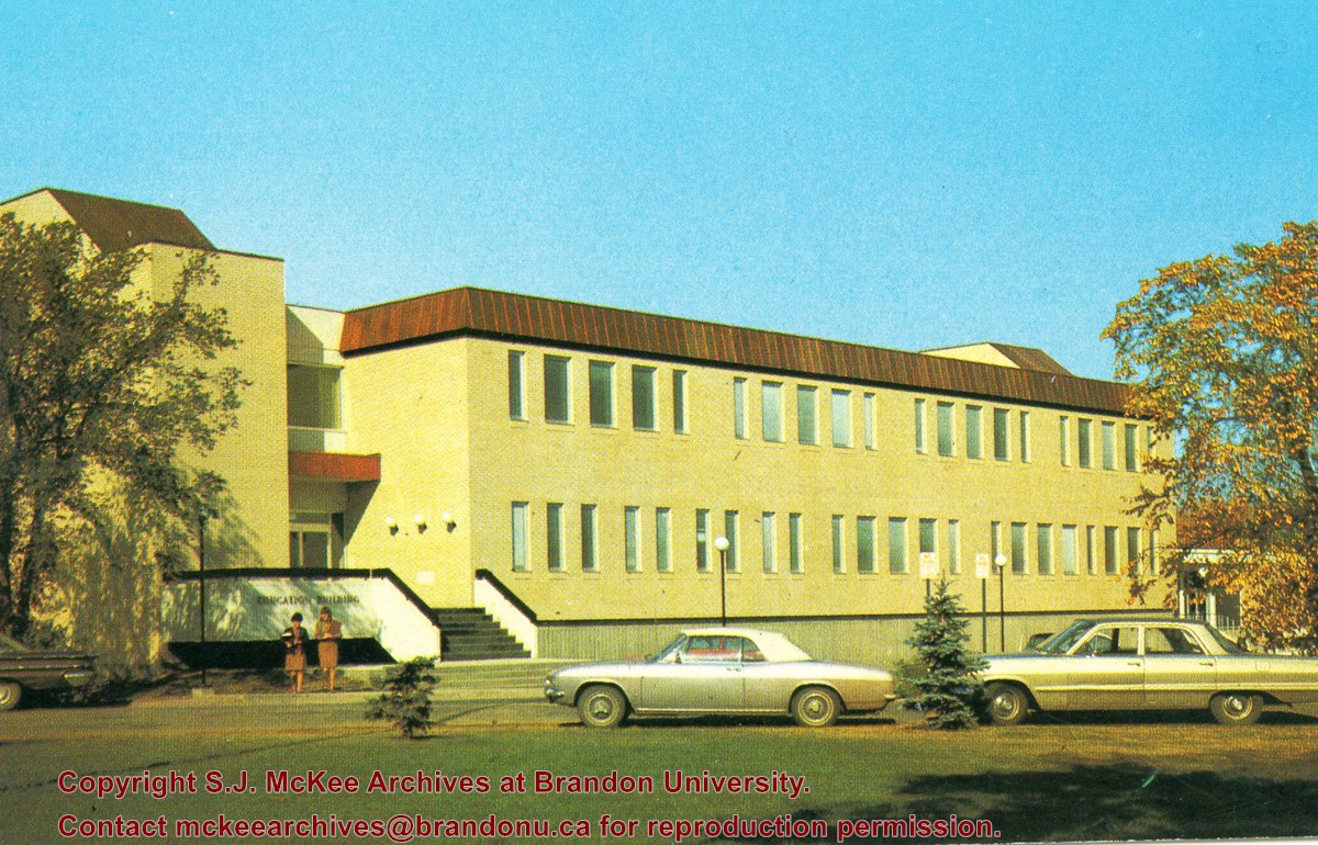
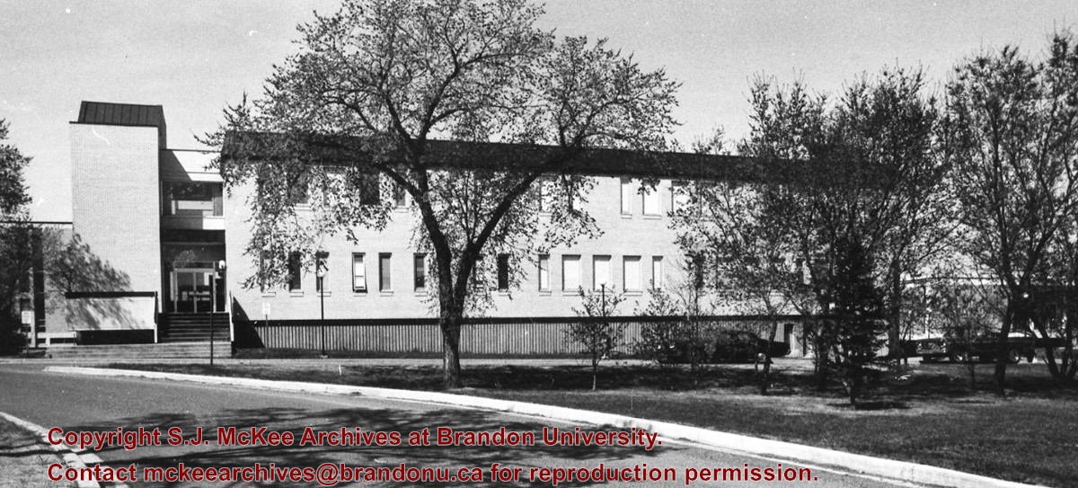
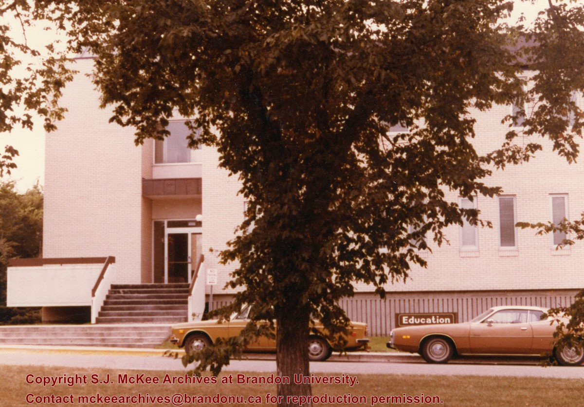
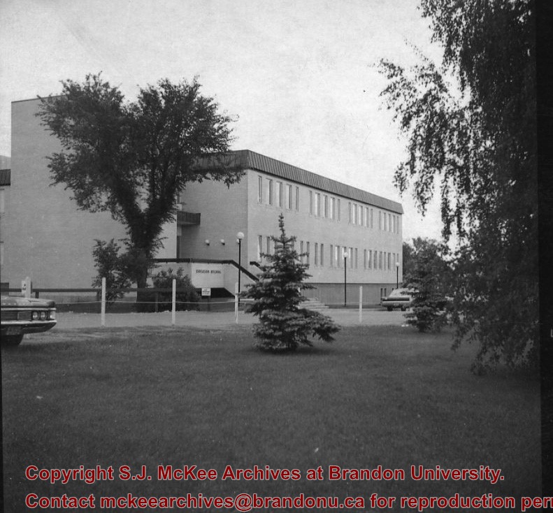
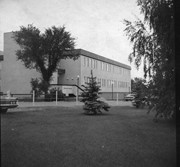
Photograph is looking west southwest and shows the Education Building, including the main entrance. Photograph was taken before the construction of the wheelchair ramp (built in the mid 1980s).
Images
Show Less

Education Building

http://archives.brandonu.ca/en/permalink/descriptions8210
Part Of
Education building
Description Level
Item
GMD
graphic
Date Range
c. 1971
Part Of
Education building
Description Level
Item
Series Number
2.7
Item Number
2.7.9
GMD
graphic
Date Range
c. 1971
Physical Description
2.5" x 2.5" (b/w)
Scope and Content
Contact print is looking northwest from the front lawn and shows the east side and southeast corner of the Education Building.
Images
Show Less

A.E. McKenzie Building

http://archives.brandonu.ca/en/permalink/descriptions860
Part Of
Brandon University Photograph collection
Description Level
Item
GMD
graphic
Date Range
c. mid 1980s
Part Of
Brandon University Photograph collection
Description Level
Item
Series Number
2.4
Item Number
BUPC 2.4.2
GMD
graphic
Date Range
c. mid 1980s
Physical Description
3.5" x 5" (colour)
Scope and Content
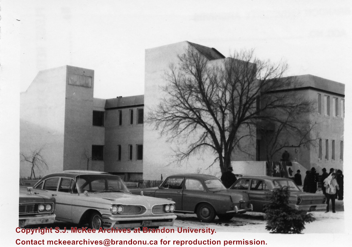
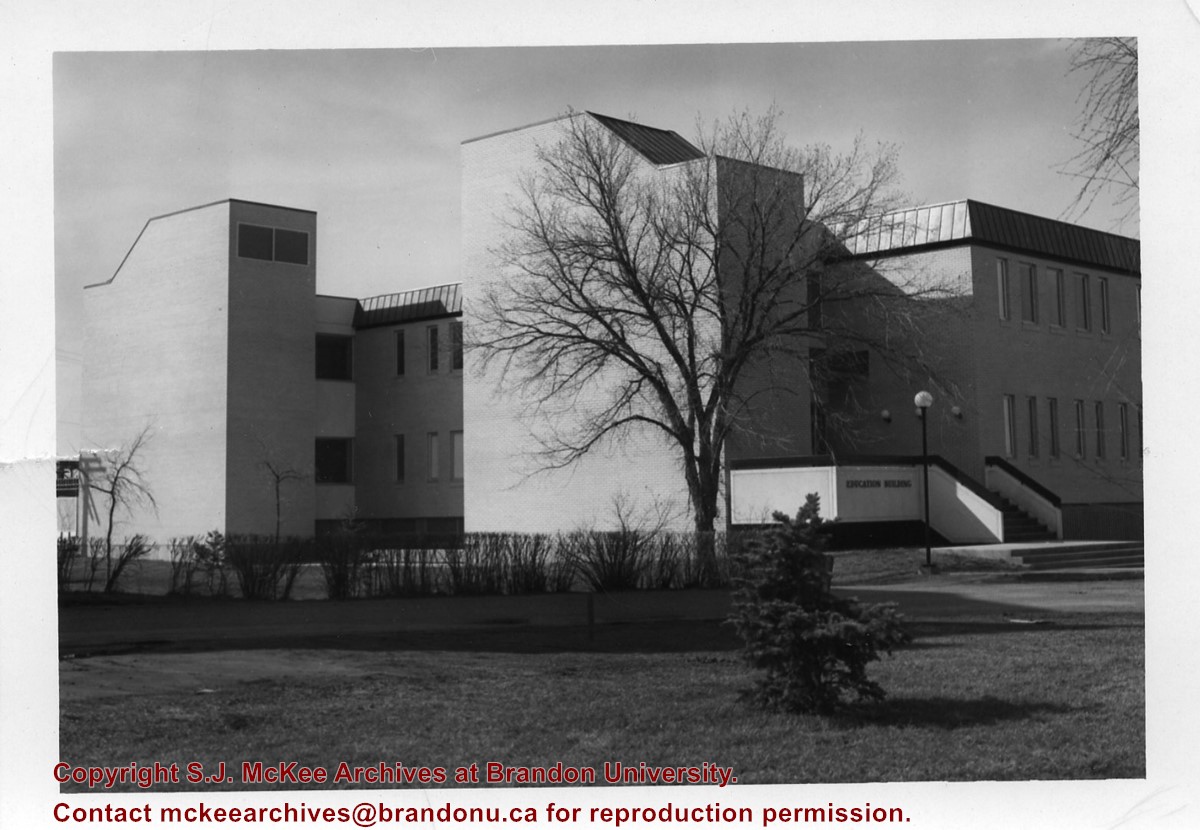
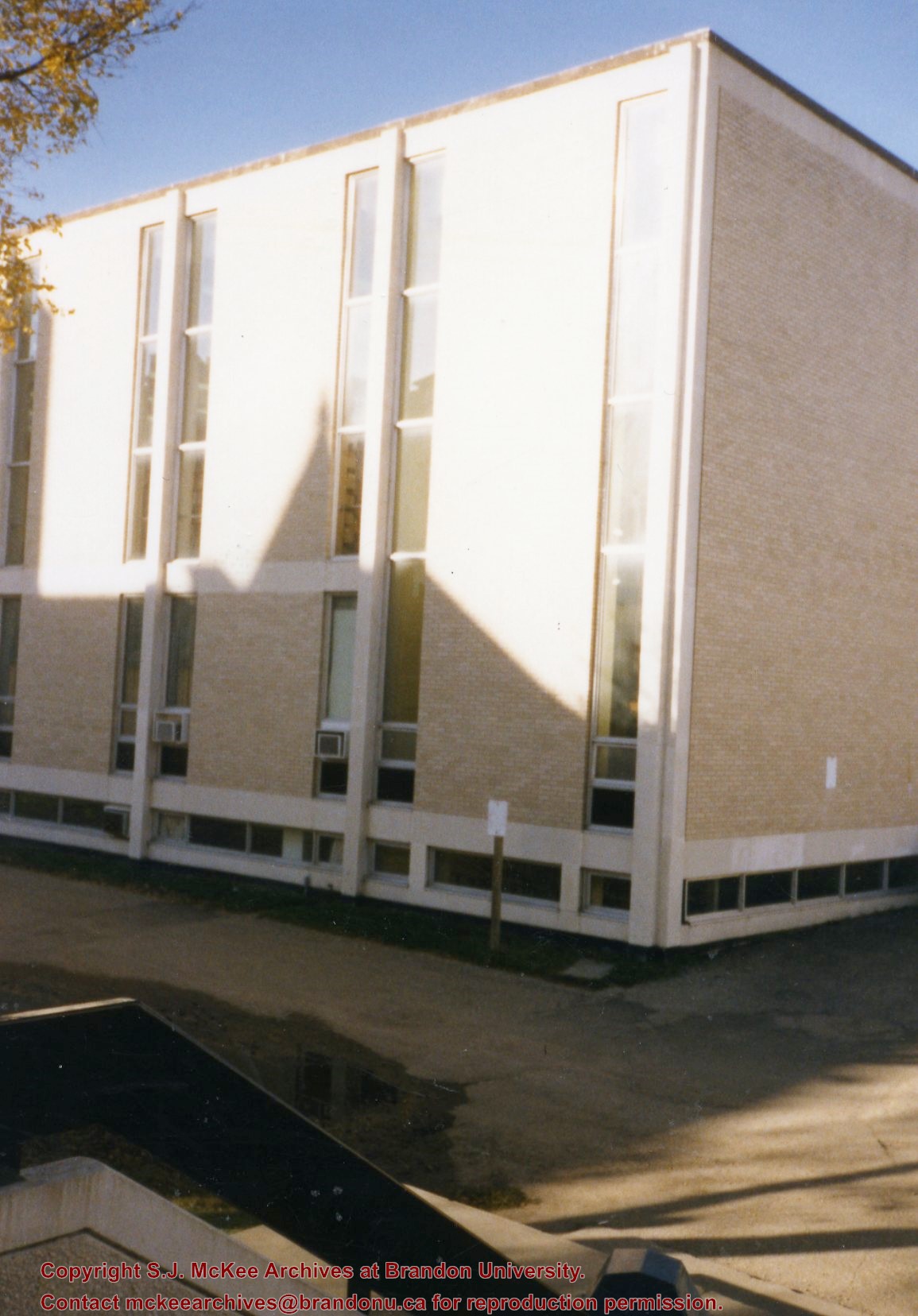
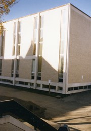
Photograph is looking southwest from the back steps of the Education Building and shows the northeast corner of the A.E. McKenzie Building, which housed the Library and Faculty of Arts.
Images
Show Less

John R. Brodie Science Centre flower beds

http://archives.brandonu.ca/en/permalink/descriptions3026
Part Of
Brandon University Photograph collection
Description Level
Item
GMD
graphic
Date Range
May 1978
Part Of
Brandon University Photograph collection
Description Level
Item
Series Number
2.1
Item Number
BUPC 2.1.42
GMD
graphic
Date Range
May 1978
Physical Description
5" x 3.5" (colour)
Scope and Content
Photograph shows a number of flower beds located on the north side of the John R. Brodie Science Centre.
Subject Access
campus photographs
Images
Show Less

A.E. McKenzie Building construction

http://archives.brandonu.ca/en/permalink/descriptions627
Part Of
Brandon University Photograph collection
Description Level
Item
GMD
graphic
Date Range
[1959-1960]
Part Of
Brandon University Photograph collection
Description Level
Item
Series Number
2.4
Item Number
BUPC 2.4.6
GMD
graphic
Date Range
[1959-1960]
Physical Description
5" x 7" (b/w)
Scope and Content
Photograph is looking northeast (?) and shows the construction of the A.E. McKenzie Building (Library and Arts Building) during the winter.
Subject Access
campus buildings
Images
Show Less

20 records – page 1 of 1.