The Medicine Hat Exhibition and Stampede Parade Day was held on Thursday, July 19, 1962, at 9:30 a.m. The local newspaper reported that approximately 24,000 people were in attendance to see parade marshall Rod Ashburner leading 175 entries consisting of 90 floats, 75 horses, and 10 bands. There were 19 parade categories eligible for $12,000 in prize money and included: junior and senior cowboys and cowgirls; fancy and Shetland ponies; sulky class open; comic, commercial, industrial and organizational floats; decorated cars; special ranch class; 4-H Clubs; and a non-competitive class.
The parade route started at Second St. and Allowance Ave., from Second St. to Ash Ave., north on Ash to First St. SE., from First St. S.E. to Fourth Ave., south to Second St. to South Railway St., south on South Railway St. to Third St., with a finish at McLeod Trail. A route map was published in the Medicine Hat News the day before the parade.
Aerial photographs of the parade were taken by Medicine Hat News photographer Howard Heid (1930-2005) from the private helicopter of John Bourn. Bourn was a pilot from Woodville, Wisconsin, who chartered his four-seater helicopter for sight-seers at exhibitions and stampedes across the county.
(Sources: Pat Currie, "Let 'Er Go!," Medicine Hat News, 19 July 1962,1; Harald Gunderson, "'Eye in the Sky' Best Parade View," Medicine Hat News, 19 July 1962,1; "Parade Starts at 9:30 Sharp," 18 July 1962)
Scope and Content
Photograph shows an aerial view of the Medicine Hat Exhibition and Stampede Parade route with a focus on the First Street SE and Ash Street. A residential area showing homes with extensive backyard gardens can be seen.
Notes
This photograph shows the neighbourhood before rezoning and commercial development.
The Medicine Hat Exhibition and Stampede Parade Day was held on Thursday, July 19, 1962, at 9:30 a.m. The local newspaper reported that approximately 24,000 people were in attendance to see parade marshall Rod Ashburner leading 175 entries consisting of 90 floats, 75 horses, and 10 bands. There were 19 parade categories eligible for $12,000 in prize money and included: junior and senior cowboys and cowgirls; fancy and Shetland ponies; sulky class open; comic, commercial, industrial and organizational floats; decorated cars; special ranch class; 4-H Clubs; and a non-competitive class.
The parade route started at Second St. and Allowance Ave., from Second St. to Ash Ave., north on Ash to First St. SE., from First St. S.E. to Fourth Ave., south to Second St. to South Railway St., south on South Railway St. to Third St., with a finish at McLeod Trail. A route map was published in the Medicine Hat News the day before the parade.
Aerial photographs of the parade were taken by Medicine Hat News photographer Howard Heid (1930-2005) from the private helicopter of John Bourn. Bourn was a pilot from Woodville, Wisconsin, who chartered his four-seater helicopter for sight-seers at exhibitions and stampedes across the county.
(Sources: Pat Currie, "Let 'Er Go!," Medicine Hat News, 19 July 1962,1; Harald Gunderson, "'Eye in the Sky' Best Parade View," Medicine Hat News, 19 July 1962,1; "Parade Starts at 9:30 Sharp," 18 July 1962)
Scope and Content
Photograph shows an aerial view of the Medicine Hat Exhibition and Stampede Parade route with a focus west of the railway allowance, showing First Street SE, Second Street SE, and Third Street SE.
Notes
This photograph shows the neighbourhood before rezoning and commercial development.
The Medicine Hat Exhibition and Stampede Parade Day was held on Thursday, July 19, 1962, at 9:30 a.m. The local newspaper reported that approximately 24,000 people were in attendance to see parade marshall Rod Ashburner leading 175 entries consisting of 90 floats, 75 horses, and 10 bands. There were 19 parade categories eligible for $12,000 in prize money and included: junior and senior cowboys and cowgirls; fancy and Shetland ponies; sulky class open; comic, commercial, industrial and organizational floats; decorated cars; special ranch class; 4-H Clubs; and a non-competitive class.
The parade route started at Second St. and Allowance Ave., from Second St. to Ash Ave., north on Ash to First St. SE., from First St. S.E. to Fourth Ave., south to Second St. to South Railway St., south on South Railway St. to Third St., with a finish at McLeod Trail. A route map was published in the Medicine Hat News the day before the parade.
Aerial photographs of the parade were taken by Medicine Hat News photographer Howard Heid (1930-2005) from the private helicopter of John Bourn. Bourn was a pilot from Woodville, Wisconsin, who chartered his four-seater helicopter for sight-seers at exhibitions and stampedes across the county.
(Sources: Pat Currie, "Let 'Er Go!," Medicine Hat News, 19 July 1962,1; Harald Gunderson, "'Eye in the Sky' Best Parade View," Medicine Hat News, 19 July 1962,1; "Parade Starts at 9:30 Sharp," 18 July 1962)
Scope and Content
Photograph shows an aerial view of possibly 8th Street NW and Tweed Avenue NW. A Safeway grocery store, park and residential area are visible. Many of hte homes appear to have gardens.
Notes
This photograph shows the neighbourhood before rezoning and commercial development.
The Medicine Hat Exhibition and Stampede Parade Day was held on Thursday, July 19, 1962, at 9:30 a.m. The local newspaper reported that approximately 24,000 people were in attendance to see parade marshall Rod Ashburner leading 175 entries consisting of 90 floats, 75 horses, and 10 bands. There were 19 parade categories eligible for $12,000 in prize money and included: junior and senior cowboys and cowgirls; fancy and Shetland ponies; sulky class open; comic, commercial, industrial and organizational floats; decorated cars; special ranch class; 4-H Clubs; and a non-competitive class.
The parade route started at Second St. and Allowance Ave., from Second St. to Ash Ave., north on Ash to First St. SE., from First St. S.E. to Fourth Ave., south to Second St. to South Railway St., south on South Railway St. to Third St., with a finish at McLeod Trail. A route map was published in the Medicine Hat News the day before the parade.
Aerial photographs of the parade were taken by Medicine Hat News photographer Howard Heid (1930-2005) from the private helicopter of John Bourn. Bourn was a pilot from Woodville, Wisconsin, who chartered his four-seater helicopter for sight-seers at exhibitions and stampedes across the county.
(Sources: Pat Currie, "Let 'Er Go!," Medicine Hat News, 19 July 1962,1; Harald Gunderson, "'Eye in the Sky' Best Parade View," Medicine Hat News, 19 July 1962,1; "Parade Starts at 9:30 Sharp," 18 July 1962)
Scope and Content
Photograph shows an aerial view of the Medicine Hat Exhibition and Stampede Parade route with a focus on the First Street SE and and the South Railway Street merge. A number of gas stations and garages are visible along this route and include Texaco, Shell, Ford, and B/A. The Fraternal Order of Eagles lodge is also visible.
Notes
This photograph shows the neighbourhood before rezoning and commercial development.
Photographs have been glued to a backing board that has warped over time
Scope and Content
Photograph shows parade floats travelling on 100 block of 8th Street (Brandon). Horse-drawn floats appear to belong to the Amalgamated Society of Carpenters and Joiners, Murdock/Murdoch Brothers (furniture dealers), and F.W. Durst (cement contractor). Businesses visible in the background include the Sylvester Brothers Manufacturing Company and McDiarmid and Clarke lumber and fuel yard. Spectators in the foreground are leaning on a wooden fence likely belonging to the Old City Hall.
Notes
Writing on the front of the photograph matting reads: 315 July 1906. Two photographs (20-2009.7, 20-2009.6) are glued on the reverse side. Page appears to be from a photo album.
Photographs have been glued to a backing board that has warped over time
Scope and Content
Photograph shows street view of north side of Rosser Avenue, primarily the 700 block. Horse and buggies are travelling on the avenue and pedestrians fill the sidewalks. Union Jacks and English flags are mounted from the windows on the Fleming and Beaubier blocks. Flag banners are drapped across Rosser Avenue. Businesses visible in the Fleming Block include: Lowes Brothers Clothing and Spring Park Nurseries. Businesses visible in the Beaubier Block include the Empire Hotel. Businesses east of the Empire Hotel are grocer A.M. Percival and the Brandon Hardware Company. An advertisement for the Northern Bank is affixed to a telephone pole on the southside of the street.
Notes
Writing on the front of the photograph matting reads: July 1 1906, 314. One photograph (20-2009.8) is glued below and another, 20-2009.6, is glued on the reverse side. Page appears to be from a photo album.
Photographs have been glued to a backing board that has warped over time
Scope and Content
Photograph shows street view of north side of Rosser Avenue, primarily the 700 block. Horse and buggies are travelling on the avenue and pedestrians fill the sidewalks. Union Jacks and English flags are mounted from the windows on the Fleming and Beaubier blocks. Flag banners are drapped across Rosser Avenue. Businesses visible in the Fleming Block include: Lowes Brothers Clothing and Spring Park Nurseries. Businesses visible in the Beaubier Block include the Empire Hotel. Businesses east of the Empire Hotel are grocer A.M. Percival and the Brandon Hardware Company. An advertisement for the Northern Bank is affixed to a telephone pole on the southside of the street. The street is lined with litter and a number of dogs can be seen roaming the area.
Notes
Writing on the front of the photograph matting reads: 313 July 1906. One photograph (20-2009.8) is glued below and another, 20-2009.6, is glued on the reverse side. Page appears to be from a photo album.
Photographs have been glued to a backing board that has warped over time
History / Biographical
John Dickson (b. 17 Mar 1854, Scotland; d.15 April 1926, Brandon) was considered one of Brandon’s pioneer dentists. Dickson immigrated to Canada in 1857, where he lived in Hamilton, Ontario, for a number of years. Dickson then came to Manitoba and operated a grocery in Chater before he studied dentistry, graduating from the University of Minnesota in 1886. Dickson settled in Brandon where he married Anna Louise Harrison on 28 December 1891. (Source: “Pioneer Dentist of Brandon in Dr. John Dickson,” Brandon Daily Sun 16 Apr 1926)
The couple had four children: Mrs. Irving Cross [Mary Louise, b.20 Dec 1892, Brandon; d. 22 Oct 1981, Saratoga, NY]; Dr. John Harrison Dickson [b. 26 Aug 1894, Brandon; d. 17 June 1956, Killarney]; Dr. Stanley Rodgers Dickson [b. 18 Feb 1896, Brandon; d. 25 July 1963, Brandon]; and Mrs. Emile Baldeschweiler [Isobel Marion Coates, b. 13 Nov 1900, Brandon; d.?] of New York. (Source: Manitoba Vital Statistics database)
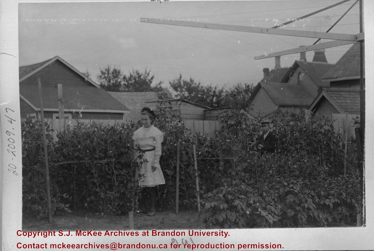
Scope and Content
Photograph is of a girl and a boy standing amongst sweet peas in a backyard garden. A clothes line is visible in the foreground. The children, Mary and Stanley, are possibly those of Brandon dentist John Dickson.
Notes
Writing on the front of the photograph matting reads: 291. Page appears to be from a photo album.
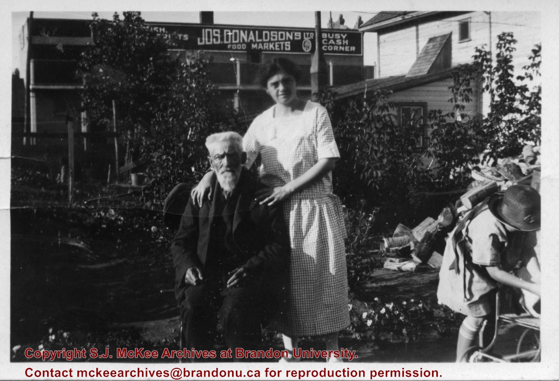
Joseph Donaldson's Ltd. Food Market appears in the Henderson's Brandon City Directory from 1906 to 1929. Donaldson's main meat/butcher shop was located at 813 Rosser Avenue. A second branch was opened by 1914 at 228 Rosser Avenue but relocated to 654 Tenth Street by 1917. The branch relocated by 1921 to 662 Tenth Street where it remained until ca.1929. This address was referred to as the "Busy Corner" in the Henderson's Directory. In 1931, butcher Ted Hill appears to have taken over the Donaldson's establishments.
Scope and Content
Photograph shows George Pope sitting in a backyard. Standing next to him is Isabella Louise McGuinness (Pope). A young girl, perhaps Ruth McGuinness, is standing over a stroller. A wood pile and garden plants can be seen in the backyard. An advertisement for Joseph Donaldson's Ltd Food Markets can be seen on a business beside the residence.
Notes
Writing on the back of the photograph reads: This is mum her uncle George Pope who came to Brandon in 1880 (I think) in the back yard of 708-10th Street. It looked like Ruth in the lower right corner. I was interested in the Donaldson advertising.
Photographs have been glued to a backing board that has warped over time
History / Biographical
John Dickson (b. 17 Mar 1854, Scotland; d.15 April 1926, Brandon) was considered one of Brandon’s pioneer dentists. Dickson immigrated to Canada in 1857, where he lived in Hamilton, Ontario, for a number of years. Dickson then came to Manitoba and operated a grocery in Chater before he studied dentistry, graduating from the University of Minnesota in 1886. Dickson settled in Brandon where he married Anna Louise Harrison on 28 December 1891.
The couple had four children: Mrs. Irving Cross [Mary Louise, b.20 Dec 1892, Brandon; d. 22 Oct 1981, Saratoga, NY]; Dr. John Harrison Dickson [b. 26 Aug 1894, Brandon; d. 17 June 1956, Killarney]; Dr. Stanley Rodgers Dickson [b. 18 Feb 1896, Brandon; d. 25 July 1963, Brandon]; and Mrs. Emile Baldeschweiler [Isobel Marion Coates, b. 13 Nov 1900, Brandon; d.?] of New York.
Sources: “Pioneer Dentist of Brandon in Dr. John Dickson,” Brandon Daily Sun 16 Apr 1926 and Manitoba Vital Statistics database.
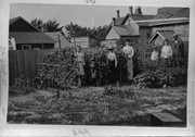
Scope and Content
Photograph is a family in a garden plot in a residential area. Four children, two women, and a man are standing amongst sweet peas. Out buildings of other properties can be seen. Possibly standing from left to right are members of the Dickson family: Mary, Isobel, John Harrison, Annie Louise (wife), Stanley Rodgers, Mrs. Harrison (mother-in-law), and John (husband).
Notes
Writing on the front of the photograph matting reads: 289. Page appears to be from a photo album.
The International Peace Garden is situated on the international border between Manitoba and North Dakota, adjacent to the Canadian Border Services Boissevain port of entry and the U.S. Customs and Border Protection Agency's Dunseith port of entry. The dedication for the International Peace Garden was held on July 14, 1932. It was estimated that 50,000 people were in attendance on opening day. The park is 9.5-square kilometers or 3.54-square miles.
Custodial History
Pictures were sent to Fred McGuinness in 1970 from E.M. Bergson of Brandon.
Scope and Content
Photograph shows large crowds surrounding a stone cairn draped in American and Union Jack flags. According to the International Peace Garden website, the pictured cairn was built from stones gathered from Manitoba and North Dakota. The crowds gathered for the 1932 dedication of the International Peace Garden.
Notes
The back of the photograph is stamped: Enameloid Velox Print by the Jul 27 1932, Chicago Postal Photo Supplies, Regina, Sask.
The International Peace Garden is situated on the international border between Manitoba and North Dakota, adjacent to the Canadian Border Services Boissevain port of entry and the U.S. Customs and Border Protection Agency's Dunseith port of entry. The dedication for the International Peace Garden was held on July 14, 1932. It was estimated that 50,000 people were in attendance on opening day. The park is 9.5-square kilometers or 3.54-square miles.
Custodial History
Pictures were sent to Fred McGuinness in 1970 from E.M. Bergson of Brandon.
Scope and Content
Photograph shows the crowded parking lot at the International Peace Garden's 1932 dedication ceremony. People mill amongst the automobiles and tents can be seen in the background.
Notes
The back of the photograph is stamped: Enameloid Velox Print by the Jul 27 1932, Chicago Postal Photo Supplies, Regina, Sask.
Photograph shows the 800 block of Rosser Avenue facing west. On the south side of Rosser Avenue the Nation Block, Christie's Bookstore, and Reesor's Clock can be seen. A number of horse and buggies/carriages are travelling along Rosser Avenue.
Corners of photograph mat are bent. Picture is cracked.
Scope and Content
Photograph shows an early view of Brandon's 6th Street in the 1880s. The Winter & O'Neail Groceries & Provisions and James Smart Hardware storefronts have been photographed. A street sign designating 6th Street can be seen below the Winter & O'Neail sign. A horse and cart is parked in front of the grocery store. A number of men wearing hats and jackets are standing along the boardwalk while posing for the picture. Lumber/timber saws are displayed in teh windows of the hardware store.
Notes
Front of photograph reads: 6th Street, Brandon, Manitoba, 1881-1882, Entrance [to Winter & O'Neail] corner of Rosser Ave & 6th Street.
Photograph mat is bent. Emulsion problems with image.
Scope and Content
Photograph shows Rosser Avenue in its incipient stages. Canvas tents are mixed amongst wooden structures. The James Smart Hardware store, Winter & O'Neail Groceries & Provisions, and the law office of F.G.A. Henderson in the Molesworth Block can be seen on the north side of Rosser Avenue. A street sign designating 6th Street can be seen below the Winter & O'Neail sign. A horse and buggie is traveling down the dirt track that is Rosser Avenue. Groups of men can be seen congregating outside some of the local businesses.
Notes
Front of photograph reads: Rosser Avenue, Brandon 1882-1883, from east of Six Street. Back of photograph is stamped: I. Bennetto & Co., Photographers, Opposite Post-Office, Winnipeg, Man.
Left hand corner of mat is bent. Mock-up instructions are written in pencil at the bottom right hand corner. Portions of the photograph itself are marked with pen.
History / Biographical
The Queen's Hotel was located on the corner of Rosser Avenue and Tenth Street (Steen & Boyce, 1882. Brandon, Manitoba, Canada and Her Industries. Steen & Boyce Publishers Printers & Binders, 81.). Therefore this photo appears to display Rosser Avenue looking east. P.E. 11/06/09
Scope and Content
Photograph shows early Rosser Avenue under construction between 9th Street and 10th Street in the 1880s. Buildings that line the avenue are wood framed and there are wooden boardwalks in front of a few structures. On the north side of Rosser Avenue signs for Fortier & Bucke Commision Agents and Transit House (Hotel) can be seen. On the south side of Rosser Avenue, the Queen's Hotel and Robinson Brothers and Company groceries and dry goods store are open for business. A family appears to be standing on the stoop at the dry goods store. A boy is lounging in the entryway of the Queen's Hotel. A man is standing on a wooden plank that extends across the dirt road of Rosser Avenue between the dry goods store and the commission agents' shop.
Photograph shows the 700-block of Rosser Avenue facing west. Visible businesses on the north side of Rosser Avenue include: Burchill's Music Store, E.W. Woolworth Co. Ltd. 5-10 and 15 Cent Store in the E.E. Evans Block, Empire Hotel, and W.A. Paterson Drugs. Automobiles are parked on both sides of the avenue and at the time the photograph was taken, Rosser Avenue was a two-way street.
Notes
Part of "Souvenir of Brandon, Manitoba, Canada [viewbook], Printed by Photogelatine Engraving Co. Limited, Ottawa." Dates obtained from the Burchill's Music Store Henderson's Brandon City Directory listings (1927-1929). Writing on the front of the photograph reads: Rosser St. [sic.] - Brandon, Man.
Photograph shows a street view of 10th Street facing north. There are many automobiles parked along the street and several pedestrians in summer dress are on the sidewalks and street. Visible business signs include: Hentzman & Co. Pianos (possibly belonging to J.J.H. McLean Co. Ltd.), the Strand Theatre, T & D Clothes, Campbell & Campbell, the CPR Station, and Bowling Alley and Billiards.
Notes
Part of "Souvenir of Brandon, Manitoba, Canada [viewbook], Printed by Photogelatine Engraving Co. Limited, Ottawa." Dates obtained from the Burchill's Music Store Henderson's Brandon City Directory listings (1927-1929). Writing on the front of the photograph reads: 10th St., looking north (C.P.R. Station at end of Street) Brandon, Man.


