Skip header and navigation

Revise Search

20 records – page 1 of 1.

Aerial View of Core Area

http://archives.brandonu.ca/en/permalink/descriptions9267
Part Of
RG 11 Lawrence Stuckey fonds
Description Level
Item
GMD
graphic
Date Range
1977
Accession Number
1-2002
Part Of
RG 11 Lawrence Stuckey fonds
Creator
D.L. Bottley
Description Level
Item
Series Number
3.1
Item Number
1-2002.3.1CA19(1)
Accession Number
1-2002
GMD
graphic
Date Range
1977
Physical Description
3 1/2" x 5"
Material Details
Negative
Custodial History
For custodial history see the collection level description of the Lawrence Stuckey collection.
Scope and Content
Aerial view of Brandon's core area
Notes
[Mr. Stuckey put 2 negatives in the same envelope. We have separated them and numbered them CA19(1) and CA19(2).]
Name Access
Aerial View of Core Area
Subject Access
downtowns
aerial photography
Brandon Street Scenes After 1940
Repro Restriction
The McKee Archives is the copyright holder for the Stuckey materials.
Storage Location
Lawrence Stuckey collection
Images
Show Less

Aerial View of Core Area

http://archives.brandonu.ca/en/permalink/descriptions9268
Part Of
RG 11 Lawrence Stuckey fonds
Description Level
Item
GMD
graphic
Date Range
1977
Accession Number
1-2002
Part Of
RG 11 Lawrence Stuckey fonds
Creator
D.L. Bottley
Description Level
Item
Series Number
3.1
Item Number
1-2002.3.1CA19(2)
Accession Number
1-2002
GMD
graphic
Date Range
1977
Physical Description
3 1/2" x 5"
Material Details
Negative
Custodial History
For custodial history see the collection level description of the Lawrence Stuckey collection.
Scope and Content
Aerial view of Brandon's core area
Notes
[Mr. Stuckey put 2 negatives in the same envelope. We have separated them and numbered them CA19(1) and CA19(2).]
Name Access
Aerial View of Core Area
Subject Access
downtowns
aerial photography
Brandon Street Scenes After 1940
Repro Restriction
The McKee Archives is the copyright holder for the Stuckey materials.
Storage Location
Lawrence Stuckey collection
Images
Show Less

Aerial view: Brandon College

http://archives.brandonu.ca/en/permalink/descriptions594
Part Of
Brandon University Photograph collection
Description Level
Item
GMD
graphic
Date Range
[fall 1964?]
Part Of
Brandon University Photograph collection
Description Level
Item
Series Number
2.1
Item Number
BUPC 2.1.2
GMD
graphic
Date Range
[fall 1964?]
Physical Description
5" x 4" (b/w)
Scope and Content
Brandon College looking south from 19th Street. Photograph was taken after Flora Cowan Hall was built but before construction of the Education Building.
Subject Access
aerial photographs
campus photographs
campus buildings
Brandon streets
Images
Show Less

Aerial view - Brandon University campus

http://archives.brandonu.ca/en/permalink/descriptions7989
Part Of
Brandon University Photograph collection
Description Level
Item
GMD
graphic
Date Range
c. 2000
Part Of
Brandon University Photograph collection
Creator
Photograph commissioned by Brandon University and taken by Yourview Aerial Scenics Ltd.
Description Level
Item
Series Number
2.1
Item Number
BUPC 2.1.55
GMD
graphic
Date Range
c. 2000
Physical Description
6" x 4" (colour)
Scope and Content
View is southwest from approximatley 16th Street between Princess and Rosser Avenues. Photograph shows the Brandon University campus, as well as surrounding residential blocks, including Flemming, J.R. Reid and Vincent Massey schools.
Subject Access
aerial photographs
campus photographs
campus buildings
Brandon streets
Images
Show Less

Aerial view - Brandon University campus

http://archives.brandonu.ca/en/permalink/descriptions7990
Part Of
Brandon University Photograph collection
Description Level
Item
GMD
graphic
Date Range
c. 2000
Part Of
Brandon University Photograph collection
Creator
Photograph commissioned by Brandon University and taken by Yourview Aerial Scenics Ltd.
Description Level
Item
Series Number
2.1
Item Number
BUPC 2.1.56
GMD
graphic
Date Range
c. 2000
Physical Description
6" x 4" (colour)
Scope and Content
View is west southwest from approximatley 16th Street between Princess and Lorne Avenues. Photograph shows the Brandon University campus, as well as surrounding residential blocks between 16th and 23rd Streets, Princess and Louise Avenues..
Subject Access
aerial photographs
campus photographs
campus buildings
Brandon streets
Images
Show Less

Aerial view - Brandon University campus

http://archives.brandonu.ca/en/permalink/descriptions7991
Part Of
Brandon University Photograph collection
Description Level
Item
GMD
graphic
Date Range
c. 2000
Part Of
Brandon University Photograph collection
Creator
Photograph commissioned by Brandon University and taken by Yourview Aerial Scenics Ltd.
Description Level
Item
Series Number
2.1
Item Number
BUPC 2.1.57
GMD
graphic
Date Range
c. 2000
Physical Description
6" x 4" (colour)
Scope and Content
View is west from approximatley 17th Street between Lorne and Louise Avenues. Photograph shows a portion of the Brandon University campus (excluding the Education Building and anything north of it), as well as surrounding residential blocks from approximatley 17th Street to 22nd Street.
Subject Access
aerial photographs
campus photographs
campus buildings
Brandon streets
Images
Show Less

Aerial view - Brandon University campus

http://archives.brandonu.ca/en/permalink/descriptions7992
Part Of
Brandon University Photograph collection
Description Level
Item
GMD
graphic
Date Range
c. 1990
Part Of
Brandon University Photograph collection
Description Level
Item
Series Number
2.1
Item Number
BUPC 2.1.58
GMD
graphic
Date Range
c. 1990
Physical Description
5" x 3.5" (colour)
Scope and Content
View is west northwest from approximatley 16th Street and Louise Avenue. Photograph shows the Brandon University campus, prior to the Library Extension, and a large portion of the city to the west of the campus.
Subject Access
aerial photographs
campus photographs
campus buildings
Brandon streets
Images
Show Less

Aerial view - Brandon University campus

http://archives.brandonu.ca/en/permalink/descriptions7993
Part Of
Brandon University Photograph collection
Description Level
Item
GMD
graphic
Date Range
c. 1990
Part Of
Brandon University Photograph collection
Description Level
Item
Series Number
2.1
Item Number
BUPC 2.1.59
GMD
graphic
Date Range
c. 1990
Physical Description
5" x 3.5" (colour)
Scope and Content
View is northwest from approximatley 16th Street and Louise Avenue. Photograph shows the Brandon University campus, prior to the Library Extension, and a large portion of the city to the west of the campus.
Subject Access
aerial photographs
campus photographs
campus buildings
Brandon streets
Show Less

Aerial view - Brandon College looking southwest

http://archives.brandonu.ca/en/permalink/descriptions601
Part Of
Brandon University Photograph collection
Description Level
Item
GMD
graphic
Date Range
[1963-1966]
Part Of
Brandon University Photograph collection
Description Level
Item
Series Number
2.1
Item Number
BUPC 2.1.8
GMD
graphic
Date Range
[1963-1966]
Physical Description
5" x 4" (b/w)
Scope and Content
Image shows the Brandon College campus from 17th Street looking southwest. The photo was taken after the completion of the original Music Building in 1963, but construction of the Education Building. Also visible are a number of properties on the 200 block of 18th Street and the 200 block of 20th Street.
Subject Access
aerial photographs
campus photographs
campus buildings
Brandon streets
Images
Show Less

Aerial view: Brandon College from 23rd Street

http://archives.brandonu.ca/en/permalink/descriptions602
Part Of
Brandon University Photograph collection
Description Level
Item
GMD
graphic
Date Range
[1963-1966]
Part Of
Brandon University Photograph collection
Description Level
Item
Series Number
2.1
Item Number
BUPC 2.1.9
GMD
graphic
Date Range
[1963-1966]
Physical Description
5" x 4" (b/w)
Scope and Content
Image is looking east northeast from approximately the 300 block of 23rd Street between Lorne and Louise Avenues. Photograph shows the Brandon College campus after the opening of the original Music Building in 1963, but before the construction of the Education Building in 1966. A number of house on the 300 blocks of 22nd and 21st Streets are visible in the foreground, with the A.E. McKenzie Seed Co., the Prince Edward Hotel and various grain elevators on the horizon.
Subject Access
aerial photographs
campus photographs
campus buildings
Brandon streets
Grain elevators
Images
Show Less

Aerial View of Downtown

http://archives.brandonu.ca/en/permalink/descriptions9283
Part Of
RG 11 Lawrence Stuckey fonds
Description Level
Item
GMD
graphic
Date Range
[196-]
Accession Number
1-2002
Part Of
RG 11 Lawrence Stuckey fonds
Description Level
Item
Series Number
3.1
Item Number
1-2002.3.1CA28
Accession Number
1-2002
GMD
graphic
Date Range
[196-]
Physical Description
3 1/2" x 5"
Material Details
Negative
Custodial History
For custodial history see the collection level description of the Lawrence Stuckey collection.
Scope and Content
Aerial view of downtown Brandon, including area of new Gallery Mall.
Notes
[This eastward aerial view of downtown Brandon seems to portray an outdoor second-story parking garage proposed by the architectural firm Ward, MacDonald and Partners. The proposed overhead parking is depicted as running continuously from Sixth Street to Tenth Street along Rosser Avenue. The negative appears to have been made by photographing an existing illustration. P.E. 03/06/09]
Name Access
Aerial View of Downtown
Subject Access
downtowns
businesses
merchants
Brandon Street Scenes After 1940
Repro Restriction
The McKee Archives is the copyright holder for the Stuckey materials.
Storage Location
Lawrence Stuckey collection
Images
Show Less
Part Of
RG 11 Lawrence Stuckey fonds
Description Level
Item
GMD
graphic
Date Range
[n.d.]
Accession Number
1-2002
Part Of
RG 11 Lawrence Stuckey fonds
Creator
Clarke J. Smith, Brandon
Description Level
Item
Series Number
3.9
Item Number
1-2002.3.9.14
Accession Number
1-2002
GMD
graphic
Date Range
[n.d.]
Physical Description
9.75" x 6.75" (b/w)
Custodial History
Photograph was found by Al Mitchell, a City of Brandon employee.
Scope and Content
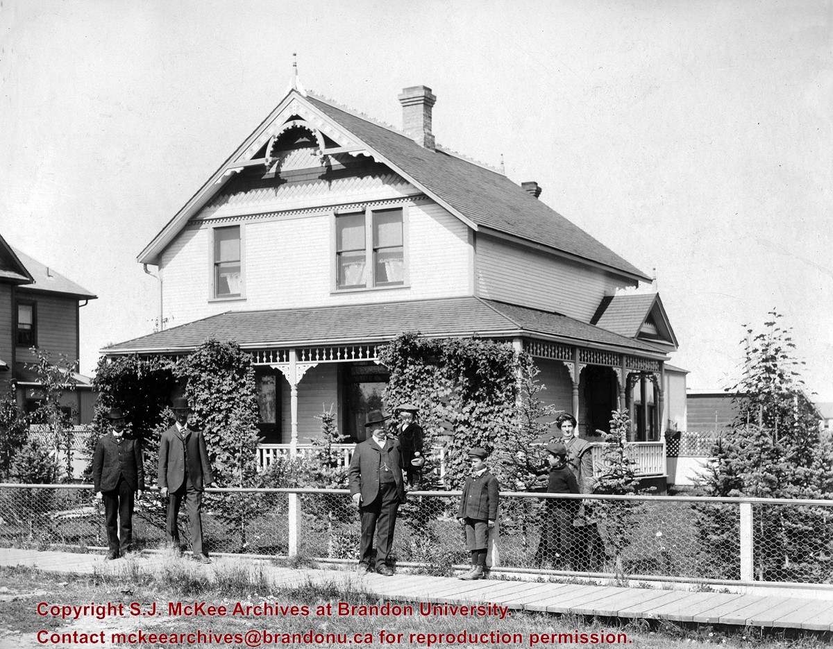
Photograph shows a family residence in the city. Four adults (three men and one woman) and three male children are standing at the property's fence or on the wooden sidewalk.
Repro Restriction
The McKee Archives is the copyright holder for the Stuckey materials.
Storage Location
RG 5 photograph storage drawer
Images
Show Less

Harry Bottley Store & Residence

http://archives.brandonu.ca/en/permalink/descriptions9585
Part Of
RG 11 Lawrence Stuckey fonds
Description Level
Item
GMD
graphic
Date Range
[195-?]
Accession Number
1-2002
Part Of
RG 11 Lawrence Stuckey fonds
Creator
D.L. Bottley?
Description Level
Item
Series Number
3.1
Item Number
1-2002.3.1EA35
Accession Number
1-2002
GMD
graphic
Date Range
[195-?]
Physical Description
2 1/2" x 3 1/2"
Material Details
Negative
Custodial History
For custodial history see the collection level description of the Lawrence Stuckey collection.
Scope and Content
Harry Bottley Store & Residence
Notes
Located at 819 Rosser Avenue East
[Mr. Stuckey did not file or number this negative. We have integrated it into the collection.]
Name Access
Harry Bottley Store & Residence
Subject Access
businesses
corner stores
convenience stores
Brandon business buildings & facilities after 1940
Repro Restriction
The McKee Archives is the copyright holder for the Stuckey materials.
Storage Location
Lawrence Stuckey collection
Images
Show Less

Rosser Avenue Looking East

http://archives.brandonu.ca/en/permalink/descriptions9191
Part Of
RG 11 Lawrence Stuckey fonds
Description Level
Item
GMD
graphic
Date Range
[ca. 1905]
Accession Number
1-2002
Part Of
RG 11 Lawrence Stuckey fonds
Description Level
Item
Series Number
3.1
Item Number
1-2002.3.1C4
Accession Number
1-2002
GMD
graphic
Date Range
[ca. 1905]
Physical Description
3 1/2" x 5"
Material Details
Negative
History / Biographical
The Strome & White Co. General Store (L. foreground; built 1902) became Brandon Hardware & Brandon Hardware block, later Ashdowns; The final tenant was Stylerite Hardware with two floors of residential suites. It was destroyed by fire March 27, 1983
Custodial History
For custodial history see the collection level description of the Lawrence Stuckey collection.
Scope and Content
View of Rosser Avenue, looking east from Seventh Street
Name Access
Rosser Avenue Looking East
Subject Access
downtowns
businesses
Brandon Street Scenes Before 1940
Repro Restriction
The McKee Archives is the copyright holder for the Stuckey materials.
Storage Location
Lawrence Stuckey collection
Images
Show Less

Rosser Avenue Looking West

http://archives.brandonu.ca/en/permalink/descriptions9192
Part Of
RG 11 Lawrence Stuckey fonds
Description Level
Item
GMD
graphic
Date Range
[ca. 1905]
Accession Number
1-2002
Part Of
RG 11 Lawrence Stuckey fonds
Description Level
Item
Series Number
3.1
Item Number
1-2002.3.1C4a
Accession Number
1-2002
GMD
graphic
Date Range
[ca. 1905]
Physical Description
2 1/2" x 3 1/2"
Material Details
Negative
Custodial History
For custodial history see the collection level description of the Lawrence Stuckey collection.
Scope and Content
View of Rosser Avenue, looking west from Seventh Street
Name Access
Rosser Avenue Looking West
Subject Access
downtowns
businesses
Brandon Street Scenes Before 1940
Repro Restriction
The McKee Archives is the copyright holder for the Stuckey materials.
Storage Location
Lawrence Stuckey collection
Images
Show Less

Rosser Avenue - East of Eleventh St.

http://archives.brandonu.ca/en/permalink/descriptions9194
Part Of
RG 11 Lawrence Stuckey fonds
Description Level
Item
GMD
graphic
Date Range
[ca. 1892]
Accession Number
1-2002
Part Of
RG 11 Lawrence Stuckey fonds
Description Level
Item
Series Number
3.1
Item Number
1-2002.3.1C6
Accession Number
1-2002
GMD
graphic
Date Range
[ca. 1892]
Physical Description
3 1/2" x 5"
Material Details
Negative
Custodial History
For custodial history see the collection level description of the Lawrence Stuckey collection.
Scope and Content
View of Rosser Avenue, looking east from Eleventh Street
Notes
On left: Fraser Block 1890, On right: 1st Merchants Bank 1890, Federal Building 1891, Bank of British North America 1890
Name Access
Rosser Avenue - East of Eleventh St.
Subject Access
downtowns
businesses
Brandon Street Scenes Before 1940
Repro Restriction
The McKee Archives is the copyright holder for the Stuckey materials.
Storage Location
Lawrence Stuckey collection
Images
Show Less

Rosser Avenue - East of Tenth Street

http://archives.brandonu.ca/en/permalink/descriptions9197
Part Of
RG 11 Lawrence Stuckey fonds
Description Level
Item
GMD
graphic
Date Range
[ca. 1914]
Accession Number
1-2002
Part Of
RG 11 Lawrence Stuckey fonds
Description Level
Item
Series Number
3.1
Item Number
1-2002.3.1C9
Accession Number
1-2002
GMD
graphic
Date Range
[ca. 1914]
Physical Description
3 1/2" x 5"
Material Details
Negative
Custodial History
For custodial history see the collection level description of the Lawrence Stuckey collection.
Scope and Content
Rosser Avenue, east of Tenth Street
Notes
From Brandon Sun
Name Access
Rosser Avenue - East of Tenth Street
Subject Access
downtowns
businesses
Brandon Street Scenes Before 1940
Repro Restriction
The McKee Archives is the copyright holder for the Stuckey materials.
Storage Location
Lawrence Stuckey collection
Images
Show Less

Princess Avenue - West of Tenth Street

http://archives.brandonu.ca/en/permalink/descriptions9198
Part Of
RG 11 Lawrence Stuckey fonds
Description Level
Item
GMD
graphic
Date Range
[1912 or 1913]
Accession Number
1-2002
Part Of
RG 11 Lawrence Stuckey fonds
Description Level
Item
Series Number
3.1
Item Number
1-2002.3.1C10
Accession Number
1-2002
GMD
graphic
Date Range
[1912 or 1913]
Physical Description
3 1/2" x 5"
Material Details
Negative
History / Biographical
The Brandon Club (L. of center) was built in 1904. This local businessmen's club met in the old firehall until this building was erected by them.
[The Brandon Club closed and its assets were sold at auction on 18 June 2005. P.E. 01/06/2009]
Custodial History
For custodial history see the collection level description of the Lawrence Stuckey collection.
Scope and Content
Overhead view of Princess Avenue, west of 10th Street
Notes
Taken from roof of Prince Edward Hotel. Shows: Rat Portage Lumber Co., St. Matthew's Hall, Brandon Club, In distance Brandon College, International Harvester, Pumping Station. End of brick pavement at 14th Street is notable.
Name Access
Princess Avenue - West of Tenth Street
Subject Access
downtowns
businesses
Brandon Street Scenes Before 1940
Repro Restriction
The McKee Archives is the copyright holder for the Stuckey materials.
Storage Location
Lawrence Stuckey collection
Images
Show Less

800 Block of Rosser Avenue

http://archives.brandonu.ca/en/permalink/descriptions9200
Part Of
RG 11 Lawrence Stuckey fonds
Description Level
Item
GMD
graphic
Date Range
[ca. 1900]
Accession Number
1-2002
Part Of
RG 11 Lawrence Stuckey fonds
Description Level
Item
Series Number
3.1
Item Number
1-2002.3.1C12
Accession Number
1-2002
GMD
graphic
Date Range
[ca. 1900]
Physical Description
3 1/2" x 5"
Material Details
Negative
Custodial History
For custodial history see the collection level description of the Lawrence Stuckey collection.
Scope and Content
800 block of Rosser Avenue
Notes
Johnson Block 1897 (YMCA on 2nd floor); Nation & Shewan Block 1889. Photo from J.V. Baker
Name Access
800 Block of Rosser Avenue
Subject Access
downtowns
businesses
Brandon Street Scenes Before 1940
Repro Restriction
The McKee Archives is the copyright holder for the Stuckey materials.
Storage Location
Lawrence Stuckey collection
Images
Show Less

200 block of Tenth Street

http://archives.brandonu.ca/en/permalink/descriptions9211
Part Of
RG 11 Lawrence Stuckey fonds
Description Level
Item
GMD
graphic
Date Range
January 12, 1959
Accession Number
1-2002
Part Of
RG 11 Lawrence Stuckey fonds
Creator
L.A. Stuckey
Description Level
Item
Series Number
3.1
Item Number
1-2002.3.1CA1(1)
Accession Number
1-2002
GMD
graphic
Date Range
January 12, 1959
Physical Description
2 1/2" x 2 1/2"
Material Details
Negative
Custodial History
For custodial history see the collection level description of the Lawrence Stuckey collection.
Scope and Content
200 block of Tenth Street, west side.
Name Access
200 Block of Tenth Street
Chamber of Commerce
Steve's Grill
Downtown Tire and Radio Co.
Doig, Rankin and Robert
Subject Access
downtowns
businesses
Brandon Street Scenes After 1940
Repro Restriction
The McKee Archives is the copyright holder for the Stuckey materials.
Storage Location
Lawrence Stuckey collection
Arrangement
[Mr. Stuckey put 2 negatives in the same envelope. We have separated them and numbered them CA1(1) and CA1(2).]
Images
Show Less

20 records – page 1 of 1.