Corners of photograph mat are bent. Picture is cracked.
Scope and Content
Photograph shows an early view of Brandon's 6th Street in the 1880s. The Winter & O'Neail Groceries & Provisions and James Smart Hardware storefronts have been photographed. A street sign designating 6th Street can be seen below the Winter & O'Neail sign. A horse and cart is parked in front of the grocery store. A number of men wearing hats and jackets are standing along the boardwalk while posing for the picture. Lumber/timber saws are displayed in teh windows of the hardware store.
Notes
Front of photograph reads: 6th Street, Brandon, Manitoba, 1881-1882, Entrance [to Winter & O'Neail] corner of Rosser Ave & 6th Street.
Left hand corner of mat is bent. Mock-up instructions are written in pencil at the bottom right hand corner. Portions of the photograph itself are marked with pen.
History / Biographical
The Queen's Hotel was located on the corner of Rosser Avenue and Tenth Street (Steen & Boyce, 1882. Brandon, Manitoba, Canada and Her Industries. Steen & Boyce Publishers Printers & Binders, 81.). Therefore this photo appears to display Rosser Avenue looking east. P.E. 11/06/09
Scope and Content
Photograph shows early Rosser Avenue under construction between 9th Street and 10th Street in the 1880s. Buildings that line the avenue are wood framed and there are wooden boardwalks in front of a few structures. On the north side of Rosser Avenue signs for Fortier & Bucke Commision Agents and Transit House (Hotel) can be seen. On the south side of Rosser Avenue, the Queen's Hotel and Robinson Brothers and Company groceries and dry goods store are open for business. A family appears to be standing on the stoop at the dry goods store. A boy is lounging in the entryway of the Queen's Hotel. A man is standing on a wooden plank that extends across the dirt road of Rosser Avenue between the dry goods store and the commission agents' shop.
Photograph shows the southeast corner of 10th Street and Rosser Avenue, Brandon, Manitoba. The Bank of Montreal is situated on the corner. Visible businesses along the east side of 10th Street include: Barclay's Shoe Store, Carlton Cafe, and Ted Heming Jewellers.
Photograph shows the Brandon Wheat Market along Pacific Avenue on November 30, 1885. Farmers can be seen driving wagon teams loaded with bags of grain in line on Pacific Avenue from 10 Street to at least 7th Street. On the north side of Pacific Avenue the CPR Land Office and grain elevators are pictured. On the south side of Pacific Avenue, the general merchant/hardware store Bower, Blackburn, Mundell & Porter is situated on the corner of Pacific Avenue and 10th Street. A 10th Street sign is affixed to the merchants' store. On the east side of the general store, Edie House, the Grand View Hotel, and a Farmers' boarding and lodging house can be seen. Most of the buildings appear to be woodframed except for the Grand View, which is constructed of brick. Sidewalks appear to be in place on the south side of Pacific and snow dusts the streets. A baby swathed in winter clothing sits in a pram/baby carriage in front of the general store.
Notes
Writing on the front of the photograph reads: Novemeber 30th, 1885, Brandon Wheat Market
Photograph has pen markings and publishing mark-up notes on front and back of matting
Scope and Content
Photograph shows the north side of the 900-block of Rosser Avenue, facing west from 9th Street. All the shops appear to be woodframed buildings; the sidewalk has yet to be installed and wooden planks have been laid down in front of the shops. Visible storefronts include: (left to right): Leask & Rose, general merchants (at the 11th Street intersect); Fortier & Bucke - Manufacturers' Agents and CPR Express Co.; The New Era - real estate office; Imperial Bank of Canada; Durand & Macdonald Law Office, T.D. McLean - jeweller; Deacon & Hooper - grocers; and J. Barker Vosburgh - Surgeon & Dentist. The building in the foreground has Rosser Avenue and 9th Street street signs affixed above the entrance to the building. A chuckwagon is parked in front of Fortier & Bucke.
Notes
Writing on the front of the photograph reads: Brandon.
Very poor. Item has been broken in half on a diagonal from top to botton. Upper right corner is missing. Various tape stains and some tape residue on the bottom left.
History / Biographical
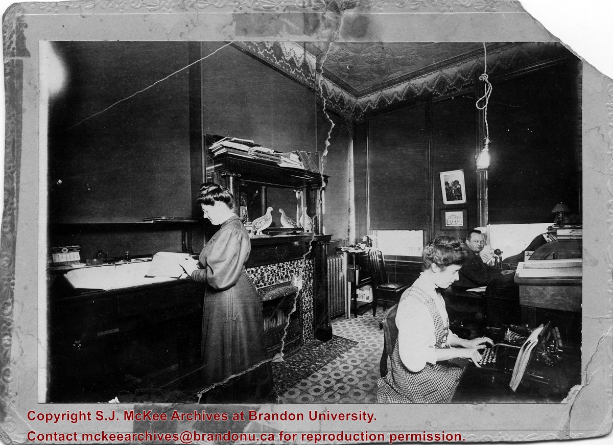
Lottie Louisa Currie was born on September 9, 1876 in St. Mary's, Perth, ON, to William and Eleanor Currie. She came to the Brandon area with her family in the 1880s. Currie worked as a bookkeeper and stenographer for Smith & Burton, from at least 1906 until the business ceased operations in 1917.
Currie continued working in bookkeeping and accounts, first for Brandon Gas & Power Co., then for the Manitoba Power Commission. She appears to have retired around 1942. She is not listed as living in Brandon between 1943-1945, but was once again a resident by 1947. Currie was a member of the First Presbyterian Church, a charter member of the Brandon Business and Professional Women's Club and in 1916, she passed her examinations for the St. John's Ambulance Association.
Lottie Louisa Currie died on November 25, 1972 in Brandon, MB.
Smith & Burton, a grocery store that also had mail order and china departments, was founded by E.B. Smith and John Burton in the 1886. It was housed at a few locations in downtown Brandon; their location at 829 Rosser Avenue is the one that mostly likely appears in the photograph.
Scope and Content
Item is a portrait of office employees at Smith & Burton, grocers. Lottie Currie, daughter of William Currie, is shown standing on the left.
Photograph shows the 700-block of Rosser Avenue facing west. Visible businesses on the north side of Rosser Avenue include: Burchill's Music Store, E.W. Woolworth Co. Ltd. 5-10 and 15 Cent Store in the E.E. Evans Block, Empire Hotel, and W.A. Paterson Drugs. Automobiles are parked on both sides of the avenue and at the time the photograph was taken, Rosser Avenue was a two-way street.
Notes
Part of "Souvenir of Brandon, Manitoba, Canada [viewbook], Printed by Photogelatine Engraving Co. Limited, Ottawa." Dates obtained from the Burchill's Music Store Henderson's Brandon City Directory listings (1927-1929). Writing on the front of the photograph reads: Rosser St. [sic.] - Brandon, Man.
For custodial history see the collection level description of the Lawrence Stuckey collection.
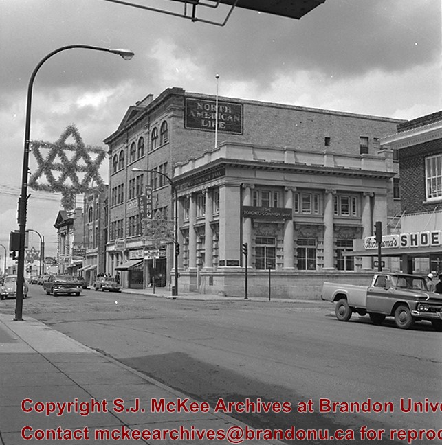
Scope and Content
1000 block of Rosser Ave., north side. Showing (left to right): Public Library (ex. Merchants Bank of Canada) built 1906; [Smith's Tobacco Shop,]; A.C. Fraser Block built 1890; Scotia Towers built 1970's.
For custodial history see the collection level description of the Lawrence Stuckey collection.
Scope and Content
1000 block of Rosser Ave., north side. Showing (left to right): Public Library (ex. Merchants Bank of Canada) built 1906; [Smith's Tobacco Shop,]; A.C. Fraser Block built 1890; Scotia Towers built 1970's.
Photograph shows a street view of 10th Street facing north. There are many automobiles parked along the street and several pedestrians in summer dress are on the sidewalks and street. Visible business signs include: Hentzman & Co. Pianos (possibly belonging to J.J.H. McLean Co. Ltd.), the Strand Theatre, T & D Clothes, Campbell & Campbell, the CPR Station, and Bowling Alley and Billiards.
Notes
Part of "Souvenir of Brandon, Manitoba, Canada [viewbook], Printed by Photogelatine Engraving Co. Limited, Ottawa." Dates obtained from the Burchill's Music Store Henderson's Brandon City Directory listings (1927-1929). Writing on the front of the photograph reads: 10th St., looking north (C.P.R. Station at end of Street) Brandon, Man.
Photograph shows the Red Indian (Gasoline) Station on the north side Princess Avenue between 9th and 10th Streets, Brandon. Attached to the west side of the gas station is another shop which contains Hutchings' Drug Store. The Alexandra Block on 10th Street is visible in the background.
Photograph shows the Greyhound Bus Depot at 11th Street and Princess Avenue. Western Motors, Wheelers Esso Station, and the Prince Edward Hotel are visible along the south side of Princess Avenue. Traffic is travelling one-way on Princess Avenue.
Photograph shows Princess Avenue facing east from 10th Street. On the north side of Princess Avenue, a B/A Service Station, Princess Cafe, Lindenberg Seeds, and the Central Fire Station are visible. Old City Hall with the war memorial and the Prince Edward Hotel are visible on the south side of Princess Avenue. Traffic is travelling one-way on Princess Avenue.
Photograph shows the west side of the 200-block on 10th Street. Visible businesses include: Chamber of Commerce Tourist Information, Dominion Tire & Radio Co., Bonnie's Bonnet Shop, Steve's Grill, Wally's Taxi, and Western Motors Ltd. The painted advertisement for Doig, Rankin and Robertson is visible on the Alexandra Block. Christmas ornaments are displayed from light standards and include Santa Claus and a Christmas elf.
Photograph shows the west side of the 200-block on 10th Street. Visible businesses include: Chamber of Commerce Tourist Information, Dominion Tire & Radio Co., Steve's Grill, Wally's Taxi, and the garage entrances to Western Motors Ltd. A Santa Claus Christmas ornament is displayed from a light standard.
The McKee Archives is the copyright holder for the Stuckey materials.
Storage Location
Lawrence Stuckey collection
Arrangement
[Mr. Stuckey put 8 negatives in the same envelope, numbered 1 through 10 (negatives 3 and 4 are missing). We have separated them, keeping their original numbers.]


.jpg?width=1200&404=no-img.jpg&watermark=wmk)
.jpg?width=180&404=no-img.jpg)
.jpg?width=1200&404=no-img.jpg&watermark=wmk)
.jpg?width=180&404=no-img.jpg)


.jpg?width=1200&404=no-img.jpg&watermark=wmk)
.jpg?width=180&404=no-img.jpg)
.jpg%3fmaxheight%3d1000%26maxwidth%3d1000%26watermark%3dwmk&description=1000+block+of+Rosser+Avenue)
.jpg%3fmaxheight%3d1000%26maxwidth%3d1000%26watermark%3dwmk&description=1000+block+of+Rosser+Avenue)
+north+side+Princess+Avenue+between+9th+Street+and+10th+Street%2c+Brandon%2c+Manitoba)
.jpg%3fmaxheight%3d1000%26maxwidth%3d1000%26watermark%3dwmk&description=Brandon+from+roof+of+Christie+Building)