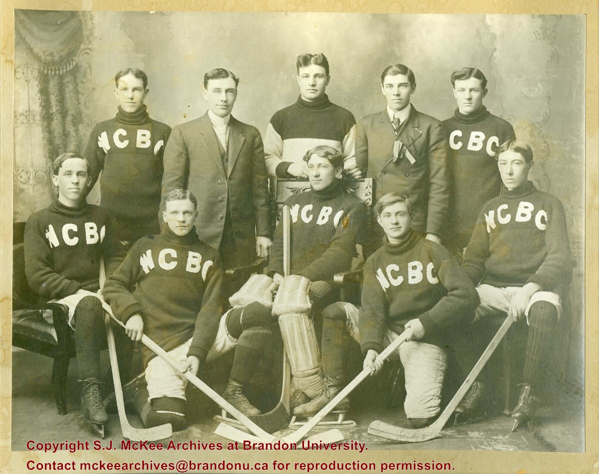
Photograph shows a group of 10 men, eight whom are wearing sweaters with the letters WCBC appliqued across the chest. The goalie is seated in a wodden chair and wears his goalie pads and skates. The four other players in the front row are also wearing skates and have their hockey sticks.
Notes
Writing on the front of the photograph mat reads: Wheat City Business College Hockey Club, 1912
Brandon College established a Canadian Officer Training Corps (COTC) program in 1916 and had enough students for a platoon that would join the 196th Western Universities Battalion's B Company. COTC logs for in the SJ McKee Archives show that at least 40 men regularly attended classes on campus during the 1916 winter term.
The Brandon Daily Sun published the names of 60 potential platoon recruits before they headed to Camp Hughes to train in the summer of 1916. Although Lt. J.R.C. Evans spearheaded the training of the COTC enlistees at Brandon College, he was found medically unfit for overseas service. In his stead, the son of the college's founder, Lt. William Carey McKee, lead the platoon to Camp Hughes where they joined the 196th Battalion. Of the 60 recruits identified in the local paper, 20 would not survive the war, including Lt. McKee. [ST/2016]
Scope and Content
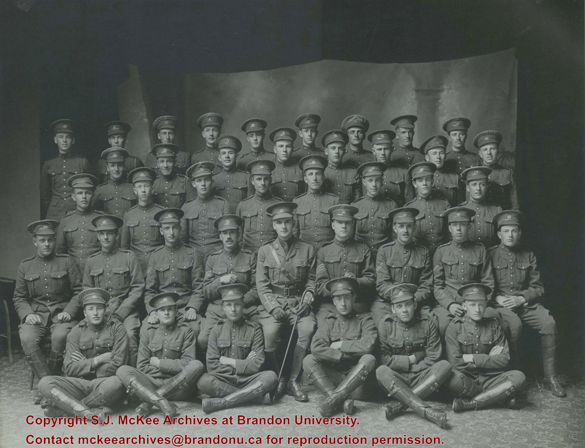
Photograph shows a group of 40 men wearing WWI uniforms. The men have the Canada general service cap badge on their headdress. The officer in the centre of the group (i.e., the man with the cane) is J.R.C. Evans. The group of men are likely members of the first Brandon College Platoon, which joined the 196th Western Universities Battalion.
Photograph is looking northwest probably from the northwest corner of 18th Street and Louise Avenue. The photographer was laying down when s/he took the shot. Photograph shows the field to the south of the Citizens' Science Building, as well as the Citizens' Science Building, part of the Brandon College Building and Clark Hall, and two H-Huts. The photo was taken in summer as the field is full of dandelions.
View is southwest. Photograph shows Clark Hall, the Brandon College Building, the Citizens' Science Building and the driveway running in front of the buildings. Portions of the front lawn and the Kinsmen Staduim are also visible.
View is northwest from the front lawn. Photograph shows the Citizens' Science Building, an H-Hut, the Brandon College Building, Clark Hall and the original Music Building.
View is south southwest from approximatley the location of the current Health Studies Complex. Photograph shows the large field to the north of Clark Hall, Clark Hall, the Brandon College Building, the Citizens' Science Building and an H-Hut behind Clark Hall.
A problem during development has obscured a portion of Kinsmen Stadium and the southeast corner of the campus.
Scope and Content
View is north from Victoria Avenue between 18th and 20th Streets to the railway tracks. Photograph shows Kinsmen Stadium, the College campus and a number of residential blocks.
View is northeast from approximately the southwest corner of Victoria Avenue and 22nd Street to the Assiniboine River near 1st Street. Photograph shows the College campus, Kinsmen Stadium, residential blocks, downtown and the railway tracks.
View is northwest from the 400 block of 18th Street to the corner of 23rd Street and Rosser Avenue. Photograph shows the Brandon College campus (Flora Cowan Hall under construction) and residential blocks.
View is southwest from the north side of Princess Avenue. Photograph shows the north driveway entrance on campus. The original Music Building, the A.E. McKenzie Building, Clark Hall and part of the Brandon College Building are visible.
View is north northeast. Photograph shows the Brandon College Building in the foreground with the Education Building and North Hill in the background. Photo was taken from the roof of McMaster Hall.
View is northwest from approximately the corner of 18th Street and Louise Avenue. Photograph shows the Brandon College campus after the completion of Flora Cowan Hall.
Notes
BUPC 2.1.24 is a smaller version of this photograph.
View is west northwest, probably from the roof of the Brandon College Building. Photograph shows an ice skating rink located in the field west of the Brandon College Building and Clark Hall. Some houses are visible in the background.
View is west to McDiarmid Drive from approximately 16th Street between Princess and Louise Avenues. Photograph shows: Brandon College, Fleming School, Coronation Park, and West End Community Centre.
View is northwest from the corner of 18th Street and Louise Avenue. Photograph shows the Brandon College campus, the Steam Plant and Kinsmen Stadium. Flora Cowan Hall is under construction.
View is east southeast from approximately 22nd Street between Princess and Louise Avenues. Photograph shows: Brandon College, Stanley Park, Park School, Prince Edward Hotel, First Baptist Church, First Presbyterian Church, Wheat City Arena, First Church United, St. Paul's, Central United Church.
View is southeast from 21st Street and Princess Avenue. Photograph shows: Brandon College, Wheat City Arena, Armories, Reform (Knox) Church, Alexander School, Knox United Church, Kinsmen Playground, Kinsmen Stadium.


