Skip header and navigation

Revise Search

48 records – page 1 of 3.

Aerial view: Brandon College

http://archives.brandonu.ca/en/permalink/descriptions594
Part Of
Brandon University Photograph collection
Description Level
Item
GMD
graphic
Date Range
[fall 1964?]
Part Of
Brandon University Photograph collection
Description Level
Item
Series Number
2.1
Item Number
BUPC 2.1.2
GMD
graphic
Date Range
[fall 1964?]
Physical Description
5" x 4" (b/w)
Scope and Content
Brandon College looking south from 19th Street. Photograph was taken after Flora Cowan Hall was built but before construction of the Education Building.
Subject Access
aerial photographs
campus photographs
campus buildings
Brandon streets
Images
Show Less

Aerial view - Brandon College looking southwest

http://archives.brandonu.ca/en/permalink/descriptions601
Part Of
Brandon University Photograph collection
Description Level
Item
GMD
graphic
Date Range
[1963-1966]
Part Of
Brandon University Photograph collection
Description Level
Item
Series Number
2.1
Item Number
BUPC 2.1.8
GMD
graphic
Date Range
[1963-1966]
Physical Description
5" x 4" (b/w)
Scope and Content
Image shows the Brandon College campus from 17th Street looking southwest. The photo was taken after the completion of the original Music Building in 1963, but construction of the Education Building. Also visible are a number of properties on the 200 block of 18th Street and the 200 block of 20th Street.
Subject Access
aerial photographs
campus photographs
campus buildings
Brandon streets
Images
Show Less

Aerial view: Brandon College from 23rd Street

http://archives.brandonu.ca/en/permalink/descriptions602
Part Of
Brandon University Photograph collection
Description Level
Item
GMD
graphic
Date Range
[1963-1966]
Part Of
Brandon University Photograph collection
Description Level
Item
Series Number
2.1
Item Number
BUPC 2.1.9
GMD
graphic
Date Range
[1963-1966]
Physical Description
5" x 4" (b/w)
Scope and Content
Image is looking east northeast from approximately the 300 block of 23rd Street between Lorne and Louise Avenues. Photograph shows the Brandon College campus after the opening of the original Music Building in 1963, but before the construction of the Education Building in 1966. A number of house on the 300 blocks of 22nd and 21st Streets are visible in the foreground, with the A.E. McKenzie Seed Co., the Prince Edward Hotel and various grain elevators on the horizon.
Subject Access
aerial photographs
campus photographs
campus buildings
Brandon streets
Grain elevators
Images
Show Less

Curries Landing (Assiniboine River)

http://archives.brandonu.ca/en/permalink/descriptions11132
Part Of
RG 11 Lawrence Stuckey fonds
Description Level
Item
GMD
graphic
Date Range
Apr. 12, 1977
Part Of
RG 11 Lawrence Stuckey fonds
Creator
L.A. Stuckey
Description Level
Item
Series Number
3.3
Item Number
1-2002.3.3.BSE[366a]
GMD
graphic
Date Range
Apr. 12, 1977
Physical Description
2.5" x 2.5"
Material Details
Negative
Custodial History
For custodial history see the collection level description of the Lawrence Stuckey collection.
Scope and Content
Image of Curries Landing (Assiniboine River).
Notes
[Brandon SE includes communities south of Trans-Canada #1 highway and east of PTH #10.]
Name Access
Curries Landing
Assiniboine River
Subject Access
Rivers
Storage Location
Lawrence Stuckey collection
Arrangement
[Mr. Stuckey put three negatives in the same envelope. We have separated them and numbered the negatives (366a) to(366c)].
Images
Show Less

Curries Landing (Assiniboine River)

http://archives.brandonu.ca/en/permalink/descriptions11134
Part Of
RG 11 Lawrence Stuckey fonds
Description Level
Item
GMD
graphic
Date Range
Apr. 12, 1977
Part Of
RG 11 Lawrence Stuckey fonds
Creator
L.A. Stuckey
Description Level
Item
Series Number
3.3
Item Number
1-2002.3.3.BSE[366b]
GMD
graphic
Date Range
Apr. 12, 1977
Physical Description
2.5" x 2.5"
Material Details
Negative
Custodial History
For custodial history see the collection level description of the Lawrence Stuckey collection.
Scope and Content
Image of Curries Landing (Assiniboine River).
Notes
[Brandon SE includes communities south of Trans-Canada #1 highway and east of PTH #10.]
Name Access
Curries Landing
Assiniboine River
Subject Access
Rivers
Storage Location
Lawrence Stuckey collection
Arrangement
[Mr. Stuckey put three negatives in the same envelope. We have separated them and numbered the negatives (366a) to(366c)].
Images
Show Less

Curries Landing (Assiniboine River)

http://archives.brandonu.ca/en/permalink/descriptions11135
Part Of
RG 11 Lawrence Stuckey fonds
Description Level
Item
GMD
graphic
Date Range
Apr. 12, 1977
Part Of
RG 11 Lawrence Stuckey fonds
Creator
L.A. Stuckey
Description Level
Item
Series Number
3.3
Item Number
1-2002.3.3.BSE[366c]
GMD
graphic
Date Range
Apr. 12, 1977
Physical Description
2.5" x 2.5"
Material Details
Negative
Custodial History
For custodial history see the collection level description of the Lawrence Stuckey collection.
Scope and Content
Image of Curries Landing (Assiniboine River).
Notes
[Brandon SE includes communities south of Trans-Canada #1 highway and east of PTH #10.]
Name Access
Curries Landing
Assiniboine River
Subject Access
Rivers
Storage Location
Lawrence Stuckey collection
Arrangement
[Mr. Stuckey put three negatives in the same envelope. We have separated them and numbered the negatives (366a) to(366c)].
Images
Show Less

British American dealers - aerial view looking north at intersection of Highways 1 and 10

http://archives.brandonu.ca/en/permalink/descriptions11240
Part Of
CKX fonds
Description Level
Item
GMD
graphic
Date Range
after 1954
Accession Number
11-2010
Part Of
CKX fonds
Creator
CKX
Description Level
Item
Item Number
11-2010.B3u
Accession Number
11-2010
GMD
graphic
Date Range
after 1954
Physical Description
5" x 4" (b/w)
Material Details
Negative
Custodial History
See fonds level of the CKX records for custodial history.
Scope and Content
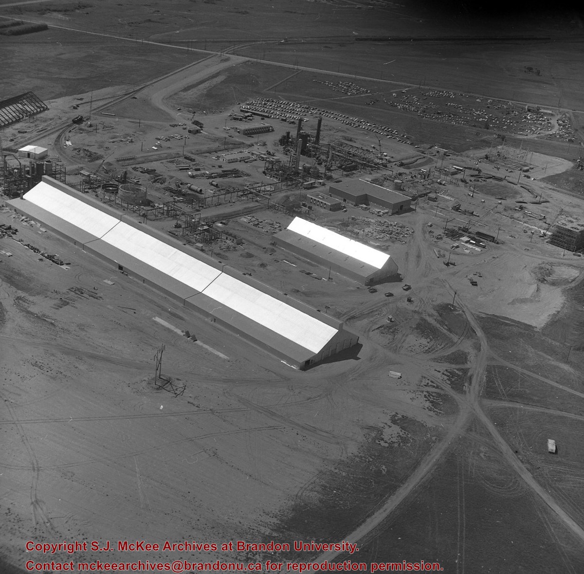
Image consists of an aerial view looking north at the intersection of Highways 1 and 10 and shows the British American dealer located at the intersection.
Name Access
CKX
British American Dealers
Brandon, Manitoba
Subject Access
aerial photographs
Storage Location
CKX fonds - 2010 accessions
Images
Show Less

British American dealers - aerial view looking southeast from intersection of Highways 1 and 10

http://archives.brandonu.ca/en/permalink/descriptions11242
Part Of
CKX fonds
Description Level
Item
GMD
graphic
Date Range
after 1954
Accession Number
11-2010
Part Of
CKX fonds
Creator
CKX
Description Level
Item
Item Number
11-2010.B3v
Accession Number
11-2010
GMD
graphic
Date Range
after 1954
Physical Description
5" x 4" (b/w)
Material Details
Negative
Custodial History
See fonds level of the CKX records for custodial history.
Scope and Content
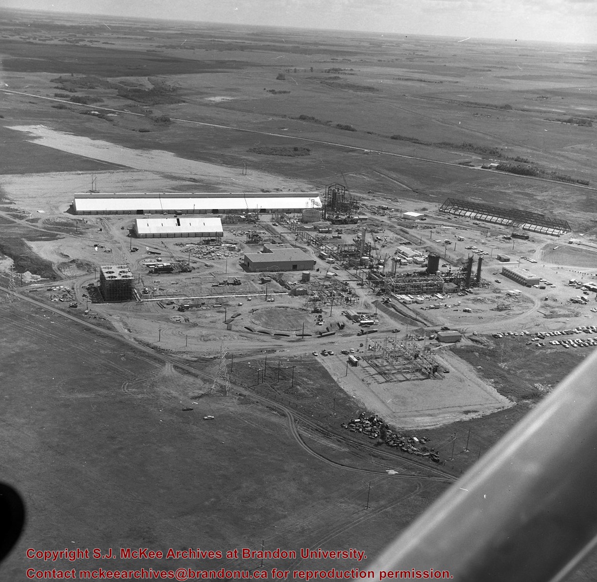
Image consists of an aerial view looking southeast at the intersection of Highways 1 and 10 and shows the British American dealer located at the intersection.
Name Access
CKX
British American Dealers
Brandon, Manitoba
Subject Access
aerial photographs
Storage Location
CKX fonds - 2010 accessions
Images
Show Less

British American dealers - aerial view looking northeast from intersection of Highways 1 and 10

http://archives.brandonu.ca/en/permalink/descriptions11243
Part Of
CKX fonds
Description Level
Item
GMD
graphic
Date Range
after 1954
Accession Number
11-2010
Part Of
CKX fonds
Creator
CKX
Description Level
Item
Item Number
11-2010.B3w
Accession Number
11-2010
GMD
graphic
Date Range
after 1954
Physical Description
5" x 4" (b/w)
Material Details
Negative
Custodial History
See fonds level of the CKX records for custodial history.
Scope and Content
Image consists of an aerial view looking northeast at the intersection of Highways 1 and 10 and shows the British American dealer located at the intersection.
Name Access
CKX
British American Dealers
Brandon, Manitoba
Subject Access
aerial photographs
Storage Location
CKX fonds - 2010 accessions
Images
Show Less
Part Of
CKX fonds
Description Level
Item
GMD
graphic
Date Range
1966
Accession Number
11-2010
Part Of
CKX fonds
Creator
CKX
Description Level
Item
Series Number
S
Item Number
11-2010.S152c
Accession Number
11-2010
GMD
graphic
Date Range
1966
Physical Description
2.5" x 2.5" (b/w)
Material Details
Negative
Custodial History
See fonds level of the CKX records for custodial history.
Scope and Content
Image of the Simplot grounds.
Name Access
CKX
Simplot
Subject Access
aerial photographs
commerical buildings
industries
building exteriors
cars
Storage Location
CKX fonds - 2010 accessions
Images
Show Less
Part Of
CKX fonds
Description Level
Item
GMD
graphic
Date Range
1966
Accession Number
11-2010
Part Of
CKX fonds
Creator
CKX
Description Level
Item
Series Number
S
Item Number
11-2010.S152b
Accession Number
11-2010
GMD
graphic
Date Range
1966
Physical Description
2.5" x 2.5" (b/w)
Material Details
Negative
Custodial History
See fonds level of the CKX records for custodial history.
Scope and Content
Image of the Simplot grounds.
Name Access
CKX
Simplot
Subject Access
aerial photographs
commerical buildings
industries
building exteriors
cars
Storage Location
CKX fonds - 2010 accessions
Images
Show Less
Part Of
CKX fonds
Description Level
Item
GMD
graphic
Date Range
1966
Accession Number
11-2010
Part Of
CKX fonds
Creator
CKX
Description Level
Item
Series Number
S
Item Number
11-2010.S152a
Accession Number
11-2010
GMD
graphic
Date Range
1966
Physical Description
2.5" x 2.5" (b/w)
Material Details
Negative
Custodial History
See fonds level of the CKX records for custodial history.
Scope and Content
Image of the Simplot grounds.
Name Access
CKX
Simplot
Subject Access
aerial photographs
commerical buildings
industries
building exteriors
cars
Storage Location
CKX fonds - 2010 accessions
Images
Show Less
Part Of
CKX fonds
Description Level
Item
GMD
graphic
Date Range
after 1954
Accession Number
11-2010
Part Of
CKX fonds
Creator
CKX
Description Level
Item
Series Number
S
Item Number
11-2010.S116k
Accession Number
11-2010
GMD
graphic
Date Range
after 1954
Physical Description
5" x 4" (b/w)
Material Details
Negative
Custodial History
See fonds level of the CKX records for custodial history.
Scope and Content
Image of the Assiniboine River.
Name Access
CKX
Assiniboine River
Subject Access
winter
Rivers
bridges
building exteriors
trees
Storage Location
CKX fonds - 2010 accessions
Images
Show Less
Part Of
CKX fonds
Description Level
Item
GMD
graphic
Date Range
after 1954
Accession Number
11-2010
Part Of
CKX fonds
Creator
CKX
Description Level
Item
Series Number
S
Item Number
11-2010.S116j
Accession Number
11-2010
GMD
graphic
Date Range
after 1954
Physical Description
5" x 4" (b/w)
Material Details
Negative
Custodial History
See fonds level of the CKX records for custodial history.
Scope and Content
Image of people swimming in the Assiniboine River.
Name Access
CKX
Assiniboine River
Subject Access
Rivers
building exteriors
persons
swimming
cars
Storage Location
CKX fonds - 2010 accessions
Images
Show Less
Part Of
CKX fonds
Description Level
Item
GMD
graphic
Date Range
1968
Accession Number
11-2010
Part Of
CKX fonds
Creator
CKX
Description Level
Item
Series Number
S
Item Number
11-2010.S31b
Accession Number
11-2010
GMD
graphic
Date Range
1968
Physical Description
1.5" x 1.5" (b/w)
Material Details
Negative
Custodial History
See fonds level of the CKX records for custodial history.
Scope and Content
Image of the St.Lazar bridge.
Name Access
CKX
Subject Access
bridges
signs and signboards
Rivers
Storage Location
CKX fonds - 2010 accessions
Images
Show Less
Part Of
CKX fonds
Description Level
Item
GMD
graphic
Date Range
1968
Accession Number
11-2010
Part Of
CKX fonds
Creator
CKX
Description Level
Item
Series Number
S
Item Number
11-2010.S31a
Accession Number
11-2010
GMD
graphic
Date Range
1968
Physical Description
1.5" x 1.5" (b/w)
Material Details
Negative
Custodial History
See fonds level of the CKX records for custodial history.
Scope and Content
Image of the St.Lazar bridge.
Name Access
CKX
Subject Access
bridges
Rivers
trees
Storage Location
CKX fonds - 2010 accessions
Images
Show Less

Steam plant - construction

http://archives.brandonu.ca/en/permalink/descriptions13298
Part Of
CKX fonds
Description Level
Item
GMD
graphic
Date Range
after 1954
Accession Number
11-2010
Part Of
CKX fonds
Creator
CKX
Description Level
Item
Series Number
S
Item Number
11-2010.S4a
Accession Number
11-2010
GMD
graphic
Date Range
after 1954
Physical Description
1.5" x 1.5" (b/w)
Material Details
Negative
Custodial History
See fonds level of the CKX records for custodial history.
Scope and Content
Image of the steam plant under construction.
Name Access
CKX
Subject Access
construction
commercial buildings
construction equipment
employees
aerial photographs
Storage Location
CKX fonds - 2010 accessions
Images
Show Less
Part Of
Fred McGuinness collection
Description Level
Item
GMD
graphic
Date Range
1900-1924
Part Of
Fred McGuinness collection
Description Level
Item
Series Number
McG 9
Item Number
20-2009.26
GMD
graphic
Date Range
1900-1924
Physical Description
4.25" x 2.5" (b/w)
History / Biographical
Situated in the R.M. of Whitehead on the Little Saskatchewan River, the 10 Mile Dam was a 14 kilometer transmission line that supplied the city of Brandon with power. The Brandon Electric Light Company built the dam in 1900 and it is considered Manitoba's first hydroelectic power generating station. The dam spanned approximately 80 meters and was constructed from timber and reinforced with clay and stone. The station was decommissioned in 1924.
Scope and Content
Photograph shows 10 Mile Dam, also known as the Brandon Dam or Minnedosa River Hydro Plant.
Notes
Writing on the back of the photograph reads: "10 mile dam". Biographical information obtained from Manitoba Historical Society.
Name Access
10 Mile Dam
Ten Mile Dam
Brandon Dam
Minnedosa River Hydro Plant
Brandon Electric Light Company
Little Saskatchewan River
Subject Access
dams
Rivers
hydroelectric dams
hydroelectric generation
Storage Location
RG 5 photograph storage drawer 2 (hanging photos)
Images
Show Less

Fishing at 10 Mile Dam

http://archives.brandonu.ca/en/permalink/descriptions13731
Part Of
Fred McGuinness collection
Description Level
Item
GMD
graphic
Date Range
1906?
Accession Number
20-2009
Part Of
Fred McGuinness collection
Description Level
Item
Series Number
McG 9
Item Number
20-2009.41
Accession Number
20-2009
GMD
graphic
Date Range
1906?
Physical Description
6.5" x 4.75" (b/w)
Material Details
reproduction
History / Biographical
Situated in the R.M. of Whitehead on the Little Saskatchewan River, the 10 Mile Dam was a 14 kilometer transmission line that supplied the city of Brandon with power. The Brandon Electric Light Company built the dam in 1900 and it is considered Manitoba's first hydroelectic power generating station. The dam spanned approximately 80 meters and was constructed from timber and reinforced with clay and stone. The station was decommissioned in 1924. Alonzo Archibald Rowe (b. 1862, London, ON; d. 22 Oct 1951, Brandon). The Rowes were considered Brandon area pioneers. Alonzo’s father, Alonzo L. Rowe, came to Brandon with his family in 1881, where the family had a furniture and undertaker business on the west side of 10th Street between Rosser and Princess Avenues. In 1885, the family began farming west of Brandon and Alonzo Archibald served as a councilor and then a reeve in the R.M. of Whitehead. He returned to Brandon in 1907 and served with the Brandon Police Department until 1910, when he returned to farming, this time in Arrow River. A.A. Rowe returned to Brandon in 1915 to work as a Provincial Licenses Inspector, a position he held until 1938. (Source: Obituary, Brandon Daily Sun 22 Oct 1951)
Custodial History
Photograph was in possession of Mrs. Ruby Miles, who passed the image on to Fred McGuinness. McGuinness makes reference to Mrs. Miles and this photograph in his Sunbeams column (Source: F.A. Rosser, "Another interesting chat with a daughter of the plains," Brandon Sun 18 Aug 1981).
Scope and Content
Photograph shows four fishermen at 10 Mile Dam, also known as the Brandon Dam or Minnedosa River Hydro Plant. The fishermen in the photo are identified as George H. Rowe and his father A.A. Rowe, Dr. Wilfred Bigelow, and Al Collins.
Notes
Writing on the back of the photograph reads: at Brandon Dam, [right to left] son and father - George H. ROWE, Mr. A.A. ROWE, Dr. BIGELOW, Al COLLINS (dam?, 1906?, George born March 1897); Jerrett's Photo-Services, May 7 1938.
Name Access
10 Mile Dam
Ten Mile Dam
Brandon Dam
Minnedosa River Hydro Plant
Brandon Electric Light Company
Little Saskatchewan River
George H. Rowe
A.A. Rowe
Dr. Bigelow
Al Collins
Subject Access
dams
Rivers
fishing
Storage Location
RG 5 photograph storage drawer 2 (hanging photos)
Related Material
Ruby Miles collection 14-2003
Images
Show Less

Morning reflection of Brandon's skyline on the Assiniboine River

http://archives.brandonu.ca/en/permalink/descriptions13781
Part Of
Fred McGuinness collection
Description Level
Item
GMD
graphic
Date Range
[1980s]
Accession Number
20-2009
Part Of
Fred McGuinness collection
Creator
Photographer: Sandy Black
Description Level
Item
Series Number
McG 9
Item Number
20-2009.92
Accession Number
20-2009
GMD
graphic
Date Range
[1980s]
Physical Description
5.5" x 3.5" (colour)
Material Details
postcard
Scope and Content
Postcard shows the 100 block of 10th Street facing north. The CPR train station can be seen at the end of 10th Street. The sign for the Rex Cafe is visible on the west side of 10th Street. On the east side of 10th Street, billboards for Campbell & Campbell furniture are visible as well as signs for Pianos and the Orpheum Theatre. Motorists and cyclists share the road. Street car tracks run the length of 10th Street.
Notes
Back of postcard reads: Morning reflection of Brandon's skyline on the Assiniboine River, photo by Sandy Black, printed in Brandno, Manitoba, Canada by Leech Printing Ltd.
Name Access
Assiniboine River
McKenzie Seeds
Scotia Towers
Subject Access
Rivers
downtown
Storage Location
RG 5 photograph storage drawer 2 (hanging photos)
Images
Show Less

48 records – page 1 of 3.