Skip header and navigation

Revise Search

20 records – page 3 of 1.

Curries Landing (Assiniboine River)

http://archives.brandonu.ca/en/permalink/descriptions11134
Part Of
RG 11 Lawrence Stuckey fonds
Description Level
Item
GMD
graphic
Date Range
Apr. 12, 1977
Part Of
RG 11 Lawrence Stuckey fonds
Creator
L.A. Stuckey
Description Level
Item
Series Number
3.3
Item Number
1-2002.3.3.BSE[366b]
GMD
graphic
Date Range
Apr. 12, 1977
Physical Description
2.5" x 2.5"
Material Details
Negative
Custodial History
For custodial history see the collection level description of the Lawrence Stuckey collection.
Scope and Content
Image of Curries Landing (Assiniboine River).
Notes
[Brandon SE includes communities south of Trans-Canada #1 highway and east of PTH #10.]
Name Access
Curries Landing
Assiniboine River
Subject Access
Rivers
Storage Location
Lawrence Stuckey collection
Arrangement
[Mr. Stuckey put three negatives in the same envelope. We have separated them and numbered the negatives (366a) to(366c)].
Images
Show Less

Curries Landing (Assiniboine River)

http://archives.brandonu.ca/en/permalink/descriptions11135
Part Of
RG 11 Lawrence Stuckey fonds
Description Level
Item
GMD
graphic
Date Range
Apr. 12, 1977
Part Of
RG 11 Lawrence Stuckey fonds
Creator
L.A. Stuckey
Description Level
Item
Series Number
3.3
Item Number
1-2002.3.3.BSE[366c]
GMD
graphic
Date Range
Apr. 12, 1977
Physical Description
2.5" x 2.5"
Material Details
Negative
Custodial History
For custodial history see the collection level description of the Lawrence Stuckey collection.
Scope and Content
Image of Curries Landing (Assiniboine River).
Notes
[Brandon SE includes communities south of Trans-Canada #1 highway and east of PTH #10.]
Name Access
Curries Landing
Assiniboine River
Subject Access
Rivers
Storage Location
Lawrence Stuckey collection
Arrangement
[Mr. Stuckey put three negatives in the same envelope. We have separated them and numbered the negatives (366a) to(366c)].
Images
Show Less

Assiniboine Avenue - Early Scene

http://archives.brandonu.ca/en/permalink/descriptions9207
Part Of
RG 11 Lawrence Stuckey fonds
Description Level
Item
GMD
graphic
Date Range
[ca. 1890]
Accession Number
1-2002
Part Of
RG 11 Lawrence Stuckey fonds
Creator
Irwin
Description Level
Item
Series Number
3.1
Item Number
1-2002.3.1C19
Accession Number
1-2002
GMD
graphic
Date Range
[ca. 1890]
Physical Description
2 1/2" x 3 1/2"
Material Details
Negative
Custodial History
For custodial history see the collection level description of the Lawrence Stuckey collection.
Scope and Content
View of Assiniboine Avenue running west, from Ninth Street North
Notes
Second building from right - Westbrook & Fairchild Implements. At left - Western Hotel; Data [courtesy of] Roy Brown from Henderson's [Directory]; From Manitoba Archives
Name Access
Assiniboine Avenue - Early Scene
Subject Access
downtowns
businesses
agricultural buildings
hotels
Brandon Street Scenes Before 1940
Repro Restriction
The McKee Archives is the copyright holder for the Stuckey materials.
Storage Location
Lawrence Stuckey collection
Images
Show Less

Junction of the Syne River and Assiniboine River

http://archives.brandonu.ca/en/permalink/descriptions6516
Part Of
Alf Fowler collection
Description Level
Item
GMD
graphic
Date Range
ca. 1911
Accession Number
6-1999
Part Of
Alf Fowler collection
Creator
Davidson & Gowen
Description Level
Item
Item Number
6-1999.92
Accession Number
6-1999
GMD
graphic
Date Range
ca. 1911
Physical Description
9.25" x 7.25" (b/w)
Custodial History
See fonds level description of the Alf Fowler collection for custodial history.
Scope and Content
Photo shows the junction of the Syne and Assiniboine Rivers
Storage Range
RG 5 Western Manitoba Manuscript collection - photograph storage drawer
Images
Show Less
Part Of
CKX fonds
Description Level
Item
GMD
graphic
Date Range
after 1954
Accession Number
11-2010
Part Of
CKX fonds
Creator
CKX
Description Level
Item
Item Number
11-2010.B74f(1) and (2)
Accession Number
11-2010
GMD
graphic
Date Range
after 1954
Physical Description
2 negatives - each 2.25" x 2.25" (b/w)
Material Details
Negative
Custodial History
See fonds level of the CKX records for custodial history.
Scope and Content
Images of the Thompson Bridge.
Notes
Negatives incorrectly identified as Brandon 18th Street overpass construction by CKX.
Name Access
CKX Television
Thompson Bridge
Subject Access
bridges
construction of bridges
Storage Location
CKX fonds - 2010 accessions
Images
Show Less
Part Of
CKX fonds
Description Level
Item
GMD
graphic
Date Range
1968
Accession Number
11-2010
Part Of
CKX fonds
Creator
CKX
Description Level
Item
Series Number
S
Item Number
11-2010.S31b
Accession Number
11-2010
GMD
graphic
Date Range
1968
Physical Description
1.5" x 1.5" (b/w)
Material Details
Negative
Custodial History
See fonds level of the CKX records for custodial history.
Scope and Content
Image of the St.Lazar bridge.
Name Access
CKX
Subject Access
bridges
signs and signboards
Rivers
Storage Location
CKX fonds - 2010 accessions
Images
Show Less
Part Of
CKX fonds
Description Level
Item
GMD
graphic
Date Range
1968
Accession Number
11-2010
Part Of
CKX fonds
Creator
CKX
Description Level
Item
Series Number
S
Item Number
11-2010.S31a
Accession Number
11-2010
GMD
graphic
Date Range
1968
Physical Description
1.5" x 1.5" (b/w)
Material Details
Negative
Custodial History
See fonds level of the CKX records for custodial history.
Scope and Content
Image of the St.Lazar bridge.
Name Access
CKX
Subject Access
bridges
Rivers
trees
Storage Location
CKX fonds - 2010 accessions
Images
Show Less
Part Of
Fred McGuinness collection
Description Level
Item
GMD
graphic
Date Range
[19--]
Accession Number
20-2009
Other Title Info
Formerly called "bridge over Souris River?"
Part Of
Fred McGuinness collection
Description Level
Item
Series Number
McG 9
Item Number
20-2009.100
Accession Number
20-2009
GMD
graphic
Date Range
[19--]
Physical Description
10" x 8" (b/w)
History / Biographical
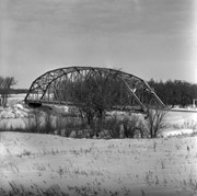
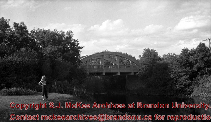
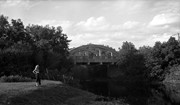
Kirkham's Bridge was built in 1906, to replace an earlier wooden bridge. The bridge was used until 1981, when it was purchased by the Town of Birtle and moved to a newsite. A former railway pridge was installed in its place.
Scope and Content
Photograph shows Kirkham's Bridge, a steel truss bridge that spanned the Little Saskatchewan River in the Municipality of Riverdale.
Notes
Identification of the bridge provided by Ken Storie (2023). Additional information taken from the Manitoba Historical Society website.
Subject Access
bridges
Rivers
Storage Location
RG 5 photograph storage drawer 2 (hanging photos)
Images
Show Less
Part Of
RG 11 Lawrence Stuckey fonds
Description Level
Item
GMD
graphic
Date Range
c. 1933
Accession Number
1-2002
Part Of
RG 11 Lawrence Stuckey fonds
Description Level
Item
Series Number
3.9
Item Number
1-2002.3.9.102
Accession Number
1-2002
GMD
graphic
Date Range
c. 1933
Physical Description
10" x 6.25" (b/w)
History / Biographical
Stuckey's notes: Contract for concrete approach from north end to replace east and west timber approaches along Assiniboine Ave. awarded to A.E. Jones and E. Fulcher for $30,590. Oct. 11, 1934. (Brandon Sun). As part of this project a Z-shaped ramp on the west side to Assiniboine Ave for pedestrians replaced wooden stairs to north end. G. Crighton Collection.
Scope and Content
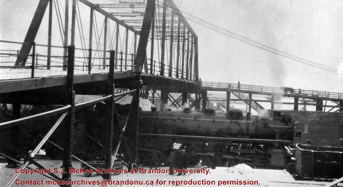
Photograph was taken from the east side of Pacific Avenue and shows the pedestrian stairway to the North end and a CPR early 2800 being serviced in Train No. 4.
Notes
Corresponds with negative 1-2002.3.9.BF2.
Repro Restriction
The McKee Archives is the copyright holder for the Stuckey materials.
Location Original
1-2002.3.1BF2
Storage Location
RG 5 photograph storage drawer
Images
Show Less
Part Of
RG 11 Lawrence Stuckey fonds
Description Level
Item
GMD
graphic
Date Range
January 22, 1979
Accession Number
1-2002
Part Of
RG 11 Lawrence Stuckey fonds
Creator
L.A. Stuckey
Description Level
Item
Series Number
3.1
Item Number
1-2002.3.1OB6
Accession Number
1-2002
GMD
graphic
Date Range
January 22, 1979
Physical Description
2 1/2" x 2 1/2"
Material Details
Negative
Custodial History
For custodial history see the collection level description of the Lawrence Stuckey collection.
Scope and Content
Halls' Bridge
Notes
Located on Provincial Trunk Highway 21, north of Griswold
Name Access
Halls' Bridge
Subject Access
manmade geographic features
bridges
Brandon Area Bridges
Repro Restriction
The McKee Archives is the copyright holder for the Stuckey materials.
Storage Location
Lawrence Stuckey collection
Images
Show Less

New Culvert and Causeway Across Assiniboine River

http://archives.brandonu.ca/en/permalink/descriptions9918
Part Of
RG 11 Lawrence Stuckey fonds
Description Level
Item
GMD
graphic
Date Range
May 23, 1989
Accession Number
1-2002
Part Of
RG 11 Lawrence Stuckey fonds
Creator
L.A. Stuckey
Description Level
Item
Series Number
3.1
Item Number
1-2002.3.1OB4(1)
Accession Number
1-2002
GMD
graphic
Date Range
May 23, 1989
Physical Description
2 1/2" x 2 1/2"
Material Details
Negative
History / Biographical
Causeway was basically complete by this date; Opening made for spring runoff (noted 3/18/90).
Custodial History
For custodial history see the collection level description of the Lawrence Stuckey collection.
Scope and Content
New culvert and causeway across Assiniboine River
Notes
See correspondence with Len Evans MLA; [Mr. Stuckey put two negatives in same envelope. We have separated and numbered them OB4(1) and OB4(2).]
Name Access
New Culvert and Causeway Across Assiniboine River
Subject Access
water control
drainage
manmade geographic features
causeways
culverts
Brandon Area Bridges
Repro Restriction
The McKee Archives is the copyright holder for the Stuckey materials.
Storage Location
Lawrence Stuckey collection
Images
Show Less

New Culvert and Causeway Across Assiniboine River

http://archives.brandonu.ca/en/permalink/descriptions9919
Part Of
RG 11 Lawrence Stuckey fonds
Description Level
Item
GMD
graphic
Date Range
May 23, 1989
Accession Number
1-2002
Part Of
RG 11 Lawrence Stuckey fonds
Creator
L.A. Stuckey
Description Level
Item
Series Number
3.1
Item Number
1-2002.3.1OB4(2)
Accession Number
1-2002
GMD
graphic
Date Range
May 23, 1989
Physical Description
2 1/2" x 2 1/2"
Material Details
Negative
History / Biographical
Causeway was basically complete by this date; Opening made for spring runoff (noted 3/18/90).
Custodial History
For custodial history see the collection level description of the Lawrence Stuckey collection.
Scope and Content
New culvert and causeway across Assiniboine River
Notes
See correspondence with Len Evans MLA; [Mr. Stuckey put two negatives in same envelope. We have separated and numbered them OB4(1) and OB4(2).]
Name Access
New Culvert and Causeway Across Assiniboine River
Subject Access
water control
drainage
manmade geographic features
causeways
culverts
Brandon Area Bridges
Repro Restriction
The McKee Archives is the copyright holder for the Stuckey materials.
Storage Location
Lawrence Stuckey collection
Images
Show Less

Assiniboine River; Treesbank Ferry - Stockton Ferry

http://archives.brandonu.ca/en/permalink/descriptions11023
Part Of
RG 11 Lawrence Stuckey fonds
Description Level
Item
GMD
graphic
Date Range
May 23, 1981
Part Of
RG 11 Lawrence Stuckey fonds
Creator
L.A. Stuckey
Description Level
Item
Series Number
3.3
Item Number
1-2002.3.3.BSE[362a]
GMD
graphic
Date Range
May 23, 1981
Physical Description
2.5" x 2.5"
Material Details
Negative
History / Biographical
Mr. Stuckey's notes: Jacques Wendover and Errol Bredin.
Custodial History
For custodial history see the collection level description of the Lawrence Stuckey collection.
Scope and Content
Image of Assiniboine River; Treesbank Ferry - Stockton Ferry.
Notes
[Brandon SE includes communities south of Trans-Canada #1 highway and east of PTH #10.]
Name Access
Assiniboine River
Stockton, Manitoba
Stockton Ferry
Treesbank Ferry
Jacques Wendover
Errol Bredin
Subject Access
ferries
Transportation
water transportation
ferry services
Rivers
Storage Location
Lawrence Stuckey collection
Arrangement
[Mr. Stuckey put four negatives in the same envelope. We have separated them and numbered the negatives (362a) to (362d)].
Images
Show Less

Assiniboine River; Treesbank Ferry - Stockton Ferry

http://archives.brandonu.ca/en/permalink/descriptions11024
Part Of
RG 11 Lawrence Stuckey fonds
Description Level
Item
GMD
graphic
Date Range
May 23, 1981
Part Of
RG 11 Lawrence Stuckey fonds
Creator
L.A. Stuckey
Description Level
Item
Series Number
3.3
Item Number
1-2002.3.3.BSE[362b]
GMD
graphic
Date Range
May 23, 1981
Physical Description
2.5" x 2.5"
Material Details
Negative
History / Biographical
Mr. Stuckey's notes: Jacques Wendover and Errol Bredin.
Custodial History
For custodial history see the collection level description of the Lawrence Stuckey collection.
Scope and Content
Image of Assiniboine River; Treesbank Ferry - Stockton Ferry.
Notes
[Brandon SE includes communities south of Trans-Canada #1 highway and east of PTH #10.]
Name Access
Assiniboine River
Stockton, Manitoba
Stockton Ferry
Treesbank Ferry
Jacques Wendover
Errol Bredin
Subject Access
ferries
Transportation
water transportation
ferry services
Rivers
Storage Location
Lawrence Stuckey collection
Arrangement
[Mr. Stuckey put four negatives in the same envelope. We have separated them and numbered the negatives (362a) to (362d)].
Images
Show Less

Assiniboine River; Treesbank Ferry - Stockton Ferry

http://archives.brandonu.ca/en/permalink/descriptions11025
Part Of
RG 11 Lawrence Stuckey fonds
Description Level
Item
GMD
graphic
Date Range
May 23, 1981
Part Of
RG 11 Lawrence Stuckey fonds
Creator
L.A. Stuckey
Description Level
Item
Series Number
3.3
Item Number
1-2002.3.3.BSE[362c]
GMD
graphic
Date Range
May 23, 1981
Physical Description
2.5" x 2.5"
Material Details
Negative
History / Biographical
Mr. Stuckey's notes: Jacques Wendover and Errol Bredin.
Custodial History
For custodial history see the collection level description of the Lawrence Stuckey collection.
Scope and Content
Image of Assiniboine River; Treesbank Ferry - Stockton Ferry.
Notes
[Brandon SE includes communities south of Trans-Canada #1 highway and east of PTH #10.]
Name Access
Assiniboine River
Stockton, Manitoba
Stockton Ferry
Treesbank Ferry
Jacques Wendover
Errol Bredin
Subject Access
ferries
Transportation
water transportation
ferry services
Rivers
Storage Location
Lawrence Stuckey collection
Arrangement
[Mr. Stuckey put four negatives in the same envelope. We have separated them and numbered the negatives (362a) to (362d)].
Images
Show Less

Assiniboine River; Treesbank Ferry - Stockton Ferry

http://archives.brandonu.ca/en/permalink/descriptions11026
Part Of
RG 11 Lawrence Stuckey fonds
Description Level
Item
GMD
graphic
Date Range
May 23, 1981
Part Of
RG 11 Lawrence Stuckey fonds
Creator
L.A. Stuckey
Description Level
Item
Series Number
3.3
Item Number
1-2002.3.3.BSE[362d]
GMD
graphic
Date Range
May 23, 1981
Physical Description
2.5" x 2.5"
Material Details
Negative
History / Biographical
Mr. Stuckey's notes: Jacques Wendover and Errol Bredin.
Custodial History
For custodial history see the collection level description of the Lawrence Stuckey collection.
Scope and Content
Image of Assiniboine River; Treesbank Ferry - Stockton Ferry.
Notes
[Brandon SE includes communities south of Trans-Canada #1 highway and east of PTH #10.]
Name Access
Assiniboine River
Stockton, Manitoba
Stockton Ferry
Treesbank Ferry
Jacques Wendover
Errol Bredin
Subject Access
ferries
Transportation
water transportation
ferry services
Rivers
Storage Location
Lawrence Stuckey collection
Arrangement
[Mr. Stuckey put four negatives in the same envelope. We have separated them and numbered the negatives (362a) to (362d)].
Images
Show Less

Steel bridge, Souris

http://archives.brandonu.ca/en/permalink/descriptions13686
Part Of
Fred McGuinness collection
Description Level
Item
GMD
graphic
Date Range
1903
Accession Number
6-2008
Part Of
Fred McGuinness collection
Creator
Photographer(?): JBK
Description Level
Item
Series Number
McG 9
Item Number
6-2008.1
Accession Number
6-2008
GMD
graphic
Date Range
1903
Physical Description
6" x 4.5" (b/w)
Material Details
On matting
Physical Condition
Some damage to matting, especially on the back. Photograph is good. There are two brads in the matting (one on the left edge, one on the right edge). The brads are connected to a (broken) red ribbon likely used to hang the photograph.
Custodial History
Kay Sullivan gave the photograph to Fred McGuinness in August 2007.
Scope and Content
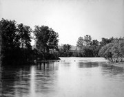
Photograph was taken from the riverbank and shows the steel bridge in Souris, MB. A second wooden bridge is visible behind the steel bridge. The residence of Dr. W.A. Sherrin can be seen to the right of the bridges.
Notes
Dr. Sherrin's residence was identified using the Illustrated Souvenir of Souris, Manitoba (p. 38).
Name Access
Souris, MB
W.A. Sherrin
Souris River
Subject Access
bridges
Storage Location
RG 5 photograph storage drawer 2 (hanging photos)
Images
Show Less

Willow Creek Bridge

http://archives.brandonu.ca/en/permalink/descriptions9916
Part Of
RG 11 Lawrence Stuckey fonds
Description Level
Item
GMD
graphic
Date Range
August 18, 1947
Accession Number
1-2002
Part Of
RG 11 Lawrence Stuckey fonds
Creator
L.A. Stuckey
Description Level
Item
Series Number
3.1
Item Number
1-2002.3.1OB2
Accession Number
1-2002
GMD
graphic
Date Range
August 18, 1947
Physical Description
2 1/2" x 4"
Material Details
Negative
Custodial History
For custodial history see the collection level description of the Lawrence Stuckey collection.
Scope and Content
Willow Creek Bridge
Notes
Old concrete bridge on Valley Road [Provincial Road 457]
Built ca. 1921, replaced in 1970s.
Name Access
Willow Creek Bridge
Subject Access
manmade geographic features
bridges
Brandon Area Bridges
Repro Restriction
The McKee Archives is the copyright holder for the Stuckey materials.
Storage Location
Lawrence Stuckey collection
Images
Show Less

Homemade grain elevator on Chapman Farm, Kirkhams Bridge, northwest of Brandon.

http://archives.brandonu.ca/en/permalink/descriptions10778
Part Of
RG 11 Lawrence Stuckey fonds
Description Level
Item
GMD
graphic
Date Range
July 11, 1981
Accession Number
1-2002
Part Of
RG 11 Lawrence Stuckey fonds
Creator
L.A. Stuckey
Description Level
Item
Series Number
3.3
Item Number
1-2002.3.3.BNW[282]
Accession Number
1-2002
GMD
graphic
Date Range
July 11, 1981
Physical Description
2.25" x 2.25" (b/w)
Material Details
Negative
History / Biographical
Stuckey's notes: Centennial farm. On this date the Chapman family celebrated 100 years continuous farming on this land.
Custodial History
For custodial history see the collection level description of the Lawrence Stuckey collection.
Scope and Content
Image of a homemade grain elevator on Chapman Farm, Kirkhams Bridge, northwest of Brandon.
Notes
[Brandon NW includes communities north of Trans-Canada #1 highway and west of PTH #10.]
Name Access
Brandon, Manitoba
Subject Access
Grain elevators
Repro Restriction
The McKee Archives is the copyright holder of the Stuckey materials.
Storage Location
Lawrence Stuckey collection
Images
Show Less

Second 1st street bridge

http://archives.brandonu.ca/en/permalink/descriptions8714
Part Of
RG 11 Lawrence Stuckey fonds
Description Level
Item
GMD
graphic
Date Range
1971
Accession Number
1-2002
Part Of
RG 11 Lawrence Stuckey fonds
Creator
Lawrence Stuckey
Description Level
Item
Series Number
3.9
Item Number
1-2002.3.9.94
Accession Number
1-2002
GMD
graphic
Date Range
1971
Physical Description
5" x 7" (b/w)
History / Biographical
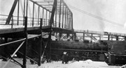
Stuckey's notes: Built 1909, pedestrian sidewalk added 1929. a. Junction Assiniboine Ave. ramp & CPR Yard Office. b. Section over river (north end). c. CPR employees stairway. d. south approach & Empire Brewery. e. distant view from Pacific Ave.
Scope and Content
Photograph is looking north northeast and shows the south approach and the former Empire Brewery building (sign on the building in the photo says Lindenburg B?) at 1st Street and Pacific Avenue.
Notes
Corresponds with negative 1-2002.3.9.BA2(d).
Repro Restriction
The McKee Archives is the copyright holder for the Stuckey materials.
Location Original
1-2002.3.1BA2(d)
Storage Location
RG 5 photograph storage drawer
Related Material
1-2002.3.9.BA2(a) to 1-2002.3.9.BA2(e).
Images
Show Less

20 records – page 3 of 1.