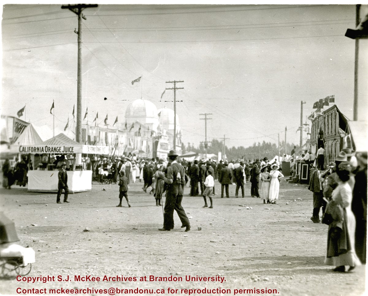
Photograph shows the midway at the 1913 Dominion Fair. Attractions include California Orange Juice stand and Patterson's Animal Trainer Show. The Dominion Exhibition Display Building II can be seen in the background.
Notes
Photograph appears to be a part of a sequence of photographs, see 20-2009.30 to 20-2009.40
In celebration of Brandon's 125th Birthday, the McKee Archives organized the photo exhibit "Wonder City of the Northwest," on display from June 28 until the end of August 2007 in the Curve Gallery, located on the second level of BU's John E. Robbins Library. The photographs in the exhibit marked various passages in the history of Brandon from 1882 to the beginning of the Great War in 1914. A special opening for "Wonder City of the Northwest," sponsored by the President's Office, was held on Thursday, June 28 at 2:00 p.m. in the Curve Gallery.
Custodial History
Contents of the file were created during the process of organizing and curating the Wonder City of the Northwest exhibit.
Scope and Content
File consists of all bids made on the photographic prints in the exhibit, the silent auction form, research gathered for the information boards (including sections of Steen and Boyce's book on Brandon)
Notes
Correspondence and budget records related to the exhibit are held in the annual correspondence and budget files.
Storage Location
RG 6 Brandon University fonds
Series 8: Library Services
8.2 S.J. McKee Archives
Two of the photos (Martin Johns and Freshie Week) are coming away from the backing board.
History / Biographical
The photographs in the exhibit were selected by Christy Henry from the Brandon University photograph collection, the Clark Hall scrapbooks, the Arend Visser collection, the Lois and Gordon Daly fonds and the Frances Percival (nee Fraser) fonds. The photos were selected to compliment slate art pieces created by Barb Flemington that were used in the same exhibit. The goal was to select photos that would reference the relationship between the slate, the buildings and the students and faculty who lived and learned at Brandon College. Henry also tried to choose images that were dynamic enough to hopefully stand on their own in addition to supporting Flemington's work. The exhibit was mounted on the Tommy McLeod Curve Gallery in the John E. Robbins Library from December 1, 2008 to January 12, 2009. A closing reception was held at the Tommy McLeod Curve Gallery on January 9, 2009.
Custodial History
Photographs used in the exhibit are housed in the McKee Archives. The reproductions were made by Brandon Photographics and the mounting was done by Frame Ups.
Scope and Content
Consists of the ten photographic reproductions (mounted on foam board) used for the translate exhibit.
Notes
Description by Christy Henry.
Storage Location
RG 6 Brandon University fonds
Series 8: Library Services
8.2 S.J. McKee Archives
8.2.4 Archival displays
Some calendars, especially the early ones, are fragile.
History / Biographical
See RG 6, series 6 (Senate), sub-series 6.6 (Brandon College/University Calendars) for history/bio information.
Scope and Content
Sub sub series consists of bound archival copies of the Brandon College calendar dating from 1900 to 1985. Box 1 contains calendars from 1900 to 1944. Box 2 contains calendars from 1945 to 1974. Box 3 contains calendars from 1975-85.
Accruals
Further accruals are expected.
Storage Location
RG 6 Brandon University fonds
Series 6: Senate
6.6 Brandon College/University Calendars
Edward Walker was a native of England. In 1895, he left his home in Stockport England and traveled to the village of Millwood, Manitoba where, with three of his five children, he began a new life on the Canadian settlement frontier.
Walker was a professional photographer and his fonds contains a variety of images of Millwood and the surrounding agricultural community, its people, and life. These images were produced from gelatin dry plate negatives, a process introduced around 1880 to replace the wet collodin process in which a photographic solution was applied to a glass plate just prior to exposure. Edward Walker’s pictorial account of life in and around Millwood Manitoba circa 1900 is an important photographic legacy of pioneer life on the upper reaches of the Assiniboine Valley.
The village of Millwood was - and is - located in the Assiniboine River valley close to the Manitoba-Saskatchewan border just a few miles northwest of Binscarth and a similar distance southwest of Russell. It came into existence in 1887 with the construction of the Manitoba and North-Western Railway, a road that ran diagonally through the new West from Prince Albert, North West Territories to Portage la Prairie Manitoba.
Custodial History
These photographic images are drawn from the Edward Walker fonds held at the S.J. McKee Archives. They were used in an exhibit entitled "Millwood on the Assiniboine circa 1900" in 2005. The exhibit was located on The Curve Gallery in the John E. Robbins Library and curated by Tom Mitchell.
Scope and Content
Consists of 22 photographic prints mounted on foam board used by the Archives for the display.
Notes
A selection of thes images are on display in the S. J. McKee Archives. The balance are in storage at RG 6 Brandon University fonds, Series 8: Library Services, 8.2 S.J. McKee Archives.
Storage Location
RG 6 Brandon University fonds
Series 8: Library Services
8.2 S.J. McKee Archives
Images of a Prairie City was a photography display of early Brandon circa 1912. The exhibition presented images of Brandon in the years immediately prior to the Great War when the city had moved beyond a pioneer stage and taken on the features of a modern North American urban centre, boasting parks, exhibitions, paved streets, and the latest trends in architecture and transportation.
Custodial History
These photographic images were drawn from the Alfred Fowler collection held at the S.J. McKee Archives. They were used in an exhibit entitled "Images of a Prairie City" in March 2004. The exhibit was located on The Curve Gallery in the John E. Robbins Library and curated by Christy Henry.
Scope and Content
Consists of 21 photographic prints (in frames) used by the Archives.
Notes
Seven photographs and the information page are on display in Student Services, McKenzie Building, Room 102. Six are on dislay in McKenzie Building, Room 117 and two are on display in McKenzie Building, Room 104. The remainder of the display is in storage at RG 6 Brandon University fonds
Series 8: Library Services 8.2, S.J. McKee Archives. The prints stored in the Archives should be handled with great care.
Storage Location
RG 6 Brandon University fonds
Series 8: Library Services
8.2 S.J. McKee Archives
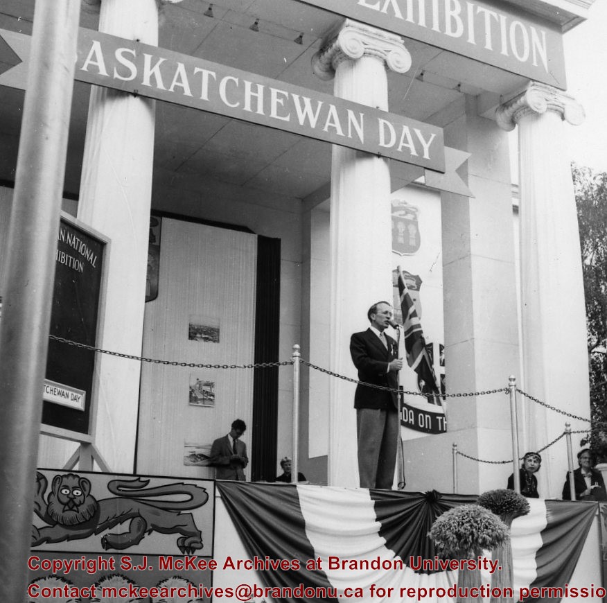
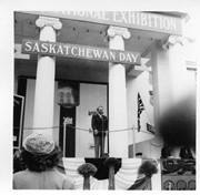
Thomas "Tommy" Clement Douglas (1904-1986) was a Baptist minister and social democratic politician. In 1935, he became a member of parliament representing the Co-operative Commonwealth Federation (CCF). From 1944 to 1961, he served as Saskatchewan's seventh premier whose CCF party introduced the universal health care program. In 1961 Douglas returned to federal politics, where he served as the leader of the New Democratic Party (NDP). He remained in federal politics until 1979.
Scope and Content
Photograph shows Saskatchewan premier Tommy Douglas at a microphone. Behind him are large ionic columns on which a "Saskatchewan Day" wooden banner is mounted. Mounted on the frieze above the columns is another sign that partially reads "National Exhibition."
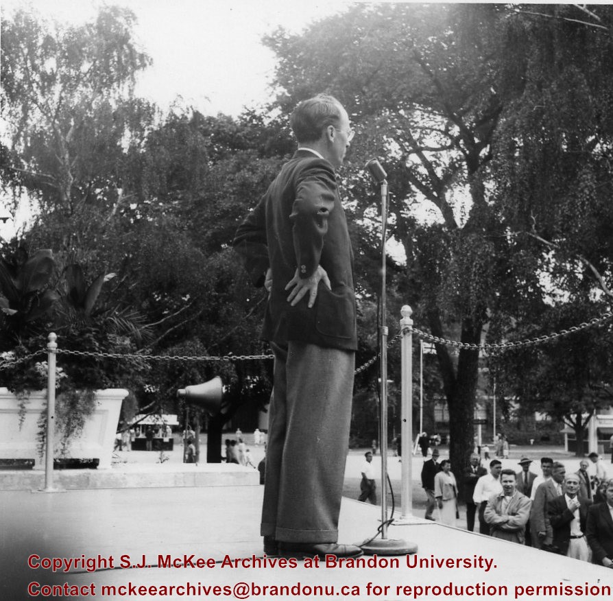
Thomas "Tommy" Clement Douglas (1904-1986) was a Baptist minister and social democratic politician. In 1935, he became a member of parliament representing the Co-operative Commonwealth Federation (CCF). From 1944 to 1961, he served as Saskatchewan's seventh premier whose CCF party introduced the universal health care program. In 1961 Douglas returned to federal politics, where he served as the leader of the New Democratic Party (NDP). He remained in federal politics until 1979.
Scope and Content
Photograph shows a close-up of Saskatchewan premier Tommy Douglas at a microphone at the Canadian National Exhibition.
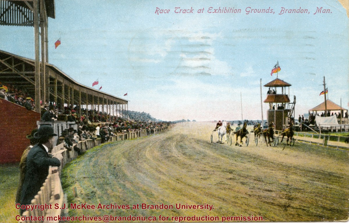
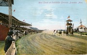
Postcard shows the grandstand and race track located at the Exhibition Grounds (now the site of the Keystone Centre/Westman Communications Place) in the south end of Brandon, Manitoba. The bleachers are filled with people and spectators also line the fence alongside the track. Five harness racers are making their way along the track. An observation tower and possible gazebo for dignitaries is located inside the track.
Notes
The back of the postcard is address to Mrs. Sharpe of Banff, Alberta. A green King George One Cent stamp has been postmarked Sault Ste. Maire, Ont., July 6, 1910. The message reads: Lake Superior, My dear. How are you? Glad you are charmed with B. don't get too fat. Tell Mrs. Coates my state room companion is Miss Rutherford of B. Coll: she got on at Port Arthur. Having a lovely trip. It was hard parting at B. .......Address 14 Deer Park, Toronto. Postcard manufactured by Stedman Bros. Ltd., Brantford, Canada. S.B. 2376. Made in Germany.
The Medicine Hat Exhibition and Stampede Parade Day was held on Thursday, July 19, 1962, at 9:30 a.m. The local newspaper reported that approximately 24,000 people were in attendance to see parade marshall Rod Ashburner leading 175 entries consisting of 90 floats, 75 horses, and 10 bands. There were 19 parade categories eligible for $12,000 in prize money and included: junior and senior cowboys and cowgirls; fancy and Shetland ponies; sulky class open; comic, commercial, industrial and organizational floats; decorated cars; special ranch class; 4-H Clubs; and a non-competitive class.
The parade route started at Second St. and Allowance Ave., from Second St. to Ash Ave., north on Ash to First St. SE., from First St. S.E. to Fourth Ave., south to Second St. to South Railway St., south on South Railway St. to Third St., with a finish at McLeod Trail. A route map was published in the Medicine Hat News the day before the parade.
Aerial photographs of the parade were taken by Medicine Hat News photographer Howard Heid (1930-2005) from the private helicopter of John Bourn. Bourn was a pilot from Woodville, Wisconsin, who chartered his four-seater helicopter for sight-seers at exhibitions and stampedes across the county.
(Sources: Pat Currie, "Let 'Er Go!," Medicine Hat News, 19 July 1962,1; Harald Gunderson, "'Eye in the Sky' Best Parade View," Medicine Hat News, 19 July 1962,1; "Parade Starts at 9:30 Sharp," 18 July 1962)
Scope and Content
Photograph shows an aerial view of the Medicine Hat Exhibition and Stampede Parade route, with a focus on Second Street SE. A residential area showing homes with extensive backyard gardens can be seen. The South Saskatchewan River can be see on the right of the photograph.
Notes
This photograph shows the neighbourhood before rezoning and commercial development.
The Medicine Hat Exhibition and Stampede Parade Day was held on Thursday, July 19, 1962, at 9:30 a.m. The local newspaper reported that approximately 24,000 people were in attendance to see parade marshall Rod Ashburner leading 175 entries consisting of 90 floats, 75 horses, and 10 bands. There were 19 parade categories eligible for $12,000 in prize money and included: junior and senior cowboys and cowgirls; fancy and Shetland ponies; sulky class open; comic, commercial, industrial and organizational floats; decorated cars; special ranch class; 4-H Clubs; and a non-competitive class.
The parade route started at Second St. and Allowance Ave., from Second St. to Ash Ave., north on Ash to First St. SE., from First St. S.E. to Fourth Ave., south to Second St. to South Railway St., south on South Railway St. to Third St., with a finish at McLeod Trail. A route map was published in the Medicine Hat News the day before the parade.
Aerial photographs of the parade were taken by Medicine Hat News photographer Howard Heid (1930-2005) from the private helicopter of John Bourn. Bourn was a pilot from Woodville, Wisconsin, who chartered his four-seater helicopter for sight-seers at exhibitions and stampedes across the county.
(Sources: Pat Currie, "Let 'Er Go!," Medicine Hat News, 19 July 1962,1; Harald Gunderson, "'Eye in the Sky' Best Parade View," Medicine Hat News, 19 July 1962,1; "Parade Starts at 9:30 Sharp," 18 July 1962)
Scope and Content
Photograph shows an aerial view of the Medicine Hat Exhibition and Stampede Parade route, with a focus on Second Street SE. Visible store signs include: China Wonderland, Grey Cup Cafe, Lane Bros. & Gibson Ltd., Joy's, Marshall's, Monarch, Gardener's Used Cars, Provincial Treasury Branch, Furvey's Furniture and Appliances, J.J. Moore & Son, Club Cafe, Black Hardware Ltd., Regency Billards, and Sair's Shoe Hospital.
The Medicine Hat Exhibition and Stampede Parade Day was held on Thursday, July 19, 1962, at 9:30 a.m. The local newspaper reported that approximately 24,000 people were in attendance to see parade marshall Rod Ashburner leading 175 entries consisting of 90 floats, 75 horses, and 10 bands. There were 19 parade categories eligible for $12,000 in prize money and included: junior and senior cowboys and cowgirls; fancy and Shetland ponies; sulky class open; comic, commercial, industrial and organizational floats; decorated cars; special ranch class; 4-H Clubs; and a non-competitive class.
The parade route started at Second St. and Allowance Ave., from Second St. to Ash Ave., north on Ash to First St. SE., from First St. S.E. to Fourth Ave., south to Second St. to South Railway St., south on South Railway St. to Third St., with a finish at McLeod Trail. A route map was published in the Medicine Hat News the day before the parade.
Aerial photographs of the parade were taken by Medicine Hat News photographer Howard Heid (1930-2005) from the private helicopter of John Bourn. Bourn was a pilot from Woodville, Wisconsin, who chartered his four-seater helicopter for sight-seers at exhibitions and stampedes across the county.
(Sources: Pat Currie, "Let 'Er Go!," Medicine Hat News, 19 July 1962,1; Harald Gunderson, "'Eye in the Sky' Best Parade View," Medicine Hat News, 19 July 1962,1; "Parade Starts at 9:30 Sharp," 18 July 1962)
Scope and Content
Photograph shows an aerial view of the Medicine Hat Exhibition and Stampede Parade route, with a focus on the First Street SE and North Railway Street merge.
Notes
This photograph appeared on the front page of The Medicine Hat News (19 July 1962).
The Medicine Hat Exhibition and Stampede Parade Day was held on Thursday, July 19, 1962, at 9:30 a.m. The local newspaper reported that approximately 24,000 people were in attendance to see parade marshall Rod Ashburner leading 175 entries consisting of 90 floats, 75 horses, and 10 bands. There were 19 parade categories eligible for $12,000 in prize money and included: junior and senior cowboys and cowgirls; fancy and Shetland ponies; sulky class open; comic, commercial, industrial and organizational floats; decorated cars; special ranch class; 4-H Clubs; and a non-competitive class.
The parade route started at Second St. and Allowance Ave., from Second St. to Ash Ave., north on Ash to First St. SE., from First St. S.E. to Fourth Ave., south to Second St. to South Railway St., south on South Railway St. to Third St., with a finish at McLeod Trail. A route map was published in the Medicine Hat News the day before the parade.
Aerial photographs of the parade were taken by Medicine Hat News photographer Howard Heid (1930-2005) from the private helicopter of John Bourn. Bourn was a pilot from Woodville, Wisconsin, who chartered his four-seater helicopter for sight-seers at exhibitions and stampedes across the county.
(Sources: Pat Currie, "Let 'Er Go!," Medicine Hat News, 19 July 1962,1; Harald Gunderson, "'Eye in the Sky' Best Parade View," Medicine Hat News, 19 July 1962,1; "Parade Starts at 9:30 Sharp," 18 July 1962)
Scope and Content
Photograph shows an aerial view of the Medicine Hat Exhibition and Stampede Parade route with a focus on the First Street SE. A number of gas stations and garages are visible along this route and include Texaco, Shell, Ford, and B/A. The Fraternal Order of Eagles lodge is also visible.
Notes
This photograph appeared on the front page of The Medicine Hat News (19 July 1962).
The Medicine Hat Exhibition and Stampede Parade Day was held on Thursday, July 19, 1962, at 9:30 a.m. The local newspaper reported that approximately 24,000 people were in attendance to see parade marshall Rod Ashburner leading 175 entries consisting of 90 floats, 75 horses, and 10 bands. There were 19 parade categories eligible for $12,000 in prize money and included: junior and senior cowboys and cowgirls; fancy and Shetland ponies; sulky class open; comic, commercial, industrial and organizational floats; decorated cars; special ranch class; 4-H Clubs; and a non-competitive class.
The parade route started at Second St. and Allowance Ave., from Second St. to Ash Ave., north on Ash to First St. SE., from First St. S.E. to Fourth Ave., south to Second St. to South Railway St., south on South Railway St. to Third St., with a finish at McLeod Trail. A route map was published in the Medicine Hat News the day before the parade.
Aerial photographs of the parade were taken by Medicine Hat News photographer Howard Heid (1930-2005) from the private helicopter of John Bourn. Bourn was a pilot from Woodville, Wisconsin, who chartered his four-seater helicopter for sight-seers at exhibitions and stampedes across the county.
(Sources: Pat Currie, "Let 'Er Go!," Medicine Hat News, 19 July 1962,1; Harald Gunderson, "'Eye in the Sky' Best Parade View," Medicine Hat News, 19 July 1962,1; "Parade Starts at 9:30 Sharp," 18 July 1962)
Scope and Content
Photograph shows an aerial view of the Medicine Hat Exhibition and Stampede Parade route with a focus on the First Street SE and Ash Street. A residential area showing homes with extensive backyard gardens can be seen.
Notes
This photograph shows the neighbourhood before rezoning and commercial development.
The Medicine Hat Exhibition and Stampede Parade Day was held on Thursday, July 19, 1962, at 9:30 a.m. The local newspaper reported that approximately 24,000 people were in attendance to see parade marshall Rod Ashburner leading 175 entries consisting of 90 floats, 75 horses, and 10 bands. There were 19 parade categories eligible for $12,000 in prize money and included: junior and senior cowboys and cowgirls; fancy and Shetland ponies; sulky class open; comic, commercial, industrial and organizational floats; decorated cars; special ranch class; 4-H Clubs; and a non-competitive class.
The parade route started at Second St. and Allowance Ave., from Second St. to Ash Ave., north on Ash to First St. SE., from First St. S.E. to Fourth Ave., south to Second St. to South Railway St., south on South Railway St. to Third St., with a finish at McLeod Trail. A route map was published in the Medicine Hat News the day before the parade.
Aerial photographs of the parade were taken by Medicine Hat News photographer Howard Heid (1930-2005) from the private helicopter of John Bourn. Bourn was a pilot from Woodville, Wisconsin, who chartered his four-seater helicopter for sight-seers at exhibitions and stampedes across the county.
(Sources: Pat Currie, "Let 'Er Go!," Medicine Hat News, 19 July 1962,1; Harald Gunderson, "'Eye in the Sky' Best Parade View," Medicine Hat News, 19 July 1962,1; "Parade Starts at 9:30 Sharp," 18 July 1962)
Scope and Content
Photograph shows an aerial view of the Medicine Hat Exhibition and Stampede Parade route with a focus on the First Street SE and and the South Railway Street merge. A number of gas stations and garages are visible along this route and include Texaco, Shell, Ford, and B/A. The Fraternal Order of Eagles lodge is also visible.
Notes
This photograph shows the neighbourhood before rezoning and commercial development.
The Medicine Hat Exhibition and Stampede Parade Day was held on Thursday, July 19, 1962, at 9:30 a.m. The local newspaper reported that approximately 24,000 people were in attendance to see parade marshall Rod Ashburner leading 175 entries consisting of 90 floats, 75 horses, and 10 bands. There were 19 parade categories eligible for $12,000 in prize money and included: junior and senior cowboys and cowgirls; fancy and Shetland ponies; sulky class open; comic, commercial, industrial and organizational floats; decorated cars; special ranch class; 4-H Clubs; and a non-competitive class.
The parade route started at Second St. and Allowance Ave., from Second St. to Ash Ave., north on Ash to First St. SE., from First St. S.E. to Fourth Ave., south to Second St. to South Railway St., south on South Railway St. to Third St., with a finish at McLeod Trail. A route map was published in the Medicine Hat News the day before the parade.
Aerial photographs of the parade were taken by Medicine Hat News photographer Howard Heid (1930-2005) from the private helicopter of John Bourn. Bourn was a pilot from Woodville, Wisconsin, who chartered his four-seater helicopter for sight-seers at exhibitions and stampedes across the county.
(Sources: Pat Currie, "Let 'Er Go!," Medicine Hat News, 19 July 1962,1; Harald Gunderson, "'Eye in the Sky' Best Parade View," Medicine Hat News, 19 July 1962,1; "Parade Starts at 9:30 Sharp," 18 July 1962)
Scope and Content
Photograph shows an aerial view of the Medicine Hat Exhibition and Stampede Parade route with a focus on the First Street SE and Sixth Avenue intersection. A number of gas stations and garages are visible along this route and include Texaco, Shell, Ford, and B/A. A number of observers can be seen sitting on rooftops.
Notes
This photograph shows the neighbourhood before rezoning and commercial development.
The Medicine Hat Exhibition and Stampede Parade Day was held on Thursday, July 19, 1962, at 9:30 a.m. The local newspaper reported that approximately 24,000 people were in attendance to see parade marshall Rod Ashburner leading 175 entries consisting of 90 floats, 75 horses, and 10 bands. There were 19 parade categories eligible for $12,000 in prize money and included: junior and senior cowboys and cowgirls; fancy and Shetland ponies; sulky class open; comic, commercial, industrial and organizational floats; decorated cars; special ranch class; 4-H Clubs; and a non-competitive class.
The parade route started at Second St. and Allowance Ave., from Second St. to Ash Ave., north on Ash to First St. SE., from First St. S.E. to Fourth Ave., south to Second St. to South Railway St., south on South Railway St. to Third St., with a finish at McLeod Trail. A route map was published in the Medicine Hat News the day before the parade.
Aerial photographs of the parade were taken by Medicine Hat News photographer Howard Heid (1930-2005) from the private helicopter of John Bourn. Bourn was a pilot from Woodville, Wisconsin, who chartered his four-seater helicopter for sight-seers at exhibitions and stampedes across the county.
(Sources: Pat Currie, "Let 'Er Go!," Medicine Hat News, 19 July 1962,1; Harald Gunderson, "'Eye in the Sky' Best Parade View," Medicine Hat News, 19 July 1962,1; "Parade Starts at 9:30 Sharp," 18 July 1962)
Scope and Content
Photograph shows an aerial view of the Medicine Hat Exhibition and Stampede Parade route, with a focus on Second Street SE. Visible store signs include: Gardener's Used Cars, Provincial Treasury Branch, Furvey's Furniture and Appliances, J.J. Moore & Son Furniture, Alberta Credit Jewellers, James Richardson & Sons, Medicine Hat Gas Power Water City Owned Utilities.
Notes
This photograph shows the neighbourhood before rezoning and commercial development.


