Field journals have been scanned in multi-page PDF files. Artifact catalogues are PDF files in spreadsheet format. Photographs are in jpeg format
History / Biographical
Over a period from 1997 to 2000 over 40 test pits were surveyed and five test units put in. Crew members included: Bev Nicholson, Scott Hamilton, Matt Boyd, Tomasin Playford, Lori Mokelki, T.J Hall, Rea Postoloski, Andy Belcourt, Jace Moon, Michelle Drysdale as well as others.
Field journals have been scanned in multi-page PDF files. Artifact catalogues are PDF files in spreadsheet format. Photographs are in jpeg format.
History / Biographical
After the flooding of the Souris River in 2004 receded, Tomasin Playford and her crew of Andrea Richards, Sarah Graham and Shane Kolesar returned to the Atkinson site and commenced cleaning up the earlier excavation of Atkinson.
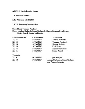
An area east of the Atkinson excavations was also opened for testing in 2004. This area was designated as Atkinson II. In some of the field notes it is referred to as Atkinson East. A test block was opened and fenced off from the cattle with snow fence. A 4m2 block was surveyed in (units 13 - 16) and two partial units that were truncated by the riverbank (units 11 &12) were also placed to the south of the 4m2 block.
Three of the students who had completed the recent field school were hired as crew. Jessica McKenzie, Evie Fevez and Emily Ansell joined the crew at the Atkinson II site.
Recoveries from XU 13 - 16:
Large bison bone was recovered from units 11 and 12 and a metal tobacco box seal was recovered from unit 12. More small pieces of metal found in levels 2 and three together with small bone fragments. A bone fragment with butchering marks from a metal tool was recovered from level 6 and pottery was found in level 9. A few lithic flakes were found in level 13 and in a trench at the bottom of unit 13 above a calcite cemented layer. Recoveries from these tests were sparse and diminished as the excavation series became more distant from the river. It is likely that the remains that were recovered represent the northern edge of these occupations.
The upper occupation at Atkinson II appears to be an early historic occupation with a sparse scatter of bone and a few pieces of metal. The lower layers, below level 7 are likely precontact. Units 9 and 10 were dug as test pits and produced very little in the way of cultural materials.
Scope and Content
Sub-sub-sub series contains: Summary information of field methology, number and co-ordinates of excavations, personnel and their staff position; Field journals are daily records of recoveries, features and activities at the site; Site records include excavation level and unit summaries, feature sheets, profiles; sample records and maps; Artifact catalogues are lists and identifications of all artifacts recovered; Photographs are of excavation units, features, the landscape and personnel.
This is an artificially created series containing records retained by Manitoba Pool Elevators of official commissions, committee and inquiries that dealt directly with the organization and it's interests. Subjects include commission investigation as well and committee and inquiries into government policy and bills.
See also fonds level description of RG 4 for history/bio of MPE
Scope and Content
.This series has been divided into seven sub-series, including: (1) Royal Commission on Co-operatives, (2) Royal Commission on Manitoba Pool Elevators, (3) Transportation Commissions and Inquiries, (4) Box Car Inquiry, (5) Grain Commissions and Inquiries, (6) Agricultural Commissions and Policy, (7) Miscellaneous Committes, Commissions and Inquiries
Field journals have been scanned in multi-page PDF files. Artifact catalogues are PDF files in spreadsheet format. Photographs are in jpeg format
History / Biographical
Based on the results of the testing in 2002 and the radiocarbon date of 6,400 years before present, further excavation was warranted at the Atkinson I site. In 2003 Field Chief Holly Alston and crew Shayne Kolesar and Andrea Richards opened a 42m test excavation (units 1 - 4) that included the hearth area.
The unit co-ordinates and excavator are listed on the attached pdf file.
Field journals have been scanned in multi-page PDF files. Artifact catalogues are PDF files in spreadsheet format. Photographs are in jpeg format
History / Biographical
Based on the results of the 2003 excavation, and the radiocarbon date of 6,200 years before present, further excavation was warranted at the Atkinson I site.
In 2004 four units (5, 6, 7, & 8) were surveyed in adjacent to the 2003 units. The unit co-ordinates and excavator are listed on the attached pdf file.
Field journals have been scanned in multi-page PDF files. Artifact catalogues are PDF files in spreadsheet format. Photographs are in jpeg format
History / Biographical
An area east of the Atkinson excavations was also opened for testing in 2004. This area was designated as Atkinson II and a test block was opened and fenced off from the cattle with snow fence. A 4m2 block was surveyed in (units 13 - 16) and two partial units that were truncated by the riverbank (units 11 &12) were also placed to the south of the 4m2 block. Test units 9 and 10 were also excavated.
Introduction
Information on archaeological materials in this locale first came to the attention of Dr. Nicholson through Doug Jackson, a local artifact collector from Souris. Doug had observed archaeological materials that included bone, ceramics and lithic material that had been exposed by municipal road building activity, northwest of Lauder Manitoba
Environment
The Makotchi-Ded Dontipi locale is located among stabilized sand dunes in the Lauder Sandhills in Southwestern Manitoba, northwest of the village of Lauder. The area is a mosaic of medium grass prairie and copses of aspen poplar and aspen-oak, together with intermittent sedge grass marshes and small ponds. These wetlands are bordered with balsam poplar, water birch, willows and red osier dogwood.
The well-drained upland forest also contains saskatoon, chokecherry, wild current, hazelnut bushes and occasional wild plums. Lowland areas have nannyberries and high-bush cranberry. Wild strawberries grow in lightly shaded areas along trail margins and in open patches in aspen forest.
History of Excavations
The Makotchi-Ded Dontipi locale is a virtual "island" of forest and marshlands in a vast expanse of mixed grass prairie. This archaeologically and environmentally rich area was given the Dakota name Makotchi-Ded Dontipi, meaning "the place where we live".
Summation
Prior to European settlement, the area was a rich environment for hunter-gatherer people. Archaeological investigations from 1992 to 2002 have revealed numerous sites within the locale. Some of these sites have been extensively excavated while others have been identified or tested.
Seven sites that have been identified in this locale range in age from the historic through protohistoric periods and extend into the middle precontact period. The major sites are the initial Middle Missouri Duthie site, the late precontact Jackson, Bradshaw sites and the protohistoric Twin Fawns, Schuddemat and Hollow B sites. The multi-component Vera site includes historic Métis, late precontact Vickers Focus, and middle precontact Besant, Pelican Lake, McKean Complex and Oxbow occupations. Over 230 units were excavated as well as numerous test pits and several extensive surveys.
Scope and Content
Scope and Content
The Series has been divided into seven sub-series, including (1) Duthie site (2) Jackson site (3) Twin Fawns site (4) Vera site (5) Schuddemat site (6) Bradshaw site (7) Hollow B site.
ARCH 2: North Lauder Locale
The North Lauder locale has a long archaeological and geological history that is important for understanding the forces that shaped the region. Archaeological research in the locale shows that the area has been occupied by humans for at least the past 6,500 years. Environmental forces provided an area of diverse resources that attracted early peoples.
Environment of the Lauder Sandhills
The North Lauder locale is part of the greater Lauder Sandhills area. The glaciers that covered this region began to recede approximately 11,000 years ago leaving a large lake known as glacial Lake Hind. The Souris River, the Lauder Sandhills and the Oak Lake Aquifer are remnants of the environmental and geological forces that shaped the region.
The Lauder Sandhills region is characterized by a landscape of sand sheets and stabilized sand dunes interspersed with a variety of wetlands. This complex topographic and hydrological situation favoured the development of an island mosaic of mixed forest, wetland and meadow, surrounded by mixed grass prairie. The result was a large, isolated ecotone which provided a rich variety of subsistence resources for hunter-gatherers.
Research in the Lauder Sandhills
Archaeologists from Brandon University have been conducting research in the Lauder Sandhills since 1991. Research in the North Lauder locale has focused on the Atkinson site, a 6,500 year old hunter-gatherer site and Flintstone Hill.
The Atkinson site
The Atkinson site is one of the oldest excavated sites in Manitoba and has been Radiocarbon dated to 6,500 years before present. The Atkinson site is located on the bank of the Souris River and was discovered when a hearth (fire pit) was seen eroding out of the bank. Based on the date of the site and the kind of lithics (stone tools) present it is considered a Gowen occupation. The Atkinson site is evidence that bison hunters were active on the northern plains at a very early date. Similar sites have also been found on the High Plains in the U.S. and are referred to as the Mummy Cave Complex.
The Atkinson Site is of great importance as it is the first undisturbed site of this type to be excavated in Manitoba and extends the range of these sites south and east from the type-sites in central Saskatchewan.
Flintstone Hill
The geomorphology of the glacial Lake Hind Basin over the past 11,000 years is known primarily through the study of a cut bank along the Souris River. Flint Stone Hill contains the most complete stratigraphic record for the post-glacial period on the northern plains. The site has been extensively studied by geoarchaeologists, geologists and paleoenvironmentalists over many years and their findings have contributed to our understanding of the region.
The North Lauder locale Borden designations of Atkinson site DiMe-27 and Flintstone Hill site DiMe-26.
Borden System
Archaeological sites in Canada are identified by the Borden system, which is a uniform site designation system. The country is divided into grids based on latitude and longitude in blocks of 10 x 20 minutes. The first 4 letters indicate the block and the following numbers indicate the actual site. For example the area of the Lauder Sandhills in southwestern Manitoba is identified by the letters DM and the North Lauder locale within that area is DiMe. The Atkinson site is DiMe-27 and the Flintstone Hill site DiMe-26. As new sites are discovered they will be numbered sequentially.
Scope and Content
The Series has been divided into two sub-series, including (1) Atkinson site DiMe-27 and Flintstone Hill site DiMe-26.