Skip header and navigation

Revise Search

20 records – page 1 of 1.

North and South America

http://archives.brandonu.ca/en/permalink/specialcollections952
Part Of
MG 2 2.15 George E Thorman Collection
Description Level
Item
Date Range
1948, c1943
Part Of
MG 2 2.15 George E Thorman Collection
Collection
George E Thorman School Textbook Collection
Creator
Stamp, L. Dudley (Laurence Dudley), 1898-1966
Kimble, George Herbert Tinley, 1908
Description Level
Item
Item Number
Archives 11-999-11-322
Item Number Range
Archives 11-999-11-322
Responsibility
edited by L. Dudley Stamp and George H.T. Kimble
Start Date
1948, c1943
Date Range
1948, c1943
Publication
Toronto : Longmans, Green
Publisher Series
Geography for to-day
Physical Description
viii, 129 p. : ill., maps ; 19 cm
Notes
Includes bibliographical references and indexes
Subject Access
North America Description and travel
South America Description and travel
Storage Location
Box 11 - Geography
Storage Range
Box 11 - Geography
Show Less

Timothy Beans - north side

http://archives.brandonu.ca/en/permalink/descriptions13925
Part Of
Fred McGuinness collection
Description Level
Item
GMD
graphic
Date Range
c.1996 - 2002
Accession Number
20-2009
Part Of
Fred McGuinness collection
Description Level
Item
Series Number
McG 9
Item Number
20-2009.235
Accession Number
20-2009
GMD
graphic
Date Range
c.1996 - 2002
Physical Description
1.5" x 1" (colour)
Material Details
negative
History / Biographical
Timothy Beans Cappaccino Bar was located at 139 - 10th Street, Brandon, Manitoba.
Scope and Content
Photograph shows north side of the Timothy Beans cybercafe on 10th Street, Brandon
Notes
Negative #25
Name Access
Timothy beans
Subject Access
internet cafes
cafes
Storage Location
RG 5 photograph storage drawer 2 (hanging photos)
Arrangement
From 20-2009 File #19
Images
Show Less

CNR Station at Brandon North

http://archives.brandonu.ca/en/permalink/descriptions9966
Part Of
RG 11 Lawrence Stuckey fonds
Description Level
Item
GMD
graphic
Date Range
[ca. 1940]
Accession Number
1-2002
Part Of
RG 11 Lawrence Stuckey fonds
Description Level
Item
Series Number
3.1
Item Number
1-2002.3.1PC5
Accession Number
1-2002
GMD
graphic
Date Range
[ca. 1940]
Physical Description
3 1/2" x 5"
Material Details
Negative
History / Biographical
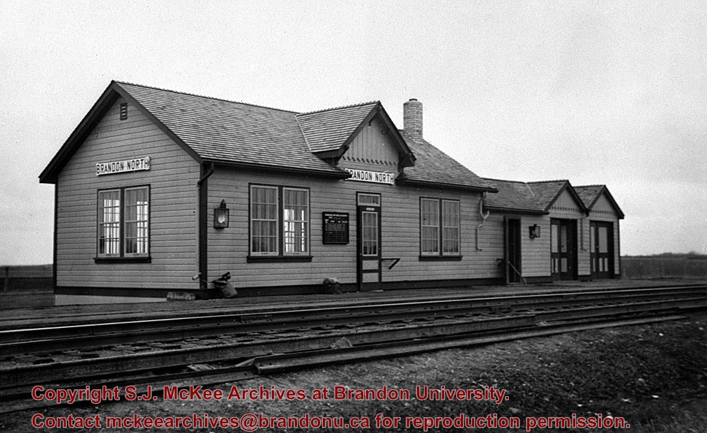
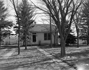
[This station, located 13 km north of Brandon on the east side of PTH 10, was] built in the early 1930s to replace Knox as the CNR’s mainline station for Brandon. All passenger trains stopped and buses operated between the CNR’s Brandon station and Brandon North to meet all trains. It was enlarged as shown here in late 1930s, and at peak operation in the 1940s & 1950s saw six daily passenger trains 1 - 2 & 3 - 4 “Continental Limited” and 11 - 12 locals. VIA trains 3 and 4 "Supercontinental" ceased operation Nov. 15, 1981 leaving no passenger service on the former Grand Trunk Pacific mainline of CNR [at that time]. This station was demolished in the fall of 1982.
Custodial History
For custodial history see the collection level description of the Lawrence Stuckey collection.
Scope and Content
CNR Station at Brandon North
Name Access
CNR Station
Subject Access
railroads
railways
railway stations
Canadian National Railways in Brandon - Early
Repro Restriction
The McKee Archives is the copyright holder for the Stuckey materials.
Storage Location
Lawrence Stuckey collection
Images
Show Less

The Bank of British North America

http://archives.brandonu.ca/en/permalink/descriptions10113
Part Of
RG 12 Brandon and Area Photograph Collection
Description Level
Item
GMD
graphic
Part Of
RG 12 Brandon and Area Photograph Collection
Description Level
Item
Series Number
1
Item Number
BAPC 1.7
GMD
graphic
Physical Description
2.5" x 3" (b/w)
Material Details
Negative
Custodial History
Donated by John Everitt on September 24, 2007.
Scope and Content
Photographic negative of The Bank of British North America in Belmont, MB.
Name Access
Belmont
Bank of British North America
Subject Access
banks
Storage Location
BAPC photograph drawer
Images
Show Less

Old barn, north of Douglas

http://archives.brandonu.ca/en/permalink/descriptions10915
Part Of
RG 11 Lawrence Stuckey fonds
Description Level
Item
GMD
graphic
Date Range
April 3, 1977
Accession Number
1-2002
Part Of
RG 11 Lawrence Stuckey fonds
Creator
L.A. Stuckey
Description Level
Item
Series Number
3.3
Item Number
1-2002.3.3.BNE[323]
Accession Number
1-2002
GMD
graphic
Date Range
April 3, 1977
Physical Description
2.25" x 2.25" (b/w)
Material Details
Negative
Custodial History
For custodial history see the collection level description of the Lawrence Stuckey collection.
Scope and Content
Image of old barn, north of Douglas.
Notes
[Brandon NE includes communities north of Trans-Canada #1 highway and east of PTH #10.]
Name Access
Douglas, Manitoba
Subject Access
barns
Repro Restriction
The McKee Archives is the copyright holder of the Stuckey materials.
Storage Location
Lawrence Stuckey collection
Images
Show Less

A North American common market

http://archives.brandonu.ca/en/permalink/specialcollections169
Part Of
RG 4 Manitoba Pool Elevator fonds
Description Level
Item
Date Range
c1969
Part Of
RG 4 Manitoba Pool Elevator fonds
Collection
Manitoba Pool Elevator Library Collection
Creator
Iowa State University. Center for Agricultural and Economic Development
University of Manitoba. Faculty of Agriculture and Home Economics
Description Level
Item
Item Number
Archives 14-4-29
Item Number Range
Archives 14-4-29
Start Date
c1969
Date Range
c1969
Publication
Ames : Iowa State University Press
Physical Description
viii, 442 p. : ill., maps. ; 23 cm
Notes
Papers of a conference sponsored by the University of Manitoba Faculty of Agriculture and Home Economics and the Iowa State University Center for Agricultural and Economic Development
Includes bibliographies
Subject Access
Agriculture and state North America
Agriculture Economic aspects North America
Food supply
Storage Location
Box 4-Historical I
Storage Range
Box 4-Historical I
Show Less

Robbins Library, North Stacks

http://archives.brandonu.ca/en/permalink/descriptions51
Part Of
Brandon University Photograph Collection
Description Level
Item
Date Range
c. 1994
Part Of
Brandon University Photograph Collection
Description Level
Item
Series Number
1
File Number
1.1.37
Item Number
1.1.37
Date Range
c. 1994
Physical Description
colour, 4" x 6"
Scope and Content
Robbins Library – North Stacks. Shows shelves of books
Subject Access
Robbins Library; North Stacks
Show Less

Old log barn on road north to Mountain Road, 1 mile north Polonia Corner

http://archives.brandonu.ca/en/permalink/descriptions10859
Part Of
RG 11 Lawrence Stuckey fonds
Description Level
Item
GMD
graphic
Date Range
October 18,1979
Accession Number
1-2002
Part Of
RG 11 Lawrence Stuckey fonds
Creator
L.A. Stuckey
Description Level
Item
Series Number
3.3
Item Number
1-2002.3.3.BNE[307a]
Accession Number
1-2002
GMD
graphic
Date Range
October 18,1979
Physical Description
2.25" x 2.25" (b/w)
Material Details
Negative
Custodial History
For custodial history see the collection level description of the Lawrence Stuckey collection.
Scope and Content
Image of old log barn on road north to Mountain Road, 1 mile north Polonia Corner.
Notes
[Brandon NE includes communities north of Trans-Canada #1 highway and east of PTH #10.]
Name Access
Mountain Road, Manitoba
Subject Access
barns
Repro Restriction
The McKee Archives is the copyright holder of the Stuckey materials.
Storage Location
Lawrence Stuckey collection
Arrangement
[Mr. Stuckey put two negatives in same envelope. We have separated them and numbered them (307a) and (307b)].
Images
Show Less

ARCH 2: North Lauder locale

http://archives.brandonu.ca/en/permalink/descriptions12079
Part Of
RG 7 Beverley Nicholson fonds
Description Level
Series
GMD
multiple media
Date Range
1997 to present
Accession Number
1-2010
Part Of
RG 7 Beverley Nicholson fonds
Description Level
Series
Series Number
2
Accession Number
1-2010
GMD
multiple media
Date Range
1997 to present
History / Biographical
ARCH 2: North Lauder Locale The North Lauder locale has a long archaeological and geological history that is important for understanding the forces that shaped the region. Archaeological research in the locale shows that the area has been occupied by humans for at least the past 6,500 years. Environmental forces provided an area of diverse resources that attracted early peoples. Environment of the Lauder Sandhills The North Lauder locale is part of the greater Lauder Sandhills area. The glaciers that covered this region began to recede approximately 11,000 years ago leaving a large lake known as glacial Lake Hind. The Souris River, the Lauder Sandhills and the Oak Lake Aquifer are remnants of the environmental and geological forces that shaped the region. The Lauder Sandhills region is characterized by a landscape of sand sheets and stabilized sand dunes interspersed with a variety of wetlands. This complex topographic and hydrological situation favoured the development of an island mosaic of mixed forest, wetland and meadow, surrounded by mixed grass prairie. The result was a large, isolated ecotone which provided a rich variety of subsistence resources for hunter-gatherers. Research in the Lauder Sandhills Archaeologists from Brandon University have been conducting research in the Lauder Sandhills since 1991. Research in the North Lauder locale has focused on the Atkinson site, a 6,500 year old hunter-gatherer site and Flintstone Hill. The Atkinson site The Atkinson site is one of the oldest excavated sites in Manitoba and has been Radiocarbon dated to 6,500 years before present. The Atkinson site is located on the bank of the Souris River and was discovered when a hearth (fire pit) was seen eroding out of the bank. Based on the date of the site and the kind of lithics (stone tools) present it is considered a Gowen occupation. The Atkinson site is evidence that bison hunters were active on the northern plains at a very early date. Similar sites have also been found on the High Plains in the U.S. and are referred to as the Mummy Cave Complex. The Atkinson Site is of great importance as it is the first undisturbed site of this type to be excavated in Manitoba and extends the range of these sites south and east from the type-sites in central Saskatchewan. Flintstone Hill The geomorphology of the glacial Lake Hind Basin over the past 11,000 years is known primarily through the study of a cut bank along the Souris River. Flint Stone Hill contains the most complete stratigraphic record for the post-glacial period on the northern plains. The site has been extensively studied by geoarchaeologists, geologists and paleoenvironmentalists over many years and their findings have contributed to our understanding of the region. The North Lauder locale Borden designations of Atkinson site DiMe-27 and Flintstone Hill site DiMe-26. Borden System Archaeological sites in Canada are identified by the Borden system, which is a uniform site designation system. The country is divided into grids based on latitude and longitude in blocks of 10 x 20 minutes. The first 4 letters indicate the block and the following numbers indicate the actual site. For example the area of the Lauder Sandhills in southwestern Manitoba is identified by the letters DM and the North Lauder locale within that area is DiMe. The Atkinson site is DiMe-27 and the Flintstone Hill site DiMe-26. As new sites are discovered they will be numbered sequentially.
Scope and Content
The Series has been divided into two sub-series, including (1) Atkinson site DiMe-27 and Flintstone Hill site DiMe-26.
Name Access
North Lauder locale
Subject Access
Archaeology Atkinson site DiMe-27
Arrangement
Series is arranged by site and by year of field work.
Show Less

Station ID's - North End Playground

http://archives.brandonu.ca/en/permalink/descriptions13098
Part Of
CKX fonds
Description Level
Item
GMD
graphic
Date Range
1967
Accession Number
11-2010
Part Of
CKX fonds
Creator
CKX
Description Level
Item
Series Number
S
Item Number
11-2010.S115a
Accession Number
11-2010
GMD
graphic
Date Range
1967
Physical Description
1.5" x 1.5" (b/w)
Material Details
Negative
Custodial History
See fonds level of the CKX records for custodial history.
Scope and Content
Image of the a playground.
Name Access
CKX
Subject Access
winter
building exteriors
trees
signs and signboards
Storage Location
CKX fonds - 2010 accessions
Images
Show Less

Assiniboine River Bridge North of Kemnay

http://archives.brandonu.ca/en/permalink/descriptions9920
Part Of
RG 11 Lawrence Stuckey fonds
Description Level
Item
GMD
graphic
Date Range
[ca. 1938]
Accession Number
1-2002
Part Of
RG 11 Lawrence Stuckey fonds
Creator
George H. Harris
Description Level
Item
Series Number
3.1
Item Number
1-2002.3.1OB5(1)
Accession Number
1-2002
GMD
graphic
Date Range
[ca. 1938]
Physical Description
2 1/2" x 2 1/2"
Material Details
Negative
History / Biographical
This bridge was condemned in the late 1930s but cyclists continued to use it until it was torn down (approximately 1940)
Until the early 1920s the Canadian Pacific Railway maintained a well and pumping station near the southeast corner of this bridge, which pumped water through a pipeline to a locomotive watering tank at Kemnay.
Custodial History
For custodial history see the collection level description of the Lawrence Stuckey collection.
Scope and Content
Assiniboine River Bridge North of Kemnay
Notes
[Mr. Stuckey put a negative and print in the same envelope. We have separated them, numbering the negative OB5(1) and the print OB5(1a).]
Name Access
Assiniboine River Bridge North of Kemnay
Subject Access
manmade geographic features
bridges
Brandon Area Bridges
Repro Restriction
The McKee Archives is the copyright holder for the Stuckey materials.
Storage Location
Lawrence Stuckey collection
Images
Show Less

Assiniboine River Bridge North of Kemnay

http://archives.brandonu.ca/en/permalink/descriptions9921
Part Of
RG 11 Lawrence Stuckey fonds
Description Level
Item
GMD
graphic
Date Range
[ca. 1938]
Accession Number
1-2002
Part Of
RG 11 Lawrence Stuckey fonds
Creator
George H. Harris
Description Level
Item
Series Number
3.1
Item Number
1-2002.3.1OB5(1a)
Accession Number
1-2002
GMD
graphic
Date Range
[ca. 1938]
Physical Description
2 1/2" x 2 1/2"
Material Details
Photograph
History / Biographical
This bridge was condemned in the late 1930s but cyclists continued to use it until it was torn down (approximately 1940)
Until the early 1920s the Canadian Pacific Railway maintained a well and pumping station near the southeast corner of this bridge, which pumped water through a pipeline to a locomotive watering tank at Kemnay.
Custodial History
For custodial history see the collection level description of the Lawrence Stuckey collection.
Scope and Content
Assiniboine River Bridge North of Kemnay
Notes
[Mr. Stuckey put a negative and print in the same envelope. We have separated them, numbering the negative OB5(1) and the print OB5(1a).]
Name Access
Assiniboine River Bridge North of Kemnay
Subject Access
manmade geographic features
bridges
Brandon Area Bridges
Repro Restriction
The McKee Archives is the copyright holder for the Stuckey materials.
Storage Location
Lawrence Stuckey collection
Images
Show Less

Royal North-West Mounted Police

http://archives.brandonu.ca/en/permalink/descriptions10128
Part Of
RG 12 Brandon and Area Photograph Collection
Description Level
Item
GMD
graphic
Date Range
September 23, 1919
Part Of
RG 12 Brandon and Area Photograph Collection
Description Level
Item
Series Number
2
Item Number
BAPC 2.15
GMD
graphic
Date Range
September 23, 1919
Physical Description
8" x 10" (b/w)
History / Biographical
The Brandon Armoury is located at the southwest corner of Victoria Avenue and 11th Street.
Custodial History
Donated by Ron Brown.
Scope and Content
Photograph is a portrait of the Royal North-West Mounted Police C squadron returned from World War I. The photo was taken at the Brandon Armoury where the squadron was housed before being restationed.
Notes
Information on the photo was taken from G.F. Barker's Brandon: A City (p. 200).
Name Access
Brandon Armoury
World War I
First World War
Great War
Royal North-West Mounted Police
Subject Access
police officers
armouries
Storage Location
BAPC photograph drawer
Images
Show Less

Brandon College north driveway entrance

http://archives.brandonu.ca/en/permalink/descriptions8070
Part Of
Aerial views and campus photographs
Description Level
Item
GMD
graphic
Date Range
c. 1964
Part Of
Aerial views and campus photographs
Description Level
Item
Series Number
2.1
Item Number
2.1.139
GMD
graphic
Date Range
c. 1964
Physical Description
10" x 8" (b/w)
Scope and Content
View is southwest from the north side of Princess Avenue. Photograph shows the north driveway entrance on campus. The original Music Building, the A.E. McKenzie Building, Clark Hall and part of the Brandon College Building are visible.
Images
Show Less

Robbins Library, North Stacks #2

http://archives.brandonu.ca/en/permalink/descriptions52
Part Of
Brandon University Photograph Collection
Description Level
Item
Date Range
c. 1994
Part Of
Brandon University Photograph Collection
Description Level
Item
Series Number
1
File Number
1.1.38
Item Number
1.1.38
Date Range
c. 1994
Physical Description
colour, 4" x 6"
Scope and Content
Robbins Library – North Stacks. Shows one table amid shelves of books
Subject Access
Robbins Library; North Stacks
Show Less

Lightbody Reading Room, looking North

http://archives.brandonu.ca/en/permalink/descriptions111
Part Of
Brandon University Photograph Collection
Description Level
Item
Date Range
October, 1974
Part Of
Brandon University Photograph Collection
Description Level
Item
Series Number
1
File Number
1.2.24
Item Number
1.2.24
Date Range
October, 1974
Physical Description
b/w, 19 cm x 15 cm
Scope and Content
Library Reading Room, looking north, 2nd floor McKenzie Building. Naming of the Library (foreground) L to R: Robert Campbell (student),; Stanley Knowles, M.P & Chancellor
Notes
Oxford Calendars
Name Access
Campbell; Knowles
Subject Access
Lightbody Reading Room; Library; Naming Ceremony
Show Less

North side of the A.E. McKenzie Building

http://archives.brandonu.ca/en/permalink/descriptions770
Part Of
Brandon University Photograph collection
Description Level
Item
GMD
graphic
Date Range
c. mid 1980s
Part Of
Brandon University Photograph collection
Description Level
Item
Series Number
2.4
Item Number
BUPC 2.4.3
GMD
graphic
Date Range
c. mid 1980s
Physical Description
3.5" x 5" (colour)
Scope and Content
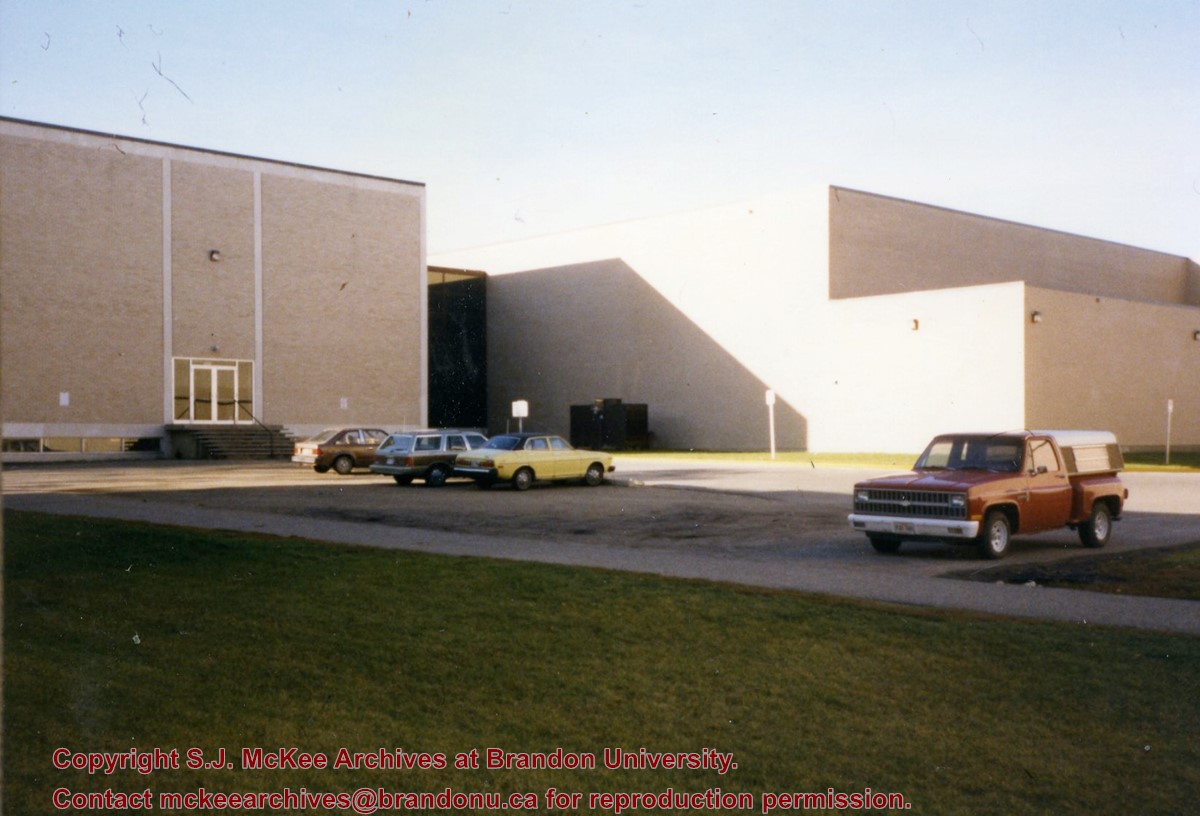
Photograph is looking southwest from in front of the Original Music Building and shows the north side of the A.E. McKenzie Building and the west side of the Queen Elizabeth II Music Building (including the link). A number of cars in the parking lot are also visible.
Images
Show Less

Brandon College campus from the north

http://archives.brandonu.ca/en/permalink/descriptions957
Part Of
Aerial views and campus photographs
Description Level
Item
GMD
graphic
Date Range
c. 1950s
Part Of
Aerial views and campus photographs
Description Level
Item
Series Number
2.1
Item Number
2.1.39
GMD
graphic
Date Range
c. 1950s
Physical Description
4.5" x 2.75" (b/w)
Scope and Content
View is southwest. Photograph shows: Clark Hall, the Brandon College Building and the Citizens' Science Building.
Images
Show Less

Brandon from river bend north

http://archives.brandonu.ca/en/permalink/descriptions11499
Part Of
CKX fonds
Description Level
Item
GMD
graphic
Date Range
after 1954
Accession Number
11-2010
Part Of
CKX fonds
Creator
CKX
Description Level
Item
Item Number
11-2010.B75
Accession Number
11-2010
GMD
graphic
Date Range
after 1954
Physical Description
1.5" x 1" (b/w)
Material Details
Negative
Custodial History
See fonds level of the CKX records for custodial history.
Scope and Content
Image of Brandon viewed from a bend in the Assiniboine River north of the city.
Name Access
CKX Television
Brandon, Manitoba
Subject Access
landscapes
Landscape Photography
Storage Location
CKX fonds - 2010 accessions
Images
Show Less

Transmitter building (1st Street North - radio)

http://archives.brandonu.ca/en/permalink/descriptions13013
Part Of
CKX fonds
Description Level
Item
GMD
graphic
Date Range
after 1954
Accession Number
11-2010
Part Of
CKX fonds
Creator
CKX
Description Level
Item
Series Number
T
Item Number
11-2010.T2
Accession Number
11-2010
GMD
graphic
Date Range
after 1954
Physical Description
5" x 4" (b/w)
Material Details
Negative
Custodial History
See fonds level of the CKX records for custodial history.
Scope and Content
Image of the radio transmitter building.
Name Access
CKX
Subject Access
broadcasting
Radio
building exteriors
Storage Location
CKX fonds - 2010 accessions
Images
Show Less

20 records – page 1 of 1.