In 1988 four units were excavated in Block G. The vegetation is similar to other areas in the locale with an open oak forest with a light understory of saskatoon, hazelnut, poison ivy and sarsaparilla.
Excavations recovered artifacts between 0 cm – 15 cm b.s. The cultural deposits are very shallow and it is quite possible that what appears to be a single occupation may in fact represent multiple occupation compressed deposits as a result of deflation or the lack of sedimentation in this raised area. This latter view is supported by the ceramics which appear to be a mixture of Blackduck and Vickers Focus wares.
The frequency and distribution of cultural material from block G contrasts with that of other sites in the locale. While the diagnostic materials are similar, the nature of the background debris and the associated lithic assemblage suggests that this area was utilized for a different set of activities.
Unlike Blocks E and H, there is very little in the way of ceramics, fire-cracked rock or bison bone, yet a significant amount of lithic debitage and six Plains/Prairie Side-notched projectile points were recovered. No unifaces or scrapers were recovered. This may be an area where activities such as manufacture and hafting of projectile points; hunting activities, butchering and refuse disposal took place.
No RC dates were taken.
Scope and Content
Sub-sub-sub series contains: Summary information of field methology, number and co-ordinates of excavations, personnel and their staff position; Field journals are daily records of recoveries, features and activities at the site; Site records include excavation level and unit summaries, feature sheets, profiles; sample records and maps; Artifact catalogues are lists and identifications of all artifacts recovered; Photographs are of excavation units, features, the landscape and personnel.
The vegetation in block H is similar to other areas in the locale with an open oak forest with a light understory of saskatoon, hazelnut, poison ivy and sarsaparilla.
The excavations of the eight 1m2 units in 1988 resulted in the recovery of over 650 ceramic fragments including 20 rim sherds from at least four vessels, a grooved maul, fire-cracked rock, lithic debitage and a reworked Avonlea projectile point. A large amount of bison bone, including a number of axial elements and a fragmented skull were also recovered.
Based on the 1988 recoveries at the site further excavations took place in 1991. Nine excavation units were opened next to the previous excavations. Another 250 ceramic sherds were recovered in 1991. Nine vessels have been identified based on rim sherds. Vickers Focus and Woodland vessels have been identified and two vessels similar to Scattered Village Complex were recovered.
The lithic material assemblage is intermediate between Blocks G and E with KRF being the most frequent material category followed by local cherts.
Two features, a hearth and a curvilinear arrangement of rock were recovered. The high numbers of ceramic fragments suggests a habitation area, rather than hunting or butchering behavior. However, the separation of occupations at the site is difficult to establish and there may be different uses of the site by successive occupations.
Radiocarbon dates from this block indicate two occupations separated in time by some 300 years. XU 181 – 405/110 BP and XU 184 – 780/110 BP.
Scope and Content
Sub-series has been divided into sub sub series including: Lovstrom Block H 1988 and Lovstrom Block H 1991.
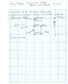
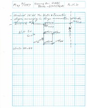
Block B consisted of 20 contiguous 1m2 units excavated to 30 cm below surface. (except unit 58 which was excavated to 35 cm bs to obtain extended soil profile). The block is situated in recent oak and poplar forest at the head of a ravine leading to Jock’s Creek, adjacent to an area cleared for market gardening. As was the case with Block A, the understory is heavily overgrown with hazelnut, chokecherry, saskatoon, and a poison ivy/sarsaparilla ground cover.
The soil levels below the sod in Block B consisted of a black, silty, and gritty loam layer from 5 cm to 23 cm below surface, a yellow and sandy clay from 23 cm to 30 cm below surface, and glacial till at 30 cm below surface. As in Block A, limestone cobbles were found throughout the occupation level around the bone. It is evident that bioturbation – primarily tree roots and rodent burrowing – have significantly altered patterns of original deposition of lithics, ceramics and small bone.
The faunal layer lay close to the surface, situated entirely in the black loam 5 cm – 23 cm below surface. The 23 cm depth also marked the end of the dark silty loam. At 10 cm below surface, a discernible patterning of the bone appeared. Concentrations of bone in narrow rows ran in an irregular pattern from the northwest to the southeast part of the block. This pattern was most apparent in the north end of the block which is the highest point in the block. In the same 1m2 unit, patches of weathered, very poorly preserved bone would be found lying close to patches of well preserved bone. It is believed that this variability in preservation results from uneven rates of burial due to taphic activities of pocket gophers or other agents of bioturbation. The same pattern of uneven preservation occurs over much of the locale but is most evident in Block B.
Diagnostic lithics included eleven projectile points that were predominantly Plains or Prairie Side-notch types, but included two unnotched triangular points. Cord-wrapped impressed rim sherds and body sherds were recovered. The ceramics are variants of the Woodland Blackduck horizon.
RC dates: XU49 – 675/80 BP XU 59 – 705/75BP.
Scope and Content
Sub-sub-sub series contains: Summary information of field methology, number and co-ordinates of excavations, personnel and their staff position; Field journals are daily records of recoveries, features and activities at the site; Site records include excavation level and unit summaries, feature sheets, profiles; sample records and maps; Artifact catalogues are lists and identifications of all artifacts recovered; Photographs are of excavation units, features, the landscape and personnel.
The Atkinson site was named for the landowners Ken and Karen Atkinson who were very helpful to the archaeology and geoarchaeology crews that worked at the site. Their support made the project possible.
The Atkinson site story begins with the discovery of a charcoal lens eroding from the north bank of the Souris River in the summer of 2002. Study of Cultural Adaptations on the Prairie Ecozone (SCAPE) project geoarchaeologist Dr. Garry Running was exploring the stratigraphic layering in the bank when he noted the lens and reported it to Dr. Bev Nicholson. Upon closer examination, a tiny pressure flake was observed on the lens exposure and it was decided to collect a charcoal sample for radiocarbon dating.
The resulting date of 5250B.P cal. 4225 B.C. placed the site in the early Archaic period. A second date on bone collagen of 5580B.P. cal. 4500 B.C. confirmed the earlier date and gave an averaged date of circa 4400 B.C or 6,500 years ago.
The Atkinson site is one of the oldest excavated sites in Manitoba. Based on the date of the site and the kind of lithics (stone tools) present it is considered a Gowen occupation. The Atkinson site is evidence that bison hunters were active on the northern plains at a very early date. Similar sites have also been found on the High Plains in the U.S. and are referred to as the Mummy Cave Complex.
The Atkinson Site is of great importance as it is the first undisturbed site of this type to be excavated in Manitoba and extends the range of these sites south and east from the type-sites in central Saskatchewan. Based on the date and sample evidence further excavations were conducted by Dr. Nicholson's team. in 2003, 2004 and 2006.
Scope and Content
Sub series has been divided into three sub sub series including: (1) Atkinson 2003, (2) Atkinson 2004; (3) Atkinson 2006
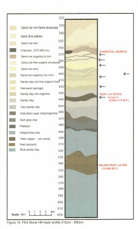
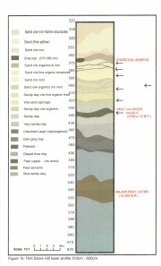
Flintstone Hill is located on the north bank of the Souris River. It is a deeply stratified lacustrine, fluvial and aeolian soil profile that has been exposed by the river through stream-bank erosion. This section is thought to be the most complete middle to late Holocene exposure on the northeastern plains. While the value of the site is primarily for paleo-environmental research and reconstruction, cultural deposits have been identified at the site. Local collectors have picked up lithic materials as they eroded out of the bank for the past several decades and it was they who had named the site. Mr. Bruce Timms from Lauder first drew the Flintstone Hill site to the attention of Dr. Nicholson of Brandon University.
During the mid 1990’s to the early 2000’s archaeological testing took place on Flintstone Hill. In 1998, an archaeological field crew dug a series of overlapping trenches down the slope of the profile and produced a schematic drawing. A peat layer at the bottom of this profile, dated from the top at 9,400 RCY and at the bottom to 10,400 RCY, has provided details of marsh plant and insect communities at this time.
Subsequent archaeological investigations at the site recovered several cultural deposits including: a hearth dating to 3250+/-70 R.C.Y. (BETA 109529); a butchered atlas bone 4090+/-70 R.C.Y. (BETA 109990); and bone fragments accompanied by Swan River Chert and Knife River Flint lithic flakes 5350+/-50 (BETA 109530). While no diagnostic tools were recovered, these dates suggest that this occupation, which is contemporary with the Atkinson site, may be a Gowen occupation.
Extensive paleo-environmental research has been conducted at the site. Dr. Running, a geomorphologist from the University of Wisconsin – Eau Claire, participated in the Study of Cultural Adaptations in the Prairie Ecozone (SCAPE) Project and he and his students tested the site for several years. He was joined in this effort by Dr. Havholm, Dr. Boyd, Dr. Wiseman, Dr. Beaudoin, and other SCAPE researchers in the interpretation of the paleo-environment of the Glacial Lake Hind basin. The following article is recommended reading.
Running, Garry L., Karen G. Havholm, Matt Boyd and Dion J. Wiseman
2002 Holocene Stratigraphy and Geomorphology of Flintstone Hill, Lauder Sandhills, Glacial Lake Hind Basin, Southwestern Manitoba. Geographie Physique et Quaternaire
56(2-3):291-303.
Scope and Content
Sub series has been divided into two sub sub series including: (1) Flintstone Hill 1997 (2) Flintstone Hill 1998-2000
The Duthie site is the first site identified in the Makotchi-Ded Dontipi locale. It was reported to Dr. Bev Nicholson by Doug Jackson, a local collector who had observed archaeological materials that had been exposed during the construction of Maple Hill Road northwest of Lauder. The site is named after the landowner, Randy Duthie.
The initial inspection of the exposed materials indicated that the eastern half of the site had been severely impacted by raising a road grade using an elevating grader. However, an undetermined amount of the site remained to the west, flanked by a low sand dune. Testing and preliminary excavations were conducted in 1992-93. In 1994 a field school added to the excavated sample. The undisturbed portion of the site, west of Maple Hill Road was situated at the base of a low sand dune and had an aspen and willow forest cover. The water table was approximately one meter below surface at the time of excavation. A rising water table has since prevented further excavations.
Two dates on bone collagen were obtained during excavations. These were 880+/-80 B.P. (Beta 62705) and 970+/-40 B.P. cal. 1030 A.D. (TO 13366). These dates are consistent with an Initial Middle Missouri cultural assignment. The site occupation is identified by the distinctive ceramics found there. Ceramics at the Duthie Site are tool impressed with incising and lip modeling with fabric impressions on most vessels. Jill Taylor analysed the ceramics from the site for a Specialist thesis, Brandon University (1994) and a Masters of Arts degree from the University of Saskatchewan. (Taylor 1995).
Analysis of residue from Duthie site pottery by Matthew Boyd recovered corn (Zea mays) phytoliths and bean (Phaseolus sp.) starch grains indicating consumption of these domesticates at the Duthie site. (Boyd 2006)
The occupation of this site indicates a migration of people from the south who were well acquainted with horticultural farming. These people had previously migrated to South Dakota following river valleys into the central plains from the eastern woodlands during late Hopewell times. It appears that they later migrated well to the north into southern Manitoba but there is no evidence that they remained there for more than a single year.
Boyd, M., C. Surette and B.A. Nicholson. 2006 Archaeobotanical Evidence of Prehistoric Maize (Zea mays) Consumption at the Northern Edge of the Great Plains. Journal of Archaeological Science 33: 1129-1140.
Taylor, J. 1994 An analysis of the ceramics recovered during 1992 and 1993 at the Precontact Duthie Site (DiMe-16). Specialist thesis, Brandon University.
Scope and Content
The Series has been divided into seven sub-series, including (1) Duthie site (2) Jackson site (3) Twin Fawns site (4) Vera site (5) Schuddemat site (6) Bradshaw site (7) Hollow B site.
Cover of Young School minute book is moderately damaged, but pages are in good condition with only minor water damage and a few ripped pages.
History / Biographical
Dorothy Cox (nee Frost) moved from Elm Creek to Justice in 1946 to work as a schoolteacher. In 1948, she married Laval Cox and together they had four children: Larry, Herd, Rosalie and Heather.
In 1949, Dorothy and Laval purchased Gibb Gillespie's PSV business and began hauling grain, cattle and agricultural equipment. Dorothy went back to teaching in 1959, first at Justice and then Elton Collegiate. After retiring from teaching in 1978, Dorothy started a greenhouse, which operated for 21 years.
All six members of the Cox family were active in community events and organizations. Dorothy was involved in establishing the baby band in 1951; her sons Larry and Herb were members. Along with Laval, Dorothy was a leader of the Cubs in 1955-1956 and again in 1958-1959. Laval was the leader of the local hockey club in 1958, and of a bible study group in 1960. Larry, Herb and Rosalie were avid skaters in 1960-64. Heather and Rosalie were enrolled in senior grades of Sunday school in 1970.
Custodial History
Records were collected by Dorothy Cox, a resident of Justice, over a number of years. She donated them to the McKee Archives on April 4, 2012.
Scope and Content
Collection consists of records related to the history of the Justice district. It includes a history of the Justice Church (1910-1970); minute and expense books for the Justice Hockey Club (1949-1966); a minute and expense book for Young Protestant School (1884-1898); a copy of the Justice 100th Anniversary community history (2009); and four color photographs of Justice Church.
Notes
History/Bio information taken from the content of the collection. Description by James Heaman (2012).
Margaret Menzies was born on July 30th, 1920, at a family farm located in Oakburn, Manitoba. She grew up on the family farm and attended school in both Oakburn and Shoal Lake. She married Donald Menzies on June 4th, 1941. Together they had four children. In 1959, the family moved to Brandon, Manitoba, where they lived for the rest of their lives.
Margaret Menzies was a longtime and active member of the International Toastmistress Club (ITC), and was also involved in the Consumers Association of Canada, Seniors for Seniors, as well as being a member of the Liberal Party of Canada and the Central United Church. Menzies did not graduate from high school in her early years, but managed to continue her education and receive a bachelor of arts degree from Brandon University at the age of 70.
Margaret Menzies passed away on June 9th, 2012.
Custodial History
Records in the collection were brought to the S.J McKee Archives on July 13, 2012, by Gerald Brown, on behalf of the family of Margaret Menzies.
Scope and Content
Collection contains of two scrapbooks created by Margaret Menzies. The scrapbooks contain various cards, itinerary's, and other documents associated with Menzies' membership in the International Toastmistress Club. The items in the scrapbooks date from the mid 1980's to the late 1990's.
Also included in the collection are four local history books. The first is a 100 year history of the town of Oakburn, Manitoba, from 1870 to 1970, published during celebrations of Manitoba's centenniary in 1970. Next is a book about the history of the town of Shoal Lake, Manitoba, which was published in 1959 on the 50th anniversary of the founding of the town of Shoal Lake in 1909. The last two books are the first and second volumes of Ripples on the Lake, which cover the history of the Shoal Lake municipality from 1884. The first volume covers the first 100 years of the history of the Shoal Lake region, being published in 1984. The second volume was published in 2007, covering the history of Shoal Lake since 1984, as well as including new information that was not published in the 1984 version of the book.
Finally, the collection contains one photograph of Margaret Menzies receiving her bachelor of arts degree from Peter Hordern, dean of arts of Brandon University.
Notes
Biographical information provided by obituary entry in the Brandon Sun, June 16, 2012. Description by Tyler Warren (October 2012).