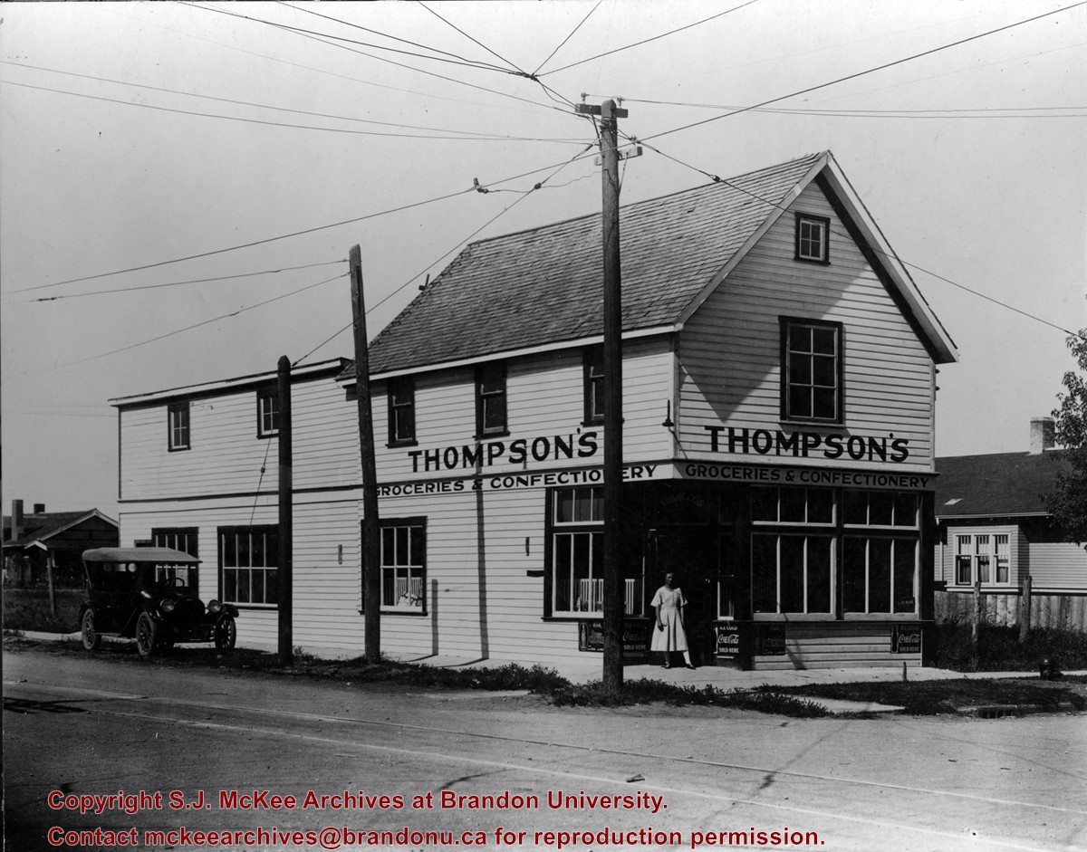
Thompson's Groceries and Confectionary was established in 1923 by Arthur Thompson (b. 1881 - d. May14, 1957) at 764 13th Street. From approximately 1925-1927, the store was operated by Alexander Thompson at 762 13th Street. The fate of the store from 1929-1935 is unclear. In 1929, Alexander Thompson was a grocer at 748 7th Street and in 1931 a Mrs. A Thompson was a grocer at 802 14th Street. There were two Thompson grocery and confectionary businesses in Brandon in 1933: Thompson's Confectionary at 745 13th Street and Thompson & Co. at 702 12th Street. In 1935, Arthur Thompson appears to have either taken over one of the earlier businesses or reopened his own grocery in its original location at 762 13th Street. He operated his store at this location into the mid-1950s. At some point following Thompson's death the building was bought by Frank Fitzpatrick and used for his upholstery store.
Custodial History
Donated by Frank Fitzpatrick.
Scope and Content
Photograph is looking northwest at the extrior of Thompson's Grocieries and Confectionary.
Notes
History/Bio information taken from Henderson's Directories (1917-1955) for Brandon, MB.
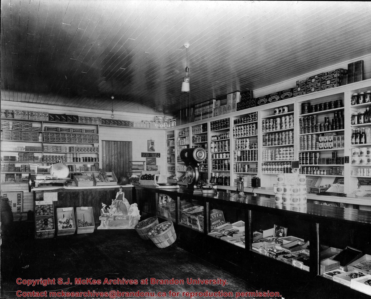
Thompson's Groceries and Confectionary was established in 1923 by Arthur Thompson (b. 1881 - d. May14, 1957) at 764 13th Street. From approximately 1925-1927, the store was operated by Alexander Thompson at 762 13th Street. The fate of the store from 1929-1935 is unclear. In 1929, Alexander Thompson was a grocer at 748 7th Street and in 1931 a Mrs. A Thompson was a grocer at 802 14th Street. There were two Thompson grocery and confectionary businesses in Brandon in 1933: Thompson's Confectionary at 745 13th Street and Thompson & Co. at 702 12th Street. In 1935, Arthur Thompson appears to have either taken over one of the earlier businesses or reopened his own grocery in its original location at 762 13th Street. He operated his store at this location into the mid-1950s. At some point following Thompson's death the building was bought by Frank Fitzpatrick and used for his upholstery store.
Custodial History
Donated by Frank Fitzpatrick.
Scope and Content
Photograph shows the interior of Thompson's Grocieries and Confectionary.
Notes
History/Bio information taken from Henderson's Directories (1917-1955) for Brandon, MB.
Image is looking east northeast from approximately the 300 block of 23rd Street between Lorne and Louise Avenues. Photograph shows the Brandon College campus after the opening of the original Music Building in 1963, but before the construction of the Education Building in 1966. A number of house on the 300 blocks of 22nd and 21st Streets are visible in the foreground, with the A.E. McKenzie Seed Co., the Prince Edward Hotel and various grain elevators on the horizon.
Photograph shows the removal of one of the houses formerly located on 20th Street between Louise and Princess Avenues. The houses on those blocks were removed to create parking lots for the University. A Fed Zavislak Ltd. Well Drilling & Trucking pickup truck is visible at the curb.
Photograph shows the removal of one of the houses formerly located on 20th Street between Louise and Princess Avenues. The houses on those blocks were removed to create parking lots for the University.
View is northeast from the Brandon College Building. Photograph shows the inside of the Brandon College Building after it had been gutted and then partially rebuilt. The exterior fascade of the west side of the building can be clearly seen in this photograph. A number of houses on the east side of 200 block of 18th Street are also visible, as is the stone fence on Princess Avenue and the flag pole on the front lawn.
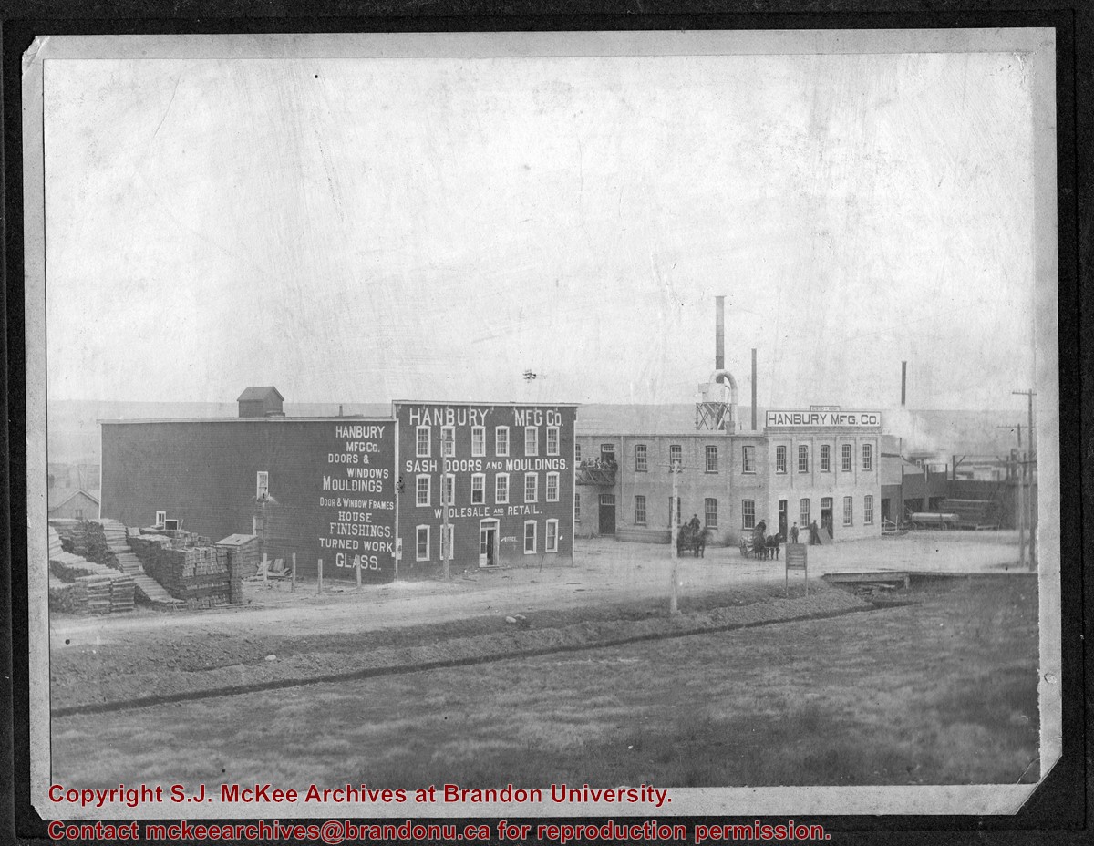
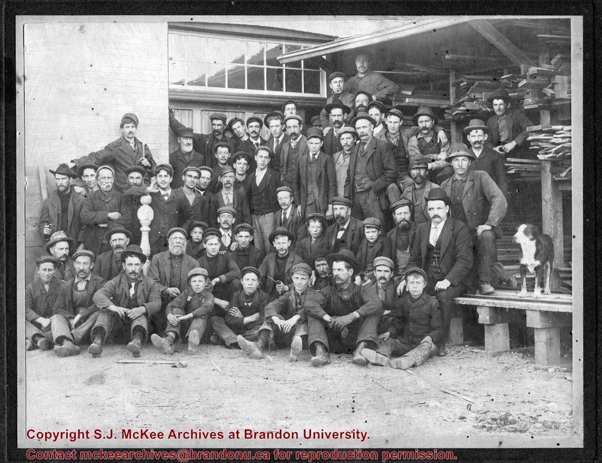
John Hanbury came to Brandon in January 1882. For the next decade he operated a contracting business, constructing several Brandon buildings including the post office, the Merchants Block, and the General Hospital. In 1892, Hanbury founded the Hanbury Manufacturing Company. The most important industry in Brandon from 1900-1914, Hanbury’s employed over 150 men in logging, lumbering and the manufacturing of doors, windows, furniture and other house fixtures.
With offices, a warehouse and lumber mill on either side of Assiniboine Avenue at 6th Street North, Hanbury’s relied on timber from northern forests that was moved, raft-like, down river by drivers. Cabinets, furniture and other millwork was sold out of the Hanbury Hardware Co. building on 7th Street and Pacific Avenue. John Hanbury left Brandon in 1910, although his son continued to operate the business until World War I.
Residential buildings were constructed on the company lands on Assiniboine Avenue west of 6th Street North in the late 1920s; the building east of 6th Street was used first as the Christie’s School Supplies warehouse (1929-1939) and then by successive woollen mills (1941-1991). A portion of what appears to be the original building currently stands vacant on the site. The hardware building on Pacific Avenue has been primarily used by the Government Liquor Control Commission (1929-1971) and Christie’s School Supplies, now Christie’s Office Plus (early 1940s – present).
Custodial History
Photos belonged to Jim Lanigan's family. He donated them to the McKee Archives in January 2017.
Scope and Content
Item is a photograph of the Hanbury Mfg Co. buildings on Assinboine Avenue - photo is looking northeast
Notes
Jim Lanigan and his siblings beleived that Hanbury Manufacturing Company is where their paternal grandfather James Joseph Lanigan worked and learned the glazing trade. James Joseph's father James and brother Albert Daniel may have also worked there. Both Joe and Bert went to work for the CPR in Brandon in 1898. Jim Lanigan could not identify any family members in the group portrait.
John Hanbury came to Brandon in January 1882. For the next decade he operated a contracting business, constructing several Brandon buildings including the post office, the Merchants Block, and the General Hospital. In 1892, Hanbury founded the Hanbury Manufacturing Company. The most important industry in Brandon from 1900-1914, Hanbury’s employed over 150 men in logging, lumbering and the manufacturing of doors, windows, furniture and other house fixtures.
With offices, a warehouse and lumber mill on either side of Assiniboine Avenue at 6th Street North, Hanbury’s relied on timber from northern forests that was moved, raft-like, down river by drivers. Cabinets, furniture and other millwork was sold out of the Hanbury Hardware Co. building on 7th Street and Pacific Avenue. John Hanbury left Brandon in 1910, although his son continued to operate the business until World War I.
Residential buildings were constructed on the company lands on Assiniboine Avenue west of 6th Street North in the late 1920s; the building east of 6th Street was used first as the Christie’s School Supplies warehouse (1929-1939) and then by successive woollen mills (1941-1991). A portion of what appears to be the original building currently stands vacant on the site. The hardware building on Pacific Avenue has been primarily used by the Government Liquor Control Commission (1929-1971) and Christie’s School Supplies, now Christie’s Office Plus (early 1940s – present).
Custodial History
Photos belonged to Jim Lanigan's family. He donated them to the McKee Archives in January 2017.
Scope and Content
Item is a group portrait of Hanbury Manufacturing Company employees.
Notes
Jim Lanigan and his siblings beleived that Hanbury Manufacturing Company is where their paternal grandfather James Joseph Lanigan worked and learned the glazing trade. James Joseph's father James and brother Albert Daniel may have also worked there. Both Joe and Bert went to work for the CPR in Brandon in 1898. Jim Lanigan could not identify any family members in the group portrait.
The overpass is named for Brandon's first mayor, Thomas Mayne Daly, and the street on which the overpass is located. The overpass opened in October 1963.
Scope and Content
Photograph is an aerial view of the Daly 18th Street Overpass (18th Street Bridge). Visible are a number of commercial and residential buildings in the north end of Brandon, MB. The view is northeast, probably taken from the roof of the old steam plant north of 20th Street and Rosser Avenue.
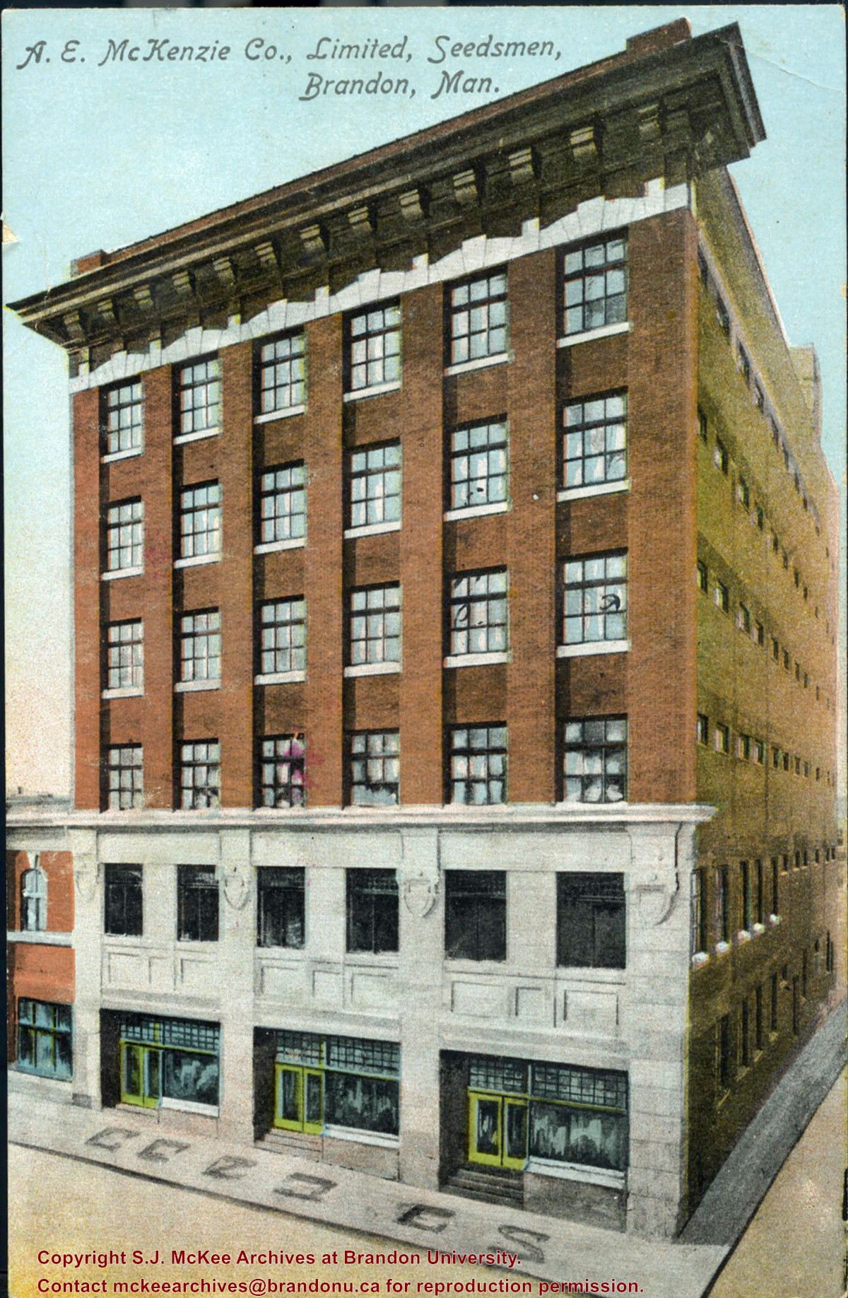
Postcard was donated to the McKee Archives by Allen Drysdale, archivist at Beautiful Plains Archives in October 2011. Drysdale received the postcard as part of a larger donation to his archives.
Scope and Content
Item is a colour postcard of the A.E. McKenzie Seed Company in Brandon, MB. The postcard was sent to John Dorset, Elphinstone, MB from his brother Sid (?).
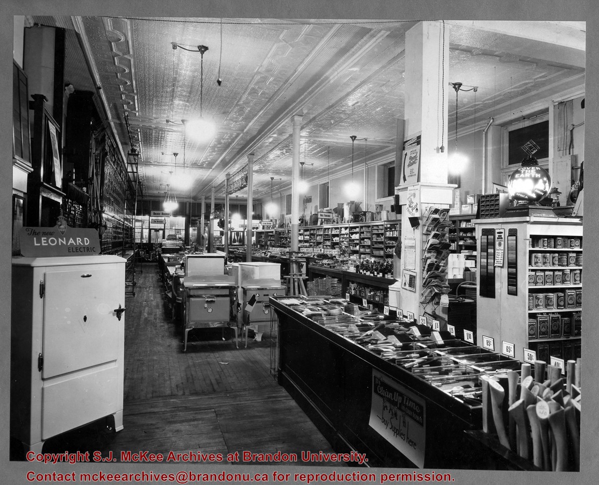
Brandon Hardware Co. Ltd. founded in 1882, making it one of Brandon's earliest mercantiles. It was incorporated in 1902, and their location on Rosser Avenue at the corner of 7th Street was constructed in 1903. For a number of years, J.B. Curran was the managing director. The building was destroyed by fire in 1983.
Custodial History
Katy Singleton was given this photo in her role as Heritage Coordinator for the City of Brandon. She transferred it to the McKee Archives in 2013.
Scope and Content
Item is a photograph of of the interior of the Brandon Hardware Co. Ltd. looking towards the front of the store from the back.
Brandon Hardware Co. Ltd. founded in 1882, making it one of Brandon's earliest mercantiles. It was incorporated in 1902, and their location on Rosser Avenue at the corner of 7th Street was constructed in 1903. For a number of years, J.B. Curran was the managing director. The building was destroyed by fire in 1983.
Custodial History
Katy Singleton was given this photo in her role as Heritage Coordinator for the City of Brandon. She transferred it to the McKee Archives in 2013.
Scope and Content
Item is a photograph of of the interior of the Brandon Hardware Co. Ltd. looking towards the back of the store from the front.
View is southwest from approximatley 16th Street between Princess and Rosser Avenues. Photograph shows the Brandon University campus, as well as surrounding residential blocks, including Flemming, J.R. Reid and Vincent Massey schools.
View is west southwest from approximatley 16th Street between Princess and Lorne Avenues. Photograph shows the Brandon University campus, as well as surrounding residential blocks between 16th and 23rd Streets, Princess and Louise Avenues..
View is west from approximatley 17th Street between Lorne and Louise Avenues. Photograph shows a portion of the Brandon University campus (excluding the Education Building and anything north of it), as well as surrounding residential blocks from approximatley 17th Street to 22nd Street.
View is west northwest from approximatley 16th Street and Louise Avenue. Photograph shows the Brandon University campus, prior to the Library Extension, and a large portion of the city to the west of the campus.
View is northeast probably from the roof of McMaster Hall. Photograph shows the construction of the new roof on Clark Hall and the Brandon College Building. A portion of the east side of the 000 and 100 blocks of 18th Street, as well as the corner of 18th Street and Rosser Avenue are visible in the upper left hand corner. This includes the "Downtown Brandon" sign.
View is north northeast probably from the roof of McMaster Hall. Photograph shows the construction of the new roof on Clark Hall and the Brandon College Building, as well as the construction of the extension to Clark Hall and the skywalk. Portions of the city as far north as the Assiniboine River are also visible.
View is north northeast from the roof of McMaster Hall. Photograph shows the campus under construction during the renovation of the Brandon College Building and Clark Hall. The photograph was taken in late fall after the roof had been removed from the buildings but before the construction of the extension of Clark Hall. Construction materials litter the courtyard and driveway. The view looking north extends to The North Hill - a number of residential blocks, particularly to the northeast of 18th Street are visible. Buildings include the International Harvester Building and Kin Village.
View is north northeast probably from the roof of McMaster Hall. Photograph shows the construction of the new roof on Clark Hall and the Brandon College Building, as well as the construction of the extension to Clark Hall and the skywalk. The view looking north extends to The North Hill - a number of residential blocks, particularly to the northeast of 18th Street are visible. Buildings include the International Harvester Building and Kin Village.


