Skip header and navigation

Revise Search

20 records – page 2 of 1.

Curries Landing (Assiniboine River)

http://archives.brandonu.ca/en/permalink/descriptions11132
Part Of
RG 11 Lawrence Stuckey fonds
Description Level
Item
GMD
graphic
Date Range
Apr. 12, 1977
Part Of
RG 11 Lawrence Stuckey fonds
Creator
L.A. Stuckey
Description Level
Item
Series Number
3.3
Item Number
1-2002.3.3.BSE[366a]
GMD
graphic
Date Range
Apr. 12, 1977
Physical Description
2.5" x 2.5"
Material Details
Negative
Custodial History
For custodial history see the collection level description of the Lawrence Stuckey collection.
Scope and Content
Image of Curries Landing (Assiniboine River).
Notes
[Brandon SE includes communities south of Trans-Canada #1 highway and east of PTH #10.]
Name Access
Curries Landing
Assiniboine River
Subject Access
Rivers
Storage Location
Lawrence Stuckey collection
Arrangement
[Mr. Stuckey put three negatives in the same envelope. We have separated them and numbered the negatives (366a) to(366c)].
Images
Show Less

Curries Landing (Assiniboine River)

http://archives.brandonu.ca/en/permalink/descriptions11134
Part Of
RG 11 Lawrence Stuckey fonds
Description Level
Item
GMD
graphic
Date Range
Apr. 12, 1977
Part Of
RG 11 Lawrence Stuckey fonds
Creator
L.A. Stuckey
Description Level
Item
Series Number
3.3
Item Number
1-2002.3.3.BSE[366b]
GMD
graphic
Date Range
Apr. 12, 1977
Physical Description
2.5" x 2.5"
Material Details
Negative
Custodial History
For custodial history see the collection level description of the Lawrence Stuckey collection.
Scope and Content
Image of Curries Landing (Assiniboine River).
Notes
[Brandon SE includes communities south of Trans-Canada #1 highway and east of PTH #10.]
Name Access
Curries Landing
Assiniboine River
Subject Access
Rivers
Storage Location
Lawrence Stuckey collection
Arrangement
[Mr. Stuckey put three negatives in the same envelope. We have separated them and numbered the negatives (366a) to(366c)].
Images
Show Less

Curries Landing (Assiniboine River)

http://archives.brandonu.ca/en/permalink/descriptions11135
Part Of
RG 11 Lawrence Stuckey fonds
Description Level
Item
GMD
graphic
Date Range
Apr. 12, 1977
Part Of
RG 11 Lawrence Stuckey fonds
Creator
L.A. Stuckey
Description Level
Item
Series Number
3.3
Item Number
1-2002.3.3.BSE[366c]
GMD
graphic
Date Range
Apr. 12, 1977
Physical Description
2.5" x 2.5"
Material Details
Negative
Custodial History
For custodial history see the collection level description of the Lawrence Stuckey collection.
Scope and Content
Image of Curries Landing (Assiniboine River).
Notes
[Brandon SE includes communities south of Trans-Canada #1 highway and east of PTH #10.]
Name Access
Curries Landing
Assiniboine River
Subject Access
Rivers
Storage Location
Lawrence Stuckey collection
Arrangement
[Mr. Stuckey put three negatives in the same envelope. We have separated them and numbered the negatives (366a) to(366c)].
Images
Show Less

West side of 10th Street from Princess Avenue, Brandon, Manitoba

http://archives.brandonu.ca/en/permalink/descriptions8401
Part Of
Joseph H. Hughes collection
Description Level
Item
GMD
graphic
Date Range
c. 1955
Accession Number
3-1997
Part Of
Joseph H. Hughes collection
Description Level
Item
Series Number
3-1997.1
Item Number
3-1997.1.23
Accession Number
3-1997
GMD
graphic
Date Range
c. 1955
Physical Description
8" x 10" (b/w)
Physical Condition
good
Scope and Content
Photograph of west side of 10th Street, Brandon, Manitoba, facing northwest. Visible businesses in the Alexandra Block include Doig's, Box Brothers Hardware and Allied Hardware Stores, followed by Simpsons-Sears and Barry Neill Men's Wear in the Strathcona Block. The Johnny Smith Block is visible in the background.
Name Access
Strathcona Block
Alexandra Block
Doig's
Box Brothers Hardware
Simpsons-Sears Ltd.
Barry Neill Men's Wear
10th Street
Subject Access
downtowns
street scenes
Brandon business buildings & facilities after 1940
building exteriors
Storage Location
RG 5 photograph storage drawer
Images
Show Less

10th Street from Princess Avenue facing north, Brandon, Manitoba

http://archives.brandonu.ca/en/permalink/descriptions8402
Part Of
Joseph H. Hughes collection
Description Level
Item
GMD
graphic
Date Range
c. 1955
Accession Number
3-1997
Part Of
Joseph H. Hughes collection
Creator
Photographer: Jerrett Photo
Description Level
Item
Series Number
3-1997.1
Item Number
3-1997.1.24
Accession Number
3-1997
GMD
graphic
Date Range
c. 1955
Physical Description
3.5" x 5.5" (b/w)
Material Details
postcard
Physical Condition
good
Scope and Content
Photograph of 10th Street facing north from Princess Avenue. Vehicles are parallel parked on both sides of the street. The Welcome Brandon sign can be seen at the Rosser Avenue intersection. Visible businesses on the west side of 10th Street include: Doig's, Box Brothers Hardware and Allied Hardware Stores in the Alexandra Block; followed by Simpsons-Sears in the Strathcona Block. Barry Neill Men's Wear, Kresge's and the Cecil Hotel are also visible. The Johnny Smith Block is visible in the background. 
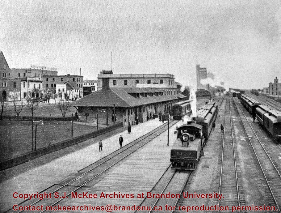
Visible businesses on the east side of 10th Street include: Ollies Steaks and Chops, Elna Sewing Centre, Carlton Cafe, Chop Suey. At the base of the hill the Canadian Pacific train station is visible at the base of the hill.
Notes
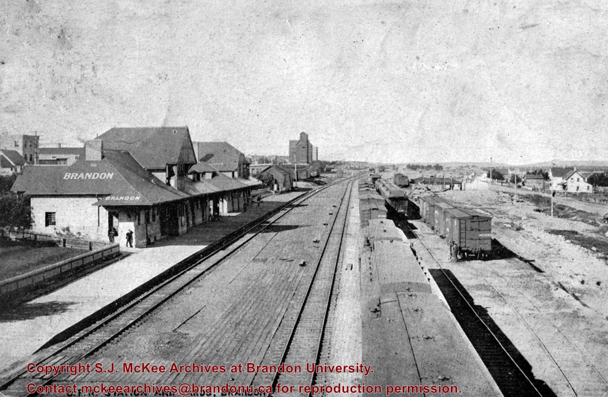
Writing on the front of the postcard reads: Tenth St. Brandon, Man.
Name Access
Strathcona Block
Alexandra Block
Doig's
Box Brothers Hardware
Simpsons-Sears Ltd.
Barry Neill Men's Wear
Kresge
Cecil Hotel
CPR Station
Ollies
Elna Sewing Centre
Carlton Cafe
10th Street
Subject Access
downtowns
street scenes
Brandon business buildings & facilities after 1940
building exteriors
Chinese restaurants
Storage Location
RG 5 photograph storage drawer
Images
Show Less

Princess Avenue facing east from 10th Street, Brandon, Manitoba

http://archives.brandonu.ca/en/permalink/descriptions8413
Part Of
Joseph H. Hughes collection
Description Level
Item
GMD
graphic
Date Range
c. 1965
Accession Number
3-1997
Part Of
Joseph H. Hughes collection
Description Level
Item
Series Number
3-1997.1
Item Number
3-1997.1.35
Accession Number
3-1997
GMD
graphic
Date Range
c. 1965
Physical Description
10" x 8" (b/w)
Physical Condition
good
Scope and Content
Photograph shows Princess Avenue facing east from 10th Street. On the north side of Princess Avenue, a B/A Service Station, Princess Cafe, Lindenberg Seeds, and the Central Fire Station are visible. Old City Hall with the war memorial and the Prince Edward Hotel are visible on the south side of Princess Avenue. Traffic is travelling one-way on Princess Avenue.
Name Access
Princess Avenue
City Hall
Prince Edward Hotel
B/A Service Station
Princess Cafe
Lindenberg Seeds
Central Fire Station
Subject Access
downtowns
street scenes
Brandon business buildings & facilities after 1940
building exteriors
hotels
garages
service stations
cafes
memorials
Storage Location
RG 5 photograph storage drawer
Images
Show Less

Aerial view of 10th Street facing south from Princess Avenue

http://archives.brandonu.ca/en/permalink/descriptions8420
Part Of
Joseph H. Hughes collection
Description Level
Item
GMD
graphic
Date Range
c.1940
Accession Number
3-1997
Part Of
Joseph H. Hughes collection
Creator
Photographer: Jerrett Photo
Description Level
Item
Series Number
3-1997.1
Item Number
3-1997.1.42
Accession Number
3-1997
GMD
graphic
Date Range
c.1940
Physical Description
5.5" x 3.5" (b/w)
Material Details
postcard
Physical Condition
Red ink stain is on the front right corner of postcard
Scope and Content
Photograph shows 10th Street facing south from Princess Avenue. Visible landmarks and businesses include: Manitoba Power Commission (MPC)'s power sub-station, First Baptist Church, Wheat City Arena, and the grand stand at the Exhibition Grounds. The partial sign visible at the bottom of the photograph on the east side of 10th Street reads Yates and Neale, which refers to a plumbing and heating company that dissolved in 1943 to be replaced by Neale, Stothard and Chapman. Businesses on the west side of 10th Street include: Dominion Tire & Radio Co., Bolts Barber Shop, Elviss T.E. Co. Stables.
Notes
Information concerning Yates and Neale courtesy Jack Stothard. Writing on the front of the postcard reads: Brandon, Looking S.W., Jerrett Photo. This photograph shows a rare view of the 200-block of 10th Street.
Name Access
Manitoba Power Company
10th Street
Dominion Tire & Radio Co.
T.E. Elviss Co. Stables
First Baptist Church
Subject Access
downtowns
street scenes
Brandon business buildings & facilities before 1940
aerial views
building exteriors
residences
churches
Storage Location
RG 5 photograph storage drawer
Images
Show Less
Part Of
RG 11 Lawrence Stuckey fonds
Description Level
Item
GMD
graphic
Date Range
[n.d.]
Accession Number
1-2002
Part Of
RG 11 Lawrence Stuckey fonds
Creator
Clarke J. Smith, Brandon
Description Level
Item
Series Number
3.9
Item Number
1-2002.3.9.14
Accession Number
1-2002
GMD
graphic
Date Range
[n.d.]
Physical Description
9.75" x 6.75" (b/w)
Custodial History
Photograph was found by Al Mitchell, a City of Brandon employee.
Scope and Content
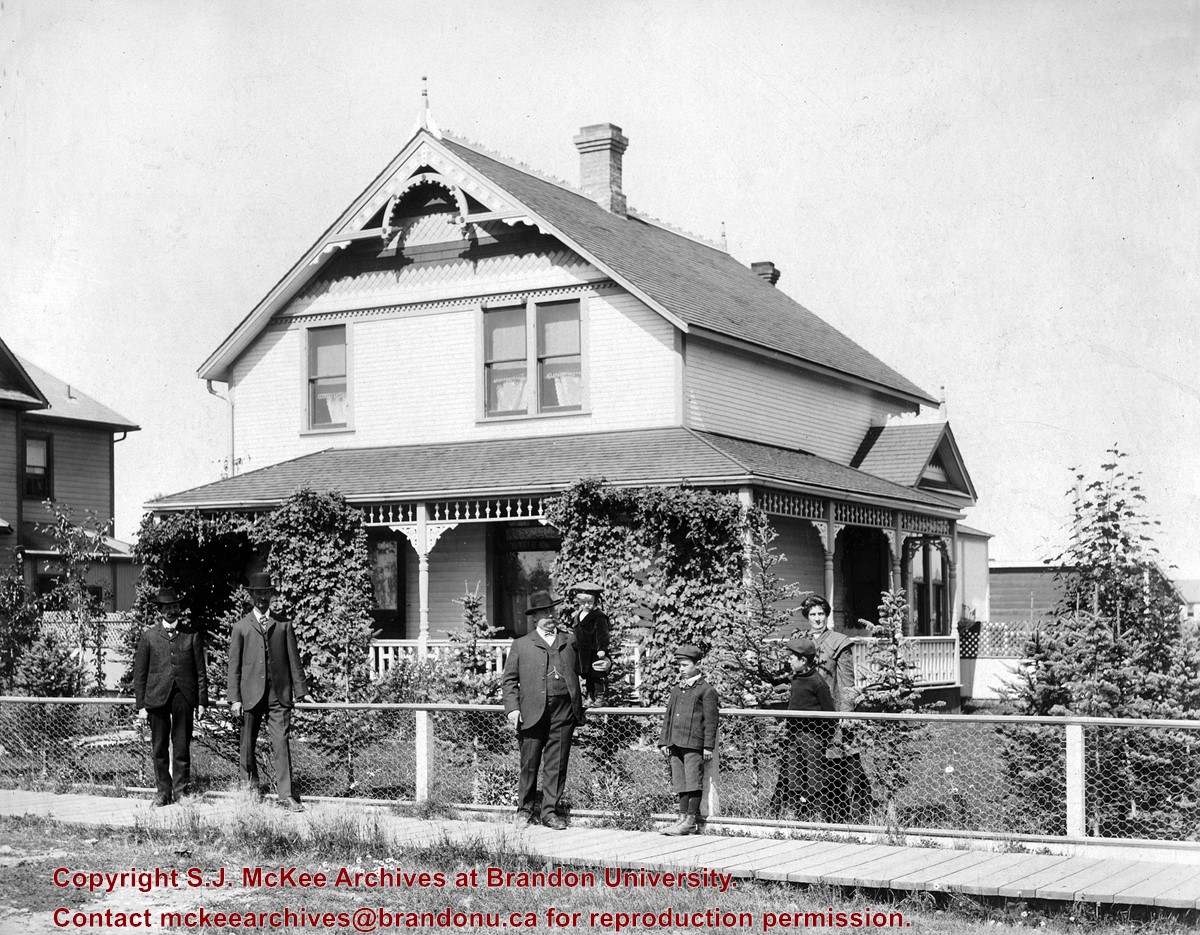
Photograph shows a family residence in the city. Four adults (three men and one woman) and three male children are standing at the property's fence or on the wooden sidewalk.
Repro Restriction
The McKee Archives is the copyright holder for the Stuckey materials.
Storage Location
RG 5 photograph storage drawer
Images
Show Less
Part Of
RG 11 Lawrence Stuckey fonds
Description Level
Item
GMD
graphic
Date Range
c. 1966
Accession Number
1-2002
Part Of
RG 11 Lawrence Stuckey fonds
Creator
Lawrence Stuckey
Description Level
Item
Series Number
3.9
Item Number
1-2002.3.9.26
Accession Number
1-2002
GMD
graphic
Date Range
c. 1966
Physical Description
4.5" x 3.25" (b/w)
History / Biographical
The original City Hall was located on Princess Avenue between 8th and 9th Streets.
Scope and Content
Photograph is looking south southwest and shows the main entrance of City Hall.
Repro Restriction
The McKee Archives is the copyright holder for the Stuckey materials.
Location Original
1-2002.3.1D2
Storage Location
RG 5 photograph storage drawer
Images
Show Less
Part Of
RG 11 Lawrence Stuckey fonds
Description Level
Item
GMD
graphic
Date Range
c. 1966
Accession Number
1-2002
Part Of
RG 11 Lawrence Stuckey fonds
Creator
Lawrence Stuckey
Description Level
Item
Series Number
3.9
Item Number
1-2002.3.9.27
Accession Number
1-2002
GMD
graphic
Date Range
c. 1966
Physical Description
4.5" x 3.25" (b/w)
History / Biographical
The original City Hall was located on Princess Avenue between 8th and 9th Streets.
Scope and Content
Photograph is looking east southeast from 9th street and shows the the west side of City Hall. The Beaubier Hotel is in the background.
Repro Restriction
The McKee Archives is the copyright holder for the Stuckey materials.
Storage Location
RG 5 photograph storage drawer
Images
Show Less

CPR station from bridge

http://archives.brandonu.ca/en/permalink/descriptions8780
Part Of
RG 11 Lawrence Stuckey fonds
Description Level
Item
GMD
graphic
Date Range
1913
Accession Number
1-2002
Part Of
RG 11 Lawrence Stuckey fonds
Description Level
Item
Series Number
3.9
Item Number
1-2002.3.9.155
Accession Number
1-2002
GMD
graphic
Date Range
1913
Physical Description
7.5" x 4.5" (b/w)
History / Biographical
Stuckey's notes: From a 1913 publication. Photo was current as engine 6127 is in 1912 renumbering.
Scope and Content
Photograph is looking west along the CPR tracks.
Notes
Corresponds with negative 1-2002.3.9.P10.
Repro Restriction
The McKee Archives is the copyright holder for the Stuckey materials.
Location Original
1-2002.3.1P10
Storage Location
RG 5 photograph storage drawer
Images
Show Less

Assiniboine River Bridge North of Kemnay

http://archives.brandonu.ca/en/permalink/descriptions9920
Part Of
RG 11 Lawrence Stuckey fonds
Description Level
Item
GMD
graphic
Date Range
[ca. 1938]
Accession Number
1-2002
Part Of
RG 11 Lawrence Stuckey fonds
Creator
George H. Harris
Description Level
Item
Series Number
3.1
Item Number
1-2002.3.1OB5(1)
Accession Number
1-2002
GMD
graphic
Date Range
[ca. 1938]
Physical Description
2 1/2" x 2 1/2"
Material Details
Negative
History / Biographical
This bridge was condemned in the late 1930s but cyclists continued to use it until it was torn down (approximately 1940)
Until the early 1920s the Canadian Pacific Railway maintained a well and pumping station near the southeast corner of this bridge, which pumped water through a pipeline to a locomotive watering tank at Kemnay.
Custodial History
For custodial history see the collection level description of the Lawrence Stuckey collection.
Scope and Content
Assiniboine River Bridge North of Kemnay
Notes
[Mr. Stuckey put a negative and print in the same envelope. We have separated them, numbering the negative OB5(1) and the print OB5(1a).]
Name Access
Assiniboine River Bridge North of Kemnay
Subject Access
manmade geographic features
bridges
Brandon Area Bridges
Repro Restriction
The McKee Archives is the copyright holder for the Stuckey materials.
Storage Location
Lawrence Stuckey collection
Images
Show Less

Assiniboine River Bridge North of Kemnay

http://archives.brandonu.ca/en/permalink/descriptions9921
Part Of
RG 11 Lawrence Stuckey fonds
Description Level
Item
GMD
graphic
Date Range
[ca. 1938]
Accession Number
1-2002
Part Of
RG 11 Lawrence Stuckey fonds
Creator
George H. Harris
Description Level
Item
Series Number
3.1
Item Number
1-2002.3.1OB5(1a)
Accession Number
1-2002
GMD
graphic
Date Range
[ca. 1938]
Physical Description
2 1/2" x 2 1/2"
Material Details
Photograph
History / Biographical
This bridge was condemned in the late 1930s but cyclists continued to use it until it was torn down (approximately 1940)
Until the early 1920s the Canadian Pacific Railway maintained a well and pumping station near the southeast corner of this bridge, which pumped water through a pipeline to a locomotive watering tank at Kemnay.
Custodial History
For custodial history see the collection level description of the Lawrence Stuckey collection.
Scope and Content
Assiniboine River Bridge North of Kemnay
Notes
[Mr. Stuckey put a negative and print in the same envelope. We have separated them, numbering the negative OB5(1) and the print OB5(1a).]
Name Access
Assiniboine River Bridge North of Kemnay
Subject Access
manmade geographic features
bridges
Brandon Area Bridges
Repro Restriction
The McKee Archives is the copyright holder for the Stuckey materials.
Storage Location
Lawrence Stuckey collection
Images
Show Less

CPR station from overhead bridge

http://archives.brandonu.ca/en/permalink/descriptions8776
Part Of
RG 11 Lawrence Stuckey fonds
Description Level
Item
GMD
graphic
Date Range
c. 1904
Accession Number
1-2002
Part Of
RG 11 Lawrence Stuckey fonds
Creator
Photographer: Martel
Description Level
Item
Series Number
3.9
Item Number
1-2002.3.9.151
Accession Number
1-2002
GMD
graphic
Date Range
c. 1904
Physical Description
7" x 4.25" (b/w)
History / Biographical
Stuckey's notes: note Brandon Brewery not yet built.
Scope and Content
Photograph is looking west along the CPR tracks.
Notes
Corresponds with negative 1-2002.3.9.P6.
Repro Restriction
The McKee Archives is the copyright holder for the Stuckey materials.
Location Original
1-2002.3.1P6
Storage Location
RG 5 photograph storage drawer
Images
Show Less

CPR depot from overhead bridge

http://archives.brandonu.ca/en/permalink/descriptions8777
Part Of
RG 11 Lawrence Stuckey fonds
Description Level
Item
GMD
graphic
Date Range
c. 1905
Accession Number
1-2002
Part Of
RG 11 Lawrence Stuckey fonds
Description Level
Item
Series Number
3.9
Item Number
1-2002.3.9.152
Accession Number
1-2002
GMD
graphic
Date Range
c. 1905
Physical Description
7" x 4.25" (b/w)
History / Biographical
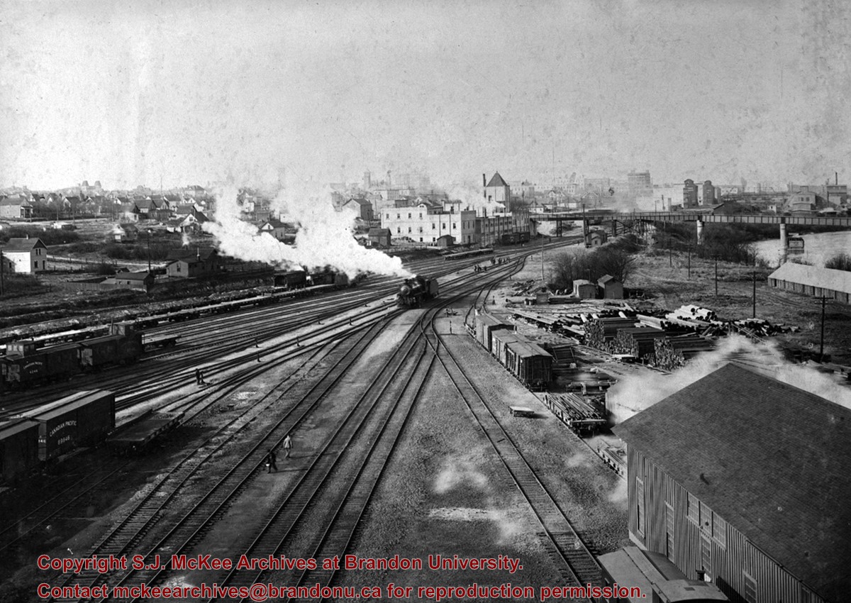
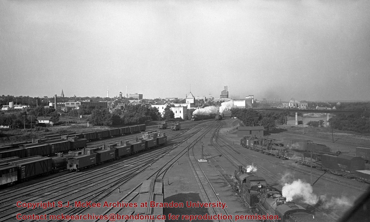
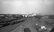
Stuckey's notes: Including Fraser Building, Brandon Brewery, EBD. through freight on mainline. Brandon Brewery (L. background) built 1905, razed 1939. Copy from postcard.
Scope and Content
Photograph is looking west along the CPR tracks.
Notes
Corresponds with negative 1-2002.3.9.P7.
Repro Restriction
The McKee Archives is the copyright holder for the Stuckey materials.
Location Original
1-2002.3.1P7
Storage Location
RG 5 photograph storage drawer
Images
Show Less

CPR station from east side

http://archives.brandonu.ca/en/permalink/descriptions8794
Part Of
RG 11 Lawrence Stuckey fonds
Description Level
Item
GMD
graphic
Date Range
February 15, 1981
Accession Number
1-2002
Part Of
RG 11 Lawrence Stuckey fonds
Creator
Photographer: Lawrence Stuckey
Description Level
Item
Series Number
3.9
Item Number
1-2002.3.9.168
Accession Number
1-2002
GMD
graphic
Date Range
February 15, 1981
Physical Description
6.5" x 4.5" (b/w)
History / Biographical
Stuckey's notes: Built 1911.
Scope and Content
Photograph is looking north west from the wouth side of Pacific Avenue and shows the east side of the CPR station.
Notes
Corresponds with negative 1-2002.3.9.P23.
Repro Restriction
The McKee Archives is the copyright holder for the Stuckey materials.
Location Original
1-2002.3.1P23
Storage Location
RG 5 photograph storage drawer
Images
Show Less

CPR Yards - from Water Tank

http://archives.brandonu.ca/en/permalink/descriptions9936
Part Of
RG 11 Lawrence Stuckey fonds
Description Level
Item
GMD
graphic
Date Range
[ca. 1912]
Accession Number
1-2002
Part Of
RG 11 Lawrence Stuckey fonds
Creator
Davidson & Gowen
Description Level
Item
Series Number
3.1
Item Number
1-2002.3.1P13
Accession Number
1-2002
GMD
graphic
Date Range
[ca. 1912]
Physical Description
3 1/2" x 5"
Material Details
Negative
Custodial History
For custodial history see the collection level description of the Lawrence Stuckey collection.
Scope and Content
Canadian Pacific Railway yards, Brandon
Notes
View from water tank.
[For original plate, please see the Alf Fowler collection of the S.J. McKee Archives 6-1999.49. P.E.]
Name Access
CPR Yards
Subject Access
railroads
railways
freight trains
locomotives
Canadian Pacific Railway in Brandon
Repro Restriction
The McKee Archives is the copyright holder for the Stuckey materials.
Storage Location
Lawrence Stuckey collection
Images
Show Less

CPR Yards - from Coal Dock

http://archives.brandonu.ca/en/permalink/descriptions9939
Part Of
RG 11 Lawrence Stuckey fonds
Description Level
Item
GMD
graphic
Date Range
September 1938
Accession Number
1-2002
Part Of
RG 11 Lawrence Stuckey fonds
Creator
George H. Harris
Description Level
Item
Series Number
3.1
Item Number
1-2002.3.1P16
Accession Number
1-2002
GMD
graphic
Date Range
September 1938
Physical Description
3 1/2" x 5"
Material Details
Negative
Custodial History
For custodial history see the collection level description of the Lawrence Stuckey collection.
Scope and Content
Canadian Pacific Railway yards, looking west from coal dock
Notes
[Eastbound passenger train] No. 54, a Moose Jaw - Winnipeg local, is leaving (just east of 1st St. Bridge)
Original negative
From the collection of George H. Harris, Winnipeg, Man.
Name Access
CPR Yards
Subject Access
railroads
railways
freight trains
passenger trains
locomotives
cabooses
Canadian Pacific Railway in Brandon
Repro Restriction
The McKee Archives is the copyright holder for the Stuckey materials.
Location Copy
1-2002.3.9.160
Storage Location
Lawrence Stuckey collection
Images
Show Less
Part Of
RG 11 Lawrence Stuckey fonds
Description Level
Item
GMD
graphic
Date Range
c. 1970
Accession Number
1-2002
Part Of
RG 11 Lawrence Stuckey fonds
Creator
Lawrence Stuckey
Description Level
Item
Series Number
3.9
Item Number
1-2002.3.9.145
Accession Number
1-2002
GMD
graphic
Date Range
c. 1970
Physical Description
8" x 7.5" (b/w)
History / Biographical
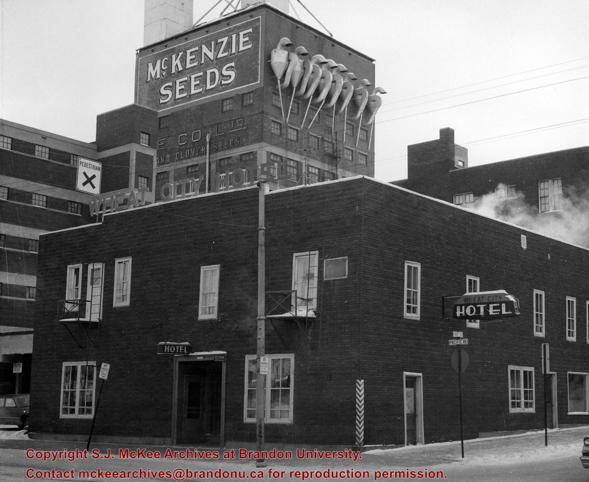
The Wheat City Hotel was located at the southeast corner of the intersection of 10th Street and Pacific Avenue.
Scope and Content
Photograph is looking southeast from the northside of Pacific Avenue and shows the main entrance to the hotel. Two of the windows on the north side of the hotel have the word "parlor" written on them. McKenzie Seeds is in the background.
Repro Restriction
The McKee Archives is the copyright holder for the Stuckey materials.
Storage Location
RG 5 photograph storage drawer
Images
Show Less

Brandon City Police

http://archives.brandonu.ca/en/permalink/descriptions9080
Part Of
RG 11 Lawrence Stuckey fonds
Description Level
Item
GMD
graphic
Date Range
1913
Accession Number
1-2002
Part Of
RG 11 Lawrence Stuckey fonds
Description Level
Item
Series Number
3.1
Item Number
1-2002.3.1AC4
Accession Number
1-2002
GMD
graphic
Date Range
1913
Physical Description
3 1/2" x 5"
Material Details
Negative
Custodial History
For custodial history see the collection level description of the Lawrence Stuckey collection.
Scope and Content
City of Brandon Police Department, 1913
Notes
Reproduction by D.L. Bottley
Name Access
Brandon City Police
Subject Access
law enforcement
policing
Brandon politicians & civil servants
Repro Restriction
The McKee Archives is the copyright holder for the Stuckey materials.
Storage Location
Lawrence Stuckey collection
Images
Show Less

20 records – page 2 of 1.