Skip header and navigation

Revise Search

20 records – page 1 of 1.

Edward Walker fonds

http://archives.brandonu.ca/en/permalink/descriptions4888
Part Of
RG 5 Western Manitoba Manuscript Collection
Description Level
Fonds
GMD
graphic
Date Range
1896-1920; predominant 1896-1910
Accession Number
24-2006
Part Of
RG 5 Western Manitoba Manuscript Collection
Description Level
Fonds
Accession Number
24-2006
GMD
graphic
Date Range
1896-1920; predominant 1896-1910
Physical Description
55 glass plate negatives (52 at 5x7; 3 at 3X5)
History / Biographical
Edward Walker was born in Lymm, Cheshire, England in 1836. He emigrated to Canada at age 59 in 1895, from Stockport, England. Walker came to Canada with three of his children - Dora, Daisy and Theo - and settled in Millwood, Manitoba. In childhood, Walker was a victim of polio and walked with the aid of two canes throughout his adult life. Walker was a professional photographer. Once in Canada, he also took out a homestead at N.W. 18-19-229, though it appears that his son Theo did most of the work required to gain title to the property. In addition to his work as a photographer, Walker was appointed post-master for Millwood in 1901, and operated a small store. Edward Walker retired as postmaster in 1920. He died in 1923.
Custodial History
The Walker fonds arrived at the S.J. McKee Archives as part of the Lawrence Stuckey Collection in 2001. While the circumstances are not known, it seems evident that Stuckey acquired the Walker negatives in the course of his professional career as a photographer and collector.
Scope and Content
Fonds contains a variety of images of Millwood, Manitoba and the surrounding agricultural community, its people, and life produced by Edward Walker in the course of his work as a professional photographer. These images were produced from gelatin dry plate negatives, a process introduced around 1880, to replace the wet collodin process in which a photographic solution was applied to a glass plate just prior to exposure. Edward Walker’s pictorial account of life in and around Millwood Manitoba circa 1900, is an important photographic legacy of pioneer life on the upper reaches of the Assiniboine Valley. The village of Millwood was located in the Assiniboine River valley close to the Manitoba-Saskatchewan border just a few miles northwest of Binscarth and a similar distance southwest of Russell. It came into existence in 1887, with the construction of the Manitoba and North-Western Railway, a road that ran diagonally through the new West from Prince Albert, North West Territories to Portage la Prairie Manitoba.
Notes
Description by Tom Mitchell.
Storage Location
2006 accessions
Storage Range
2006 accessions
Related Material
Several prints were located with the Walker Negatives. These were created by Lawrence Stuckey and have been located with the Lawrence Stuckey collection and identified as "Edward Walker" prints. RG 6, 8.2.4 (Library - S.J. McKee Archives - Archival displays).
Arrangement
Edward Walker – Millwood negatives 1. Manitoba and Northwestern railway steam shovel loading flat cars for the “fill” c. 1900 2. Completed “fill” near Millwood c. 1900 3. Steam shovel filling flat cars for the “fill” 4. Boy and pony 5. Farmer in field 6. Portrait – man 7. Portrait – man and woman 8. Portrait – man and women 9. Portrait – man 10. Portrait – little girl 11. Baseball game in progress 12. Cottage home 13. Portrait – man 14. Portrait – little girl 15. Gentlemen, horse and dog. 16. Portrait – two men 17. Portrait – mother and daughter 18. Mill and new Mill elevators c. 1896 19. Horse power in harness 20. Construction of railway bridge 21. Construction railway bridge 22. First automobile Millwood 23. Man, horse, carriage 24. Horse, sled filled with dead moose 25. Harvest scene reaper in action 26. Aboriginal people, tee pee 27. North Western railway bridge over the Assiniboine c. 1900 28. Railway trestle near the “Clay Dump”, on west hill near Harrowby 29. Team of horse in harness drawing a sled 30. Boy, horse with steer tethered to horse’s tail 31. Horse drawn wagon with children, woman and dog
Show Less

Brandon University campus

http://archives.brandonu.ca/en/permalink/descriptions8026
Part Of
Aerial views and campus photographs
Description Level
Item
GMD
graphic
Date Range
c. 1996
Part Of
Aerial views and campus photographs
Description Level
Item
Series Number
2.1
Item Number
2.1.93
GMD
graphic
Date Range
c. 1996
Physical Description
6" x 4" (colour)
Scope and Content
View is east northeast from the sidewalk on the southeast corner of the George T. Richardson Centre (John R. Robbins Library). Photographs shows the campus during winter, including the Physical Plant and Development H-Huts, as well as the Brandon College Building and Clark Hall after the majority of the renovations were completed.
Images
Show Less

Brandon University campus

http://archives.brandonu.ca/en/permalink/descriptions8027
Part Of
Aerial views and campus photographs
Description Level
Item
GMD
graphic
Date Range
c. 1985
Part Of
Aerial views and campus photographs
Description Level
Item
Series Number
2.1
Item Number
2.1.94
GMD
graphic
Date Range
c. 1985
Physical Description
5" x 3.5" (colour)
Scope and Content
View is southwest from 18th Street, just north of the Brandon University sign. Tken during the summer, the photograph shows the front lawn, a portion of the flower bed, the Citizens' Science Building, the Knowles Douglas Students' Union Centre, the John R. Brodie Science Centre and McMaster Hall.
Images
Show Less

Brandon University campus

http://archives.brandonu.ca/en/permalink/descriptions8028
Part Of
Aerial views and campus photographs
Description Level
Item
GMD
graphic
Date Range
c. 1980s
Part Of
Aerial views and campus photographs
Description Level
Item
Series Number
2.1
Item Number
2.1.95
GMD
graphic
Date Range
c. 1980s
Physical Description
5" x 3.5" (colour)
Scope and Content
View is northeast. Photograph shows the green space before the Library extension in 1993. Brandon College Building and the Development H-Hut in the background.
Images
Show Less

Brandon University campus

http://archives.brandonu.ca/en/permalink/descriptions8029
Part Of
Aerial views and campus photographs
Description Level
Item
GMD
graphic
Date Range
c. 1988
Part Of
Aerial views and campus photographs
Description Level
Item
Series Number
2.1
Item Number
2.1.96
GMD
graphic
Date Range
c. 1988
Physical Description
5" x 3.5" (colour)
Scope and Content
View is northwest from the roof of the John R. Brodie Science Centre. Photograph shows part of McMaster Hall, the H-Huts, the Citzens' Science Building, the Brandon College Building and Clark Hall, the driveway, the J.R.C. Evans Lecture Theatre, the A.E. McKenzie Building and the Queen Elizabeth II Music Building.
Images
Show Less

Brandon University campus

http://archives.brandonu.ca/en/permalink/descriptions8030
Part Of
Aerial views and campus photographs
Description Level
Item
GMD
graphic
Date Range
c. early 1990s
Part Of
Aerial views and campus photographs
Description Level
Item
Series Number
2.1
Item Number
2.1.97
GMD
graphic
Date Range
c. early 1990s
Physical Description
4" x 6" (b/w)
Scope and Content
View is north from the Knowles Douglas Students' Union Centre looking down the driveway toward Princess Avenue.
Images
Show Less

Brandon University campus

http://archives.brandonu.ca/en/permalink/descriptions8031
Part Of
Aerial views and campus photographs
Description Level
Item
GMD
graphic
Date Range
c. 1995
Part Of
Aerial views and campus photographs
Description Level
Item
Series Number
2.1
Item Number
2.1.98
GMD
graphic
Date Range
c. 1995
Physical Description
6" x 4" (colour)
Scope and Content
View is northwest from the sidewalk on the west side of 18th Street. Photograph shows the John R. Brodie Science Centre sign, McMaster Hall and its entrance, the lawn in from of McMaster Hall, a portion of the Knowles Douglas Students' Union Centre and the Citizens' Science Building.
Images
Show Less

Brandon University campus

http://archives.brandonu.ca/en/permalink/descriptions8032
Part Of
Aerial views and campus photographs
Description Level
Item
GMD
graphic
Date Range
c. 2000
Part Of
Aerial views and campus photographs
Creator
Photographer: Sandy Black
Description Level
Item
Series Number
2.1
Item Number
2.1.99
GMD
graphic
Date Range
c. 2000
Physical Description
6" x 4" (colour)
Scope and Content
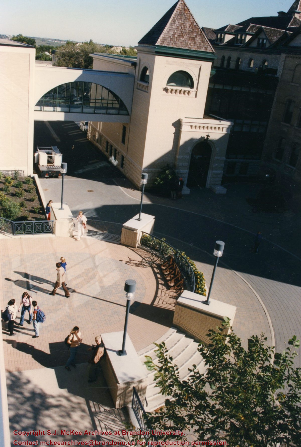
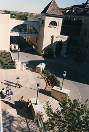
View is southwest from the corner of Clark Hall and the Clark Hall extension. Photograph shows students entering and exiting the George T. Richardson Centre and walking through the courtyard.
Images
Show Less

Brandon University campus

http://archives.brandonu.ca/en/permalink/descriptions8033
Part Of
Aerial views and campus photographs
Description Level
Item
GMD
graphic
Date Range
c. 1990s
Part Of
Aerial views and campus photographs
Description Level
Item
Series Number
2.1
Item Number
2.1.101
GMD
graphic
Date Range
c. 1990s
Physical Description
4" x 6" (colour)
Scope and Content
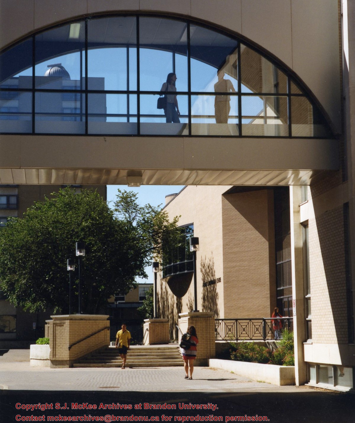
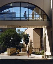
View is south from appromately the skywalk. Photograph shows the walkway that runs in front of the A.E. McKenzie Building south to the George T. Richardson Centre staircase and entrance. McMaster Hall in the background.
Images
Show Less

Brandon University campus

http://archives.brandonu.ca/en/permalink/descriptions8034
Part Of
Aerial views and campus photographs
Description Level
Item
GMD
graphic
Date Range
c. 2000
Part Of
Aerial views and campus photographs
Creator
Photograph: Sandy Black
Description Level
Item
Series Number
2.1
Item Number
2.1.102
GMD
graphic
Date Range
c. 2000
Physical Description
4" x 6" (colour)
Scope and Content
View is north northeast from the roof of the John E. Robbins Library in the George T. Richardson Centre. Photograph shows the entrance to the Richardson Building, part of the courtyard and the Clark Hall extension.
Images
Show Less

Brandon University campus

http://archives.brandonu.ca/en/permalink/descriptions8035
Part Of
Aerial views and campus photographs
Description Level
Item
GMD
graphic
Date Range
c. 2000
Part Of
Aerial views and campus photographs
Creator
Photographer: Sandy Black
Description Level
Item
Series Number
2.1
Item Number
2.1.103
GMD
graphic
Date Range
c. 2000
Physical Description
6" x 4" (colour)
Scope and Content
View is northeast from in front of the John E. Robbins Library in the George T. Richardson Centre. Photograph shows the entrance to the Richardson Building, most of the courtyard, Clark Hall and its extension.
Images
Show Less

Brandon University campus

http://archives.brandonu.ca/en/permalink/descriptions8036
Part Of
Aerial views and campus photographs
Description Level
Item
GMD
graphic
Date Range
c. 2000
Part Of
Aerial views and campus photographs
Creator
Photographer: Sandy Black
Description Level
Item
Series Number
2.1
Item Number
2.1.104
GMD
graphic
Date Range
c. 2000
Physical Description
6" x 4" (colour)
Scope and Content
View is northeast from the roof of the George T. Richardson Centre (John E. Robbins Library). Photograph shows the courtyard and the west side of the Brandon College building and Clark Hall, as well as the Clark Hall extension and part of the skywalk.
Images
Show Less

Brandon University campus

http://archives.brandonu.ca/en/permalink/descriptions8037
Part Of
Aerial views and campus photographs
Description Level
Item
GMD
graphic
Date Range
c. 2000
Part Of
Aerial views and campus photographs
Creator
Photographer: Sandy Black
Description Level
Item
Series Number
2.1
Item Number
2.1.105
GMD
graphic
Date Range
c. 2000
Physical Description
6" x 4" (colour)
Scope and Content
View is east southeast from the roof of the A.E. McKenzie Building. Photograph shows the courtyard and the west side of the Brandon College Building, as well as the Citizens' Science Building and the greenspace in between the two buildings.
Images
Show Less

Brandon University campus

http://archives.brandonu.ca/en/permalink/descriptions8038
Part Of
Aerial views and campus photographs
Description Level
Item
GMD
graphic
Date Range
c. 2000
Part Of
Aerial views and campus photographs
Creator
Photographer: Sandy Black
Description Level
Item
Series Number
2.1
Item Number
2.1.106
GMD
graphic
Date Range
c. 2000
Physical Description
4" x 6" (colour)
Scope and Content
View is from the front steps of the Education Building looking south down the east side of the Brandon College Building and Clark Hall to the Knowles Douglas Students' Union Centre and the John R. Brodie Science Centre in the background.
Images
Show Less

Brandon University campus

http://archives.brandonu.ca/en/permalink/descriptions8039
Part Of
Aerial views and campus photographs
Description Level
Item
GMD
graphic
Date Range
c. 2000
Part Of
Aerial views and campus photographs
Creator
Photographer: Sandy Black
Description Level
Item
Series Number
2.1
Item Number
2.1.107
GMD
graphic
Date Range
c. 2000
Physical Description
4" x 6" (colour)
Scope and Content
Photograph shows the Brandon College Building. It was taken from the sidewalk on 18th Street looking southwest across the front lawn.
Notes
Note on the back of the photograph reads "Please return photo to Sandy."
Images
Show Less

Brandon University campus

http://archives.brandonu.ca/en/permalink/descriptions8040
Part Of
Aerial views and campus photographs
Description Level
Item
GMD
graphic
Date Range
c. 2000
Part Of
Aerial views and campus photographs
Creator
Photographer: Sandy Black
Description Level
Item
Series Number
2.1
Item Number
2.1.108
GMD
graphic
Date Range
c. 2000
Physical Description
4" x 5" (colour)
Scope and Content
View is south. Photograph shows the skywalk and the steps leading to the entrance of the George T. Richardson Centre.
Images
Show Less

Brandon University campus

http://archives.brandonu.ca/en/permalink/descriptions8041
Part Of
Aerial views and campus photographs
Description Level
Item
GMD
graphic
Date Range
c. 1988
Part Of
Aerial views and campus photographs
Description Level
Item
Series Number
2.1
Item Number
2.1.110
GMD
graphic
Date Range
c. 1988
Physical Description
5" x 4" (colour)
Scope and Content
View is north northwest from the roof of McMaster Hall. Photograph shows part of the Citizens' Science Building, a number of H-Huts, the Brandon College Building, the greenspace, the J.R.C. Evans Lecture Theatre, the A.E. McKenzie Building, the Queen Elizabeth II Music Building and the Western Manitoba Centennial Auditorium. A number of residential blocks are also visible.
Images
Show Less

Brandon University campus

http://archives.brandonu.ca/en/permalink/descriptions8042
Part Of
Aerial views and campus photographs
Description Level
Item
GMD
graphic
Date Range
c. 1995
Part Of
Aerial views and campus photographs
Description Level
Item
Series Number
2.1
Item Number
2.1.111
GMD
graphic
Date Range
c. 1995
Physical Description
6" x 4" (b/w)
Scope and Content
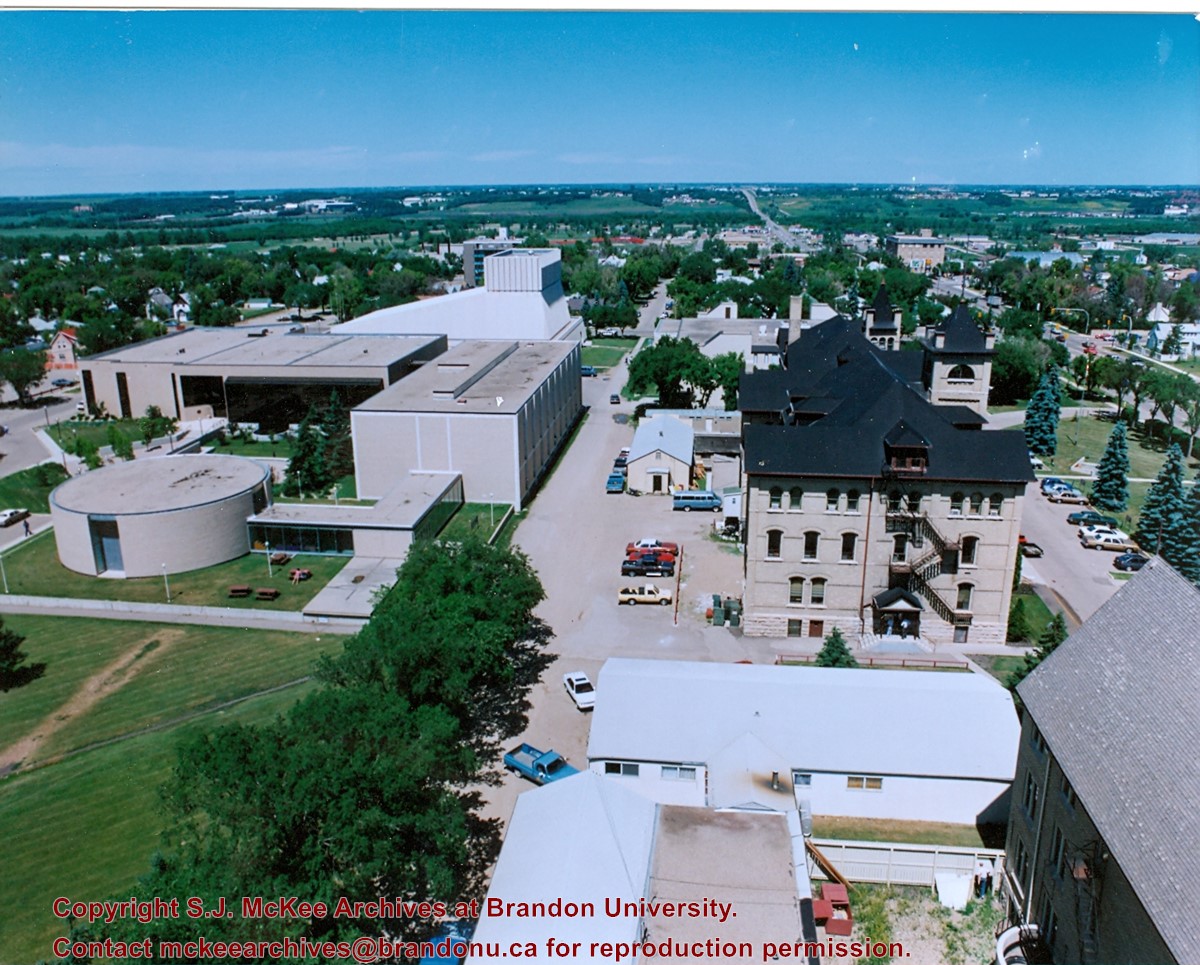
View is north northeast from the roof of McMaster Hall. Photograph shows a couple of H-Huts, the Brandon College Building, Clark Hall, the George T. Richardson Centre, the A.E. McKenzie Building, the original Music Building and the Western Manitoba Centennial Auditorium. A number of residential blocks are also visible.
Images
Show Less

Brandon University campus

http://archives.brandonu.ca/en/permalink/descriptions8043
Part Of
Aerial views and campus photographs
Description Level
Item
GMD
graphic
Date Range
c. 1995
Part Of
Aerial views and campus photographs
Description Level
Item
Series Number
2.1
Item Number
2.1.112
GMD
graphic
Date Range
c. 1995
Physical Description
4" x 6" (b/w)
Scope and Content
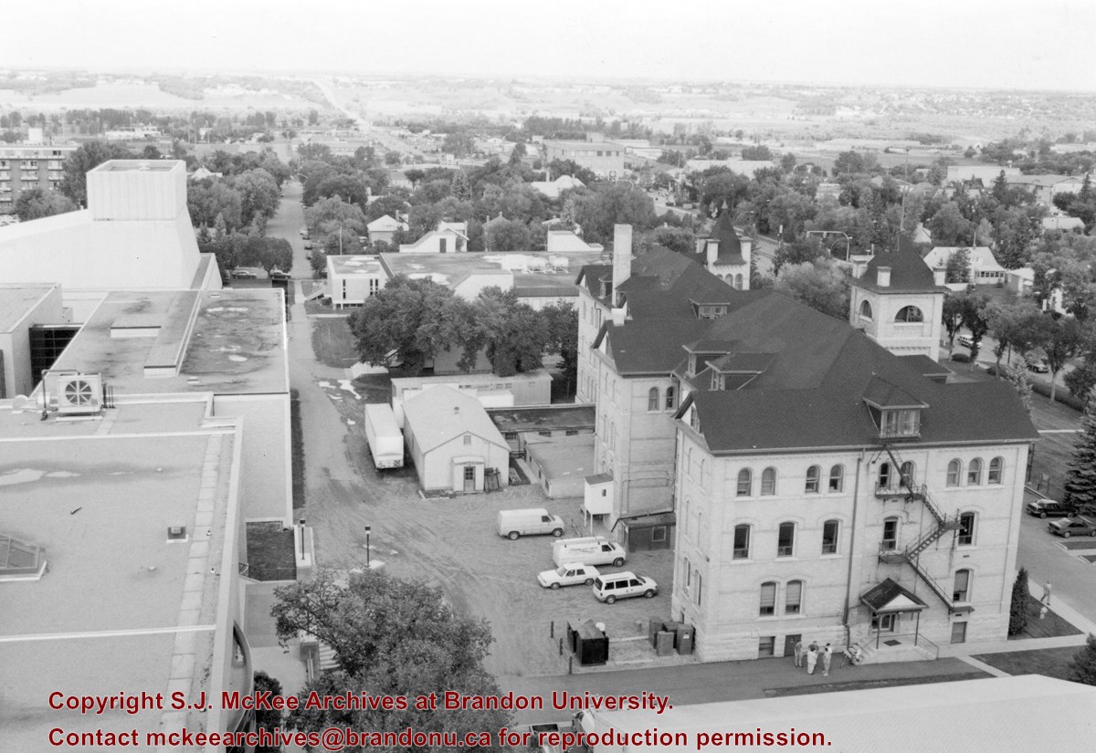
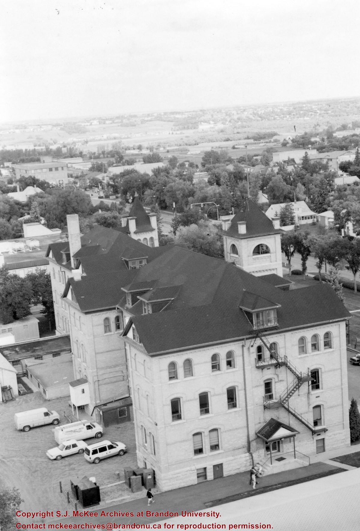
View is northeast from the roof of McMaster Hall. Photograph shows the Brandon College Building and Clark Hall, as well as the roof of the Education Building and portions of two H-Huts. A number of residential blocks are also visible.
Images
Show Less

Brandon University campus

http://archives.brandonu.ca/en/permalink/descriptions8044
Part Of
Aerial views and campus photographs
Description Level
Item
GMD
graphic
Date Range
c. 1972
Part Of
Aerial views and campus photographs
Description Level
Item
Series Number
2.1
Item Number
2.1.113
GMD
graphic
Date Range
c. 1972
Physical Description
5" x 3.5" (colour)
Scope and Content
View is northeast from the Dining Hall. Photograph shows the greenspace, the J.R.C. Evans Lecture Theatre, the A.E. McKenzie Building, the Brandon College Building and Clark Hall.
Images
Show Less

20 records – page 1 of 1.