9.46 m textual records; 1919 photographs & graphics
History / Biographical
Brandon, Manitoba was incorporated as a city in 1881. In 1882, led by Charles Whitehead and a small Board of Directors that included J.W. Vantassel, Charles Pilling, George Halse, J.E. Smith, William Johnson, R.T. Evans, and Thomas Lockhart, it was decided to hold an agricultural exhibition. These men were all involved in the farm business in one way or another, and they wanted an opportunity to help residents realize the agricultural potential of the region. In October of that year, the fledgling community held its first agricultural exhibition . The fair was held in downtown Brandon at what was known as “Market Square.” Market Square was two acres of land located on Princess Avenue between Eighth and Ninth Streets. Due to poor weather, and the fact that not many people were ready to show animals and grain, there was a relatively small turnout. The following year was much improved. There were 730 entries into the exhibition. By 1884, the Board of Directors of the Brandon Agricultural Society, which was in charge of the exhibition, realized that they were in poor financial shape, to the point of being personally out of pocket. It was realized that October was not the best time for farmers to be leaving their farms to go to an exhibition. In 1888, it was decided to move the exhibition to the summer time, when it was much easier for people to attend.
The first Brandon Summer Fair was held in July 1889, and it was a resounding success. The Board of Directors had added many items of interest to appeal to the entire public, not just agricultural people. In 1892, the Western Agricultural and Arts Association (WAAA) was formally established to take over duties from the Brandon Agricultural Society. However, it was not until 1897 that the WAAA held its first meeting. There is no explanation as to why there is a five year gap between the formation and the first meeting of this organization. 1897 was the turning point of the Brandon Exhibition. The fair was now firmly established in Brandon, and the Board of Directors was instrumental in ensuring that it remained so. This was done by petitioning to both the municipal and provincial governments for grant money. As well, the Board booked midway and grandstand acts that would bring the city dwellers to the agricultural exhibition.
There were also early attempts at holding an agricultural exhibition in the winter. The first such attempt was in 1884. There was also a Spring Stallion show held in 1891. By 1904, however, a petition by J.D. McGregor had gone out to formally establish a winter exhibition. This effort also failed, but by 1906, it was decided by businessmen, politicians, and farm representatives in Brandon, including McGregor, to organize a winter fair. Rather than seeing this new fair as competition, the Board of Directors of the summer fair felt that it would complement their exhibition. The new fair would remain primarily agricultural. The first winter fair was held in 1906. While the two fairs were not amalgamated, they did share the same secretary-manager. The secretary-manager was responsible for the day to day management of the fair, as well as keeping track of meetings and decisions reached by the various fair boards and committees. In 1907, the Brandon Winter Fair and Livestock Association (BWFLA) was formed to act primarily as a land-holding joint stock company. The following year the Provincial Winter Fair and Fat Stock Association (PWFFSA), an entirely separate organization from the BWFLA, was formed to manage the activities of the winter fair. The PWFFSA name was soon changed to the Manitoba Winter Fair and Fat Stock Association (MWFFSA).
By 1906, Brandon could boast two full size exhibitions, one in the summer and one in the late winter, both of which were considered to be premiere events. In 1908, the Brandon summer fair was renamed the Inter-Provincial Exhibition, and in 1912 it held it’s first Traveller’s Day, an event which would soon become an important addition to the fair and is still in existence today. It is thought that the name “Traveller’s Day” came from the fact that it was held on a Saturday, a day when many people could travel to Brandon for the exhibition.
In 1913, Brandon was bestowed with the honour of hosting the Dominion Exhibition. This was a national exhibition sponsored by the federal government. It was held in a different city every year. There were several cities vying for the 1913 Dominion Exhibition, but it was Brandon that impressed the sponsors the most. With the government funds received for this honour, the Board of Directors supervised the building of a new grandstand, display buildings, and racetrack, as well as the general expansion and improvements to the fairgrounds.
In the spring of 1912, it was decided by the Board of Directors of the winter fair that the facilities they were currently housed in were inadequate for their needs. The mayor and city clerk of Brandon went to the provincial legislature in order to request that there be an amendment added to the Brandon city charter. This amendment would allow the city to guarantee bonds issued by the winter fair board to help pay for the construction of a new facility. This request was granted, and a $70 000 addition was built next to the original winter fair building. The new building was opened in 1913.
Throughout the First World War, both the winter fair and Provincial Exhibition buildings were used for the war effort. There was one distinct difference however. The summer fair Board was able to negotiate a deal with the army that enabled it to reclaim the fair buildings during fair week. The winter fair, however, had to give up the idea of holding fairs in 1915 and 1916. It was not until 1917, that the winter fair was able to resume.
During this time, due to the financial problems that had beset the winter fair, the two exhibitions considered amalgamation. The Board of Directors of the winter fair felt that because they were the smaller of the two fairs, their interests would be swallowed up by the summer fair. The winter fair withdrew from the negotiations to amalgamate. With this rather sudden turn of events, the Board of Directors of the summer fair petitioned the government to be allowed to incorporate. This was granted, and in 1920, the WAAA was incorporated as the Provincial Exhibition of Manitoba. From 1920, the summer fair was officially known as the Provincial Exhibition of Manitoba. This was the first time that the summer fair was incorporated, and received the “status and financial assistance” that came with incorporation.
More problems beset the winter fair in the 1920s. In 1920, a fire burned down the winter fair pavilion, located at the south end of the winter fair buildings, and caused the Board to cancel the 1921 winter fair. It was not until 1922, that a new building was completed. By 1929, both fairs were well regarded throughout Canada. In 1929, a decade long Depression hit the west. While many fairs closed during this time, Brandon struggled to keep its open. The Directors of both fairs felt that the agricultural shows “encouraged excellence at a time when faith and enthusiasm were at a low ebb.” The summer fair proved to be quite successful during the Depression, likely as a result of the few moments one was able to forget one’s troubles while there. The winter fair was not quite as successful, although both fairs received government grants and work relief projects. There was little new entertainment in these exhibitions.
There were changes about to manifest themselves at the summer fair, however. While the winter fair had representatives from various associations on its Board of Directors, the summer fair Board of Directors was a small close-knit group of men. Citizens saw entry into this elite group as elusive and difficult. To ward off the possibility of the Board becoming a “self-sustaining clique,” that only chose Directors from within, it was decided by several citizens to try and elect some new blood into the fair Board. In 1933, there was a general election for the Board. Instead of the usual men shuffling positions, there were forty-four nominations for the twenty positions. When the voting was all over, seven new men sat on the Board. Despite some inner rumblings, especially on the summer fair Board over the next few years, both exhibitions survived the Depression.
During the Second World War the fairs once again were forced to operate under adversity. Once again, the buildings were requisitioned for the army, although they were released during fair week. The summer fair was forced to make several concessions, and the winter fair was relocated to the summer fair grounds for the duration.
The winter fair did not survive the Second World War intact. Due to financial reasons, in December of 1945, the Board of Directors turned the winter fair buildings over to the City of Brandon. By 1946, the BWFLA, which was the joint-stock land holding company, had ceased operations because the city now controlled the winter fair land and buildings.
The next fifteen years would be a time of rebuilding for both of Brandon’s exhibitions. Children especially were more active participants in the agricultural exhibitions. The summer fair continued to diversify and look for new ways of entertaining the public at large. The winter fair remained primarily agricultural. By the end of the 1950s the winter fair, which was used to struggling, was now both successful and stable; and the summer fair, a perennial success, was starting to fade.
By 1969, both the winter and summer fair Boards had realized that amalgamation was the best possible decision, both practically and financially, for the future of the two fairs. On 29 October, 1969, the two exhibitions amalgamated to become the Manitoba Exhibition Association. The reconstituted Provincial Exhibition of Manitoba was now responsible for both the winter and summer fairs. A new building was erected on the summer fair grounds to house both of the exhibitions. On 2 April 1973, the Keystone Centre was officially opened at the winter fair, although it had been in use since October of the preceding year.
In 1970, Manitoba’s Centennial, it was decided that an organization in Manitoba would receive the title of “Royal,” as a way to celebrate the centennial. Although many organizations applied for the honour, it was the Brandon winter fair that received the accolades. The winter fair was bestowed with the title “Royal”, and became known as the Royal Manitoba Winter Fair.
In 1975, a third exhibition was added, this time a purely agricultural fall show known as the Agricultural Exhibition, or AgEx. This fair was partly organized on behalf of the cattle growers, who found that the summer and winter fairs did not give them adequate time and space to properly show their cattle. The return to a fall show, which had not existed since 1888, would be the return to a purely agricultural exhibition. This show was to be primarily a show and sale event. On 3 November 1975, the first AgEx was opened to resounding success.
The Provincial Exhibition of Manitoba, the Royal Manitoba Winter Fair and AgEx are all still in existence in Brandon. They are regarded as three of the most important events to take place annually in the city.
Custodial History
These files were housed with the Manitoba Exhibition Association until c1986 when they were transferred to the S.J. McKee Archives at Brandon University.
Scope and Content
The fonds consists of textual records and photographs comprised of the records from the three annual exhibitions that are held in Brandon, Manitoba: the Provincial Exhibition of Manitoba, the Royal Manitoba Winter Fair, and the Agricultural Exhibition (Ag-Ex). The textual records include prize lists, programs, minutes, financial, administrative files, original results, scrapbooks, tickets, news releases, contracts, by laws, documents as well as a miscellaneous section. There are approximately 1846 photographs that include scenes from these three exhibitions. These records provide a unique perspective on the development of agriculture and rural life in southwestern Manitoba. Fairs such as these have been and remain prime media of farm improvement, technological and scientific advancement in rural Canada, and the promoters of country living. These fairs also reflected the long tradition inherited from Britain and Europe of country fairs as centers of entertainment, social interchange and diversion. These records are a principal source of information about the most broadly based vocational, entertainment and social events held on an annual basis in southwestern Manitoba over the last century. The records are vital to academic research on agriculture or fairs, individual biography, or community history.
Notes
The RG 2 Provincial Exhibition of Manitoba Association finding aid was created by Karyn (Riedel) Taylor with the exception of Series 9 and the accompanying database, which were created by Donica Belisle. This finding aid was created in August 1999.
Researchers are responsible for observing Canadian copyright restrictions.
Finding Aid
Available
Storage Location
RG 2 Provincial Exhibition of Manitoba Association fonds
Storage Range
RG 2 Provincial Exhibition of Manitoba Association fonds
Related Material
Additional records regarding the Provincial Exhibition of Manitoba, the Royal Manitoba Winter Fair, and AgEx are housed at the Provincial Exhibition of Manitoba Association offices. To gain access to these records, it is necessary to contact the general manager of the Provincial Exhibition of Manitoba Association.
Arrangement
The fonds is divided into sous-fonds by exhibition. There is a Provincial Exhibition sous-fonds, a Royal Manitoba Winter Fair sous-fonds, an Ag-Ex sous-fonds, and a Miscellaneous sous-fonds that holds information that could not be easily broken down into one exhibition. The arrangement is as follows:
RG 2 Provincial Exhibition Association of Manitoba fonds
RG2SF1 Provincial Exhibition of Manitoba
1.1 Documents
1.2 Minutes
1.3 Financial Records
1.4 Administrative Files
1.5 Prize Lists and Programs
1.6 News Releases
1.7 Original Results
1.8 Tickets
1.9 Photographs
1.10 Scrapbooks
1.11 Miscellaneous
RG2SF2 Royal Manitoba Winter Fair
2.1 Documents
2.2 Minutes
2.3 Financial Records
2.4 Administrative Files
2.5 Prize Lists and Programs
2.6 News Releases
2.7 Original Results
2.8 Tickets
2.9 Photographs
2.10 Scrapbooks
2.11 Miscellaneous
RG2SF3 AgEx
3.4 Administrative Files
3.5 Prize Lists and Programs
3.6 News Releases
3.7 Original Results
3.9 Photographs
RG2SF4 Miscellaneous
4.1 Documents
4.2 Minutes
4.3 Financial Records
4.4 Administrative Files
4.9 Photographs
4.10 Scrapbooks
4.11 Miscellaneous
Postcard shows the 100 block of 10th Street facing north. The CPR train station can be seen at the end of 10th Street. The sign for the Rex Cafe is visible on the west side of 10th Street. On the east side of 10th Street, billboards for Campbell & Campbell furniture are visible as well as signs for Pianos and the Orpheum Theatre. Motorists and cyclists share the road. Street car tracks run the length of 10th Street.
Notes
Back of postcard reads: Morning reflection of Brandon's skyline on the Assiniboine River, photo by Sandy Black, printed in Brandno, Manitoba, Canada by Leech Printing Ltd.
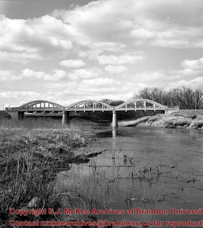
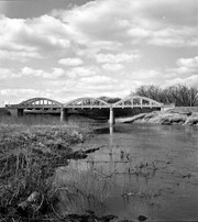
Kirkham's Bridge was built in 1906, to replace an earlier wooden bridge. The bridge was used until 1981, when it was purchased by the Town of Birtle and moved to a newsite. A former railway pridge was installed in its place.
Scope and Content
Photograph shows Kirkham's Bridge, a steel truss bridge that spanned the Little Saskatchewan River in the Municipality of Riverdale.
Notes
Identification of the bridge provided by Ken Storie (2023). Additional information taken from the Manitoba Historical Society website.
Situated in the R.M. of Whitehead on the Little Saskatchewan River, the 10 Mile Dam was a 14 kilometer transmission line that supplied the city of Brandon with power. The Brandon Electric Light Company built the dam in 1900 and it is considered Manitoba's first hydroelectic power generating station. The dam spanned approximately 80 meters and was constructed from timber and reinforced with clay and stone. The station was decommissioned in 1924.
Alonzo Archibald Rowe (b. 1862, London, ON; d. 22 Oct 1951, Brandon). The Rowes were considered Brandon area pioneers. Alonzo’s father, Alonzo L. Rowe, came to Brandon with his family in 1881, where the family had a furniture and undertaker business on the west side of 10th Street between Rosser and Princess Avenues. In 1885, the family began farming west of Brandon and Alonzo Archibald served as a councilor and then a reeve in the R.M. of Whitehead. He returned to Brandon in 1907 and served with the Brandon Police Department until 1910, when he returned to farming, this time in Arrow River. A.A. Rowe returned to Brandon in 1915 to work as a Provincial Licenses Inspector, a position he held until 1938. (Source: Obituary, Brandon Daily Sun 22 Oct 1951)
Custodial History
Photograph was in possession of Mrs. Ruby Miles, who passed the image on to Fred McGuinness. McGuinness makes reference to Mrs. Miles and this photograph in his Sunbeams column (Source: F.A. Rosser, "Another interesting chat with a daughter of the plains," Brandon Sun 18 Aug 1981).
Scope and Content
Photograph shows four fishermen at 10 Mile Dam, also known as the Brandon Dam or Minnedosa River Hydro Plant. The fishermen in the photo are identified as George H. Rowe and his father A.A. Rowe, Dr. Wilfred Bigelow, and Al Collins.
Notes
Writing on the back of the photograph reads: at Brandon Dam, [right to left] son and father - George H. ROWE, Mr. A.A. ROWE, Dr. BIGELOW, Al COLLINS (dam?, 1906?, George born March 1897); Jerrett's Photo-Services, May 7 1938.
Situated in the R.M. of Whitehead on the Little Saskatchewan River, the 10 Mile Dam was a 14 kilometer transmission line that supplied the city of Brandon with power. The Brandon Electric Light Company built the dam in 1900 and it is considered Manitoba's first hydroelectic power generating station. The dam spanned approximately 80 meters and was constructed from timber and reinforced with clay and stone. The station was decommissioned in 1924.
Scope and Content
Photograph shows 10 Mile Dam, also known as the Brandon Dam or Minnedosa River Hydro Plant.
Notes
Writing on the back of the photograph reads: "10 mile dam". Biographical information obtained from Manitoba Historical Society.
Situated in the R.M. of Whitehead on the Little Saskatchewan River, the 10 Mile Dam was a 14 kilometer transmission line that supplied the city of Brandon with power. The Brandon Electric Light Company built the dam in 1900 and it is considered Manitoba's first hydroelectic power generating station. The dam spanned approximately 80 meters and was constructed from timber and reinforced with clay and stone. The station was decommissioned in 1924.
Scope and Content
Photograph shows 10 Mile Dam, also known as the Brandon Dam or Minnedosa River Hydro Plant. The dam's timber construction is quite evident in the picture.
Notes
Writing on the back of the photograph reads: McGuinness (Manitoba Hydro), on Little Saskatchewan.
The Snye was a former channel (oxbow lake) of the Assiniboine River. It was located south of the Assiniboine between about 14th and 24th Streets, and during high water in the spring it carried overflow. For many years it was used as a log storage area for Hanbury's Mill. I remember there being bridges over it at 18th & 22nd Streets. It was dammed with a one way flipper valve at 14th Street that allowed water to flow out to the river, but prevented river water backing into it. Water within the Snye became stagnant in summer and formed a breeding area for mosquitoes. It was deemed a health hazard and the river was gradually filled in. LAS.
Custodial History
For custodial history see the collection level description of the Lawrence Stuckey collection.
Scope and Content
Snye River
Notes
[This negative was produced using a previous published image. P.E. 22/07/09]
Additional historical information provided by the Fred McGuinness collection (20-2009).
Erected by the village of Wawanesa, the memorial is dedicated to the local citizens who died as a result of the First and Second World Wars. It was unveiled on November 11, 1921.
Scope and Content
Photograph shows the dedication of a war memorial in the village of Wawanesa, MB. The memorial is located near the bank of the Souris River. The photograph was taken from Wawanesa Mutual. The street on the left is 4th Street.
Notes
History/Bio information taken from the Canadian National Defense website.


)
)
)