Field journals have been scanned in multi-page PDF files. Artifact catalogues are PDF files in spreadsheet format. Photographs are in jpeg format
History / Biographical
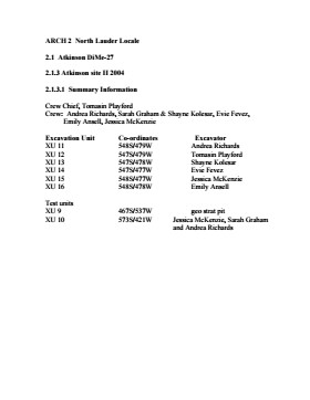
An area east of the Atkinson excavations was also opened for testing in 2004. This area was designated as Atkinson II and a test block was opened and fenced off from the cattle with snow fence. A 4m2 block was surveyed in (units 13 - 16) and two partial units that were truncated by the riverbank (units 11 &12) were also placed to the south of the 4m2 block. Test units 9 and 10 were also excavated.
Field journals have been scanned in multi-page PDF files. Artifact catalogues are PDF files in spreadsheet format. Photographs are in jpeg format
History / Biographical
Based on the results of the testing in 2002 and the radiocarbon date of 6,400 years before present, further excavation was warranted at the Atkinson I site. In 2003 Field Chief Holly Alston and crew Shayne Kolesar and Andrea Richards opened a 42m test excavation (units 1 - 4) that included the hearth area.
The unit co-ordinates and excavator are listed on the attached pdf file.
Field journals have been scanned in multi-page PDF files. Artifact catalogues are PDF files in spreadsheet format. Photographs are in jpeg format
History / Biographical
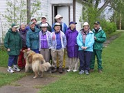
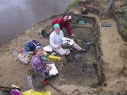
Over a period from 1997 to 2000 over 40 test pits were surveyed and five test units put in. Crew members included: Bev Nicholson, Scott Hamilton, Matt Boyd, Tomasin Playford, Lori Mokelki, T.J Hall, Rea Postoloski, Andy Belcourt, Jace Moon, Michelle Drysdale as well as others.
Field journals have been scanned in multi-page PDF files. Artifact catalogues are PDF files in spreadsheet format. Photographs are in jpeg format.
History / Biographical
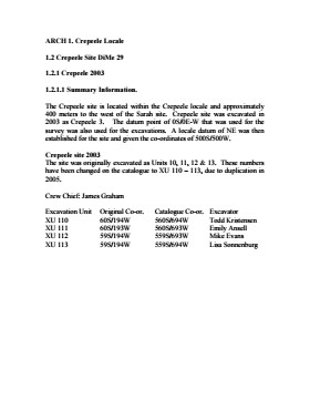
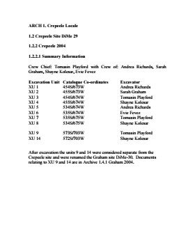
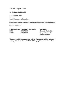
The Crepeele site was identified from the results of the Casselman survey. The site is located within the Crepeele locale approximately 400 meters to the west of the Sarah site. The units were excavated by Crew Chief James Graham and the crew from the survey.
The Crepeele site was excavated in 2003 as Crepeele 3 with the units numbered as units 10, 11, 12 & 13. These numbers have been changed on the catalogue to XU 110 – 113, due to duplication in 2005. Corresponding documents have been changed but there may be some reference to the initial numbers in the field journals.
The artifacts recovered from these four excavations are faunal (animal bone), mainly bison, lithic materials (stone tools and flakes) and some ceramic (pottery). The artifact catalogue has over 600 records.
Scope and Content
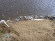
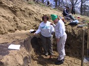
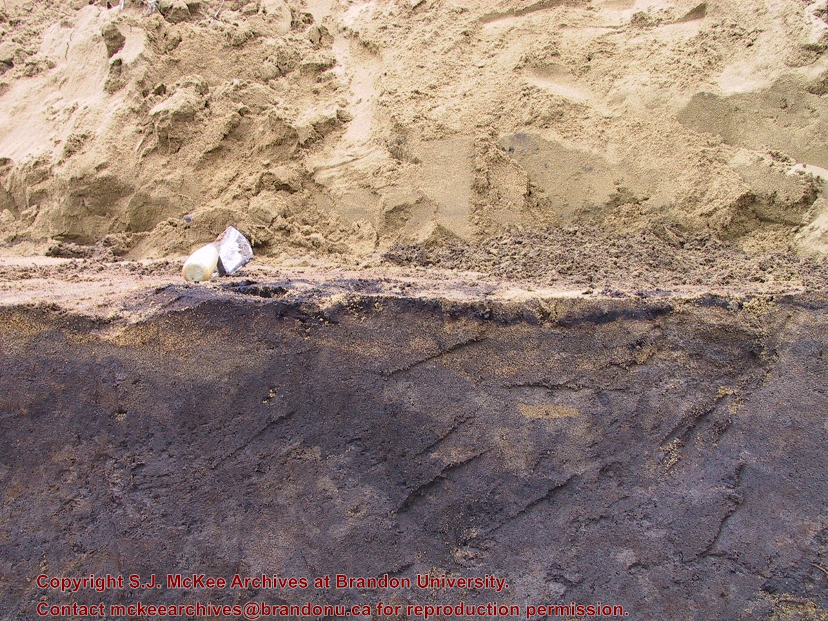
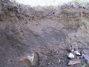
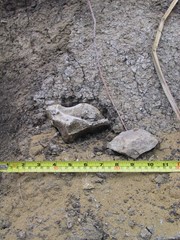
Sub-sub-sub series contains: Summary information of field methology, number and co-ordinates of excavations, personnel and their staff position; Field journalsare daily records of recoveries, features and activities at the site; Site records include excavation level and unit summaries, feature sheets, profiles; sample records and maps; Artifact catalogues are lists and identifications of all artifacts recovered; Photographs are of excavation units, features, the landscape and personnel.
Field journals have been scanned in multi-page PDF files. Artifact catalogues are PDF files in spreadsheet format. Photographs are in jpeg format.
History / Biographical
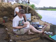
Archaeological testing began in the Crepeele locale in May 2003 with a field crew of four members. James Graham supervised the crew and was assisted by Sarah Graham, Jollana Bishop, and Lisa Sonnenburg. Later additions to the testing team were Todd Kristensen, Michael Evans, and Emily Ansell.
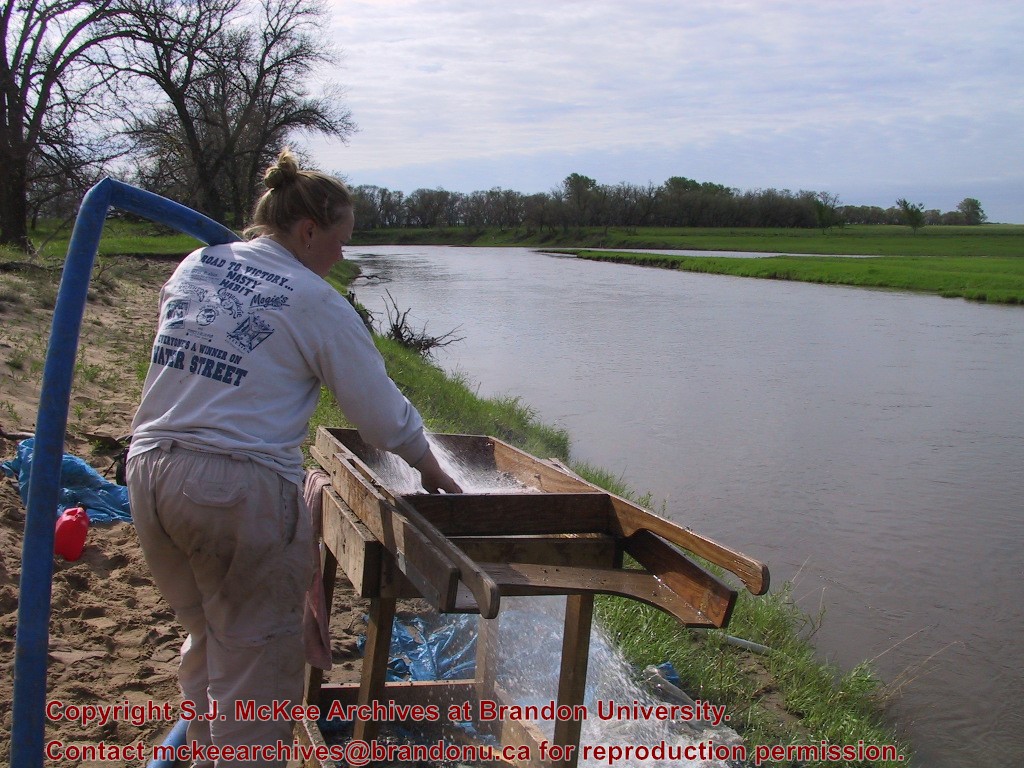
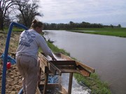
The methodology for this survey used an arbitrary datum and a transit to establish a grid of 30 m intervals and a shovel test every 20 m. Materials were removed and screened to a minimum depth of 50 cm below surface. All recovered materials were bagged and removed to the lab for further analysis. All information including: test pit grid co-ordinates; UTM co-ordinates for each test pit; artifact presence; excavator; vegetation; aspect; paleosol; paleosol depth; and notes, were entered into a GIS database.
Approximately 600 shovel test pits were excavated and recorded in this fashion. Of the 600 shovel test pits, over 300 contained cultural materials. Based on the results of the Casselman survey several areas were designed for further testing and excavation. Crepeele West and Crepeele East were renamed the Sarah site DiMe-28) and Crepeele 3 which became the Crepeele site DiMe- 29.
Scope and Content
Sub-sub-sub series contains: Summary information of field methology, number and co-ordinates of excavations, personnel and their staff position; Field journalsare daily records of recoveries, features and activities at the site; Site records include excavation level and unit summaries, feature sheets, profiles; sample records and maps; Artifact catalogues are lists and identifications of all artifacts recovered; Photographs are of excavation units, features, the landscape and personnel.
Field journals have been scanned in multi-page PDF files. Artifact catalogues are PDF files in spreadsheet format. Photographs are in jpeg format.
History / Biographical
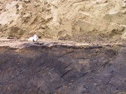
In 2004 Tomasin Playford and her crew of Andrea Richards, Sarah Graham and Shane Kolesar cleared sand cover from over the 2003 excavations and extended sand clearing back from the north edge of the 2003 units to permit implementation of four additional units. During this sand clearing a hearth was identified together with small numbers of lithics and pottery body sherds. This occupation had been noted during sand clearing in 2003 and a charcoal sample was collected and radiocarbon dated to 1440 A.D. This hearth was assigned to Atkinson II, a later occupation.
Four units (5, 6, 7, & 8) were surveyed in adjacent to the 2003 units. Excavation proceeded by means of shovel shaving until the datum pegs from the previous year were located. The new units were then given datum pegs and string boundaries and the high pressure pump was set up for water screening of silt/clay matrix.
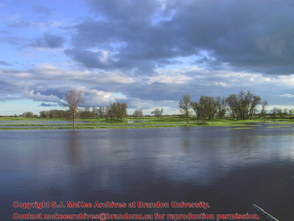
Continued to shovel shave levels 1 - 4 and recovered small burned and unburned bone fragments. Level 5 produced a projectile point, an end scraper and a large heat-treated Swan River Chert (SRC) flake. Other SRC flakes were also recovered. Levels 6 and 7 yielded large numbers of flake debitage. The matrix in levels 5-7 contained a scatter of small, bright red ochre particles. The river began to rise on the ninth of June and the site was sandbagged on June 11th, temporarily bringing an end to excavation for Atkinson 1. Tomasin and her crew were relocated to the Crepeele site, west of Lauder.
On July 20th, Tomasin and her crew returned to the Atkinson site and commenced cleaning up the earlier excavation following the flooding. Following the clean up, excavations were resumed on the units that had been opened. An additional Gowen point was recovered from level 8 as well as some poorly preserved bison bone. A lot flakes and small amounts of bone were recovered on west side of block and larger bone and flakes in bone bed along the east side in levels 8 - 10. Two bifaces were recovered in level 11 and a third in level 13. The excavations were terminated at level 18 when water started coming up through the unit floors.
Scope and Content
Sub-sub-sub series contains: Summary information of field methology, number and co-ordinates of excavations, personnel and their staff position; Field journals are daily records of recoveries, features and activities at the site; Site records include excavation level and unit summaries, feature sheets, profiles; sample records and maps; Artifact catalogues are lists and identifications of all artifacts recovered; Photographs are of excavation units, features, the landscape and personnel.
Field journals have been scanned in multi-page PDF files. Artifact catalogues are PDF files in spreadsheet format. Photographs are in jpeg format.
History / Biographical
The Crepeele site was identified from the results of the Casselman survey and excavated in 2003. Further units 1 to 8 were excavated in 2004. Funding was through the SCAPE project, directed by Dr. Bev Nicholson. The site was excavated by Crew Chief Tomasin Playford and crew.
Scope and Content
Sub-sub-sub series contains: Summary information of field methology, number and co-ordinates of excavations, personnel and their staff position.
Field journals have been scanned in multi-page PDF files. Artifact catalogues are PDF files in spreadsheet format. Photographs are in jpeg format.
History / Biographical
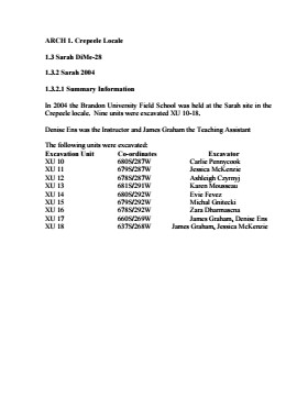
The Sarah site was initially chosen for excavation based on the results of the Casselman survey. The survey recovered significant amounts of faunal remains, some ceramics and lithics from the test pits. Excavations took place in 2003 at the Sarah site DiMe-28.
In 2004 further excavation took place as part of a Brandon University Archaeology Field School. Units 10 to 18 were excavated with Denise Ens as the instructor and James Graham teaching assistant.
Scope and Content
Sub-sub-sub series contains: Summary information of field methology, number and co-ordinates of excavations, personnel and their staff position.
Field journals have been scanned in multi-page PDF files. Artifact catalogues are PDF files in spreadsheet format. Photographs are in jpeg format.
History / Biographical
The Graham site was initially designated as a separate site early in the testing of the Crepeele locale due to what appeared to be a distinction between Early and Late Woodland ceramics. Subsequent testing has shown that this distinction was premature and that the cultural mosaic represented in the western section of the Crepeele locale does not readily separate in this manner.
Scope and Content
Sub-sub-sub series contains: Summary information of field methology, number and co-ordinates of excavations, personnel and their staff position.


