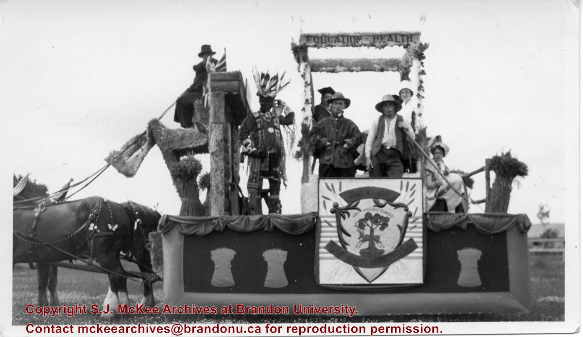
Photograph shows the City of Brandon parade float pulled by two clydesdale horses. The parade is in honour of the diamond anniversary of Canada's Confederation. The float is decorated with wheat sheaves, the city's coat of arms, and the words "education" and "health" adorn a pergola or arbour in the centre of the float. Seven people are on the float and appear to be in costume. An Aboriginal man is dressed in full regalia, one man appears to be in academic robes, another dressed as a farmer. One woman appears to be dressed like a nurse while another may be wearing a pioneer costume.
Notes
Writing on the back of the photograph reads: Brandon City's foat in 1927, Celebrating 60 years of Confederation, The lady in white is Miss Ann Carnahan who was on the city staff for a number of years and now resides in Victoria. She is my husbands [sic.] sister.
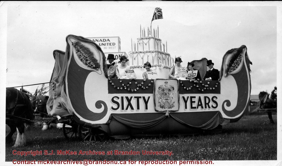
Photograph shows the Mental Hospital parade float pulled by two clydesdale horses. The parade is in honour of the diamond anniversary of Canada's Confederation. The side of the float is decorated with Canada's coat of arms and the words "Sixty Years." In the centre of the float is a three-tiered birthday cake with a Union Jack affixed to its top. Four women are draped in toga-like gowns and each are holding provincial (small) coat of arms for New Brunswick, British Columbia, Nova Scotia, and Ontario. Two men can be seen wearing top hats and coats.
Notes
Writing on the back of the photograph reads: Mental Hospital foat in 1927.
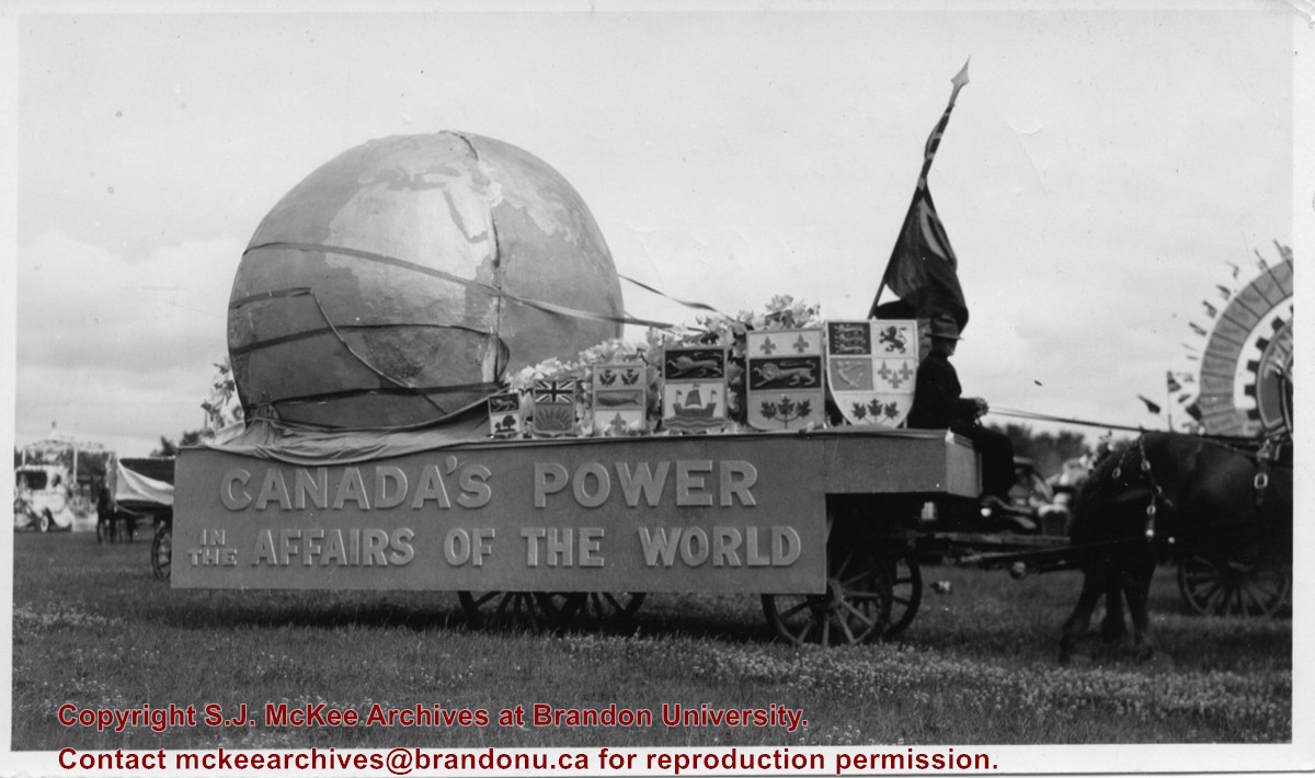
Photograph shows the Timothy Eaton Company's parade float pulled by two clydesdale horses. The parade is in honour of the diamond anniversary of Canada's Confederation. The side of the float reads: Canada's Power in the Affairs of the World. A large globe is strapped to the back of the float and the provincial coat of arms for Prince Edward Island, British Columbia, Nova Scotia, New Brunswick, Quebec, and the Dominion of Canada line the side. The Canadian Red Ensign is mounted at the front of the float.
Notes
Writing on the back of the photograph reads: T. Eaton Co. float, 1927, 60th Anniversary of, Confederation.
Photographs have been glued to a backing board that has warped over time
Scope and Content
Photograph shows street view of north side of Rosser Avenue, primarily the 700 block. Horse and buggies are travelling on the avenue and pedestrians fill the sidewalks. Union Jacks and English flags are mounted from the windows on the Fleming and Beaubier blocks. Flag banners are drapped across Rosser Avenue. Businesses visible in the Fleming Block include: Lowes Brothers Clothing and Spring Park Nurseries. Businesses visible in the Beaubier Block include the Empire Hotel. Businesses east of the Empire Hotel are grocer A.M. Percival and the Brandon Hardware Company. An advertisement for the Northern Bank is affixed to a telephone pole on the southside of the street. The street is lined with litter and a number of dogs can be seen roaming the area.
Notes
Writing on the front of the photograph matting reads: 313 July 1906. One photograph (20-2009.8) is glued below and another, 20-2009.6, is glued on the reverse side. Page appears to be from a photo album.
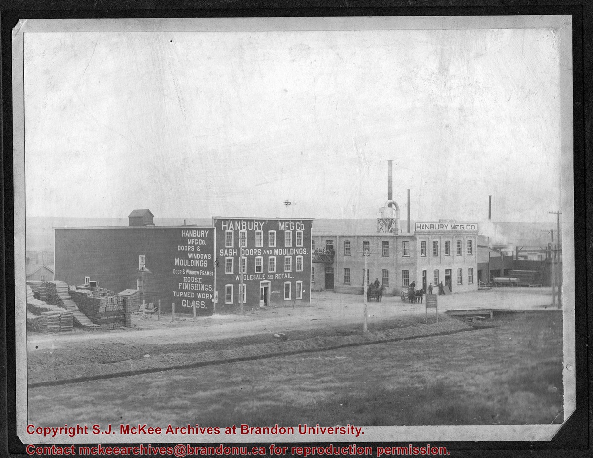
John Hanbury came to Brandon in January 1882. For the next decade he operated a contracting business, constructing several Brandon buildings including the post office, the Merchants Block, and the General Hospital. In 1892, Hanbury founded the Hanbury Manufacturing Company. The most important industry in Brandon from 1900-1914, Hanbury’s employed over 150 men in logging, lumbering and the manufacturing of doors, windows, furniture and other house fixtures.
With offices, a warehouse and lumber mill on either side of Assiniboine Avenue at 6th Street North, Hanbury’s relied on timber from northern forests that was moved, raft-like, down river by drivers. Cabinets, furniture and other millwork was sold out of the Hanbury Hardware Co. building on 7th Street and Pacific Avenue. John Hanbury left Brandon in 1910, although his son continued to operate the business until World War I.
Residential buildings were constructed on the company lands on Assiniboine Avenue west of 6th Street North in the late 1920s; the building east of 6th Street was used first as the Christie’s School Supplies warehouse (1929-1939) and then by successive woollen mills (1941-1991). A portion of what appears to be the original building currently stands vacant on the site. The hardware building on Pacific Avenue has been primarily used by the Government Liquor Control Commission (1929-1971) and Christie’s School Supplies, now Christie’s Office Plus (early 1940s – present).
Custodial History
Photos belonged to Jim Lanigan's family. He donated them to the McKee Archives in January 2017.
Scope and Content
Item is a photograph of the Hanbury Mfg Co. buildings on Assinboine Avenue - photo is looking northeast
Notes
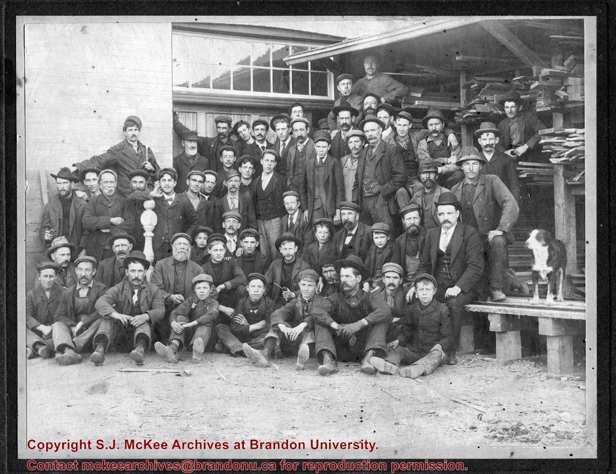
Jim Lanigan and his siblings beleived that Hanbury Manufacturing Company is where their paternal grandfather James Joseph Lanigan worked and learned the glazing trade. James Joseph's father James and brother Albert Daniel may have also worked there. Both Joe and Bert went to work for the CPR in Brandon in 1898. Jim Lanigan could not identify any family members in the group portrait.
John Hanbury came to Brandon in January 1882. For the next decade he operated a contracting business, constructing several Brandon buildings including the post office, the Merchants Block, and the General Hospital. In 1892, Hanbury founded the Hanbury Manufacturing Company. The most important industry in Brandon from 1900-1914, Hanbury’s employed over 150 men in logging, lumbering and the manufacturing of doors, windows, furniture and other house fixtures.
With offices, a warehouse and lumber mill on either side of Assiniboine Avenue at 6th Street North, Hanbury’s relied on timber from northern forests that was moved, raft-like, down river by drivers. Cabinets, furniture and other millwork was sold out of the Hanbury Hardware Co. building on 7th Street and Pacific Avenue. John Hanbury left Brandon in 1910, although his son continued to operate the business until World War I.
Residential buildings were constructed on the company lands on Assiniboine Avenue west of 6th Street North in the late 1920s; the building east of 6th Street was used first as the Christie’s School Supplies warehouse (1929-1939) and then by successive woollen mills (1941-1991). A portion of what appears to be the original building currently stands vacant on the site. The hardware building on Pacific Avenue has been primarily used by the Government Liquor Control Commission (1929-1971) and Christie’s School Supplies, now Christie’s Office Plus (early 1940s – present).
Custodial History
Photos belonged to Jim Lanigan's family. He donated them to the McKee Archives in January 2017.
Scope and Content
Item is a group portrait of Hanbury Manufacturing Company employees.
Notes
Jim Lanigan and his siblings beleived that Hanbury Manufacturing Company is where their paternal grandfather James Joseph Lanigan worked and learned the glazing trade. James Joseph's father James and brother Albert Daniel may have also worked there. Both Joe and Bert went to work for the CPR in Brandon in 1898. Jim Lanigan could not identify any family members in the group portrait.
Photograph shows the 800 block of Rosser Avenue facing west. On the south side of Rosser Avenue the Nation Block, Christie's Bookstore, and Reesor's Clock can be seen. A number of horse and buggies/carriages are travelling along Rosser Avenue.
Photograph has been glued to a backing board that has warped over time
History / Biographical
On 16 November 1906, Manitoba was hit by a severe winter storm that began that Thursday evening and extended through the weekend. The Brandon Daily Sun ("Storm Extends Over a Large Territory," 17 Nov. 1906, 1) reported that rail and telegraph services had been disrupted, country roads were impassable, and business in town was at a stand still. Following the weekend, the daily reported the blizzard was one of the greatest in recent memory. CPR trains had been caught in drifts by Carberry and an express car had caught fire and was destroyed ("Worst Storm in Many Years," Brandon Daily Sun, 19 Nov. 1906, 1).
Scope and Content
Photograph shows street view of intersection of the 000 block of 8th Street and Rosser Avenue in the winter. Businesses on the east side of 8th Street from Pacific to Rosser Avenues are clearly visible and include: a Lunch Room (likely Aagaard's Lunch Counter), the Hotel Imperial Annex, Liverpool House (a boarding house), R.S. Thompson and Company Real Estate Office (Land Office), a barber shop (likely J. Coulter's), Frank Gowen photography studio. Fleming's Drug Store on the corner of 8th Street and Rosser Avenue has been replaced by the Bank of Hamilton. The Imperial Hotel is visible on the west side of 8th Street. The 8th Street Bridge is visible in the background. Men in winter coats and hats are crossing the street at the intersection. A horse-drawn sleigh is parked on 8th Street.
Notes
Writing on the front of the photograph matting reads: 340, after the storm November 1906. Page appears to be from a photo album. The photograph appears to be taken from the interior of a builing on the southwest corner of 8th Street and Rosser Avenue.
Photographs have been glued to a backing board that has warped over time
History / Biographical
Photograph of possible Dakota from Sioux Valley in Brandon for the summer fair.
Scope and Content
Photograph shows street view of north side of Rosser Avenue, primarily the 700 block. Businesses visible in the Fleming Block include: Lowes Brothers Clothing, Robert Hall [Insurance Broker], Manitoba Farmers Hedge and Wire Fence Company. Businesses visible in the Beaubier Block include the Empire Hotel. Businesses east of the Empire Hotel are grocer A.M. Percival and the Brandon Hardware Company. A number of Aboriginal peoples are travelling on horseback west along Rosser Avenue as spectators look on.
Notes
Writing on the front of the photograph matting reads: 293. One photograph (20-2009.9) is glued above and two others are glued on the reverse side. Page appears to be from a photo album.
Photographs have been glued to a backing board that has warped over time
History / Biographical
Photograph of possible Dakota from Sioux Valley in Brandon for the summer fair.
Scope and Content
Photograph shows street view of north side of Rosser Avenue, primarily the 700 block. Businesses visible in the Beaubier Block include the Empire Hotel. Businesses east of the Empire Hotel are grocer A.M. Percival, the Brandon Hardware Company, and the Arlington Hotel. A number of Aboriginal peoples are driving horse and buggies east along Rosser Avenue as large numbers of spectators look on.
Notes
Writing on the front of the photograph matting reads: 298. One photograph (20-2009.79) is glued above, another (20-2009.81) adjacent. One other is glued on the reverse side. Page appears to be from a photo album.
Photographs have been glued to a backing board that has warped over time
History / Biographical
Photograph of possible Dakota from Sioux Valley in Brandon for the summer fair.
Scope and Content
Photograph shows street view of north side of Rosser Avenue, primarily the 700 block. Businesses visible in the Fleming Block include: Lowes Brothers Clothing, Robert Hall [Insurance Broker], Manitoba Farmers Hedge and Wire Fence Company. Businesses visible in the Beaubier Block include the Empire Hotel. Businesses east of the Empire Hotel are grocer A.M. Percival and the Brandon Hardware Company. A number of Aboriginal peoples are driving horse and carriages west along Rosser Avenue as spectators look on.
Notes
Writing on the front of the photograph matting reads: 295 July 1906. One photograph (20-2009.11) is glued above and two others are glued on the reverse side. Page appears to be from a photo album.
Photographs have been glued to a backing board that has warped over time
Scope and Content
Photograph shows street view of north side of Rosser Avenue, primarily the 700 block. The Fleming Block, Beaubier Block and its Empire Hotel, A.M. Percival (a grocer), the Brandon Hardware Company (600 block), and the Arlington Hotel (500 block) are visible along the north side of the avenue. The Bank of Hamilton Building on the southeast corner of 8th Street and Rosser appears to be under construction. A sign in the second storey window above the main entrance reads: law office. The streets are muddy and a horse and buggy is traveling west on Rosser Avenue.
Notes
Writing on the front of the photograph matting reads: mud November 12, 1906, 339. The photograph appears to be taken from the interior of a builing on the southwest corner of 8th Street and Rosser Avenue. Page appears to be from a photo album.
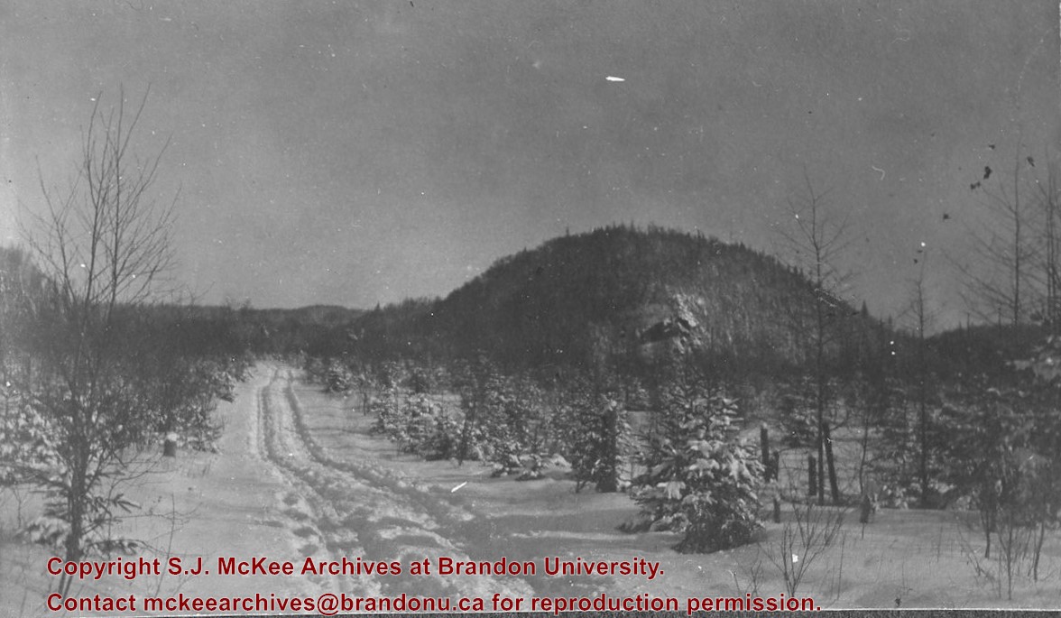
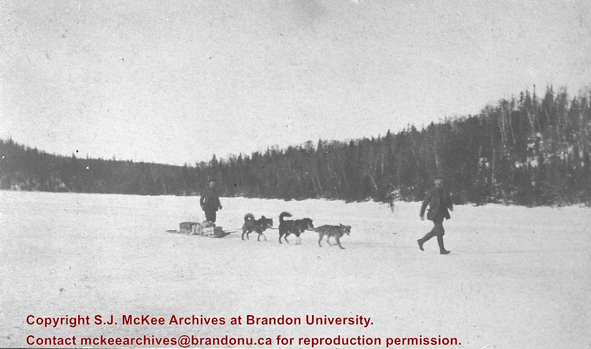
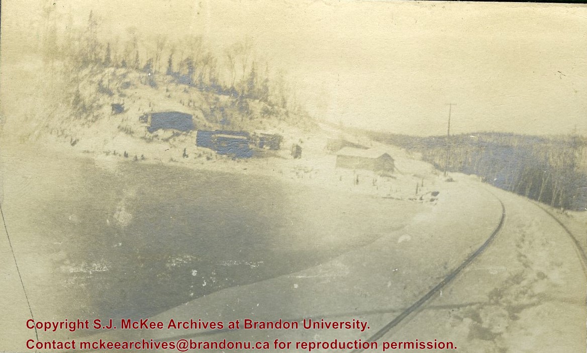
Brient was a point along the Algoma Central Railway line that connected the Helen Mine to the Michipicoten Harbour. It is located southwest of Wawa, Ontario.
Scope and Content
Photograph shows ore box cars in a railway yard.
Notes
Writing beneath the photograph in the album reads: yard at Brient
According to the Brandon Daily Sun (07 May 1913), the first three street cars (Nos. 10, 9, and 7) arrived in Brandon on the evening of May 6, 1913. The cars were shipped via Canadian National Rail to Brandon from Winnipeg and stored at the railway siding on McTavish Avenue between 8th and 9th Streets. The daily paper (15 May 1915) reported that a test run for the street cars was scheduled for May 16, 1913. The City Clerk published a public notice in the paper (29 May 1913) announcing the formal opening of the "Brandon Municipal Street Raily" for on Monday, June 2, from 2 p.m. to 4 p.m. at city hall where the cars would be displayed.
Custodial History
Donated to Fred McGuinness by Allena Strath (nee Coombs).
Scope and Content
Postcard depicts three municipal street cars parked on the 10th Street tracks in front of the Winter Fair Building. In front of the cars are a group of men wearing suits, hats, and top coats. Two automobiles are parked alongside the street cars. According to Archivist Emeritus Tom Mitchell, the group of men are members of the Brandon Municipal Street Railway Committee. The chairman of the committee, Harry Cater, can be seen in the center-left of the group wearing a watch fob. The committee had assembled for a test run of the street car service, which the Brandon Daily Sun reported to have occured on Sunday, May 16, 1913.
Notes
Back of postcard reads: First Street Car in Brandon in front of Winter Fair building 1910.
Photograph shows the Brandon Wheat Market along Pacific Avenue on November 30, 1885. Farmers can be seen driving wagon teams loaded with bags of grain in line on Pacific Avenue from 10 Street to at least 7th Street. On the north side of Pacific Avenue the CPR Land Office and grain elevators are pictured. On the south side of Pacific Avenue, the general merchant/hardware store Bower, Blackburn, Mundell & Porter is situated on the corner of Pacific Avenue and 10th Street. A 10th Street sign is affixed to the merchants' store. On the east side of the general store, Edie House, the Grand View Hotel, and a Farmers' boarding and lodging house can be seen. Most of the buildings appear to be woodframed except for the Grand View, which is constructed of brick. Sidewalks appear to be in place on the south side of Pacific and snow dusts the streets. A baby swathed in winter clothing sits in a pram/baby carriage in front of the general store.
Notes
Writing on the front of the photograph reads: Novemeber 30th, 1885, Brandon Wheat Market
Photographs have been glued to a backing board that has warped over time
History / Biographical
Photograph of possible Dakota from Sioux Valley in Brandon for the summer fair.
Scope and Content
Photograph shows street view of north side of Rosser Avenue, primarily the 700 block. Businesses visible in the Fleming Block include: Lowes Brothers Clothing, Robert Hall [Insurance Broker], Manitoba Farmers Hedge and Wire Fence Company. Businesses visible in the Beaubier Block include the Empire Hotel. Businesses east of the Empire Hotel are grocer A.M. Percival and the Brandon Hardware Company. A number of Aboriginal peoples are driving horse and buggies west along Rosser Avenue as spectators look on.
Notes
Writing on the front of the photograph matting reads: 294 July 1906. One photograph (20-2009.10) is glued below and two others are glued on the reverse side. Page appears to be from a photo album.


