Saskatchewan's Fourth Meridian (meridian 110 degrees west of Greenwich) forms the western boundary of the province and is part of the world's longest surveyed straight line.
Scope and Content
Photograph shows two RCMP members in red serge standing next to a monument covered in the Union Jack flag.
Notes
A negative exists for this photo and is stored with the picture.
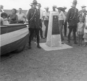
Saskatchewan's Fourth Meridian (meridian 110 degrees west of Greenwich) forms the western boundary of the province and is part of the world's longest surveyed straight line.
Scope and Content
Photograph shows two RCMP members in red serge standing next to a monument dedicated/marking the Fourth Meridian.
Notes
A negative exists for this photo and is stored with the picture.
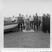
Saskatchewan's Fourth Meridian (meridian 110 degrees west of Greenwich) forms the western boundary of the province and is part of the world's longest surveyed straight line.
Scope and Content
Photograph shows the platform party at the dedication of the Fourth Meridian monument.
Saskatchewan's Fourth Meridian (meridian 110 degrees west of Greenwich) forms the western boundary of the province and is part of the world's longest surveyed straight line.
Scope and Content
Photograph shows the platform party at the dedication of the Fourth Meridian monument.
Saskatchewan's Fourth Meridian (meridian 110 degrees west of Greenwich) forms the western boundary of the province and is part of the world's longest surveyed straight line.
Scope and Content
Photograph shows the platform party at the dedication of the Fourth Meridian monument.
Photograph was taken by Christy Henry on August 10, 2002 following the grand opening of the Labyrinth of Peace. The Labyrinth is situated in the Assiniboine River Corridor near the Discovery Centre in Brandon, Manitoba.
Custodial History
See series level of the Christy Henry fonds for Custodial History.
Scope and Content
Photograph shows the centre symbol - a wheat sheaf carved into a piece of stone shaped like the province of Manitoba - of the Labyrinth of Peace.
Storage Location
RG 5 photograph storage drawer
32-2007
Related Material
Additional information on the history of the Labyrinth of Peace project can be found in RG 6 (Brandon University fonds) 7.1.6 (Department of Religion) File 1.
Photograph was taken by Christy Henry on August 10, 2002 following the grand opening of the Labyrinth of Peace. The Labyrinth is situated in the Assiniboine River Corridor near the Discovery Centre in Brandon, Manitoba.
Custodial History
See series level of the Christy Henry fonds for Custodial History.
Scope and Content
Photograph shows the information board for the Labyrinth of Peace.
Storage Location
RG 5 photograph storage drawer
32-2007
Related Material
Additional information on the history of the Labyrinth of Peace project can be found in RG 6 (Brandon University fonds) 7.1.6 (Department of Religion) File 1.
For custodial history see the collection level description of the Lawrence Stuckey collection.
Scope and Content
Stanley Park from old PC.
Notes
Shows bandstand
[By "PC" Mr. Stuckey likely meant to indicate Park School (built 1904, demolished 1978). Park School was, at the time the photo was taken, located directly across Lorne Avenue from Stanley Park. P.E. 22/07/09]
This wedge-shaped tract of woodland was located west of 34th Street on the south side of the Canadian Pacific Railway. It was formerly owned by the Great Northern Railway, and was acquired by the CPR when the GN line was abandoned in 1936. In 1978 Marathon Realty (CPR) sold this 7 acre property to a developer who planned to build condominiums. However this residential development was objected to for two reasons: [The proposed location] was home to many species of flora & fauna, and it was too close to the CPR mainline. Local residents took out a petition against the development. [Mr. Stuckey] wrote a letter to the editor of the Brandon Sun, [expressing the] attitudes of CPR officials, and read a statement to the Provincial Planning Board suggesting development be refused and the area become an undeveloped park. These efforts would prove successful - see file on same.
Custodial History
For custodial history see the collection level description of the Lawrence Stuckey collection.
Scope and Content
John Indian's Bush (also known as Bang's Bush)
Notes
Additional historical information provided by the Fred McGuinness collection (20-2009). Stuckey's letter to the editor appears in the July 22, 1978 issue of The Brandon Sun.
This wedge-shaped tract of woodland was located west of 34th Street on the south side of the Canadian Pacific Railway. It was formerly owned by the Great Northern Railway, and was acquired by the CPR when the GN line was abandoned in 1936. In 1978 Marathon Realty (CPR) sold this 7 acre property to a developer who planned to build condominiums. However this residential development was objected to for two reasons: [The proposed location] was home to many species of flora & fauna, and it was too close to the CPR mainline. Local residents took out a petition against the development. [Mr. Stuckey] wrote a letter to the editor of the Brandon Sun, [expressed the] attitudes of CPR officials, and read a statement to the provincial planning board suggesting development be refused and the area become an undeveloped park. These efforts would prove successful - see file on same.
Custodial History
For custodial history see the collection level description of the Lawrence Stuckey collection.
Scope and Content
John Indian's Bush (also known as Bang's Bush).
Notes
Additional historical information provided by the Fred McGuinness collection (20-2009). Stuckey's letter to the editor appears in the July 22, 1978 issue of The Brandon Sun.
Peace Garden. Student activity: International Relations Conference. study group L-R Mellanie Berthume (?), Marion McGregor (?), ?, Dave Halstead, ?, Nora Malyn (centre at head of the table)
faculty activity (science) - opening of the observatory-women's auxiliary presenting cheque. L to R-Helen, Wes Wong, Don Mackay, ?, Lloyd Dulmage, Wesley Wong
Opening of the observatory-receiving of donation from women's auxiliary. L to R Back- D. R. MacKay, ?, Wes Wong, Gwen (Mrs. D. R.) MacKay, Lloyd Dulmage; Front-Helen Wong, Mrs. J. Hardy, Bernice (Mrs. Lloyd) Dulmage, Billie (Mrs. Gordon) McPherson, Charlotte (Mrs. Cliff) Carbano
Faculty activity (science) opening of the Observatory. L to R- D. R. Mackay, Helen Wong, Bernice Dulmage, Charlotte Carbano, Billie McPherson ?, Hardy, ?, Gwen MacKay, ?, Wesley Wong; Foreground-Lloyd Dulmage
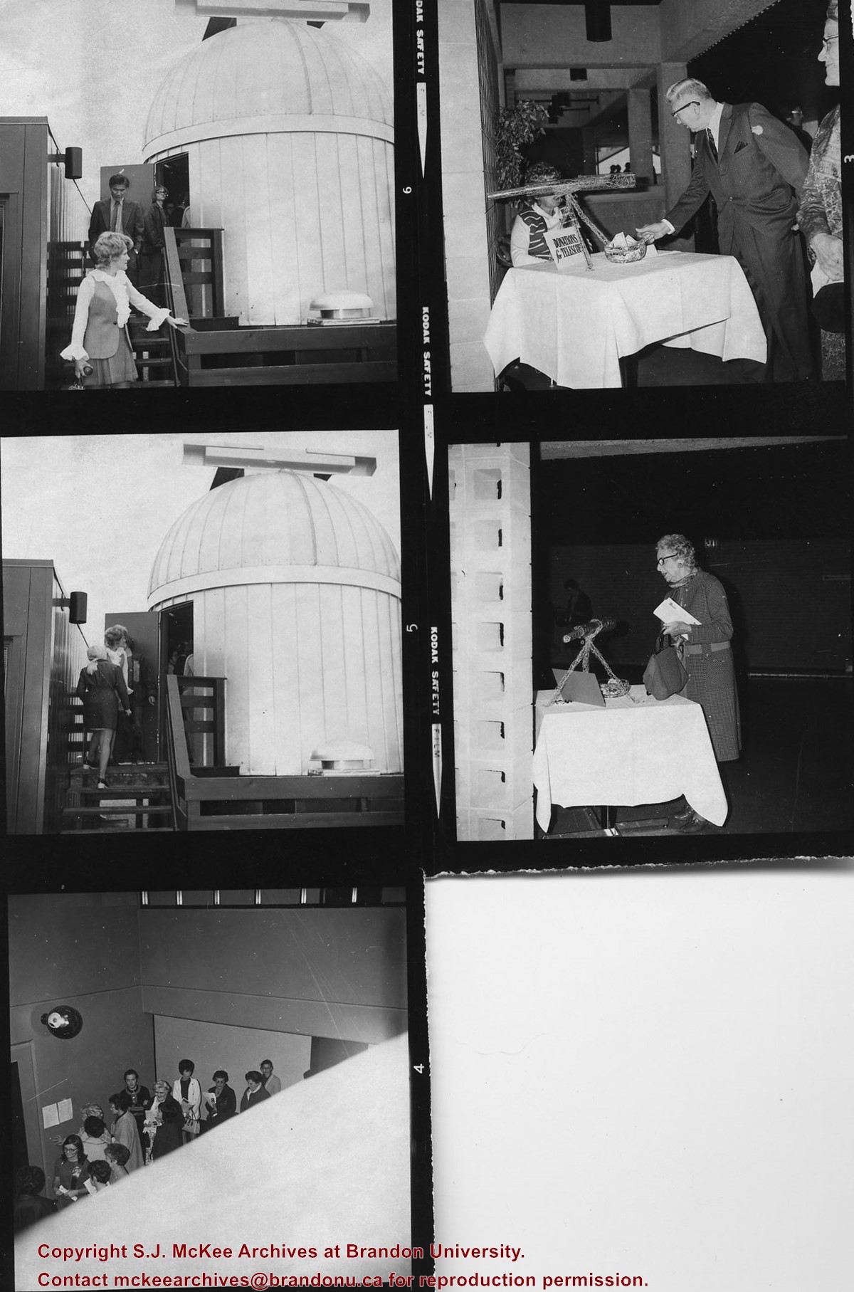
The Observatory is located on the roof of McMaster Hall.
Scope and Content
Item is five contact prints taken at the opening of the Observatory.
Print 1: Steps to the Observatory (man on the steps is Westly Wong)
Print 2: Steps to the Observatory
Print 3: Visitors
Print 4: Foyer of McMaster Hall (Prof. R.M. Simmons making a donation towards a telescope)
Print 5: Foyer of McMaster Hall (female visitor)


.jpg?width=1200&404=no-img.jpg&watermark=wmk)
.jpg?width=180&404=no-img.jpg)
.jpg?width=1200&404=no-img.jpg&watermark=wmk)
.jpg?width=180&404=no-img.jpg)


.jpg%3fmaxheight%3d1000%26maxwidth%3d1000%26watermark%3dwmk&description=John+Indian%27s+Bush)
.jpg%3fmaxheight%3d1000%26maxwidth%3d1000%26watermark%3dwmk&description=John+Indian%27s+Bush)