ARCH 2: North Lauder Locale
The North Lauder locale has a long archaeological and geological history that is important for understanding the forces that shaped the region. Archaeological research in the locale shows that the area has been occupied by humans for at least the past 6,500 years. Environmental forces provided an area of diverse resources that attracted early peoples.
Environment of the Lauder Sandhills
The North Lauder locale is part of the greater Lauder Sandhills area. The glaciers that covered this region began to recede approximately 11,000 years ago leaving a large lake known as glacial Lake Hind. The Souris River, the Lauder Sandhills and the Oak Lake Aquifer are remnants of the environmental and geological forces that shaped the region.
The Lauder Sandhills region is characterized by a landscape of sand sheets and stabilized sand dunes interspersed with a variety of wetlands. This complex topographic and hydrological situation favoured the development of an island mosaic of mixed forest, wetland and meadow, surrounded by mixed grass prairie. The result was a large, isolated ecotone which provided a rich variety of subsistence resources for hunter-gatherers.
Research in the Lauder Sandhills
Archaeologists from Brandon University have been conducting research in the Lauder Sandhills since 1991. Research in the North Lauder locale has focused on the Atkinson site, a 6,500 year old hunter-gatherer site and Flintstone Hill.
The Atkinson site
The Atkinson site is one of the oldest excavated sites in Manitoba and has been Radiocarbon dated to 6,500 years before present. The Atkinson site is located on the bank of the Souris River and was discovered when a hearth (fire pit) was seen eroding out of the bank. Based on the date of the site and the kind of lithics (stone tools) present it is considered a Gowen occupation. The Atkinson site is evidence that bison hunters were active on the northern plains at a very early date. Similar sites have also been found on the High Plains in the U.S. and are referred to as the Mummy Cave Complex.
The Atkinson Site is of great importance as it is the first undisturbed site of this type to be excavated in Manitoba and extends the range of these sites south and east from the type-sites in central Saskatchewan.
Flintstone Hill
The geomorphology of the glacial Lake Hind Basin over the past 11,000 years is known primarily through the study of a cut bank along the Souris River. Flint Stone Hill contains the most complete stratigraphic record for the post-glacial period on the northern plains. The site has been extensively studied by geoarchaeologists, geologists and paleoenvironmentalists over many years and their findings have contributed to our understanding of the region.
The North Lauder locale Borden designations of Atkinson site DiMe-27 and Flintstone Hill site DiMe-26.
Borden System
Archaeological sites in Canada are identified by the Borden system, which is a uniform site designation system. The country is divided into grids based on latitude and longitude in blocks of 10 x 20 minutes. The first 4 letters indicate the block and the following numbers indicate the actual site. For example the area of the Lauder Sandhills in southwestern Manitoba is identified by the letters DM and the North Lauder locale within that area is DiMe. The Atkinson site is DiMe-27 and the Flintstone Hill site DiMe-26. As new sites are discovered they will be numbered sequentially.
Scope and Content
The Series has been divided into two sub-series, including (1) Atkinson site DiMe-27 and Flintstone Hill site DiMe-26.
The Atkinson site was named for the landowners Ken and Karen Atkinson who were very helpful to the archaeology and geoarchaeology crews that worked at the site. Their support made the project possible.
The Atkinson site story begins with the discovery of a charcoal lens eroding from the north bank of the Souris River in the summer of 2002. Study of Cultural Adaptations on the Prairie Ecozone (SCAPE) project geoarchaeologist Dr. Garry Running was exploring the stratigraphic layering in the bank when he noted the lens and reported it to Dr. Bev Nicholson. Upon closer examination, a tiny pressure flake was observed on the lens exposure and it was decided to collect a charcoal sample for radiocarbon dating.
The resulting date of 5250B.P cal. 4225 B.C. placed the site in the early Archaic period. A second date on bone collagen of 5580B.P. cal. 4500 B.C. confirmed the earlier date and gave an averaged date of circa 4400 B.C or 6,500 years ago.
The Atkinson site is one of the oldest excavated sites in Manitoba. Based on the date of the site and the kind of lithics (stone tools) present it is considered a Gowen occupation. The Atkinson site is evidence that bison hunters were active on the northern plains at a very early date. Similar sites have also been found on the High Plains in the U.S. and are referred to as the Mummy Cave Complex.
The Atkinson Site is of great importance as it is the first undisturbed site of this type to be excavated in Manitoba and extends the range of these sites south and east from the type-sites in central Saskatchewan. Based on the date and sample evidence further excavations were conducted by Dr. Nicholson's team. in 2003, 2004 and 2006.
Scope and Content
Sub series has been divided into three sub sub series including: (1) Atkinson 2003, (2) Atkinson 2004; (3) Atkinson 2006
Block B consisted of 20 contiguous 1m2 units excavated to 30 cm below surface. (except unit 58 which was excavated to 35 cm bs to obtain extended soil profile). The block is situated in recent oak and poplar forest at the head of a ravine leading to Jock’s Creek, adjacent to an area cleared for market gardening. As was the case with Block A, the understory is heavily overgrown with hazelnut, chokecherry, saskatoon, and a poison ivy/sarsaparilla ground cover.
The soil levels below the sod in Block B consisted of a black, silty, and gritty loam layer from 5 cm to 23 cm below surface, a yellow and sandy clay from 23 cm to 30 cm below surface, and glacial till at 30 cm below surface. As in Block A, limestone cobbles were found throughout the occupation level around the bone. It is evident that bioturbation – primarily tree roots and rodent burrowing – have significantly altered patterns of original deposition of lithics, ceramics and small bone.
The faunal layer lay close to the surface, situated entirely in the black loam 5 cm – 23 cm below surface. The 23 cm depth also marked the end of the dark silty loam. At 10 cm below surface, a discernible patterning of the bone appeared. Concentrations of bone in narrow rows ran in an irregular pattern from the northwest to the southeast part of the block. This pattern was most apparent in the north end of the block which is the highest point in the block. In the same 1m2 unit, patches of weathered, very poorly preserved bone would be found lying close to patches of well preserved bone. It is believed that this variability in preservation results from uneven rates of burial due to taphic activities of pocket gophers or other agents of bioturbation. The same pattern of uneven preservation occurs over much of the locale but is most evident in Block B.
Diagnostic lithics included eleven projectile points that were predominantly Plains or Prairie Side-notch types, but included two unnotched triangular points. Cord-wrapped impressed rim sherds and body sherds were recovered. The ceramics are variants of the Woodland Blackduck horizon.
RC dates: XU49 – 675/80 BP XU 59 – 705/75BP.
Scope and Content
Sub-sub-sub series contains: Summary information of field methology, number and co-ordinates of excavations, personnel and their staff position; Field journals are daily records of recoveries, features and activities at the site; Site records include excavation level and unit summaries, feature sheets, profiles; sample records and maps; Artifact catalogues are lists and identifications of all artifacts recovered; Photographs are of excavation units, features, the landscape and personnel.
Block C was situated in sparse oak forest with an understory of saskatoon, hazelnut and a thick ground cover of poison ivy and sarsaparilla. The block measured 3m and 3m and contained nine excavation units. All units were excavated to 35cm below surface. The soil horizons were much like the other blocks, except for a rusty brown stain in the first level, giving the upper black loam a mottled appearance. The brown patches were clay mixed with loam and were harder than the surrounding matrix. No definitive interpretation of these phenomena was attempted but this effect may be the result of natural brush or forest fires. Under the 5cm so d/humus (Ah) layer, the loam horizon extended approximately 5cm – 25 cm below surface, and averaged 20 cm thick. Bone was concentrated within this horizon between 10 cm – 20 cm below surface.
Block C was notable for its concentrations of articulated bison bone. Most noteworthy was an articulated unit composed of lumbar vertebrae, pelvis, and sacrum. Several thoracic vertebra/proximal rib end concentrations were also recovered. There were more vertebrae and rib sections recovered in the units in proportion to other bones. A few sherds, some debitage and a single Prairie Side-Notched point fragment were among the recoveries. Based on the quantity of bone, the density of the bone layer, and the articulated butchering units the area has been interpreted as a bone midden.
Faunal material was analysed by Jessica MacKenzie for her Honours Thesis: "A reconstruction of butchering processes in Block C from the Lovstrom site DjLx-1 in Southwestern Manitoba."
Radiocarbon date: 850/115BP XU 79.
Scope and Content
Sub-sub-sub series contains: Summary information of field methology, number and co-ordinates of excavations, personnel and their staff position; Field journals are daily records of recoveries, features and activities at the site; Site records include excavation level and unit summaries, feature sheets, profiles; sample records and maps; Artifact catalogues are lists and identifications of all artifacts recovered; Photographs are of excavation units, features, the landscape and personnel.
The Sarah site was chosen for excavation based on the results of the Casselman survey. The survey recovered significant amounts of faunal remains, some ceramics and lithics from the test pits. Excavations took place in 2003 at Crepeele West (Units 1-5) and Crepeele East (Units 6-9). The site was subsequently renamed the Sarah site DiMe-28. In 2004 another 9 units were excavated (Units 10-18).
Based on the recoveries it was determined that the Sarah site is a stratified site with woodland ceramics in the upper occupation and late woodland points in both of the upper occupations. These upper occupations produced abundant bison bone including foetal bone. The lower occupations produced less bone and no foetal bone, although absence of foetal bone in the lower occupations does not necessarily indicate a warm season occupation. This could be due to sample error or perthotaxic factors such as scavenging of the fragile bone by dogs or other carnivores.
The dates from the Sarah site include 550+/-40 B.P.; 1430+/-80 B.P; 2810+/-80 B.P.; 3120+/-130 B.P. The lower occupations did not yield any diagnostic materials although debitage was abundant. These occupations were most productive at the edge of the large sand dune at the southern edge of the excavations. It is assumed that the major portion of these occupations have been overridden by the dune in the past 3000 years. Heavy earthmoving equipment would be required to remove this overburden which limits the possibility of future excavation.
Environment
The Sarah site is a large area located at the eastern end of the Crepeele locale. Ground cover is a mosaic of aspen poplar groves and patches of mesic grass prairie. Excavation profiles indicate that this has been the situation since early precontact times, although as local climatic conditions change (primarily rainfall), the relative size of these areas and where they may have occurred also changed. The soil is aeolian sand sheet derived from delta outwash deposits along the western edge of glacial Lake Hind. The present topography is a variable dune landscape reworked by aeolian activity that creates a mosaic of microhabitats. These include forested patches in the lee of sand dunes with grassland on the southern and western exposures and small damp lowlands that support balsam poplar, willows, red osier dogwood, high-bush cranberry and water birch. There is no permanent water source in the area although a small seasonal stream meanders through a damp lowland to the east of the Sarah site.
Scope and Content
Sub-series has been divided into sub sub series including: Sarah 2003 and Sarah 2004,
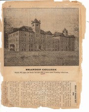
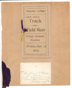
Sub-series consists of four scrapbooks detailing life at Clark Hall and Brandon College. They include newspaper clippings, photographs, cards, various programs and ephemera.
Storage Location
RG 1 Brandon College fonds
Series 9: Clark Hall Women's Residence
Item is a scrapbook created by Ernestine Whiteside during her years as Lady Principal of Clark Hall, the women's residence at Brandon College. Scrapbook contains photographs, cards, programs, newspaper clippings and ephemera that document the lives and activities of Brandon College students.
Storage Location
RG 1 Brandon College fonds
Series 9: Clark Hall Women's Residence
Item is a scrapbook begun by Ernestine Whiteside during her years as Lady Principal of Clark Hall, the women's residence at Brandon College, and continued by successive Deans of Women Olive Wilkins (1919-1925), Jane (Jennie) Turnbull (1926-1927) and Annie (Evans) Wright (1927-1934). Scrapbook contains photographs, cards, programs, newspaper clippings and ephemera that document the lives and activities of Brandon College students.
Storage Location
RG 1 Brandon College fonds
Series 9: Clark Hall Women's Residence
Item is a scrapbook begun by Annie (Evans) Wright during her years as Dean of Women at Brandon College (1927-1934) and continued by her successors D. Werthenbach (1934-1935), Marjorie McKenzie (1935-1936) and Sarah Persis Darrach (1937-1953). Scrapbook contains photographs, cards, programs, newspaper clippings and ephemera that document the lives and activities of Brandon College students.
Storage Location
RG 1 Brandon College fonds
Series 9: Clark Hall Women's Residence
Item is a scrapbook created by Sarah Persis Darrach during her years as Dean of Women at Brandon College. Scrapbook contains photographs, cards, programs, newspaper clippings and ephemera that document the lives and activities of Brandon College students.
Storage Location
RG 1 Brandon College fonds
Series 9: Clark Hall Women's Residence
The Graham site is a located adjacent to the Crepeele site towards the western end of the Crepeele locale. The Graham site was initially designated as a separate site early in the testing of the Crepeele locale due to what appeared to be a distinction between Early and Late Woodland ceramics. Subsequent testing has shown that this distinction was premature and that the cultural mosaic represented in the western section of the Crepeele locale may not readily separate in this manner. However, due to the records management that was already in place, the original separate designations have been retained.
Environment
Ground cover is a mosaic of aspen poplar groves and patches of mesic grass prairie. Excavation profiles indicate that this has been the situation since early precontact times, although as local climatic conditions change (primarily rainfall), the relative size of these areas and where they may have occurred also changed. The soil is aeolian sand sheet derived from delta outwash deposits along the western edge of glacial Lake Hind. The present topography is a variable dune landscape reworked by aeolian activity that creates a mosaic of microhabitats. These include forested patches in the lee of sand dunes grassland on the southern and western exposures and small damp lowlands that support balsam poplar, willows, red osier dogwood, high-bush cranberry and water birch. There is no permanent water source in the area although a small seasonal stream meanders through a damp lowland along the eastern margin of the Crepeele locale.
Excavations at the Graham site took place from 2004 to 2008. Analyses of the recoveries shows that, with two exceptions, all of the occupations that have been tested produced bison foetal bone. The presence of foetal bison is a strong indicator of wintering occupations...The absence of foetal in some area does not necessarily indicate warm season occupations since these excavation series are small and the absence could be due to sample error or perthotaxic factors, such as scavenging of the fragile bone by dogs or other carnivores.
From this evidence the Graham site has been interpreted as being primarily a wintering area. This is consistent with the lack of surface water (snow would serve as a substitute in winter) and the abundance of wood for fuel – a critical requirement for winter occupation. Cultural occupations date from Mortlach circa 250 B.P to woodland circa 580 B.P.
Scope and Content
Sub-series has been divided into sub sub series including: Graham 2004, Graham 2005, Graham 2006 and Graham 2008
Block D was wooded with oak and an understory of saskatoon and hazelnut with a thick ground cover of poison ivy and sarsaparilla. Root and rodent disturbance was extensive.
Based on the recoveries from Test Unit 22 during the survey, further excavations were carried out. Two units 87 and 93 were excavated in 1987. A further four units were excavated in 1988. There appears to be a pre contact occupation and a protohistoric feature within the block.
Diagnostic lithics included a chert Plains Side-notch projectile point, and a large Woodland side-notched point. The lithic materials from Block D are primarily local cherts followed in abundance by Knife River Flint and Tongue River Silicified Sediment – both of which are exotics imported from the southwest. Faunal remains were primarily bison.
Thin-walled obliterated fabric impressed pottery with grit temper was recovered in all units. Diagnostic ceramics included two rims, one with a fabric impressed exterior and the lip notched with dowel impressions, and a second thick walled rim was fabric impressed to the lip. The ceramic wares appear to be essentially a Woodland complex with overtones of Plains influence.
RC date: 230/90 BP.
Scope and Content
Sub-series has been divided into sub sub series including: Lovstrom Block D 1987 and Lovstrom Block D 1988.
This site is situated in a naturally sheltered area with a low rise to the east and south partly encircling a flat area open to the west. Present natural vegetation is an open oak forest with a light understory of saskatoon, hazelnut, poison ivy and sarsaparilla. It is situated on the till plain at the upper end of a ravine leading to Jock’s Creek.
Two test units six meters apart were excavated in 1987 and produced cultural materials which warranted a block excavation, so seven contiguous 1m2 units were then opened. These units proved to be very productive of cultural remains. Subsequent excavations in 1988 increased the number of excavated units to 21. In 1991 a further eight units were excavated for a total of 29 excavations and two test units. Excavations went deeper in this block than in Blocks C or B. Remains from the block included bison bone, bone tools, fire-cracked rock, ceramics, lithics including tools and debitage and a hearth. Another occupation was recovered in 1991 containing a hearth and living floor.
Radiocarbon samples have produced two distinct sets of radiocarbon dates from 1987 and 1988 excavations. There appears to be two or possibly three cultural horizons definable within this block.
An upper cultural horizon, located between 14-21 cm below surface, contains large bison bone and fire-cracked rock dating to 465/100B.P from XU 128.
A lower horizon in the 20-25 cm level contained FCR, bison bone and lithic scatter that was dated to 675/70 B.P. from XU 122 and 715/110 from XU 114.
Scope and Content
Sub-series has been divided into sub sub series including: Lovstrom Block E 1987, Lovstrom Block E 1988 and Lovstrom Block E 1991.
Flintstone Hill is located on the north bank of the Souris River. It is a deeply stratified lacustrine, fluvial and aeolian soil profile that has been exposed by the river through stream-bank erosion. This section is thought to be the most complete middle to late Holocene exposure on the northeastern plains. While the value of the site is primarily for paleo-environmental research and reconstruction, cultural deposits have been identified at the site. Local collectors have picked up lithic materials as they eroded out of the bank for the past several decades and it was they who had named the site. Mr. Bruce Timms from Lauder first drew the Flintstone Hill site to the attention of Dr. Nicholson of Brandon University.
During the mid 1990’s to the early 2000’s archaeological testing took place on Flintstone Hill. In 1998, an archaeological field crew dug a series of overlapping trenches down the slope of the profile and produced a schematic drawing. A peat layer at the bottom of this profile, dated from the top at 9,400 RCY and at the bottom to 10,400 RCY, has provided details of marsh plant and insect communities at this time.
Subsequent archaeological investigations at the site recovered several cultural deposits including: a hearth dating to 3250+/-70 R.C.Y. (BETA 109529); a butchered atlas bone 4090+/-70 R.C.Y. (BETA 109990); and bone fragments accompanied by Swan River Chert and Knife River Flint lithic flakes 5350+/-50 (BETA 109530). While no diagnostic tools were recovered, these dates suggest that this occupation, which is contemporary with the Atkinson site, may be a Gowen occupation.
Extensive paleo-environmental research has been conducted at the site. Dr. Running, a geomorphologist from the University of Wisconsin – Eau Claire, participated in the Study of Cultural Adaptations in the Prairie Ecozone (SCAPE) Project and he and his students tested the site for several years. He was joined in this effort by Dr. Havholm, Dr. Boyd, Dr. Wiseman, Dr. Beaudoin, and other SCAPE researchers in the interpretation of the paleo-environment of the Glacial Lake Hind basin. The following article is recommended reading.
Running, Garry L., Karen G. Havholm, Matt Boyd and Dion J. Wiseman
2002 Holocene Stratigraphy and Geomorphology of Flintstone Hill, Lauder Sandhills, Glacial Lake Hind Basin, Southwestern Manitoba. Geographie Physique et Quaternaire
56(2-3):291-303.
Scope and Content
Sub series has been divided into two sub sub series including: (1) Flintstone Hill 1997 (2) Flintstone Hill 1998-2000
The Lovstrom locale first came to the attention of Dr. Nicholson through conversations with landowners Mr. and Mrs. Herb Lovstrom in 1985. Lovstrom is a multi-component archaeological locale located 25km south of Brandon overlooking the Souris River channel. The landowner’s surface collection and the presence of bone and artifacts in a cultivated field indicated the presence of one or more sites.
Limited testing was conducted in 1985 and 1986, followed by major excavations in 1987, 1988 and 1991. Eight sites of block excavations with a total of 132 1m2 excavation units were completed. The locale area extends approximately 500m north from the edge of the Souris Valley escarpment and over 200m east from the Jock’s Creek escarpment.
Physical and biological environment As has been noted above, the locale is bounded on the south by the Souris channel and on the west by the incised channel of Jock’s Creek and a till plain extends to the north and the east. This plain is characterized by buff colored glacial till with numerous rocks embedded in the surface. Surrounding these rocky knolls are dark-soil hollows where the various cultural occupations are found. The depth of the topsoil layer suggests a long term grassland cover with the present oak forest likely developing in historic times due to the elimination of bison grazing and the controlling of prairie fires in late historic times. A small cleared patch of farmland is found within the boundaries of the locale area. This area has provided a substantial surface collection of artifacts.
Present vegetation in the area is a mosaic of aspen/oak forest groves and mesic grass prairie that includes introduced species such as brome grass. In poorly drained areas, willow and red osier dogwood are present. The Lovstrom locale is found in a forested area dominated by oak with an under story of saskatoon, chokecherry, pin cherry, and hazelnut brush. Poison ivy is abundant as well as sarsaparilla.
The major faunal resources in Precontact times would have been bison, with elk and mule deer playing a minor role. Antelope may have been present also. Small animals included snowshoe hare, cottontails, porcupines and beaver. Canids, including wolf, coyote, fox and domesticated dog were present, as well as mustelids such as badger, mink, and weasel. Fragments from a fisher were also recovered in the excavations.
Summation.
The Lovstrom locale has eight sites. The sites were designated and excavated as Blocks A, B, C, D, E, F, G and H. Many of the sites are multi-occupations.
The Vickers materials are primarily confined to Blocks D, E, F, G and H. Vickers Focus materials overlie Blackduck/Duck Bay materials. Blackduck and Duck Bay materials are found in the lower levels of all excavation blocks and in most test units. The Vickers occupations at the Lovstrom locale, based upon ceramic wares and an overlapping of C14 dates, appear to have been contemporary with the Lowton type site to the east, near Belmont. A small protohistoric occupation was identified overlying part of Block D. Faunal remains are abundant with bison clearly dominating the assemblages. Lesser amounts of canid are present as well as small mammals including beaver, hare and mustelids. Small amounts of avian species are also present.
Publications
Nicholson, B.A.
2011 The Role of Pocket Gophers (Thomomys talpoides) in Restructuring Stratigraphic Relationships at the Lovstrom Site. Canadian Journal of Archaeology 35:323-331.
Nicholson, Bev, Scott Hamilton, Matthew Boyd and Sylvia Nicholson
2008 A Late Plains Woodland Adaptive Strategy in the Northern Parklands: the Vickers Focus Forager-Horticulturists. Invited Paper for Papers in Northeastern Plains Prehistory, eds. Michael G. Michlovic and Dennis L. Toom, North Dakota Journal of Archaeology Vol. 8:19-34.
Nicholson, Bev and Scott Hamilton
2001 Cultural Continuity and Changing Subsistence Strategies During the Late Precontact Period in Southwestern Manitoba. Canadian Journal of Archaeology 25:53-73.
Nicholson, Bev
1996 Plains Woodland Influx and the Blackduck Exodus in South-Western Manitoba During the Late Precontact Period. Manitoba Archaeological Journal 6(1):69-85.
Nicholson, Bev and Mary Malainey
1991 Report on the 1991 Field School Excavations at the Lovstrom Site (DjLx-1), Southwestern Manitoba. Manitoba Archaeological Journal 1(2): 51-93.
Nicholson, Bev and Jane Gibson
1990-91 Lovstrom Site Field Report, 1987 Excavations. Saskatchewan Archaeology 11&12:46-68.
Nicholson, Bev and Ian Kuiijt
1990 Field Report and Interpretations of the 1988 Archaeological Excavations at the Lovstrom Site (DjLx-1) in Southwestern Manitoba. North Dakota Journal of Archaeology 4:166-205.
Nicholson, Bev
1990 Ceramic Affiliations and the Case for Incipient Horticulture in Southwestern Manitoba. Canadian Journal of Archaeology 14:33-60.
Nicholson, Bev
1986 The Lovstrom Site: Culture Contact in Prehistory. Manitoba Archaeological Quarterly 10(1):35-71.
Scope and Content
The Series has been divided into nine sub-series, including (1) Survey (2) Block A; (3) Block B (4) Block C; (5) Block D; (6) Block E; (7) Block F; (8) Block G; (9) Block H
The Lovstrom surface collection came from small fields cleared within, and adjacent to, the major portions of the site which were excavated. The Lovstroms initial collection has since been added to by field personnel from Brandon University. The initial collections consisted of lithics and ceramics. A collection of faunal remains from the cultivated area was made by a Brandon University zooarchaeology class in 1986 which yielded specimens of elk, canid, mussels, and sucker, in addition to an expected abundance of bison. Since these materials were in a surface context, it may be that some of the faunal remains were historic.
The high biodiversity and evidence of pre-Europeon contact prompted the decision to test the Lovstrom locale. Nine 1m2 units were excavated in 1985 and, in 1986, an additional 15 1m2 units were excavated for a total of 24 test units. This testing indicated the presence of a large precontact locale with lithics, woodland ceramics and large amounts of reasonably well-preserved faunal materials.
The lithics indicated a late Prehistoric occupation (Nicholson 1986:35). However, the ceramics were more useful in that they identified the presence of Late Woodland cultures (Blackduck and Duckbay) and a single Middle Missouri vessel. It is believed that the Middle Missouri vessel was imported since the paste and construction/decorative technology differ distinctively from that of all other vessels recovered from the site. It was on the basis of an examination of these surface finds that the decision to test the Lovstrom site was made. These test excavations were conducted during the summers of 1985 and 1986.
Field investigations through shovel tests, excavation units, and examination of rodent mounds, indicated that the cultural deposits at the Lovstrom locale extend approximately 500m north from the edge of the Souris channel and eastward for over two hundred meters from the escarpment along Jock’s Creek. The presence of dense forest vegetation covering much of the locale, and the subsurface nature of the archaeological deposits obscured surface indications.
Radiocarbon dates: Test Unit 4: 1215/320 BP and Test Unit 8 1280/190 BP
Scope and Content
Sub-series has been divided into sub sub series including: Lovstrom survey 1985 and Lovstrom survey 1986
Block A was the most southern site in the locale. The excavation block consisted of 12 contiguous 1m2 units dug in a 3m x 4m rectangle. The block was the least productive of cultural materials, and bone preservation was the poorest. Under the sod, the black loam layer appeared at 5 cm below surface, and the glacial clay at 25 cm below surface. Excavators described the soil matrix as gritty and silty, and it became concrete hard when dried.
The occupation or bone layer extended from 10 to 25 cm below surface and consisted of a contiguous scatter of FCR and unidentifiable large ungulate bone which was heavily processed and intensively scavenged by carnivores. Most cultural materials were recovered within this layer. Fire cracked rock (FCR) and small burnt bone fragments were present but no intact hearths or processing features were evident.
Non-cultural materials included limestone and other natural pebbles derived from the parent till. (These small limestone pebbles were apparent in the occupation layers in other blocks as well). Root and rodent disturbance was extensive throughout Block A. Most units were excavated to gravelly clay till. Nine of the twelve units were dug to level 4b, which ended at 40 cm b.s.
No further excavations were done at this site. No C14 dates were taken.
Scope and Content
Sub-sub-sub series contains: Summary information of field methology, number and co-ordinates of excavations, personnel and their staff position; Field journals are daily records of recoveries, features and activities at the site; Site records include excavation level and unit summaries, feature sheets, profiles; sample records and maps; Artifact catalogues are lists and identifications of all artifacts recovered; Photographs are of excavation units, features, the landscape and personnel.