Skip header and navigation

Revise Search

20 records – page 1 of 1.

Part Of
RG 12 Brandon and Area Photograph Collection
Description Level
Item
GMD
graphic
Date Range
c. 1960
Part Of
RG 12 Brandon and Area Photograph Collection
Description Level
Item
Series Number
2
Item Number
BAPC 2.40
GMD
graphic
Date Range
c. 1960
Physical Description
8" x 10" (b/w)
Material Details
On matting (12" x 10")
History / Biographical
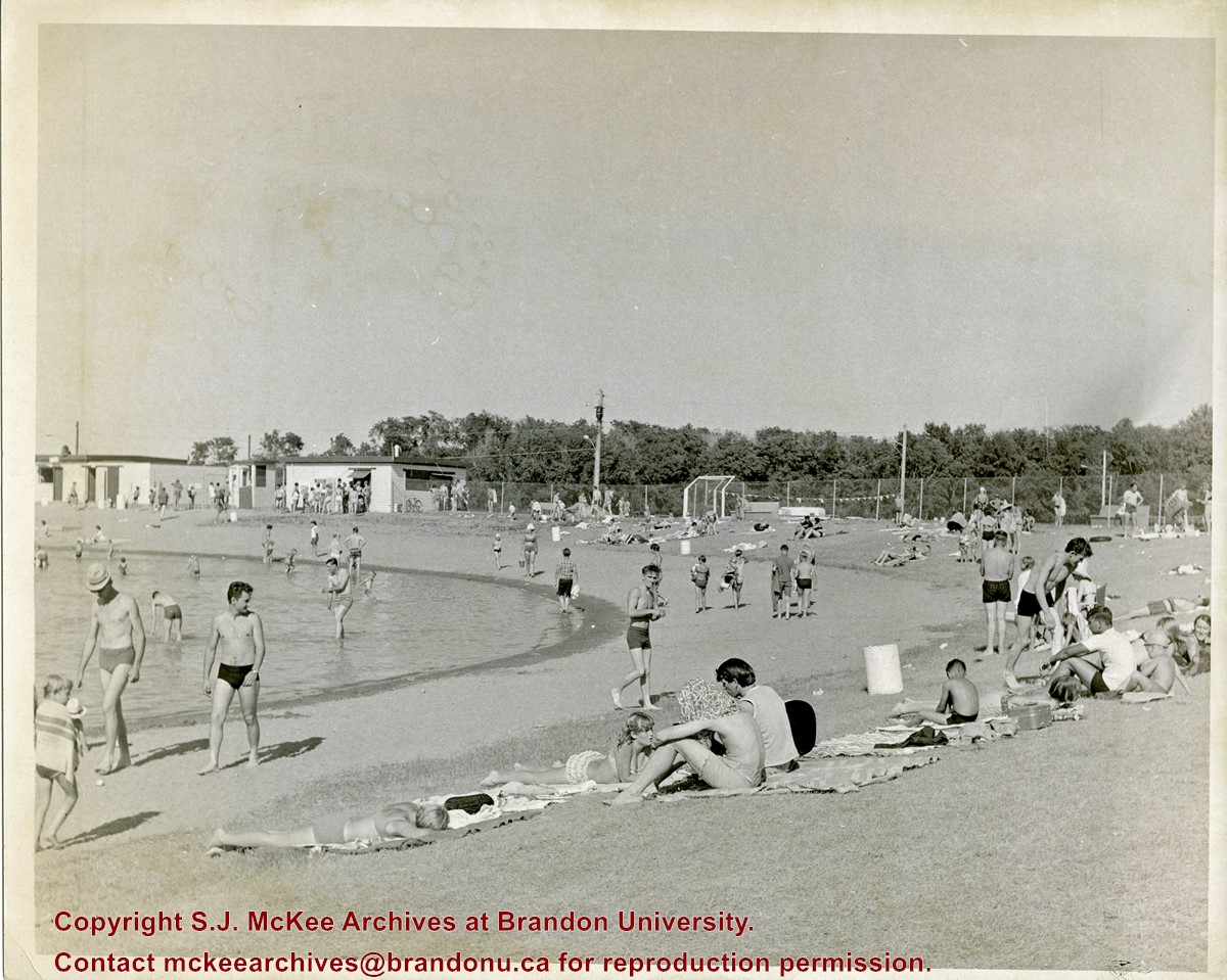
Curran Park is located at 4100 Grand Valley Rd, Brandon, MB. Originally called Suburban Park, it underwent a formal name change in 1934, in honour of J.P. Curran, a lawyer, civil servant and judge, who died in 1928. The City of Brandon first set aside $6000 for the acquisition of a new park in 1911, but the acquisition of appropriate land stalled for a number of years. Finally in 1919, the city was able to acquire a parcel of Crown land the Brandon Industrial School was located on, to establish the park; the land was acquired through a 99-year lease. Suburban Park officialy opened in 1921. The development of the park was gradual. Some of the work was completed as part of the Brandon Parks Board's unemployment relief planning; from 1931-1936, relief workers cleared underbrush, thinned trees, constructed a road and built latrines. In 1933 a refreshment stand was approved and a large cook stove was donated. The City of Brandon and the Department of Agriculture (in right of the Crown) agreed to terminate the original park lease in March 1965, with the city purchasing the land outright. Curran Park was sold to Gretna businessman Gerald Voth in 2001, and renamed Turtle Crossing.
Scope and Content
Item is a photograph of the pool at Curran Park, Brandon, MB.
Notes
History/Bio information was taken from A Cup of Cold Water: Alfred Kirkness and the Brandon Residential School Cemeteries by Anne Lindsay, Clare Cook, and David Cuthbert (Manitoba History journal, Number 78, Summer 2015).
Name Access
Curran Park
Subject Access
swimming
recreation facilities
swimming pools
leisure activities
Storage Location
BAPC photograph drawer
Images
Show Less
Part Of
RG 12 Brandon and Area Photograph Collection
Description Level
Item
GMD
graphic
Date Range
c. 1976
Part Of
RG 12 Brandon and Area Photograph Collection
Description Level
Item
Series Number
1
Item Number
BAPC 1.1
GMD
graphic
Date Range
c. 1976
Physical Description
3.25" x 5.25" (b/w)
Scope and Content
Photograph shows a farmer using a New Holland bale wagon (1048).
Name Access
New Holland
Subject Access
Agriculture
farming
agricultural machinery
rural life
Storage Location
BAPC photograph drawer
Images
Show Less
Part Of
RG 12 Brandon and Area Photograph Collection
Description Level
Item
GMD
graphic
Date Range
c. 1976
Part Of
RG 12 Brandon and Area Photograph Collection
Description Level
Item
Series Number
1
Item Number
BAPC 1.2
GMD
graphic
Date Range
c. 1976
Physical Description
4" x 6" (b/w)
Scope and Content
Photograph shows a farmer baling hay using a New Holland bale wagon.
Name Access
New Holland
Subject Access
Agriculture
farming
agricultural machinery
rural life
Storage Location
BAPC photograph drawer
Images
Show Less

R.H. Leigh's threshing machine

http://archives.brandonu.ca/en/permalink/descriptions10109
Part Of
RG 12 Brandon and Area Photograph Collection
Description Level
Item
GMD
graphic
Date Range
1903
Part Of
RG 12 Brandon and Area Photograph Collection
Description Level
Item
Series Number
1
Item Number
BAPC 1.3
GMD
graphic
Date Range
1903
Physical Description
6.5" x 8.25" (b/w)
Scope and Content
Photograph shows R.H. Leigh's threshing machine and crew during harvest.
Name Access
R.H. Leigh
Subject Access
Agriculture
farming
agricultural machinery
rural life
threshing crews
agricultural labourers
Storage Location
BAPC photograph drawer
Images
Show Less

Bradley Brothers threshing crew of Wheatland, Manitoba

http://archives.brandonu.ca/en/permalink/descriptions10110
Part Of
RG 12 Brandon and Area Photograph Collection
Description Level
Item
GMD
graphic
Date Range
[19-?]
Part Of
RG 12 Brandon and Area Photograph Collection
Description Level
Item
Series Number
1
Item Number
BAPC 1.4
GMD
graphic
Date Range
[19-?]
Physical Description
5" x 7" (b/w)
Material Details
On matting
Scope and Content
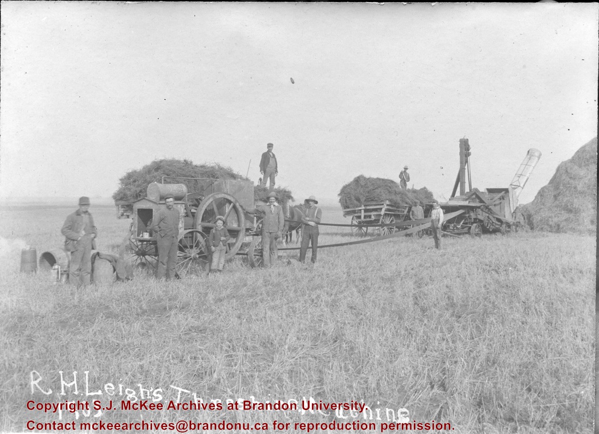
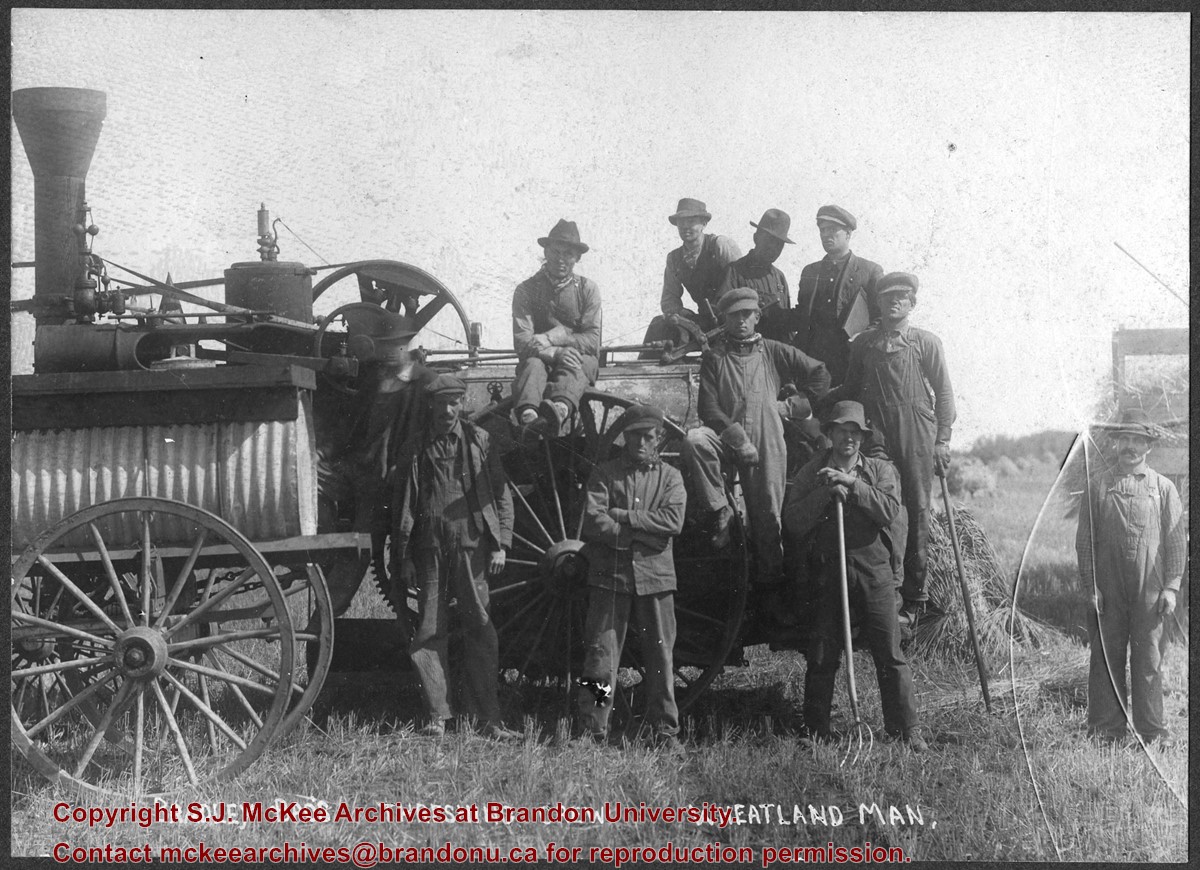
Photograph shows the Bradley Bros. threshing crew of Wheatland, MB posing in a field. Faint writing in pencil on the back of the photo reads: Bill Le Paga(?), Tom B, Dave R., Andy R.
Subject Access
Agriculture
farming
agricultural machinery
rural life
threshing crews
agricultural labourers
Storage Location
BAPC oversize storage drawer
Images
Show Less

Brandon University Alumni Association parade march

http://archives.brandonu.ca/en/permalink/descriptions10123
Part Of
RG 12 Brandon and Area Photograph Collection
Description Level
Item
GMD
graphic
Date Range
1980
Part Of
RG 12 Brandon and Area Photograph Collection
Description Level
Item
Series Number
2
Item Number
BAPC 2.10
GMD
graphic
Date Range
1980
Physical Description
5" x 7" (b/w)
Scope and Content
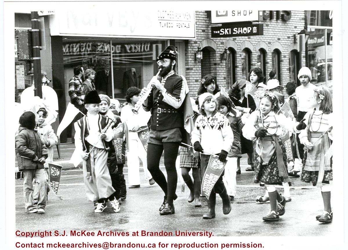
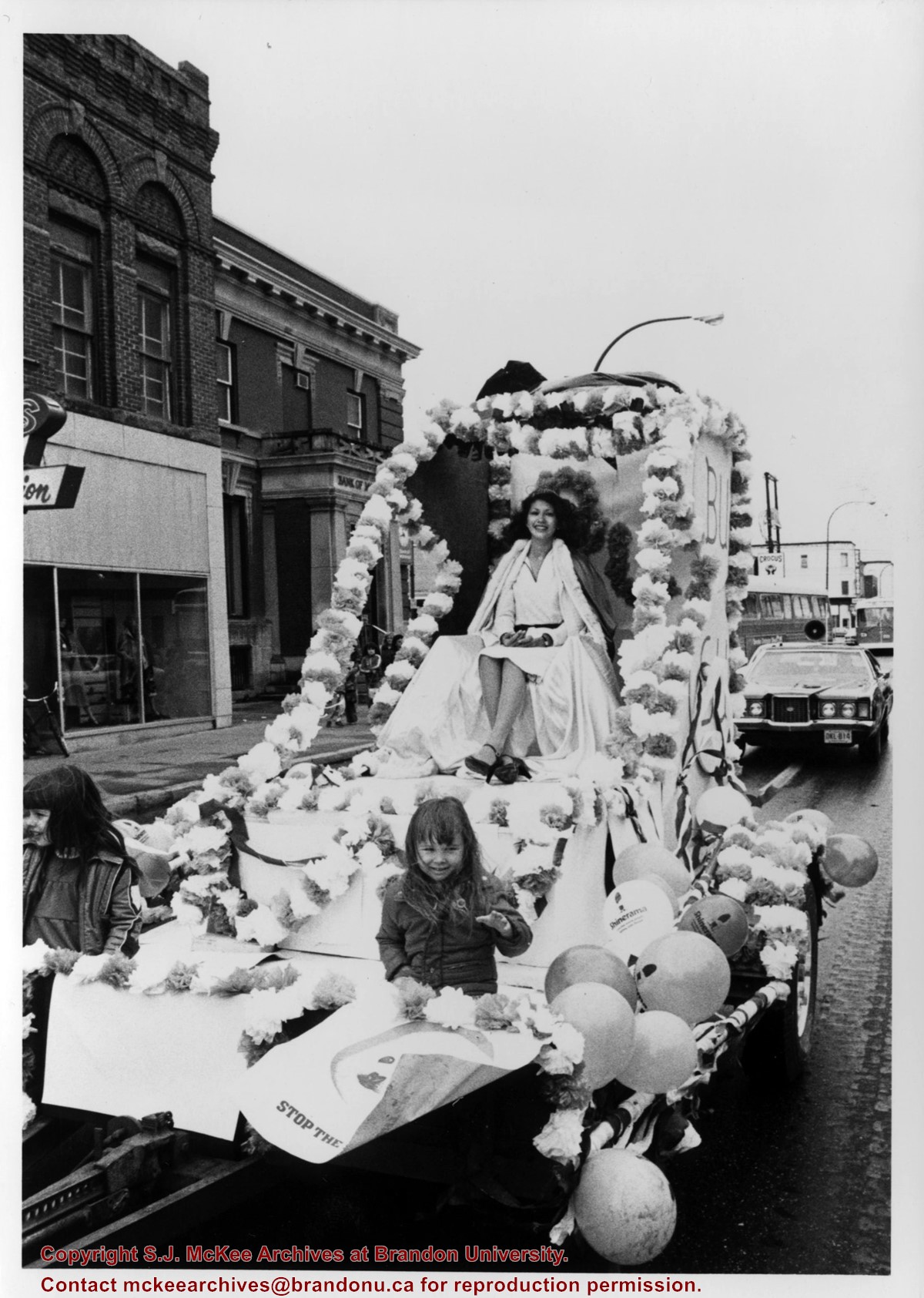
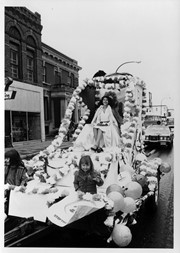
Photograph shows Robert (Bob) Ford dressed as the Pied Piper playing a soprano saxophone surrounded by children in costume, some carrying Brandon University Alumni pennants. Photo was taken during the Brandon University Homecoming Parade held in downtown Brandon.
Name Access
Brandon University Alumni Association
Bob Ford
Narvey's
The Ski Shop
Dirty Don's Denim
Don Gardener's
Robert Ford
Subject Access
parades
floats
public ceremonies
homecoming
university activities
Storage Location
BAPC photograph drawer
Images
Show Less

BUSU homecoming parade float

http://archives.brandonu.ca/en/permalink/descriptions10124
Part Of
RG 12 Brandon and Area Photograph Collection
Description Level
Item
GMD
graphic
Date Range
1979
Part Of
RG 12 Brandon and Area Photograph Collection
Description Level
Item
Series Number
2
Item Number
BAPC 2.11
GMD
graphic
Date Range
1979
Physical Description
5" x 7" (b/w)
Scope and Content
Photograph of the Brandon University Students' Union (BUSU) float in Brandon University's homecoming parade.
Name Access
Shinerama
BUSU
Bank of Montreal
Rosser Avenue
Crocus Credit Union
Yukon Block
Subject Access
parades
floats
public ceremonies
homecoming
university activities
Storage Location
BAPC photograph drawer
Images
Show Less

John R. Brodie Science Centre flower beds

http://archives.brandonu.ca/en/permalink/descriptions3019
Part Of
Brandon University Photograph collection
Description Level
Item
GMD
graphic
Date Range
May 1978
Part Of
Brandon University Photograph collection
Description Level
Item
Series Number
2.1
Item Number
BUPC 2.1.40
GMD
graphic
Date Range
May 1978
Physical Description
5" x 3.5"
Scope and Content
Photograph shows a number of the flower beds located on the north side of the John R. Brodie Science Centre.
Subject Access
campus photographs
Show Less
Part Of
Brandon University Photograph collection
Description Level
Item
GMD
graphic
Date Range
May 1978
Part Of
Brandon University Photograph collection
Description Level
Item
Series Number
2.1
Item Number
BUPC 2.1.41
GMD
graphic
Date Range
May 1978
Physical Description
5" x 3.5" (colour)
Scope and Content
Photograph shows a sign bearing a campus map. The sign was located at the north entrance to the driveway.
Subject Access
campus photographs
Images
Show Less

John R. Brodie Science Centre flower beds

http://archives.brandonu.ca/en/permalink/descriptions3026
Part Of
Brandon University Photograph collection
Description Level
Item
GMD
graphic
Date Range
May 1978
Part Of
Brandon University Photograph collection
Description Level
Item
Series Number
2.1
Item Number
BUPC 2.1.42
GMD
graphic
Date Range
May 1978
Physical Description
5" x 3.5" (colour)
Scope and Content
Photograph shows a number of flower beds located on the north side of the John R. Brodie Science Centre.
Subject Access
campus photographs
Images
Show Less

Aerial view - Brandon University campus

http://archives.brandonu.ca/en/permalink/descriptions7989
Part Of
Brandon University Photograph collection
Description Level
Item
GMD
graphic
Date Range
c. 2000
Part Of
Brandon University Photograph collection
Creator
Photograph commissioned by Brandon University and taken by Yourview Aerial Scenics Ltd.
Description Level
Item
Series Number
2.1
Item Number
BUPC 2.1.55
GMD
graphic
Date Range
c. 2000
Physical Description
6" x 4" (colour)
Scope and Content
View is southwest from approximatley 16th Street between Princess and Rosser Avenues. Photograph shows the Brandon University campus, as well as surrounding residential blocks, including Flemming, J.R. Reid and Vincent Massey schools.
Subject Access
aerial photographs
campus photographs
campus buildings
Brandon streets
Images
Show Less

Aerial view - Brandon University campus

http://archives.brandonu.ca/en/permalink/descriptions7990
Part Of
Brandon University Photograph collection
Description Level
Item
GMD
graphic
Date Range
c. 2000
Part Of
Brandon University Photograph collection
Creator
Photograph commissioned by Brandon University and taken by Yourview Aerial Scenics Ltd.
Description Level
Item
Series Number
2.1
Item Number
BUPC 2.1.56
GMD
graphic
Date Range
c. 2000
Physical Description
6" x 4" (colour)
Scope and Content
View is west southwest from approximatley 16th Street between Princess and Lorne Avenues. Photograph shows the Brandon University campus, as well as surrounding residential blocks between 16th and 23rd Streets, Princess and Louise Avenues..
Subject Access
aerial photographs
campus photographs
campus buildings
Brandon streets
Images
Show Less

Aerial view - Brandon University campus

http://archives.brandonu.ca/en/permalink/descriptions7991
Part Of
Brandon University Photograph collection
Description Level
Item
GMD
graphic
Date Range
c. 2000
Part Of
Brandon University Photograph collection
Creator
Photograph commissioned by Brandon University and taken by Yourview Aerial Scenics Ltd.
Description Level
Item
Series Number
2.1
Item Number
BUPC 2.1.57
GMD
graphic
Date Range
c. 2000
Physical Description
6" x 4" (colour)
Scope and Content
View is west from approximatley 17th Street between Lorne and Louise Avenues. Photograph shows a portion of the Brandon University campus (excluding the Education Building and anything north of it), as well as surrounding residential blocks from approximatley 17th Street to 22nd Street.
Subject Access
aerial photographs
campus photographs
campus buildings
Brandon streets
Images
Show Less

Aerial view - Brandon University campus

http://archives.brandonu.ca/en/permalink/descriptions7992
Part Of
Brandon University Photograph collection
Description Level
Item
GMD
graphic
Date Range
c. 1990
Part Of
Brandon University Photograph collection
Description Level
Item
Series Number
2.1
Item Number
BUPC 2.1.58
GMD
graphic
Date Range
c. 1990
Physical Description
5" x 3.5" (colour)
Scope and Content
View is west northwest from approximatley 16th Street and Louise Avenue. Photograph shows the Brandon University campus, prior to the Library Extension, and a large portion of the city to the west of the campus.
Subject Access
aerial photographs
campus photographs
campus buildings
Brandon streets
Images
Show Less

Aerial view - Brandon University campus

http://archives.brandonu.ca/en/permalink/descriptions7993
Part Of
Brandon University Photograph collection
Description Level
Item
GMD
graphic
Date Range
c. 1990
Part Of
Brandon University Photograph collection
Description Level
Item
Series Number
2.1
Item Number
BUPC 2.1.59
GMD
graphic
Date Range
c. 1990
Physical Description
5" x 3.5" (colour)
Scope and Content
View is northwest from approximatley 16th Street and Louise Avenue. Photograph shows the Brandon University campus, prior to the Library Extension, and a large portion of the city to the west of the campus.
Subject Access
aerial photographs
campus photographs
campus buildings
Brandon streets
Show Less
Part Of
Brandon University Photograph collection
Description Level
Item
GMD
graphic
Date Range
c. 1985
Part Of
Brandon University Photograph collection
Description Level
Item
Series Number
2.1
Item Number
BUPC 2.1.60
GMD
graphic
Date Range
c. 1985
Physical Description
5" x 3.5" (colour)
Scope and Content
Photograph shows the removal of one of the houses formerly located on 20th Street between Louise and Princess Avenues. The houses on those blocks were removed to create parking lots for the University. A Fed Zavislak Ltd. Well Drilling & Trucking pickup truck is visible at the curb.
Subject Access
campus photographs
Brandon streets
Images
Show Less
Part Of
Brandon University Photograph collection
Description Level
Item
GMD
graphic
Date Range
c. 1985
Part Of
Brandon University Photograph collection
Description Level
Item
Series Number
2.1
Item Number
BUPC 2.1.61
GMD
graphic
Date Range
c. 1985
Physical Description
5" x 3.5" (colour)
Scope and Content
Photograph shows the removal of one of the houses formerly located on 20th Street between Louise and Princess Avenues. The houses on those blocks were removed to create parking lots for the University.
Subject Access
campus photographs
Brandon streets
Images
Show Less
Part Of
Brandon University Photograph collection
Description Level
Item
GMD
graphic
Date Range
May 12, 1992
Part Of
Brandon University Photograph collection
Description Level
Item
Series Number
2.1
Item Number
BUPC 2.1.62
GMD
graphic
Date Range
May 12, 1992
Physical Description
5.75" x 3.75" (colour)
Scope and Content
Photograph shows a backhoe digging a sewer hole near the sidewalk between the Brandon College Building and the Citizens' Science Building. The Knowles-Douglas Students' Union Centre, John R. Brodie Science Centre and a portion of the driveway are visible in the background.
Subject Access
campus photographs
campus buildings
campus construction
Images
Show Less

Brandon University campus

http://archives.brandonu.ca/en/permalink/descriptions7997
Part Of
Brandon University Photograph collection
Description Level
Item
GMD
graphic
Date Range
c. 1996
Part Of
Brandon University Photograph collection
Creator
Photographer: Sandy Black
Description Level
Item
Series Number
2.1
Item Number
BUPC 2.1.63
GMD
graphic
Date Range
c. 1996
Physical Description
6" x 4" (colour)
Scope and Content
View is northwest from the roof of the John R. Brodie Science Centre. Photograph shows the roof of the Knowles Douglas Students' Union Centre, the Citizens' Science Building, and the Brandon College Building and Clark Hall during renovation.
Subject Access
campus photographs
campus buildings
campus construction
Images
Show Less

Brandon University campus

http://archives.brandonu.ca/en/permalink/descriptions7998
Part Of
Brandon University Photograph collection
Description Level
Item
GMD
graphic
Date Range
c. 1993
Part Of
Brandon University Photograph collection
Description Level
Item
Series Number
2.1
Item Number
BUPC 2.1.64
GMD
graphic
Date Range
c. 1993
Physical Description
6" x 4" (colour)
Scope and Content
Photograph was taken from the roof of the Library and shows the walkway and flower bed on the southeast corner of the George T. Richardson Centre. The Physical Plant H-Hut is visible in the top right hand corner.
Subject Access
campus photographs
Images
Show Less

20 records – page 1 of 1.