View is southwest from approximatley 16th Street between Princess and Rosser Avenues. Photograph shows the Brandon University campus, as well as surrounding residential blocks, including Flemming, J.R. Reid and Vincent Massey schools.
View is west southwest from approximatley 16th Street between Princess and Lorne Avenues. Photograph shows the Brandon University campus, as well as surrounding residential blocks between 16th and 23rd Streets, Princess and Louise Avenues..
View is west from approximatley 17th Street between Lorne and Louise Avenues. Photograph shows a portion of the Brandon University campus (excluding the Education Building and anything north of it), as well as surrounding residential blocks from approximatley 17th Street to 22nd Street.
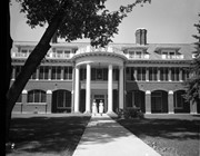
Built in 1991-1992 for $1.4 million, the official opening of the Centre was May 29, 1992. The centre is currently (April 2010) called the Addictions Foundation of Manitoba, Parkwood Centre.
Custodial History
For custodial history see the collection level description of the Lawrence Stuckey collection.
Scope and Content
Alcoholism Foundation of Manitoba (AFM), Parkwood Treatment Centre located on Victoria Avenue East.
Built in 1991-1992 for $1.4 million, the official opening of the Centre was May 29, 1992. The centre is currently (April 2010) called the Addictions Foundation of Manitoba, Parkwood Centre.
Custodial History
For custodial history see the collection level description of the Lawrence Stuckey collection.
Scope and Content
Alcoholism Foundation of Manitoba (AFM), Parkwood Treatment Centre.
See fonds level of the CKX records for custodial history.
Scope and Content
Image consists of an aerial view looking north at the intersection of Highways 1 and 10 and shows the British American dealer located at the intersection.
See fonds level of the CKX records for custodial history.
Scope and Content
Image consists of an aerial view looking southeast at the intersection of Highways 1 and 10 and shows the British American dealer located at the intersection.
See fonds level of the CKX records for custodial history.
Scope and Content
Image consists of an aerial view looking northeast at the intersection of Highways 1 and 10 and shows the British American dealer located at the intersection.


.jpg?width=1200&404=no-img.jpg&watermark=wmk)
.jpg?width=180&404=no-img.jpg)
.jpg?width=1200&404=no-img.jpg&watermark=wmk)
.jpg?width=180&404=no-img.jpg)


.jpg%3fmaxheight%3d1000%26maxwidth%3d1000%26watermark%3dwmk&description=Alcoholism+Foundation+of+Manitoba%2c+Parkwood+Treatment+Centre)
.jpg%3fmaxheight%3d1000%26maxwidth%3d1000%26watermark%3dwmk&description=Alcoholism+Foundation+of+Manitoba+Parkwood+Treatment+Centre)
)