For custodial history see the collection level description of the Lawrence Stuckey collection.
Scope and Content
Photograph is looking east down Lorne Avenue East from approximately the 13th Avenue East intersection. On the north side of the street are the Hillside Townhouses with the Lady Sylvia apartment block and Simplot Canada Ltd. in the background.
The McKee Archives is the copyright holder for the Stuckey materials.
Location Copy
1-2002.3.9.110
Storage Location
Lawrence Stuckey collection
Arrangement
[Mr. Stuckey put 5 and 5 prints negatives in the same envelope. We have separated them and numbered the negatives CA15(1) to CA15(5), and the corresponding prints CA15(1a) to CA15(5a).]
Photographs have been glued to a backing board that has warped over time
History / Biographical
Photograph of possible Dakota from Sioux Valley in Brandon for the summer fair.
Scope and Content
Photograph shows street view of north side of Rosser Avenue, primarily the 700 block. Businesses visible in the Beaubier Block include the Empire Hotel. Businesses east of the Empire Hotel are grocer A.M. Percival, the Brandon Hardware Company, and the Arlington Hotel. A number of Aboriginal peoples are driving horse and buggies east along Rosser Avenue as large numbers of spectators look on.
Notes
Writing on the front of the photograph matting reads: 298. One photograph (20-2009.79) is glued above, another (20-2009.81) adjacent. One other is glued on the reverse side. Page appears to be from a photo album.
Photographs have been glued to a backing board that has warped over time
Custodial History
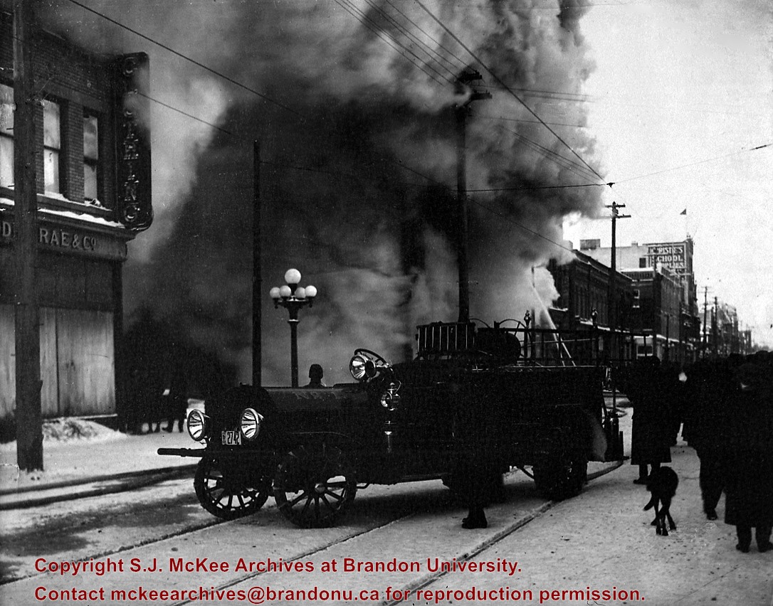
On 16 November 1906, Manitoba was hit by a severe winter storm that began that Thursday evening and extended through the weekend. The Brandon Daily Sun ("Storm Extends Over a Large Territory," 17 Nov. 1906, 1) reported that rail and telegraph services had been disrupted, country roads were impassable, and business in town was at a stand still. Following the weekend, the daily reported the blizzard was one of the greatest in recent memory. CPR trains had been caught in drifts by Carberry and an express car had caught fire and was destroyed ("Worst Storm in Many Years," Brandon Daily Sun, 19 Nov. 1906, 1).
Scope and Content
Photograph shows street view of north side of Rosser Avenue, primarily the 700 block. The Fleming Block, Beaubier Block and its Empire Hotel, A.M. Percival (a grocer), the Brandon Hardware Company (600 block), and the Arlington Hotel (500 block) are visible along the north side of the avenue. The Bank of Hamilton Building on the southeast corner of 8th Street and Rosser appears to be under construction. The streets are muddy and a horse and buggy is traveling west on Rosser Avenue.
Notes
Writing on the front of the photograph matting reads: during the great storm of November 16 1906, 341. The photograph appears to be taken from the interior of a builing on the southwest corner of 7th Street and Rosser Avenue. Page appears to be from a photo album.
Item is a postcard. Image is looking northwest onto Rosser Avenue at approximatley 9th Street. Visible are the Bank of Nova Scotia (corner of 10th and Rosser), the Clement Block (formerly corner of 9th and Rosser), Tip Top Tailors, the Met Cafe, and Brown's Drug Store.
Notes
Corresponds with negative 1-2002.3.1.CA9.
Repro Restriction
The McKee Archives is the copyright holder for the Stuckey materials.
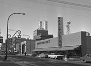
Photograph is looking east southeast along Rosser Avenue at 9th Street. Visible are: Maxine's Fabrics and Crafts, Mitro block (838 Rosser Avenue), Vogue, Ressor's, Metropolitan Store, Johnston's Drugs, Royal Bank of Canada, Eaton's, Kennedy's.
Repro Restriction
The McKee Archives is the copyright holder for the Stuckey materials.
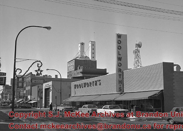
Photograph is looking west northwest along Rosser Avenue and showing the north side of the street starting at the 700 block. Visible are: Woolworth's, Canadian Imperial Bank of Commerce and Dayton's. McKenzie Seeds is in the background.
Repro Restriction
The McKee Archives is the copyright holder for the Stuckey materials.
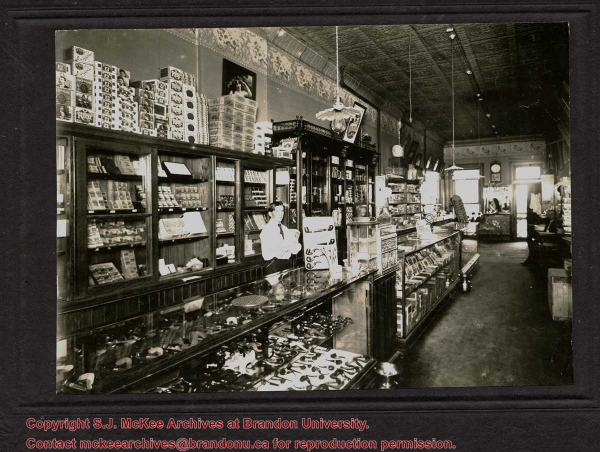
The decorative ceiling and border are consistent with another photograph in the McGuinness collection (see 20-2009.78) in which Gordon Irwin is identified. According to Henderson's 1909 Brandon City Directory, Gordon Irwin - a barber - and tobacconist J.S. Rosby shared at storefront at 919 Rosser Avenue. This address is situated on the north side of Rosser Avenue, adjacent to a laneway. It is possible that the back of the shop overlooks the Grand Union Hotel on the corner of Pacific Avenue and 10th Street.
Scope and Content
Photograph shows the interior of a store primarily selling pipes and cigars. An ornate tin ceiling and wallpaper border are evident. A barber shop area can be seen in the back of the shop near the exit.
Notes
Writing on the back reads: Harold Tackaberry says may have been Jory's or Waldron's, now part of Knowlton's. The handwriting is Fred McGuinness'.
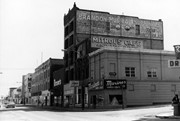
The Brandon Club (L. of center) was built in 1904. This local businessmen's club met in the old firehall until this building was erected by them.
[The Brandon Club closed and its assets were sold at auction on 18 June 2005. P.E. 01/06/2009]
Custodial History
For custodial history see the collection level description of the Lawrence Stuckey collection.
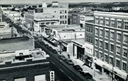
Scope and Content
Overhead view of Princess Avenue, west of 10th Street
Notes
Taken from roof of Prince Edward Hotel. Shows: Rat Portage Lumber Co., St. Matthew's Hall, Brandon Club, In distance Brandon College, International Harvester, Pumping Station. End of brick pavement at 14th Street is notable.
Photographs have been glued to a backing board that has warped over time
Scope and Content
Photograph shows street view of north side of Rosser Avenue, primarily the 700 block. The Fleming Block, Beaubier Block and its Empire Hotel, A.M. Percival (a grocer), the Brandon Hardware Company (600 block), and the Arlington Hotel (500 block) are visible along the north side of the avenue. The Bank of Hamilton Building on the southeast corner of 8th Street and Rosser appears to be under construction. A sign in the second storey window above the main entrance reads: law office. The streets are muddy and a horse and buggy is traveling west on Rosser Avenue.
Notes
Writing on the front of the photograph matting reads: mud November 12, 1906, 339. The photograph appears to be taken from the interior of a builing on the southwest corner of 8th Street and Rosser Avenue. Page appears to be from a photo album.
For custodial history see the collection level description of the Lawrence Stuckey collection.
Scope and Content
View of Assiniboine Avenue running west, from Ninth Street North
Notes
Second building from right - Westbrook & Fairchild Implements. At left - Western Hotel; Data [courtesy of] Roy Brown from Henderson's [Directory]; From Manitoba Archives
For custodial history see the collection level description of the Lawrence Stuckey collection.
Scope and Content
View of the southeast corner of Tenth Street and Princess Avenue, showing the Prince Edward Hotel (left) and an Imperial Oil Building (right).
Notes
The second floor of the Imperial Oil building became the Imperial Dance Garden in 1934. The small wooden post in a concrete foundation in the centre of the intersection was called a "Silent Policeman". You were supposed to keep it on your left while making a left turn. They took quite a beating.
[Information in "Notes" provided by the Fred McGuinness collection (20-2009).]
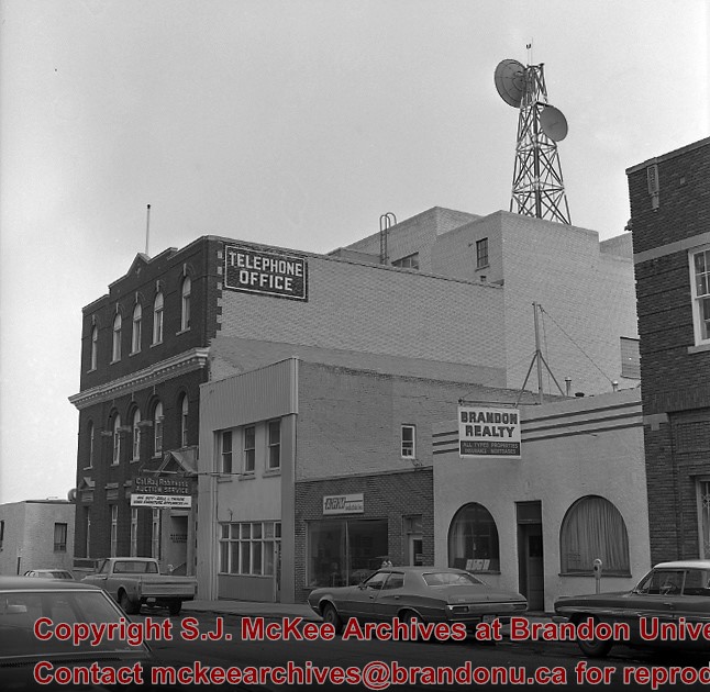
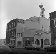
Photograph is looking northeast and shows Brandon Realty, ARM Industries Inc. (silk screen printers), Col. Ray Robinson's Auction Services, and the MTS building.
Repro Restriction
The McKee Archives is the copyright holder for the Stuckey materials.
.jpg?width=1200&404=no-img.jpg&watermark=wmk)
.jpg?width=180&404=no-img.jpg)


.jpg?width=1200&404=no-img.jpg&watermark=wmk)
.jpg?width=180&404=no-img.jpg)


.jpg?width=1200&404=no-img.jpg&watermark=wmk)
.jpg?width=180&404=no-img.jpg)


.jpg%3fmaxheight%3d1000%26maxwidth%3d1000%26watermark%3dwmk&description=Townhouses+on+Lorne+Avenue+East)
.jpg%3fmaxheight%3d1000%26maxwidth%3d1000%26watermark%3dwmk&description=Princess+Avenue+east+of+Tenth+Street)
.jpg%3fmaxheight%3d1000%26maxwidth%3d1000%26watermark%3dwmk&description=Pacific+Avenue+-+west+of+Tenth+Street)