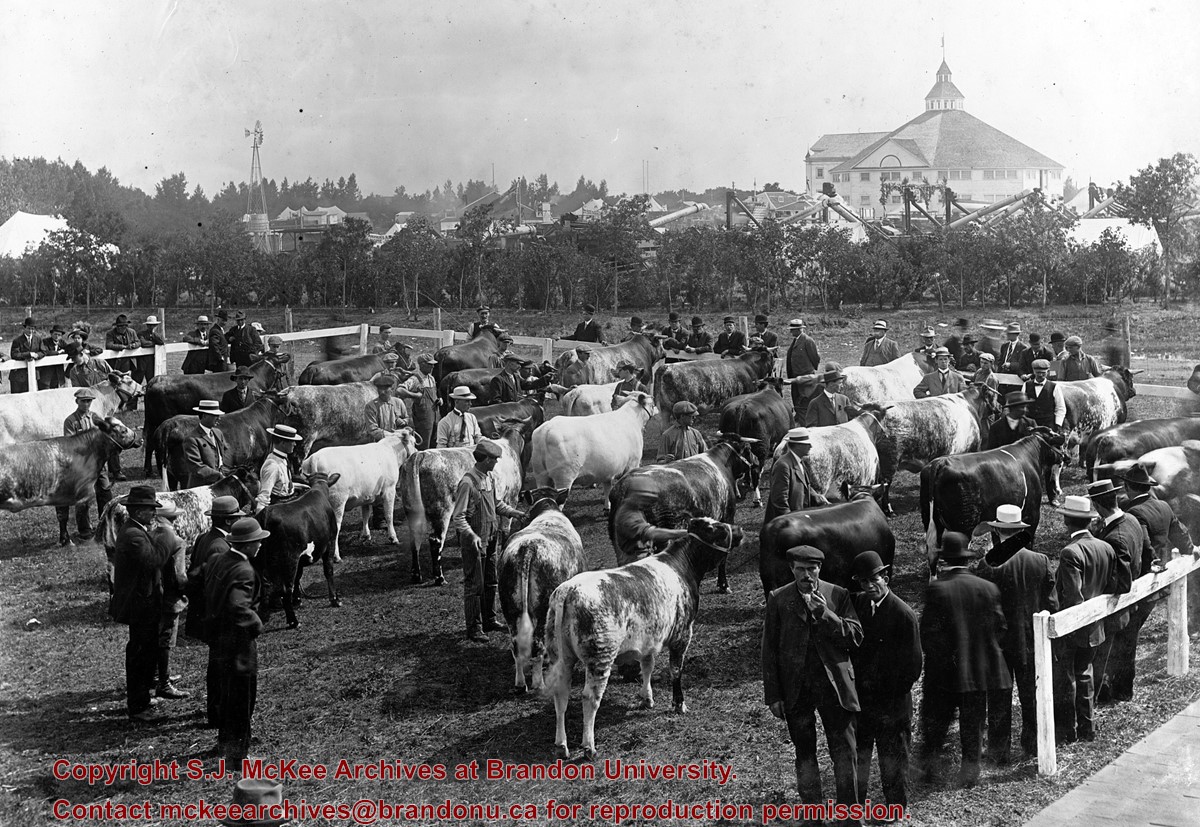
Crystal Palace built 1904 ((Nor'West Farmer 20/08/1904); "Finishing touches" applied 1913 (Barker, p. 154); Demolished, but material saved, in 1939
[Display Building II, the last surviving building of those constructed for the Dominion Fair held in Brandon in 1913, has been named one of the 10 most endangered historic buildings in the country by the Heritage Canada Foundation. P.E. 09/07/09.]
Custodial History
For custodial history see the collection level description of the Lawrence Stuckey collection.
Scope and Content
Dominion Exhibition Display Building II and Crystal Palace at Brandon fairgrounds
The Medicine Hat Exhibition and Stampede Parade Day was held on Thursday, July 19, 1962, at 9:30 a.m. The local newspaper reported that approximately 24,000 people were in attendance to see parade marshall Rod Ashburner leading 175 entries consisting of 90 floats, 75 horses, and 10 bands. There were 19 parade categories eligible for $12,000 in prize money and included: junior and senior cowboys and cowgirls; fancy and Shetland ponies; sulky class open; comic, commercial, industrial and organizational floats; decorated cars; special ranch class; 4-H Clubs; and a non-competitive class.
The parade route started at Second St. and Allowance Ave., from Second St. to Ash Ave., north on Ash to First St. SE., from First St. S.E. to Fourth Ave., south to Second St. to South Railway St., south on South Railway St. to Third St., with a finish at McLeod Trail. A route map was published in the Medicine Hat News the day before the parade.
Aerial photographs of the parade were taken by Medicine Hat News photographer Howard Heid (1930-2005) from the private helicopter of John Bourn. Bourn was a pilot from Woodville, Wisconsin, who chartered his four-seater helicopter for sight-seers at exhibitions and stampedes across the county.
(Sources: Pat Currie, "Let 'Er Go!," Medicine Hat News, 19 July 1962,1; Harald Gunderson, "'Eye in the Sky' Best Parade View," Medicine Hat News, 19 July 1962,1; "Parade Starts at 9:30 Sharp," 18 July 1962)
Scope and Content
Photograph shows an aerial view of the Medicine Hat Exhibition and Stampede Parade route, with a focus on Second Street SE. A residential area showing homes with extensive backyard gardens can be seen. The South Saskatchewan River can be see on the right of the photograph.
Notes
This photograph shows the neighbourhood before rezoning and commercial development.
The Medicine Hat Exhibition and Stampede Parade Day was held on Thursday, July 19, 1962, at 9:30 a.m. The local newspaper reported that approximately 24,000 people were in attendance to see parade marshall Rod Ashburner leading 175 entries consisting of 90 floats, 75 horses, and 10 bands. There were 19 parade categories eligible for $12,000 in prize money and included: junior and senior cowboys and cowgirls; fancy and Shetland ponies; sulky class open; comic, commercial, industrial and organizational floats; decorated cars; special ranch class; 4-H Clubs; and a non-competitive class.
The parade route started at Second St. and Allowance Ave., from Second St. to Ash Ave., north on Ash to First St. SE., from First St. S.E. to Fourth Ave., south to Second St. to South Railway St., south on South Railway St. to Third St., with a finish at McLeod Trail. A route map was published in the Medicine Hat News the day before the parade.
Aerial photographs of the parade were taken by Medicine Hat News photographer Howard Heid (1930-2005) from the private helicopter of John Bourn. Bourn was a pilot from Woodville, Wisconsin, who chartered his four-seater helicopter for sight-seers at exhibitions and stampedes across the county.
(Sources: Pat Currie, "Let 'Er Go!," Medicine Hat News, 19 July 1962,1; Harald Gunderson, "'Eye in the Sky' Best Parade View," Medicine Hat News, 19 July 1962,1; "Parade Starts at 9:30 Sharp," 18 July 1962)
Scope and Content
Photograph shows an aerial view of the Medicine Hat Exhibition and Stampede Parade route, with a focus on Second Street SE. Visible store signs include: China Wonderland, Grey Cup Cafe, Lane Bros. & Gibson Ltd., Joy's, Marshall's, Monarch, Gardener's Used Cars, Provincial Treasury Branch, Furvey's Furniture and Appliances, J.J. Moore & Son, Club Cafe, Black Hardware Ltd., Regency Billards, and Sair's Shoe Hospital.
The Medicine Hat Exhibition and Stampede Parade Day was held on Thursday, July 19, 1962, at 9:30 a.m. The local newspaper reported that approximately 24,000 people were in attendance to see parade marshall Rod Ashburner leading 175 entries consisting of 90 floats, 75 horses, and 10 bands. There were 19 parade categories eligible for $12,000 in prize money and included: junior and senior cowboys and cowgirls; fancy and Shetland ponies; sulky class open; comic, commercial, industrial and organizational floats; decorated cars; special ranch class; 4-H Clubs; and a non-competitive class.
The parade route started at Second St. and Allowance Ave., from Second St. to Ash Ave., north on Ash to First St. SE., from First St. S.E. to Fourth Ave., south to Second St. to South Railway St., south on South Railway St. to Third St., with a finish at McLeod Trail. A route map was published in the Medicine Hat News the day before the parade.
Aerial photographs of the parade were taken by Medicine Hat News photographer Howard Heid (1930-2005) from the private helicopter of John Bourn. Bourn was a pilot from Woodville, Wisconsin, who chartered his four-seater helicopter for sight-seers at exhibitions and stampedes across the county.
(Sources: Pat Currie, "Let 'Er Go!," Medicine Hat News, 19 July 1962,1; Harald Gunderson, "'Eye in the Sky' Best Parade View," Medicine Hat News, 19 July 1962,1; "Parade Starts at 9:30 Sharp," 18 July 1962)
Scope and Content
Photograph shows an aerial view of the Medicine Hat Exhibition and Stampede Parade route, with a focus on the First Street SE and North Railway Street merge.
Notes
This photograph appeared on the front page of The Medicine Hat News (19 July 1962).
The Medicine Hat Exhibition and Stampede Parade Day was held on Thursday, July 19, 1962, at 9:30 a.m. The local newspaper reported that approximately 24,000 people were in attendance to see parade marshall Rod Ashburner leading 175 entries consisting of 90 floats, 75 horses, and 10 bands. There were 19 parade categories eligible for $12,000 in prize money and included: junior and senior cowboys and cowgirls; fancy and Shetland ponies; sulky class open; comic, commercial, industrial and organizational floats; decorated cars; special ranch class; 4-H Clubs; and a non-competitive class.
The parade route started at Second St. and Allowance Ave., from Second St. to Ash Ave., north on Ash to First St. SE., from First St. S.E. to Fourth Ave., south to Second St. to South Railway St., south on South Railway St. to Third St., with a finish at McLeod Trail. A route map was published in the Medicine Hat News the day before the parade.
Aerial photographs of the parade were taken by Medicine Hat News photographer Howard Heid (1930-2005) from the private helicopter of John Bourn. Bourn was a pilot from Woodville, Wisconsin, who chartered his four-seater helicopter for sight-seers at exhibitions and stampedes across the county.
(Sources: Pat Currie, "Let 'Er Go!," Medicine Hat News, 19 July 1962,1; Harald Gunderson, "'Eye in the Sky' Best Parade View," Medicine Hat News, 19 July 1962,1; "Parade Starts at 9:30 Sharp," 18 July 1962)
Scope and Content
Photograph shows an aerial view of the Medicine Hat Exhibition and Stampede Parade route with a focus on the First Street SE. A number of gas stations and garages are visible along this route and include Texaco, Shell, Ford, and B/A. The Fraternal Order of Eagles lodge is also visible.
Notes
This photograph appeared on the front page of The Medicine Hat News (19 July 1962).
The Medicine Hat Exhibition and Stampede Parade Day was held on Thursday, July 19, 1962, at 9:30 a.m. The local newspaper reported that approximately 24,000 people were in attendance to see parade marshall Rod Ashburner leading 175 entries consisting of 90 floats, 75 horses, and 10 bands. There were 19 parade categories eligible for $12,000 in prize money and included: junior and senior cowboys and cowgirls; fancy and Shetland ponies; sulky class open; comic, commercial, industrial and organizational floats; decorated cars; special ranch class; 4-H Clubs; and a non-competitive class.
The parade route started at Second St. and Allowance Ave., from Second St. to Ash Ave., north on Ash to First St. SE., from First St. S.E. to Fourth Ave., south to Second St. to South Railway St., south on South Railway St. to Third St., with a finish at McLeod Trail. A route map was published in the Medicine Hat News the day before the parade.
Aerial photographs of the parade were taken by Medicine Hat News photographer Howard Heid (1930-2005) from the private helicopter of John Bourn. Bourn was a pilot from Woodville, Wisconsin, who chartered his four-seater helicopter for sight-seers at exhibitions and stampedes across the county.
(Sources: Pat Currie, "Let 'Er Go!," Medicine Hat News, 19 July 1962,1; Harald Gunderson, "'Eye in the Sky' Best Parade View," Medicine Hat News, 19 July 1962,1; "Parade Starts at 9:30 Sharp," 18 July 1962)
Scope and Content
Photograph shows an aerial view of the Medicine Hat Exhibition and Stampede Parade route with a focus on the First Street SE and Ash Street. A residential area showing homes with extensive backyard gardens can be seen.
Notes
This photograph shows the neighbourhood before rezoning and commercial development.
The Medicine Hat Exhibition and Stampede Parade Day was held on Thursday, July 19, 1962, at 9:30 a.m. The local newspaper reported that approximately 24,000 people were in attendance to see parade marshall Rod Ashburner leading 175 entries consisting of 90 floats, 75 horses, and 10 bands. There were 19 parade categories eligible for $12,000 in prize money and included: junior and senior cowboys and cowgirls; fancy and Shetland ponies; sulky class open; comic, commercial, industrial and organizational floats; decorated cars; special ranch class; 4-H Clubs; and a non-competitive class.
The parade route started at Second St. and Allowance Ave., from Second St. to Ash Ave., north on Ash to First St. SE., from First St. S.E. to Fourth Ave., south to Second St. to South Railway St., south on South Railway St. to Third St., with a finish at McLeod Trail. A route map was published in the Medicine Hat News the day before the parade.
Aerial photographs of the parade were taken by Medicine Hat News photographer Howard Heid (1930-2005) from the private helicopter of John Bourn. Bourn was a pilot from Woodville, Wisconsin, who chartered his four-seater helicopter for sight-seers at exhibitions and stampedes across the county.
(Sources: Pat Currie, "Let 'Er Go!," Medicine Hat News, 19 July 1962,1; Harald Gunderson, "'Eye in the Sky' Best Parade View," Medicine Hat News, 19 July 1962,1; "Parade Starts at 9:30 Sharp," 18 July 1962)
Scope and Content
Photograph shows an aerial view of the Medicine Hat Exhibition and Stampede Parade route with a focus on the First Street SE and and the South Railway Street merge. A number of gas stations and garages are visible along this route and include Texaco, Shell, Ford, and B/A. The Fraternal Order of Eagles lodge is also visible.
Notes
This photograph shows the neighbourhood before rezoning and commercial development.
The Medicine Hat Exhibition and Stampede Parade Day was held on Thursday, July 19, 1962, at 9:30 a.m. The local newspaper reported that approximately 24,000 people were in attendance to see parade marshall Rod Ashburner leading 175 entries consisting of 90 floats, 75 horses, and 10 bands. There were 19 parade categories eligible for $12,000 in prize money and included: junior and senior cowboys and cowgirls; fancy and Shetland ponies; sulky class open; comic, commercial, industrial and organizational floats; decorated cars; special ranch class; 4-H Clubs; and a non-competitive class.
The parade route started at Second St. and Allowance Ave., from Second St. to Ash Ave., north on Ash to First St. SE., from First St. S.E. to Fourth Ave., south to Second St. to South Railway St., south on South Railway St. to Third St., with a finish at McLeod Trail. A route map was published in the Medicine Hat News the day before the parade.
Aerial photographs of the parade were taken by Medicine Hat News photographer Howard Heid (1930-2005) from the private helicopter of John Bourn. Bourn was a pilot from Woodville, Wisconsin, who chartered his four-seater helicopter for sight-seers at exhibitions and stampedes across the county.
(Sources: Pat Currie, "Let 'Er Go!," Medicine Hat News, 19 July 1962,1; Harald Gunderson, "'Eye in the Sky' Best Parade View," Medicine Hat News, 19 July 1962,1; "Parade Starts at 9:30 Sharp," 18 July 1962)
Scope and Content
Photograph shows an aerial view of the Medicine Hat Exhibition and Stampede Parade route with a focus on the First Street SE and Sixth Avenue intersection. A number of gas stations and garages are visible along this route and include Texaco, Shell, Ford, and B/A. A number of observers can be seen sitting on rooftops.
Notes
This photograph shows the neighbourhood before rezoning and commercial development.
The Medicine Hat Exhibition and Stampede Parade Day was held on Thursday, July 19, 1962, at 9:30 a.m. The local newspaper reported that approximately 24,000 people were in attendance to see parade marshall Rod Ashburner leading 175 entries consisting of 90 floats, 75 horses, and 10 bands. There were 19 parade categories eligible for $12,000 in prize money and included: junior and senior cowboys and cowgirls; fancy and Shetland ponies; sulky class open; comic, commercial, industrial and organizational floats; decorated cars; special ranch class; 4-H Clubs; and a non-competitive class.
The parade route started at Second St. and Allowance Ave., from Second St. to Ash Ave., north on Ash to First St. SE., from First St. S.E. to Fourth Ave., south to Second St. to South Railway St., south on South Railway St. to Third St., with a finish at McLeod Trail. A route map was published in the Medicine Hat News the day before the parade.
Aerial photographs of the parade were taken by Medicine Hat News photographer Howard Heid (1930-2005) from the private helicopter of John Bourn. Bourn was a pilot from Woodville, Wisconsin, who chartered his four-seater helicopter for sight-seers at exhibitions and stampedes across the county.
(Sources: Pat Currie, "Let 'Er Go!," Medicine Hat News, 19 July 1962,1; Harald Gunderson, "'Eye in the Sky' Best Parade View," Medicine Hat News, 19 July 1962,1; "Parade Starts at 9:30 Sharp," 18 July 1962)
Scope and Content
Photograph shows an aerial view of the Medicine Hat Exhibition and Stampede Parade route, with a focus on Second Street SE. Visible store signs include: Gardener's Used Cars, Provincial Treasury Branch, Furvey's Furniture and Appliances, J.J. Moore & Son Furniture, Alberta Credit Jewellers, James Richardson & Sons, Medicine Hat Gas Power Water City Owned Utilities.
Notes
This photograph shows the neighbourhood before rezoning and commercial development.
The Medicine Hat Exhibition and Stampede Parade Day was held on Thursday, July 19, 1962, at 9:30 a.m. The local newspaper reported that approximately 24,000 people were in attendance to see parade marshall Rod Ashburner leading 175 entries consisting of 90 floats, 75 horses, and 10 bands. There were 19 parade categories eligible for $12,000 in prize money and included: junior and senior cowboys and cowgirls; fancy and Shetland ponies; sulky class open; comic, commercial, industrial and organizational floats; decorated cars; special ranch class; 4-H Clubs; and a non-competitive class.
The parade route started at Second St. and Allowance Ave., from Second St. to Ash Ave., north on Ash to First St. SE., from First St. S.E. to Fourth Ave., south to Second St. to South Railway St., south on South Railway St. to Third St., with a finish at McLeod Trail. A route map was published in the Medicine Hat News the day before the parade.
Aerial photographs of the parade were taken by Medicine Hat News photographer Howard Heid (1930-2005) from the private helicopter of John Bourn. Bourn was a pilot from Woodville, Wisconsin, who chartered his four-seater helicopter for sight-seers at exhibitions and stampedes across the county.
(Sources: Pat Currie, "Let 'Er Go!," Medicine Hat News, 19 July 1962,1; Harald Gunderson, "'Eye in the Sky' Best Parade View," Medicine Hat News, 19 July 1962,1; "Parade Starts at 9:30 Sharp," 18 July 1962)
Scope and Content
Photograph shows an aerial view of the Medicine Hat Exhibition and Stampede Parade route with a focus on the First Street SE and Ash Street. A residential area showing homes with extensive backyard gardens can be seen.
Notes
This photograph shows the neighbourhood before rezoning and commercial development.
The Medicine Hat Exhibition and Stampede Parade Day was held on Thursday, July 19, 1962, at 9:30 a.m. The local newspaper reported that approximately 24,000 people were in attendance to see parade marshall Rod Ashburner leading 175 entries consisting of 90 floats, 75 horses, and 10 bands. There were 19 parade categories eligible for $12,000 in prize money and included: junior and senior cowboys and cowgirls; fancy and Shetland ponies; sulky class open; comic, commercial, industrial and organizational floats; decorated cars; special ranch class; 4-H Clubs; and a non-competitive class.
The parade route started at Second St. and Allowance Ave., from Second St. to Ash Ave., north on Ash to First St. SE., from First St. S.E. to Fourth Ave., south to Second St. to South Railway St., south on South Railway St. to Third St., with a finish at McLeod Trail. A route map was published in the Medicine Hat News the day before the parade.
Aerial photographs of the parade were taken by Medicine Hat News photographer Howard Heid (1930-2005) from the private helicopter of John Bourn. Bourn was a pilot from Woodville, Wisconsin, who chartered his four-seater helicopter for sight-seers at exhibitions and stampedes across the county.
(Sources: Pat Currie, "Let 'Er Go!," Medicine Hat News, 19 July 1962,1; Harald Gunderson, "'Eye in the Sky' Best Parade View," Medicine Hat News, 19 July 1962,1; "Parade Starts at 9:30 Sharp," 18 July 1962)
Scope and Content
Photograph shows an aerial view of the Medicine Hat Exhibition and Stampede Parade route with a focus west of the railway allowance, showing First Street SE, Second Street SE, and Third Street SE.
Notes
This photograph shows the neighbourhood before rezoning and commercial development.
The Medicine Hat Exhibition and Stampede Parade Day was held on Thursday, July 19, 1962, at 9:30 a.m. The local newspaper reported that approximately 24,000 people were in attendance to see parade marshall Rod Ashburner leading 175 entries consisting of 90 floats, 75 horses, and 10 bands. There were 19 parade categories eligible for $12,000 in prize money and included: junior and senior cowboys and cowgirls; fancy and Shetland ponies; sulky class open; comic, commercial, industrial and organizational floats; decorated cars; special ranch class; 4-H Clubs; and a non-competitive class.
The parade route started at Second St. and Allowance Ave., from Second St. to Ash Ave., north on Ash to First St. SE., from First St. S.E. to Fourth Ave., south to Second St. to South Railway St., south on South Railway St. to Third St., with a finish at McLeod Trail. A route map was published in the Medicine Hat News the day before the parade.
Aerial photographs of the parade were taken by Medicine Hat News photographer Howard Heid (1930-2005) from the private helicopter of John Bourn. Bourn was a pilot from Woodville, Wisconsin, who chartered his four-seater helicopter for sight-seers at exhibitions and stampedes across the county.
(Sources: Pat Currie, "Let 'Er Go!," Medicine Hat News, 19 July 1962,1; Harald Gunderson, "'Eye in the Sky' Best Parade View," Medicine Hat News, 19 July 1962,1; "Parade Starts at 9:30 Sharp," 18 July 1962)
Scope and Content
Photograph shows an aerial view of possibly 8th Street NW and Tweed Avenue NW. A Safeway grocery store, park and residential area are visible. Many of hte homes appear to have gardens.
Notes
This photograph shows the neighbourhood before rezoning and commercial development.
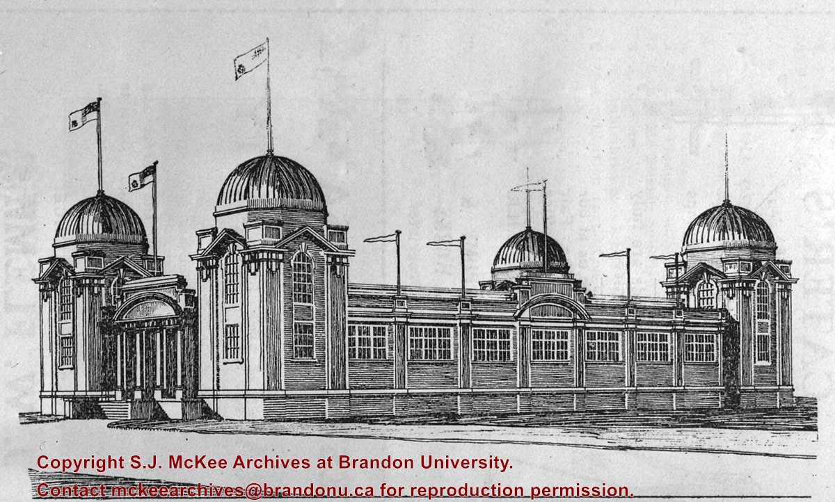
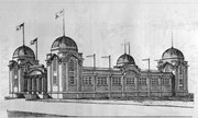
[Display Building II, the last surviving building of those constructed for the Dominion Fair held in Brandon in 1913, has been named one of the 10 most endangered historic buildings in the country by the Heritage Canada Foundation. P.E. 10/07/09.]
Custodial History
For custodial history see the collection level description of the Lawrence Stuckey collection.
Scope and Content
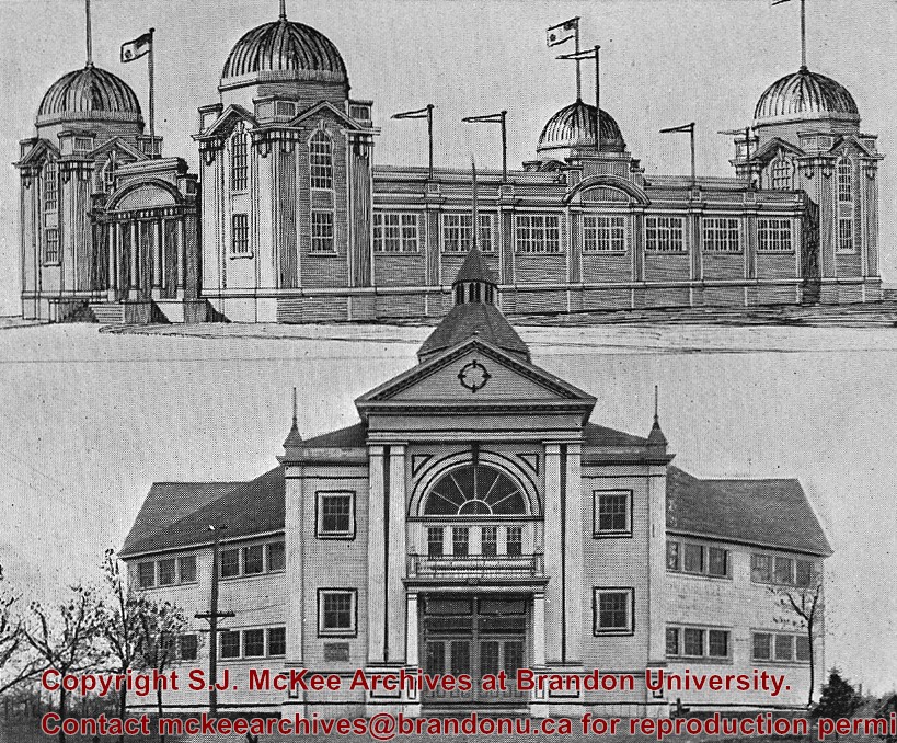
Dominion Exhibition Display Building II at Brandon fairgrounds
Also known as the Mercantile Display Building
Notes
Architect's drawing
Built for the Dominion Fair of 1913 with some alterations from the proposed design shown.
The Brandon University Photograph collection is an artifically created collection. It includes photographs from both Brandon College and Brandon University.
Custodial History
The custodial history is varied. Some photographs were created by officers of the College and the University, or were produced at the request of the institution. Many, as well, have been donated by former faculty members and students. We have tried to record the custodial history for photographs that have been donated by faculty members and students at the item level.
Scope and Content
Fonds has been divided into eleven series, including: (1) Convocation, Scholarships and Awards; (2) Campus Buildings; (3) Library Activities and Archives; (4) Faculties and Schools; (5) Student Activities; (6) Administrative and Support Units; (7) Sports; (8) Portraits; (9) Oversize; (10) Special Events; and (11) Documents, Diplomas and Certificates.
For history/bio information see the fonds level description of the Lawrence Stuckey collection.
Custodial History
The entire collection was housed in Mr. Stuckey's residence at 658 11th St. Brandon, Manitoba, prior to its transfer to the McKee Archives. The balance of the materials, including the photograph negative collection, was deposited in the Archives following Mr. Stuckey's death. Some of the negatives came into Mr. Stuckey's possession when he acquired the Clark J. Smith Studio, Brandon, Man.
Scope and Content
Created by Lawrence A. Stuckey, the collection includes some of his own photography. Stuckey took many of the photos during his travels in Southwestern Manitoba and further afield. As well, he acquired copies of negatives that fit his interest from friends, contemporaries, and other professional photographers. The majority of these copies are of photographs that predate Stuckey's era.
The collection includes various subjects from Brandon’s history (including people, buildings, transportation, railways, and institutions) 1879 to 1992; surrounding communities, railway lines and trains 1925 to 1989; agriculture ca. 1890 to 1983; railway photographs including the Prairie Dog Central, grain cars and various railways, including Canadian Pacific, Canadian National, Great Northern, and Brandon, Saskatchewan & Hudson's Bay, ca. 1900 to 1992; vehicles, planes, and ships ca. 1940 to 1981; personal photographs including friends, travel and other personal interests.
The series has been divided into nine sub-series, including: (1) Brandon history; (2) Westbran project parks; (3) Rural archives; (4) History - miscellaneous (including Walker collection); (5) Grain cars; (6) The prairie dog; (7) Personal interests; (8) Lawrence Stuckey; and (9) Unsorted.
Notes
Funding for series three level descriptions and digitizing of the Lawrence Stuckey fonds has been provided courtesy of a generous grant from the Heritage Grants Advisory Council of the Manitoba Government 2009.
Repro Restriction
The McKee Archives is the copyright holder for the Stuckey materials.
Finding Aid
A copy of the photograph inventory is in the blue binder on the reference shelf in the reading room.
Storage Location
Lawrence Stuckey collection
Arrangement
Subseries 1 - Brandon History
A. People
B. Bridges
C. Streets
D. Buildings
E. Business
F. Fire Dept.
G. Hospitals
H. Industries
I. Streetcars
J. Utilities
K. Construction
L. Transportation (other than rail)
M. Exhibition
N. Misc. History
O. Environs
P. Railroads
Subseries 2 - Westbran Project Parks
Subseries 3 - Rural Archives
1. CPR
-North branches
-Broadview Sub. (Brandon-Broadview)
-CPR lines south of mainline
-Carberry Sub. (Winnipeg-Brandon)
-Minnedosa & Bredenbury Sub's (Ex. Man. & N.W. Ry.) (Portage la Prairie-Minnedosa-Bredenbury)
2. CNR
-Mainline, Rivers Sub. (Winnipeg-Melville)
-Gladstone Sub. (Portage-Neepawa)
-Wawanesa Sub. (Brandon [M&B Jct]-Belmont)
-Rapid City Sub. (Hallboro-Beulah)
-Rossburn Sub. (Neepawa-Russell)
3. Surrounding Communities
-Brandon NW
-Brandon NE
-Brandon SW
-Brandon SE
4. Agriculture (Steam)
5. Agriculture (Horse & Misc)
6. Agriculture (Miscellaneous)
Subseries 4 - History - Miscellaneous (inc. Walker Collection)
Subseries 5 - Grain Cars
Subseries 6 - The Prairie Dog
Subseries 7 - Personal Interests
Subseries 8 - Lawrence Stuckey
-Friends & Personal 1975-
-Travel
-Cars & Planes
-Ships
-Ships & Boats
-Great Lakes Seaway
-Ships & Canal, Duluth, Minn. Sept. 1980
-Windsor & Toronto 1980, 1981
-Welland Canal 1981


